| Title Starbucks Expansion in El Dorado County | |
|
Author Monica Garcia American River College, Geography 350: Data Acquisition in GIS; Spring 2005 Contact Information (garciam_gis@yahoo.com) | |
|
Abstract Businesses today are investing a great deal of money in marketing their product or company. In addition there are many companies that merge with their competitors in order to increase their monopoly in their field. Doing all of this is very expensive and corporations need to know as soon as possible if their locations will be profitable. GIS is allowing corporations that ability while saving them money. Finding an ideal location for a new Starbucks store in El Dorado County is a practical application of resources and funds. Four data layers were converted to raster files and calculated using raster calculator. From these results five sites were selected for a new Starbucks store in El Dorado County. | |
|
Introduction Starbucks in collaboration with El Dorado County is looking for ideal sites to expand. El Dorado contains one of the world’s most popular recreation areas, Lake Tahoe, in addition to a rising population growth due to relocation. Many customers are relocating to El Dorado County and they demand the best coffee beverages. I will be using spatial analyst in order to derive the best site locations in El Dorado County. | |
|
Background I reviewed the website for El Dorado County in order to familiarize myself with their plans for new businesses. Within this site I found population growth projections and various maps showing the different communities. I also reviewed the website for Starbucks Corporation. This enabled me to make decisions based on their Mission Statement and Company goals and policies. They also provide a store locator feature. Due to time constraints and software malfunctions I was not able to include this information; however, this information was informative in verifying my results. | |
|
Methods Starbucks wants to build additional sites in El Dorado County. The ideal location is close to a major highway and close to a school. In order to keep costs down they also require site locations to require very little clearing. The parameters are: Stores need to be close to major roads, for easy access. Secondly stores need to be close to schools. Specifically high schools because high school students have the highest discretionary income and enjoy sweet caffeinated beverages. Third is location; urban, grassland or barren land, in order to keep costs low. Last it is required that the land is relatively flat, in order to keep costs low. I used 4 data layers in ArcGis9. The 4 data layers used were major roads, elevation, vegetation and schools. I converted all of my data into raster files and reclassified the data according to the parameters. Once all my data was reclassified I used the raster calculator to weigh and combine my datasets. (Calculation: Vegetation * 0.125 + Schools * 0.5 + Slope * 0.125 + Major road * 0.25). 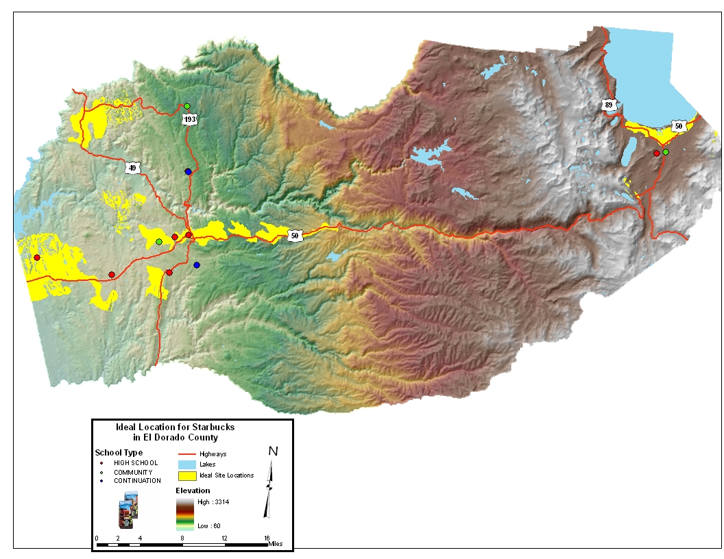
| |
|
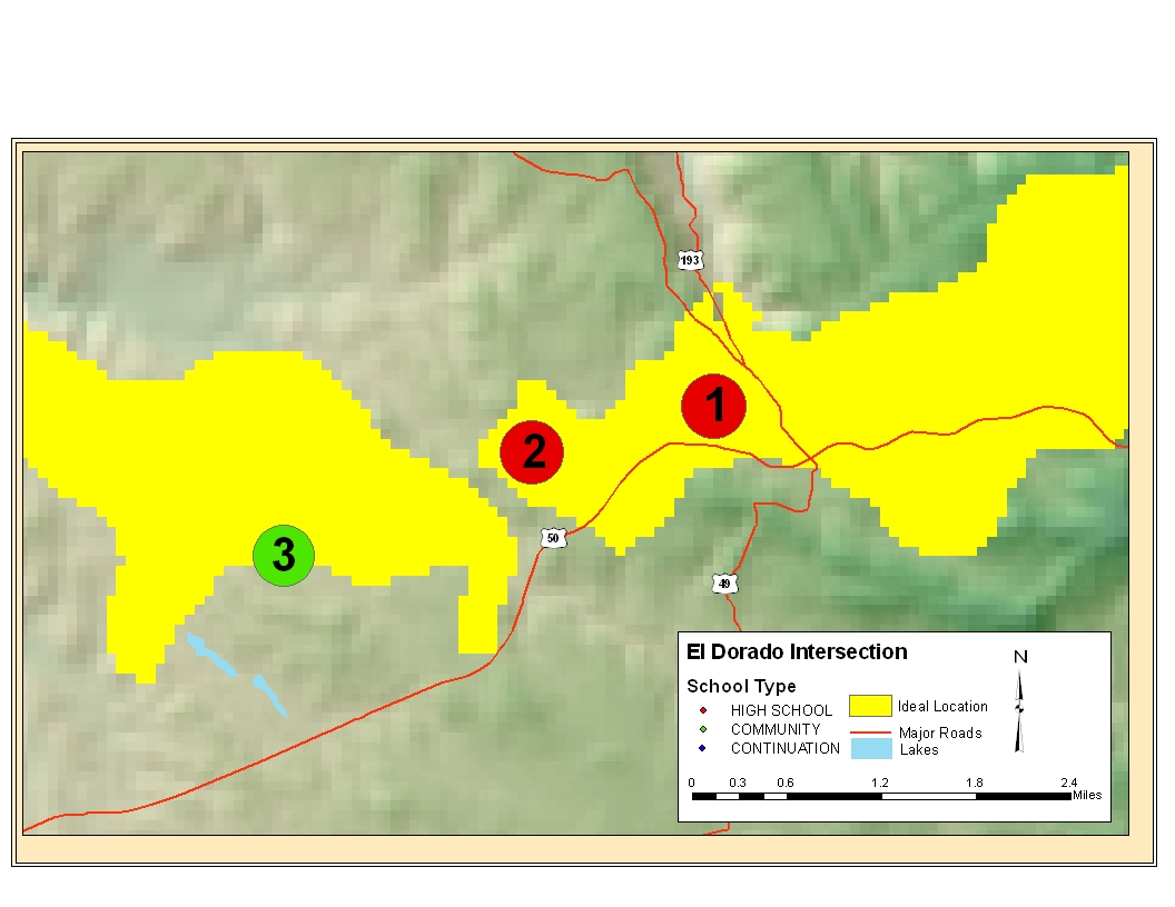
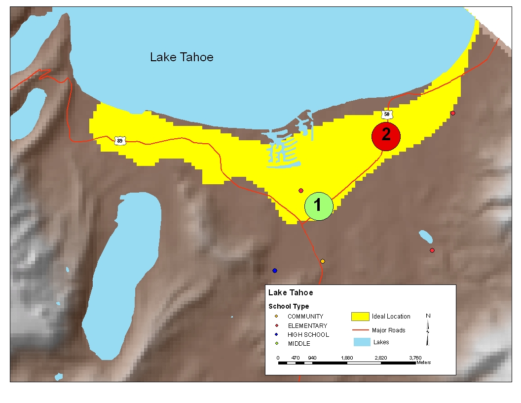
Results The areas on the map that are yellow were all classified as ideal sites. From these areas (yellow on the map) I chose the locations closest to high schools. I then numbered the sites based on which site I considered the best. From County I arrived at two sections that have the highest possibilities. I named them El Dorado Intersection and Lake Tahoe Location.
| |
|
El Dorado Intersection Hwy 50 intersects Hwy 40. Fifty miles north Hwy 40 intersects with Hwy 193.
• Site #1: Is the preferred site due to its proximity to the intersection of two major highways.
• Site #2: Is located approximately 50 miles from the intersection.
• Site #3: Is a community school which attracts a variety of people from within the area.
| |
|
Lake Tahoe Location Lake Tahoe is unique within El Dorado County; it is a major tourist destination. The ideal location requirements in this area vary slightly. Proximity to a major road becomes a higher priority due to tourist traffic.
• Site #1: Is located close to the intersection of Hwy 89 and Hwy 50. It is located within our selected area; however it is an elementary school.
• Site #2: Is located close to Hwy 50 and has a close proximity to Lake Tahoe which would increase tourist traffic.
|
| |
|
Analysis Businesses today are investing a great deal of money in marketing their product or company. In addition there are many companies that find merging with their competitors will increase their monopoly in their field. Doing all of this is very expensive and corporations need to know as soon as possible if their locations will be profitable. GIS is allowing corporations that ability while saving them money. Finding an ideal location for a new Starbucks store in El Dorado County is a practical application of resources and funds.
| |
|
Conclusions Some of the problems encountered while working on the analysis were additional data, time constraints and corrupt data. Projected income in an area would have been a great data layer to use in this project. In addition to the 4 parameters it would have greatly defined the ideal locations. Provided with additional time I would have narrowed the parameters in order to narrow the ideal locations. The first thing I would do is only build in urban or barren areas. This would have greatly reduced the ideal site locations. In addition I would have placed current site locations on the map. This will be done using geocoding in ArcGIS at this time some of the data layers were corrupt.
| |
|
References Derived data, metadata and projection from www.gis.ca.gov updated January 1, 1997
Report by Upstate California - El Dorado County Profile
http://www.co.el-dorado.ca.us/economic/2005profilepdf/Demographics.pdf last updated on Monday, April 18, 2005 1:57 PM
Starbucks company information http://www.starbucks.com/default.asp. Accessed on May 13, 2005.
| |
|
Disclosures Monica Garcia is not an employee of El Dorado County or of Starbucks Corporation. This project was conducted as part of a school project without permission of either entity. | |