Visual Assessment Of The American River Parkway Bluffs Area |
|
|
Author: Patrick Olsen |
|
|
Abstract
There is an ongoing planning effort by several governmental stakeholders overseeing the park's current and future development and maintenance operations. Also, there are political mandates willed by the citizens of California to protect and enhance vital riparian areas. But the results of any planning decisions made at the local level will also have to address the rights of property owners and businesses adjacent to the parkway. One issue in particular that has already arisen in recent years is the construction of large multi-story dwellings on the bluffs overlooking the parkway. Some citizen-users of the park feel that such dwellings are a visual intrusion to it's natural character. Home owners on the other hand, feel that they have a right to enjoy and utilize their property to the fullest Because of the location and scenic backdrop that the parkway provides, real estate prices of these properties are at a premium. Property owners therefore believe that large expensive homes must be constructed to justify the real estate cost. The purpose of this study is to develop a methodology for assessing the current visual quality of the Parkway's scenic resources. This study will provide useful information to decision makers and visual documentation for the general public so that they may better understand the planning issues that are being addressed. |
|
|
Introduction
The visual assessment provides information about the visual condition, character and sensitivity of the existing Parkway corridor throughout it's 29 mile long reach from the Natomas Dam to the confluence of the American and Sacramento Rivers. Flood control issues and natural resource management were the main issues that led to the creation of the American River Parkway Plan in 1985. In 2002 the River Corridor Management Plan (RCMP) was developed as a cooperative effort involving several public stake-holders to protect and manage the parkway's resources in as near-natural condition as possible, thereby preserving it as a perpetual greenbelt and open space. Another objective of this governmental planning effort is to permit and encourage recreational uses of the Parkway which do not conflict with the protection of the Parkway's natural assets. As a tool to better evaluate these objectives the Visual Assessment will provide a basis for public input. It will also provide support for the decision-making process used by local, state, and Federal government agency representatives charged with protecting the resources of the River Parkway. Stake holders include several local governments and not-for-profit organizations.
|
|
|
Background
Visual Quality Classification |
|
| . |
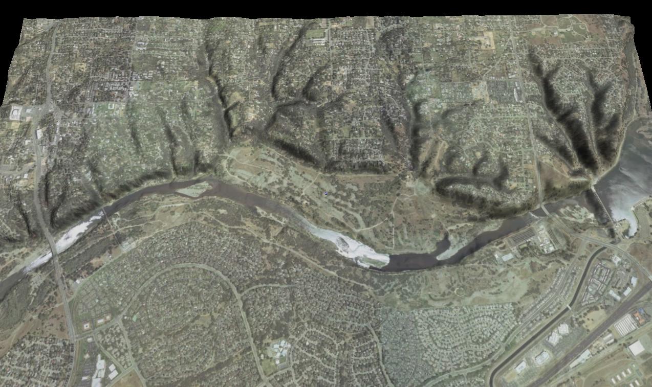
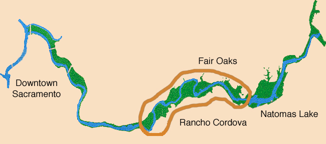 Location of Study Area Location of Study Area |
|
Partial view of study site from Sunrise Boulevard Bridge on left to Natomas Dam on right. | |
|
Methods
Glossary
Data Model |
|
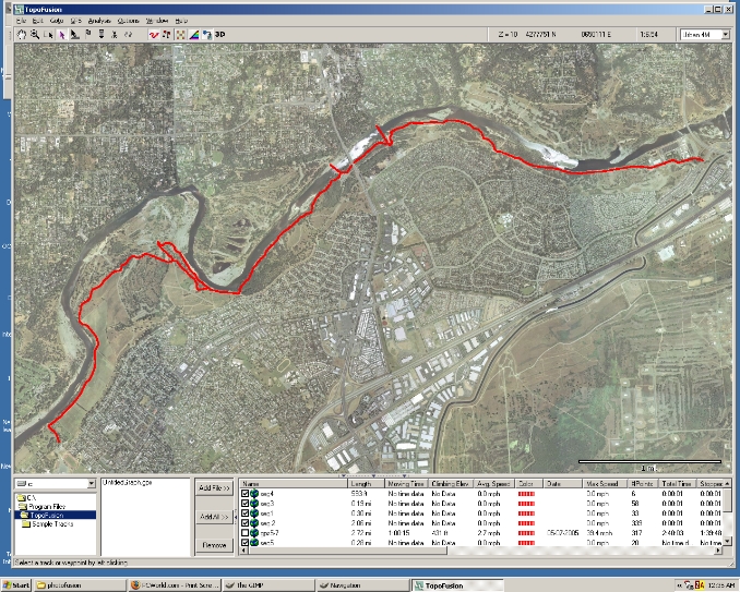 Track from Hagan Park to the Fish Hatchery at Hazel Boulevard | |
|
Results The 3D shaded relief visualization of the bluff area along the north side of the river provides graphic documentation of the topography. To better evaluate the relationship of the bluffs to the parkway trail the elevation model was vertically exaggerated by a factor of 1.5 to 2.5 times. This is a common practice used in graphic procedures because 1:1 representations often are too subtle to be discernable. It is important that this exaggeration is not overdone in such a way that the product misrepresents the real nature of the topography. This methodology can be further developed in order to classify scenic resources in an overall analysis of the Parkway using GIS software. Classifications may include both objective parameters and subjective viewer perceptions. One common classification involves the distance of the scenery from viewer. Values may be created for foreground, middle ground and background scenery. The viewpoints in this study have been determined with this classification in mind so that the data may be incorporated in future studies. Foreground values generally occur at up to about 1/8 mile. This zone may be given a larger weighting value to provide better comparisons between alternatives because effects to the scenery are much more apparent in this immediate foreground zone. Middle ground zones may include areas 1/8 mile to 1 mile from the viewer. Again, the elements in this zone are also more noticeable because of the long views available up and down the river, especially at river bends that allow greater viewing angles . Background zones includes all areas visible beyond 1 mile. For the purposes of this visual assessment, the foreground and middleground areas are of most importance. Background scenery in the context of the American River Parkway is given a low value for a couple of reasons. One, visitors are mostly local residents using the park recreationally and do not expect or even greatly value scenic distant views from the within the park. Also, because of the low lying nature of the river bottom, there are few opportunities to glimpse scenery beyond one mile. Backround scenery values are more relevant in the context of recreational destinations such as wilderness areas, national parks or national forest lands.
| |
 | |
|
Figures and Maps
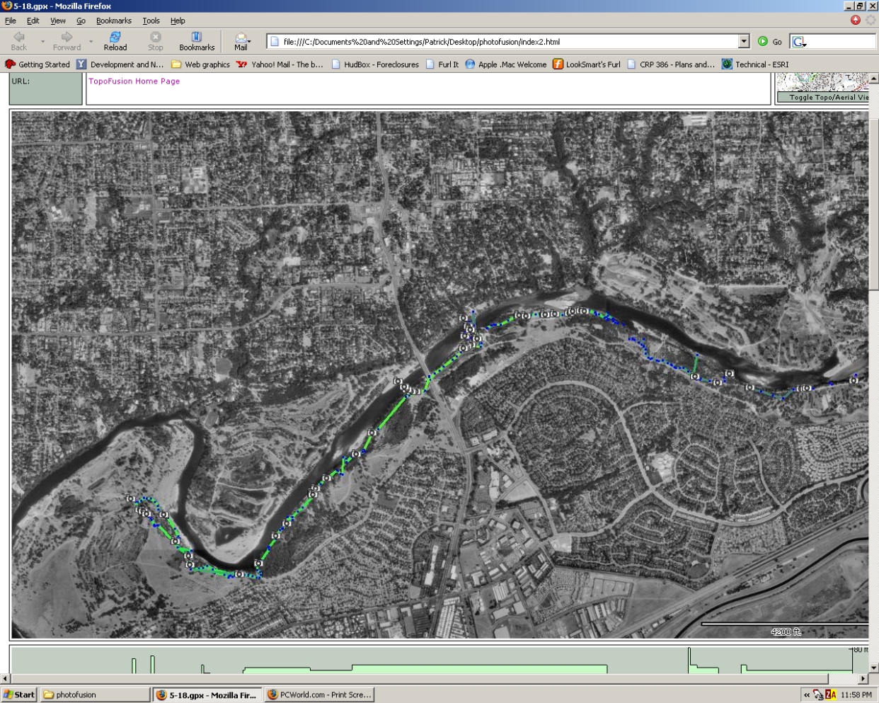 Camera locations on the Trail |
|
|
Analysis
SCENIC RESOURCE MAPPING In order to quantify the visual resource, a mapping inventory of this river stretch was done using spatial modeling software. A three dimensional model including the location of the track and camera viewpoint locations recorded by a GPS handheld unit. Viewpoints and Landmarks Viewpoints are places within the park from which geo-referenced archival photos are taken. Viewpoints are located at regular intervals along the park's main travelway, a 10 foot wide asphalt surfaced walking and bike trail. Photos taken from Viewpoints depict landscape or cultural features that may have either significant visual impact or scenic value. They also document the existing condition of the landscape which may provide an historical reference to future studies.
|
|
|
Conclusions The inventory of existing scenic resources developed here may be used as a beginning point of larger and more detailed studies of the entire stretch of the American River below Natomas Dam. The purpose of this document is to develop a methodology for conducting visual assessments that will aid local decision makers charged with the stewardship of the Park. A concern identified by the public is the visual impact resulting from the development of large multi-story residences along the bluff edge overlooking the river. Further public discussion will be necessary to determine what level of visual impact from adjacent property development will be acceptable. Although designated as a natural corridor, the Parkway requires ongoing maintenance to ensure the health, safety and welfare of it's recreational users. The scenic values produced by the study will be based on the natural character of the corridor and the sensitivity and level of concern/expectations of the Parkway's recreational users. The information gathered in the Visual Assessment will provide a basis for assessing present and future visual impacts resulting from adjacent development. |
|
|
References The National Environmental Policy Act of 1969, as amended (Pub. L. 91-190, 42 U.S.C. 4321-4347, January 1, 1970, as amended by Pub. L. 94-52, July 3, 1975, Pub. L. 94-83, August 9, 1975, and Pub. L. 97-258, § 4(b), Sept. 13, 1982) Ervin H. Zube (1931-2002): The Significance and Impact of His Contributions to Environment-Behavior... Gobster et al. Environment and Behavior.2003; 35: 165-186. Links American River Parkway Foundation http://www.arpf.org/ American River Natural History Association http://www.arnha.org/ American River Parkway Plan Update http://www.saccounty.net/planning/american-river-parkway/american-river-parkway.html Sacramento Area Flood Control Agency http://www.safca.org/ Sacramento County Parks and Recreation http://www.sacparks.net/
Save the American River Association Inc. http://www.sarariverwatch.org/pages/1/index.htm | |
|
Appendices
| |