| Title A Mapping Update of Vegetation in the American River Parkway | |
|
Author
Jeffrey Mallory | |
|
Abstract The American River Parkway is a fantastic diverse greenbelt that traverses through Sacramento. The vegetation in the Parkway was mapped around 1993 but the layer that was produced had inherent errors that needed to be updated. With the use of object oriented spatially based software a segementation process was run to create a new set of polygons for the Parkway encompassing the area maintained be the Sacramento County Department of Parks and Recreation. A regionalization process was the run to populate the new polygons with the existing vegetation data. Manual on screen eediting of vegetation types was done to complete the map. | |
|
Introduction The American River Parkway within the confines Sacramento is a fantastic oasis amoungst the buzzing population. The American River Parkway was purchased by the County of Sacramento as a way to perserve its rich natural habitat and stop urban encroachment. The 5000 acre 23-mile stretch of the American River form the mouth at Discover Park to the Nimbus Dam is managed by the Sacramento County Department of Parks and Recreation. This stretch is home to many resident and migratory birds,several egret rookeries, deer, otters, beavers, and more. The river itself is host to a rich fisheries habitat that includes salmon, trout,steelhead, striper, and shad. Recreational atictivies in the Parway abound with up to 5 million visitors a year enjoying its beauty and grandure. An accuarate and precise vegetation map of the parkway curently does not exist. There is a partial vegetation map that was created sometime around 1993. An updated map with more preicsion will go a long way to help with the management native and non-native species as well as provide for a way to monitor the gain or loss of habitat within the confines of the Parkway. My approach was to create a new set of polygons using 2005 NAIP (National Agriculture Imaging Program) as the base imagery. The existing vegetation data from the Sacramento County Parks and Recreation was then regionalized to the new set of polygons. The existing data was also cross-walked to the the US Forest Sevice Region 5 CALVEG vegetation type which was subseqently cross-walked to the California Wildlife Habitat Relationships (CWHR) system. There was also extensive field work done to idenify vegetation types by polygon that were ultimately used to populate new polygons where data from the existing product does not exist or where new polygons have created a change in vegetatiion type due to the finer precision of the new polygons. Extensive editing of the new database for updates was done to create a fianlized database. Finally a metadata file was created. | |
|
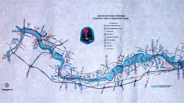
The American River Parkway from Discovery Park to Nimbus Dam. | |
|
Background The American River Parkway was mapped sometime around 1993. The exact date was not know by natural resource specialist, Trevor Burwell, at the Sacramento County Department of Parks and Recreation.To further complicate matters the person who originally did the mappping no longer worked there.The format of the existing map was one of hand delineated polygons saved as a shapefile. I used this as the basis for the map I created, but there were inherent problems that had to be solved before the layer could be of use. When I recieved the shapefile there was no projection file with it and When I brought it into ArcView to view it over imagery the two layers would not allign. The layer is composed of 9700 polygons but 2000 of the polygons did not have data. There was simply an "x" in the field for vegetation type, so the layer was also incomplete. There were vegetation types but no acompanying vegetation descriptions. There also was no metadata file associated with shapefile.
| |
|
Methods Software Used ArcGIS 9.1 Erdas Imagine ARC Command Line AML ArcView 3.3 Definiens eCognition Solving the Projection and Vegetation Descriptions Problems The Segmentation Process | |
|
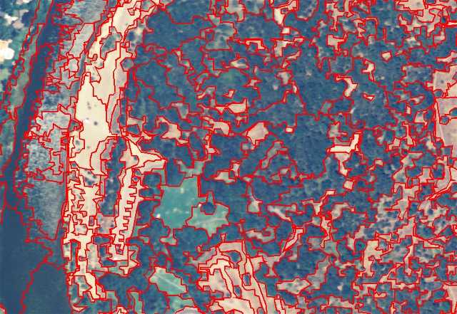
Segmentation polygons over 2005 NAIP imagery | |
|
The Regionalization Process | |
|
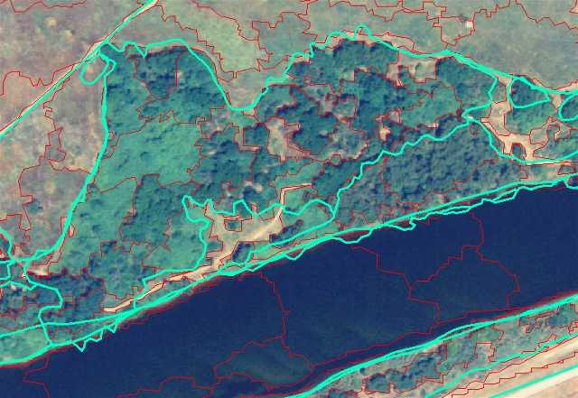
Regionalization--New polygons (red oulines) get the label of the old polygons (green outlines) | |
|
Fieldwork and Editing | |
|
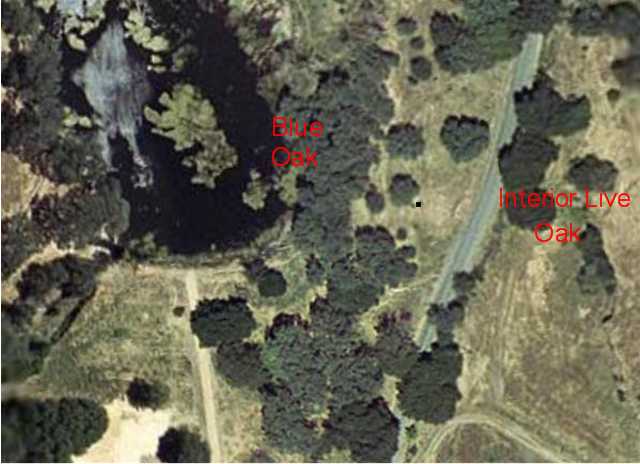
Editing vegetation type from imagery | |
|
Results The segmentation process crated polygons that captured the
spatial distribution of vegetation with much more precision then the origianl vegetation product. The regionalization process
also worked well, but with the finer detail in the polygons there were new polygons that had bad labels.
These labels, along with the unknown labels in the original data, had to be edited on screen to attribute the
correct vegetation type. | |
|
Analysis The origianl sacramento county vegetation layer has 9700 polygons
and the new layer has 13500 polygons. Approximately 3500 polygons now had bad labels because there was a change
in lifeform (ex-old polygons of trees were now a shrub type). Along with the 2000 original polygons that had labels of
unknown vegetation type this made for an intensive manual editing task that was the most time consuming
portion of the process. | |
|
Conclusions The segmention and regionalization processes worked quite well for this project.
The amount of manual editing that had to be done was not originally anticipated to be such a time consuming portion.
An alternate approach in the future might be to do a lifeform edit (ie edit to shrub, hardwood, grass) instead of going straight to the
vegetation type edit. The use a nearest neighbor routine could then be used to populate vegtation type by lifeform. The only
attribute mapped for this project was vegetation type. To be more complete tree diameter and tree crown closure should also be
mapped. CALVEG vegetation type is still being worked on and the cross-walk to WHR still needs to be done. There are also
vegetation communities in the project that did not fall under any current vegetation discriptions and so descriptions of these
types need to be generated. Finally until the above situations are addressed and completed the meatdata file is also currently
incomplete. | |
|
References Burwell, Trevor. Natural Resource Specialist with the Sacramento County
Department of Parks and Recreation Gorden, Hazel. Ecologist at the US Forest Service Remote Sensing Lab Holland, Robert F., 1986. "Preliminary Descriptions of the Terristrial Natural Communitiew of Claifornia." USDA Forest Service - Remote Sensing Lab, Ecosystem Planning http://www.fs.fed.us/r5/rsl/clearinghouse/gis-download.shtml | |