|
US Highway
50 Granite Mile Markers: Travelers' Aids Or Roadside Relics?
Jeanine Phillips
American
River College
Geography 350: Data Acquisition in GIS
Fall 2006
Abstract
This project examines the
relative accuracy of the placement of the historical granite mile
markers located on US Highway 50 from Placerville to South Lake
Tahoe, California, in September and October of 2006. Location
coordinates were recorded with a GPS unit for 32 mile markers while
the distance between each marker was measured with a car odometer.
GPS data were exported to a GIS and overlayed on a routed highway
layer. Distances between each mile marker were determined with the
GIS and compared to the distances obtained with the odometer. The
data obtained with the GPS/GIS and odometer were not significantly
different. The errors in distance between adjacent mile markers were
not significant, however, the amount of error from mile marker 1 to
each of the other markers was cumulative and tended to increase as
distance from mile marker 1 increased. The range of error was 0.2 –
3.5 miles. It is left up to the traveler to decide whether these
errors in relative accuracy are important or of no consequence.
Introduction
US Highway 50 on the western
side of the Sierra Nevada mountain range was originally surveyed
approximately 100 years ago. At that time survey crews placed
granite mile markers on the side of the highway to inform travelers
of the distance west to the town of Placerville . Today, many of the
granite markers still exist on most sections of the highway. New
granite mile markers that mimic the original ones also have been
placed on new sections of Highway 50 which no longer follow the
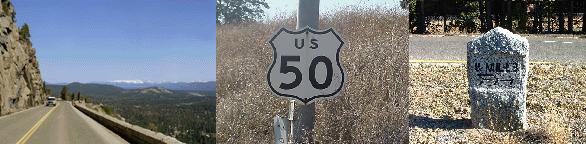
original routes (marker example: top right photo). However, it is
possible and highly probable the granite markers have been moved
since their original installation during highway realignments and
maintenance, snow removal, land slides and other activities (G.
Petershagen, personal communication, 2006).
The goal of this project is
to determine if the granite mile markers are reliable distance marks
to Placerville. The relative accuracy of the current positions of
the markers on Highway 50 and Pony Express Trail between Placerville
and South Lake Tahoe will be assessed using GPS/GIS and compared with
a car odometer data. The distance from the first mile marker to each
of the other markers and the distance between each subsequent marker
will be ascertained. In addition, the relative differences in the
two data collection techniques will be examined.
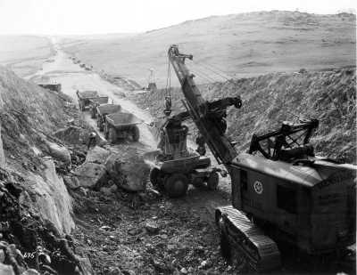
FIGURE
A. Construction of US Highway 50 in the Sierra Nevada in
1940.
Background
In 1895, the California
state legislature designated the Placerville Road as the first state
road and renamed it the Lake Tahoe State Wagon Road. It crossed the
Sierras from Placerville to the California-Nevada state line. The
road remained in disrepair for many years due to lack of state
funding, but funds began trickling in from the state in the early
part of the 20th century. During this time the road was
surveyed in two phases, the first part of the survey was accomplished
in 1900 and the second phase was accomplished in 1907. To mark the
survey, surveyors placed granite mile markers which informed
travelers of the distance to Placerville. The markers were made by
the prisoners at Folsom State Prison. Since at least the gold rush
in the late 1850's, it had been a local tradition for roadhouses,
resorts, small communities and other businesses along the road to be
built at or name themselves according to the distances to
Placerville. For example, 3 Mile House, 5 Mile House, 6 Mile House,
14 Mile House, and 29 Mile Ranger Station are a few of the “original”
names.
In 1923, the first asphalt
was laid on the highway and in 1924, the federal government
designated the Wagon Road as US Highway 50, one of the first highway
systems to span the continental United States (Figure
B). During the 1920's and 1930's highway improvement funds
began to trickle in again and old parts of the road were abandoned
(Figure A). But it
wasn't until 1957 that a portion of the highway in Camino was
expanded to 4 lanes.
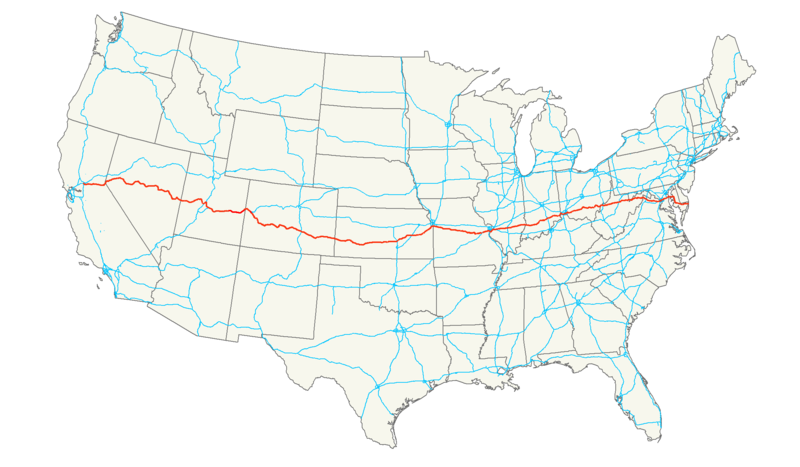
FIGURE
B. Current extent of US Highway 50.
Methods
Data Collection and
Processing
The UTM (NAD83) locations of
all markers that could be located on Highway 50 and Pony Express
Trail while driving a car were recorded as waypoints with a GPS
receiver (Garmin GPSMap 76S). Each position was averaged 50-100
seconds. Odometer readings at each mile marker also were recorded.
Coordinate and distance data were entered into a spreadsheet,
downloaded into ArcMap (ArcView 9.1) and exported to a shapefile. A
Caltrans highway layer was downloaded into ArcMap and routed with the
Create Routes tool in the Linear Referencing toolset in ArcToolbox.
The location of each mile marker on the highway was calculated with
the Locate Features Along Routes tool. The distance data were
exported to a spreadsheet and converted to miles. Errors in distance
from mile marker 1 and each of the other markers were calculated
(1-GPS/GIS distance) for Highway 50 markers only. Mile marker 1 was
used instead of mile 0 (old Placerville City Hall steps) because the
route the original survey crew took from mile 0 to mile 1 was
unknown.
Analysis
Data were tested for normal
distribution and analyzed by two-tailed t-test
or paired t-test to
delineate significant differences. Level of significance for both
tests were set at P <
0.05. Statistical tests were performed using JMP IN (v4.0.2)
software (SAS Institute, Inc.).
Results
Data Collection
Not all
mile markers could be located. Markers 1-4, 8, 15-16, 18, 21-27,
30-37, 40-42, 45-49, 51-52 and 56 were located on Highway 50 and
markers 9-13 were located on Pony Express Trail (Figure
C).
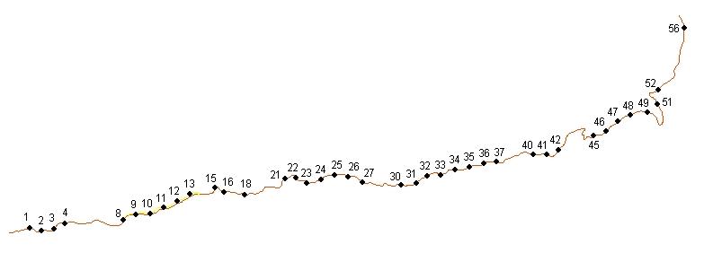
FIGURE
C. Map depicting locations of mile markers on US Highway 50
and Pony Express Trail collected with a GPS.
There
appeared to be approximately 3 different styles of lettering and
symbology on the markers (Figure
D), and location did not appear to be a factor in the type of
style or condition of the mile marker.
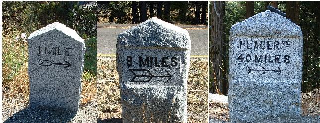
FIGURE
D. Photo depicts 3 different styles of mile marker.
All
markers were on the south side of Highway 50 or Pony Express Trail,
and the majority of markers seemed to be located in areas with wide
highway shoulders, although this was not the case on Pony Express
Trail. Thus markers may have been placed opportunistically possibly
for ease of maintenance or increased visibility to travelers.
Analysis
Data
were not normally distributed, but since the data distributions were
approximately normal and t-tests are relatively robust to
violations of this assumption, the data were analyzed with parametric
tests where appropriate. There was a 0.35 percent difference in mean
measurements obtained with a GPS/GIS and odometer, but the means were
not significantly different (paired t-test, t = -0.2403, P
= 0.8116). A graph of the absolute errors in distances between mile
marker 1 and each of the other mile markers (Figure
E) revealed a lack of independence of each location from the
others, i.e., errors in distance were cumulative, thus the data were
not tested for significant differences. Absolute errors in distance
ranged from 0.2 miles at mile marker 2 to 3.5 miles at mile marker
42.
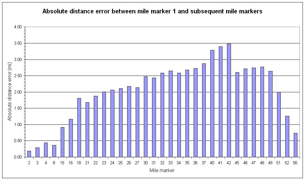
FIGURE
E. The absolute errors in distance between mile marker 1 and
each subsequent marker were cumulative in most cases.
The
distances between adjacent mile markers were not significantly
greater or less than 1 mile on Highway 50 (t-test, t =
-0.5992, P = 0.5534, mean = 0.98 miles) (Figure
F) nor on Pony Express Trail (t-test, t =
-0.7369, P = 0.4667, mean = 0.97 miles) (data not shown).
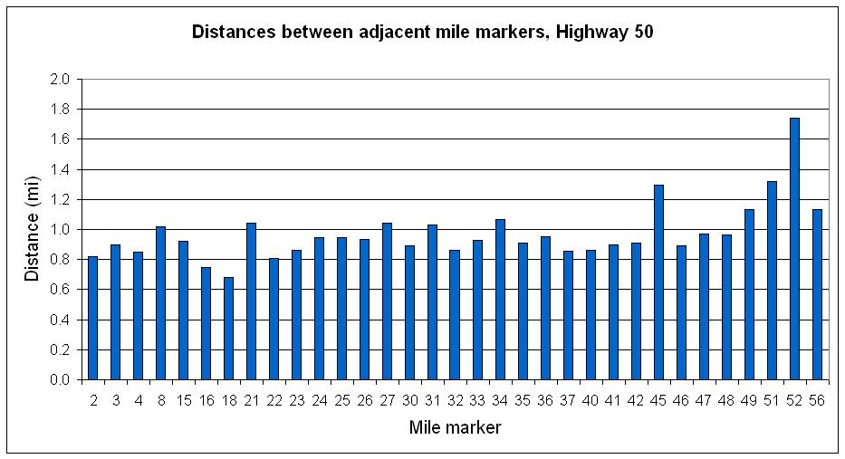
FIGURE
F. Distances between adjacent mile markers. For example, the
total distance between markers 18 and 21 is > 1 mile, but has been
divided by 3 to find the average distance of 1 mile.
Conclusion
The
locations of the granite mile markers on Highway 50 are inaccurate
and exhibit location errors of 0.2 – 3.5 miles. Due to the
accumulation of errors in distance from marker 1 to each of the other
markers and the fact that distances between adjacent markers were not
significantly greater or less than 1 mile, it can be assumed that
modern day workers who replaced the markers chose placement locations
by calculating the distance from the preceding marker and not marker
1 (or mile 0 at the old Placerville City Hall). It's also possible
the errors may be due to changes in highway alignment or the
abandonment of certain stretches of highway. Route changes could
easily shorten or lengthen the highway. If these errors existed
during the early days when wagon teams and the first automobiles
routinely crossed the Sierra and likely traveled at an average rate
of 4 miles per hour, the errors probably would have been more of an
issue. However, today's travelers enjoy advanced and more speedy
forms of travel relative to those of 100 years ago, so it would be
difficult to determine if the inaccuracies of the markers are an
inconvenience or annoyance. It will be left up to the individual
traveler to decide whether the marker errors in relative accuracy
render them roadside relics or whether they can still be considered
travelers' aids.
References
Caltrans photographs obtained from
http://www.dot.ca.gov/hq/LandArch/scenic_highways/index.htm.
Site accessed 12/20/06.
Donaldson RL. 1974. The Placerville
Road. Manuscript. San Mateo, California.
Petershagen GF. 1990. Locations of Historic Roadhouses Along US 50.
California Department of Transportation. Sacramento, California.
|