| Title The Continuing Price We Must Pay For Our Land | |
|
Author Name: Mark Dennehy American River College, Geography 350: Data Acquisition; Spring 2007 Mark "Mad Dog" Dennehy trifling@sbcglobal.net | |
|
Abstract Today, many residents of California's Central Valley are living unaware that the flood control system designed to protect them may fail without notice. A failure of the flood control system would result in one or more floods in the Central Valley. We are also living at a time when a shift in global temperatures may result in a substantial sea level rise. This event would cause a great flood in the Central Valley. Considering these two factors in modern times may compel the resident of California's Central Valley to take a good look at our current flood control system. Is it adequate? Can it adapt? Are we Central Californians prepared to face the reality of the price that we will have to pay to keep the land that we have settled? | |
|
Introduction Many people live in the California Central Valley. Some may not be aware that they are living in a floodplain. Some may have false beliefs concerning the possibility that a flood event will occur in their community, and some may not understand the level of devastation that flooding can inflict upon them. Flood management policy is a work in progress. Only since the 1997 flood events, when 48 of California’s 58 counties experienced serious flood events, did the State of California really ‘wake-up” to the economic and social consequences of flood. Presently there is a significant amount of developmental pressure to build in areas that are subject to flood. This may be partially due to a relatively recent court judgment which places liability upon the State of California should a flood event occur. This paper will estimate graphically how many people in San Joaquin County, California are living in harms way because of the possibility of flood. Innundation will be demonstrated to 8.5 feet elevation, which is the Base Flood Elevation at the Calaveras River where it meets the San Joaquin Delta. This location is centrally placed in San Joaquin County. This paper will also explore current flood management policy for California. | |
|
Background | |
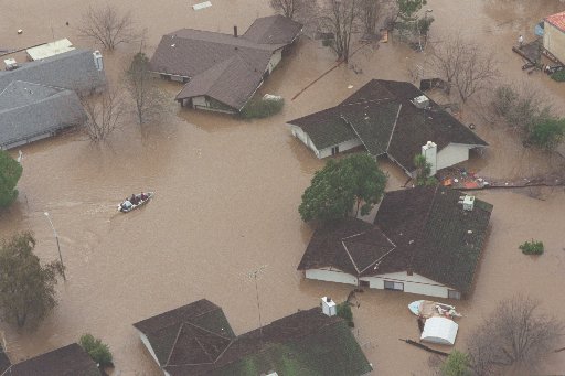
| The flood control system in California's Central Valley is made up of 1600 miles of project levees, reserviors that include detention space, and bypass channels. They were constructed for or brought into a Federal flood control project and turned over to State agencies for operation and maintenance (Flood Warnings, page 6).These levees are considered project levees. The State of California's flood control system releases water through the Sacramento-San Joaquin Delta. This delta has over 1000 miles of local levees. A local levee is considered a non-project levee and is most likely maintained by a reclamation district. The Department of Water Resources inventories and maintains all project levees that have been turned over to the State of California (Flood Warnings, page 6). Perhaps the driving force behind present day flood management policy in California is the Paterno Decision that was upheld by the Third Court of Appeal in November 2003. In this decision the State of California was found liable for economic damages resulting from the Linda levee failure on February 20, 1986. In this decision the idea of "inverse liability" as a matter of law (Court Decision) was cited as the basis for the finding of liability. Inverse liability as it applies in this case means that if a public agency runs a flood control system that was built by another party, that it also assumes liability if a levee that is a part of that system fails (Flood Warnings, page 9). The Paterno decision was affirmed in November 2003, six years after the flood event of January 1997, which is considered by far the most costly flood event in California's recorded history. Forty-eight of California's Fifty-eight counties were declared disaster areas, nine people died, and 120,000 more people were evacuated. During these floods, a total of 300 square miles was innundated, causing at least 2 billion dollars in damages, and having an eventual indirect economic cost to the economy of California of approximately 5 billion dollars(Flood Map Modernization, page 2). In 2002 in another court decision, Aarreola v. Monterey County, local government bodies were found liable for the damages resulting from a 1995 flood for failing to maintain a levee, even though those government agencies were unable to use modern mechanical equipment to clear riparian vegetation. The modern mechanical equipment would have destroyed protected habitat along the levee. It turned out to be too expensive to use methods of vegetation clearing that would not have destroyed riparian habitat(Flood Warnings, page 9-10).The photo to the right is of Roseville during the January 1997 flood event that rocked the State of California. |
|
|
Methods | |
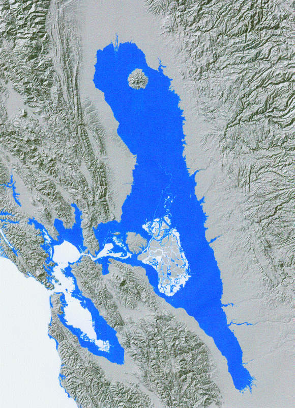
| Take a close look at the map to the right. This map shows Northern California inundated with sea water to an elevation of 80 feet. It is understandable if one's first thought is disbelief. However, this is what Central California might look like if the glacier ice sheets in Greenland and Antartica melt due to the effects of global warming. An 80 foot rise in sea levels is not a mainstream prediction of the one of the long term effects of global warming, but it is interesting to visualize the possibility of a great sea level rise especially since that condition has existed at some point in the past. According to the California Coastal Commission (Sea Level Rise page 4), there is evidence that in the past sea levels have risen approximately 100 feet above their current level following the last ice age. Lets say for the purpose of argument that the total volume of water in all its forms, ice, liquid water, and steam remains constant on earth. At the present time we earth dwellers have water stored as glacier ice primarily in Greenland and Antartica. Therefore if all the glacier ice melts, sea levels may rise to at least 100 feet or more above where they are today, being that most water on earth would be present in its liquid form. So my map really is not a left-field hype. Its not even a worst case scenario. Although my presentation is not about the effects of global warming, I wanted to include it to show the possible geographic shape of Central California in the not too distant future and with this in mind take a look at the present flood control system in Central California. community. |
|
|
Results According to the 2005 estimates U.S. Census, there are approximately 564,000 people in San Joaquin County. The lastest Flood Insurance Rate Maps, published by FEMA, the Base Flood Elevation for San Joaquin County is 8.2 feet at the point where the Calaveras River meets the San Joaquin River. The map of San Joaquin County below shows the Interstate 5 corridor and the adjacent economy in San Joaquin County is at or below 8.2 feet. 8.2 feet is the Base Flood Elevation at the Calaveras River which is located at approximately the center of San Joaquin County. If San Joaquin County were to become flooded to this level, it would spell economic disaster on an very large scale. Also some people might get hurt. One might ask why people would choose to make their lives in harm's way. Well the answer is two-fold. First, many people assume that their communities are built out of harm's way or that the levees that they live behind will not fail (Flood Warnings, page 9). This frame of mind may be ingrained in the mind of Western man because of his Biblical roots, "Go Forth And Multiply". When these words were spoken, man in his relationship to habitable land on earth was an idea without limit. This is not to say that those spoken words are no longer valid because the idea of habitable land without limit is cetainly still a possibility if one takes into account the idea of habitable worlds in space. But for the present time, according to Paul Bolstad (GIS Fundamentals page 456), "Land scarcity has led humans to build in low-lying areas". Further he states that "population pressures have driven farms, cities, and other human developments into flood-prone areas, and the same developments have increased the speed and amount of rainfall runoff, thereby increasing flood frequency and severity." | |
|
Figures and Maps | |
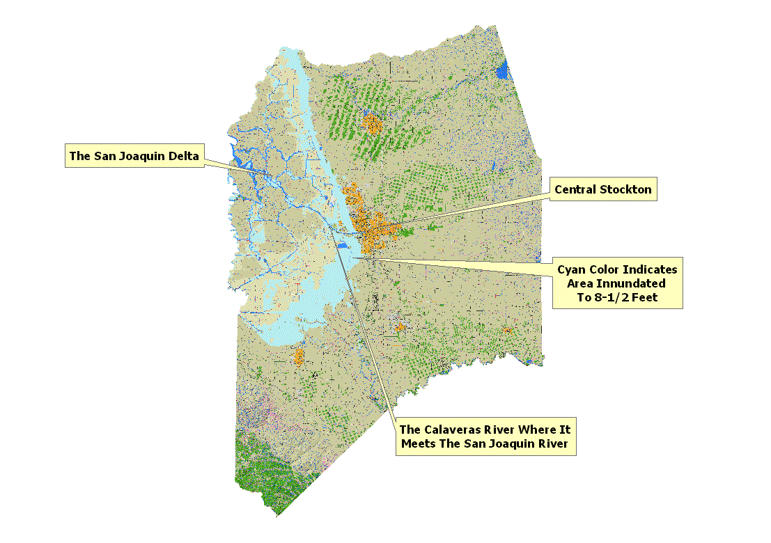 |
San Joaquin County as it would look if it were flooded to 8.5 ft. The flooded area appears in cyan color and covers an area populated by residences and businesses. Certain area in the San Joaquin Delta do not appear flooded. This is due to the lack of elevation data in this area. The Delta would be included in this map in an inundated condition had elevation data been available. |
|
Analysis After the great flood event of 1997 and the ongoing legal battle over Paterno that culminated in an affirmation of Paterno in 2003, it seemed that the public management of flood issues shifted gears. According to the Department of Water Resources, The Governer of California put together a group called FEAT(Flood Map Modernization, page 5). FEAT stands for Flood Emergency Action Team and their task was to take a look at the State's requirements in dealing with possibile future flood events. Senate bill 4 was passed to assist in this matter. This bill gave the Department of Water Resources, also known as DWR, a yearly budget for the purpose of floodplain mapping (Flood Map Modernization, page 5). Further in 2002, DWR was directed to begin a Floodplain Management Task Force(Flood Map Modernization, page 5). The purpose of the Task force was to devise methods for the reduction of losses due to floods.There are however obstacles to effective flood control management in California. The primary obstacle to effective flood control management in California is money. As far as responsibility is concerned, the Paterno decision effectively put the onus on the State of California. The bottom line for the State is that it will be held responsibile for most levee failures. Complicating this issue is the passage of Proposition 218 which states that 2/3 of land owners in Reclamation Districts must approve all increases in assessments. This proposition, along with Proposition 13, has drastically reduced local governments' ability to generate revenue. Also the Federal government has reduced its share of funding for flood control projects to 65% from 75%(Flood Map Modernization, page 5).The Department of Water Resources says that the state of the flood control system in the California Central Valley is consistently getting worse while at the same time developers are building residential and commercial centers in the flood plain. According to the Department of Water Resources, local agencies have become frustrated because of the roadblocks encountered when attempting to generate revenues for the maintenance of the levees, such as the recently enacted Proposition 218 which requires that new assessments gain a two-thirds approval by voters. The Department of Water Resources also referred to a 2003 court decision, "Paterno vs. the State of California, that held the State of California liable for flood damage after a levee failure. The combination of these laws, court decisions and mindset of the public, which basically amounts to an attitude of unwillingness to pay for levee maintainance when the State and local governments will untimately be held responsible for damages is contributing to the deterioration of the State of California's Central Valley Flood Control System (Flood Warnings, page 12). The Department of Water Resources also cited another issue that is adding to the difficulty of maintaining the levee system to accepatable standards. This issue is that of the competing visions of certain groups of agencies. In one case, one group of agencies is attempting to keep the Central Valley levee system from further deterioration while another group of agencies is attempting to preserve and restore animal and plant habitats along the levees and in the adjoining waterways (Flood Warnings, page 9-10). In another case, one group of agencies is making land use use decisions and another group is being held responsible for poor land use decisions(Flood Warnings, page 8). The Department of Water Resources makes several recommendations to resolve these problems. First is the recommendation that certain State Consitutional and legislative changes be enacted so that a foundation for furthur actions can begin (Flood Warnings, page 19). Also recommended is the creation of a statewide flood insurance plan, a fund that would be brought into line with the National Flood Insurance Program. This insurance plan would require all parcels that affect the drainage basin or that would be affected by flooding, inclusive of all levels of current flood protection, to purchase flood insurance(Flood Warnings, page 17). The Department of Water Resources also recommended the creation of one, two, or three regional Central Valley flood control assessment districts that would be given the power to assess those parcels that are subject to flooding. These assessment districts would have to be freed from the two-thirds voter approval requirement of Proposition 218 (Flood Warnings, page 18). The Department of Water Resources also recommended that flood control projects be indemnified against the "inverse liability" legal concept used successfully in the "Paterno vs. the State of California legal decision. It was further recommended that local flood control projects be relieved of the two-thirds voter approval requirement of Proposition 218 (Flood Warnings, page 19). Other recommendations by the Department of Water Resources include improving maintenance programs in existing infrastucture, the evaluation of the facilities of existing flood control projects with the purpose of determining their cost/benefit ratio(Flood Warnings, page 15), making better the readiness of emergency response programs(Flood Warnings, page 15-16), and the creation of a maintained flood management programs fund(Flood Warnings, page 16). There are, however, some some bright spots in California's effort to manage flood control. Billions of dollars in bonds have been appoved by the voters in California in November 2006 for maintenance, repair, and rehabilitation of levees, and a California Levee Database has been constructed that has been hailed as state of the art (Stormwater).The California DWR Levee Database project is a database supported by a GIS. This levee database project allows DWR to more effectively manage flood control because 14,000 miles of internal waterways including levees, canals, and other flood control features were spatially located with an extensive list of appropriate attributes. USGS Quads and geo-referenced FEMA FIRM's were the basis for spatial location of the flood control features. Another source of levee-related data are base maps that provide the centerlines of levees. The base maps include the following datasets; National Hydrology Dataset stream centerlines, United States Geological Survey (USGS) 1:24000 quad Digital Raster Graphs (DRGs), United States Geological Survey Digital OrthoQuads (DOQs), and Federal Emergency Mangement Agency (FEMA) Flood Insurance Rate Maps (FIRMs). The DRGs and FIRMs were used to digitize the levee alignments. The DOQs were used as a check on the spatial location of the levees. There are also layers on the base maps that include political boundaries such as California Assembly and Senate districts, U.S. Congressional Districts, Counties, Reclamation Districts, maintenance districts, and flood control districts. These base maps are available at the CAlifornia Spatial Information Library (CASIL) (Stormwater). | |
|
Conclusions Flood management is a complex issue. There are many diverse interests who are directly involved or will ultimately be involved in what amounts to a huge fight over water rights, which existed long before the idea of emergency flood mangement, and the corrresponding responsibilities. This paper barely scratches the surface of the water issues that we Californians face today. The costs for maintaining and upgrading levees, as well as the need for new flood control projects will be enormous. A friend of mine even quipped that the land may be worth less than the costs to keep it. Thus the reluctance to begin the very necessary and painful restoration of our flood control system. However if we do nothing, or fail to do enough, we California Central Valley dwellers may become an historical note. | |
|
References GIS Fundamentals 2nd Edition, Paul Bolstad, Eider Press, 2005 Overview Of Sea Level Rise And Some Implications For Coastal California (01/06/01) (1.44M) California Coastal Commission Floodplain Map Modernization State Business Plan (05/04) (738K) Department of Water Resources Flood Warnings(01/10/05) (1.44M) Department of Water Resources Cataloging California's River Levee System Ricardo Pineda & Gary Yagade; Stormwater, the Journal For Surface Water Quality Professionals May 2007 Third Appellate District Court of Appeal Opinion(11/26/03) (180K .pdf) County Population Estimates-Characteristics (07/01/2005) (797K) U.S. Census Bureau | |