| Title Assessing the Effects of the Folsom-Nimbus System on Geomorphic Features and Habitat within the Lower American River, CA | ||||||||||||||||
|
Author Emily Sharp American River College Geography 350: Data Acquisition in GIS; Spring 2007 Contact Information: emily@surewest.net | ||||||||||||||||
|
Abstract Dams reduce variability in habitat, lower peak flows, trap sediment and block fish migrations, but they are necessary for hydropower, water storage and flood control. The American River is heavily damned and controlled, and the largest project on the river is the Folsom-Natoma system. It was hypothesized that the Folsom-Natoma system is trapping sediment and the river has changed in response to that by decreased deposition and formations. This in turn would be negatively affecting habitat and geomorphic structure. Historical and current maps, aerial photographs, field observations and literature research were used as data in this investigation. It was determined that the dam system is effectively trapping gravel sediment and Salmon habitat is suffering from the lack of proper spawning sediments (gravel). The construction of the dams alone caused inundation of creek confluences and the need for mass amounts of dredging. All the dredge tailings then filled in the surrounding landscape, smoothing topography. | ||||||||||||||||
|
Introduction The Purpose of this investigation is to discover the changes in this river segment through time as the Folsom-Natoma system was constructed, and to determine the effects it has had on the maintenance of habitat and geomorphic features downstream. Literature research, geologic maps, historical and current topographic maps, aerial images in stereo, field observations and Google Earth were used in this study to provide the enough data to get an idea of the sediment and topographical changes that have occurred in this river segment. Sediment is what river forms are made of, but is also critical for habitat maintenance. Change in topography will reflect river and land use changes as well. There is interest in doing this project because I live near the American River and reap the benefits of the flood control it provides. If a dam traps sediment, then it decreases its water holding capacity. Also, my husband and I fish this river, so it is interesting to be able to go out and evaluate it for yourself and to know its history. Since rivers are constantly changing and searching to find equilibrium, historical data is vital in order for there to be any understanding of change. The hypothesis is that the Folsom-Natoma system is trapping sediment and the river has changed in response to that by decreased deposition and formations. | ||||||||||||||||
|
Background California has developed the largest water engineering system in the world, and in doing so has damned nearly all the rivers (Mount, 1995). As a consequence, the unforeseen effects of damning rivers have scarred natural landscapes and ecosystems. Besides the problems associated with reservoir management, destruction of habitat for migratory fishes, loss of variability in channel habitats and sedimentation behind dams are some of the more common consequences of damning rivers (Goodwin and Falte, 2000). The magnitude of change seen within a river is dependant upon the extent of change in flow and sediment supply (Mount, 1995). Reservoirs effectively trap sediment, retaining as much as 90% the total sediment load and the entire course fraction load, deposition within can considerably reduce the storage capacity and life expectancy of them while negatively affecting downstream geomorphology (Knighton, 1998).
In downstream reaches, peak flows and bankfull pulses help maintain a level of disturbance in the system. Without variability and upstream sediment supply, processes of bed substrate coarsening (armoring), altering hydrographs, and stabilizing bedforms become common, and establishment of vegetation becomes very difficult (Knighton 1998; Goodwin and Falte, 2000). Bed coarsening, or armoring, occurs as smaller sediment gets transported downstream without replacement from upstream (Kondolf, 1997). Releasing sediment-free water results in progressive, downstream degradation and slope flattening. Upstream, the effects of damning are raised base-levels, aggrading backwaters, and progressive upstream degradation. As water enters the reservoir, transport capacity is lost and a depositional wedge forms, lowering local channel gradients (Knighton, 1998; Goodwin and Falte, 2000). Many dams do pose environmental threats, but most dams were built during a different era when hydropower, irrigation and flood storage were the only concerns during construction. However, if the dam is large enough and engineering allows for sediment passage and rapid flow changes then it may regionally provide many benefits and extensive economic prosperity, while allowing for the complexities of a functional and healthy ecosystem (FOR, 2005; Williams, 2001). The American River, a wild and scenic river in California, is utilized by migratory fish species, such as the Pacific lamprey (Lampetra tridentata) and Chinook salmon (Oncorhynchus tshawytscha), but is also damned in multiple places. Historically, these fish had access to over 161 miles of habitat, annual peak flows occurred in spring and 2-3 runs of spawning fish visited the river per year. Now, peak flows are in early winter and fish passage is blocked by the Nimbus Dam at Lake Natoma, hence the need for the Nimbus Fish Hatchery and habitat has been cut to 23 miles. Besides migratory challenges, spawning habitat has been degraded from loss of course grained sediment inputs (Vyverberg, 1999; Williams, 2001). Studies done by Kris Vyverberg have shown that bed composition in the Lower American has made spawning near impossible. Loss of sediment inputs may be reflected in the channel morphology as a loss of geomorphic formations, armored beds, high erosion with limited deposition. | ||||||||||||||||
| For information on issues, organizations, rafting and streamflow on the American River visit
The American River.
For more information on Salmon, visit the US Fish and Wildlife Service's Anadromous Fish Restoration Program website. | ||||||||||||||||
|
Methods Current and historical Folsom (1967,1954,1941), Auburn (1981, 1953, 1944), Sacramento (1914 and 1929) and Pilot Hill (1973, 1954) quadrangle topographic maps (scale 1:24,000) were used to document changes in the river channel, bars and topography in the North Fork and Lower American River. USGS topographic maps were collected from Shields Library at UC Davis and via the internet from www.TopoZone.com (scales 1:24,000 and 1:200,000, with UTM Zone 10 NAD83 Datum projection). Project sites were chosen based on access and location relative to the Folsom-Natoma system, using a combination of topographic maps, city maps, and Google Earth images. Aerial photographs and stereo imagery were used to make observations as well and those too were obtained from Shields Library at UC Davis. A Garmin Vista Legend GPS unit was used to get coordinates for the sites. The Geology of the American River was documented from literature review and geologic maps of California. Literature reviews also provided information about the system and land uses, but field observations were documented as well. Sediment and particle size data was gathered to enforce observations. Two sites were visited, the North Fork American and Lower American River, where pictures and observations were taken. Changes in land use and impacts, channel shape, bedforms, deposition and sediment were documented and used in conjunction with aerial photos to assess the differences within the system above and below the Folsom-Nimbus project. The North Fork was accessed via the Cardiac Trail near Maidu Dr. in Auburn, CA. The Lower American was accessed below Nimbus Dam at the fish hatchery and observations were made from the American River Parkway. Sailor Bar in the Lower American and the Oregon Bar-North Fork Ditch stretch in the North Fork American were the points of interest for field observations. Conclusions were based on the visual and documented changes within the channel at these two sites, taking into consideration recent restoration efforts and land uses. | ||||||||||||||||
|
Results The image of site1 (Figure 1) shows Knickerbocker canyon, Oregon Bar and the North Fork Ditch. Between the images acquired and the field observations of this site, it was obvious that this stretch of the river has high gradient riffle-pool sequences with deposition on the inside of the North Fork Ditch meander bends and within the Oregon Bar riffles. The tributary draining Knickerbocker Canyon exhibited steep plunge-pool sequences with long waterfalls. The gravel mining operation just upstream of this site is removing cobble and gravel sized sediment from the river (Figure 1a). However, downstream from the gravel mine the river has some sand and gravel deposited in meanders, but much of the sediment is cobbles and boulders. On the Bar below the mine there has been gravel laid down recently. By comparing the Auburn 1944 (Figure 1b) and 1953 (Figure 1c) topographic maps and aerial images with those from 1981, it seems since the mine’s construction the channel widened and less instream deposition occurred. The aerial image of Site 2 (Figure 2) shows Lake Natoma and Nimbus Dam. The Fish Hatchery can be seen on the South side of the river below the dam. Figure 2b shows a salmon carcass at Sailor Bar; the fall run of Chinook salmon is spawn in this area even though the bar and bed are armored with large cobbles, gravel is nearly absent from the system (Figure 2a), but fine grained material is common in downstream deposits. Sandy deposits were seen prior to Sunrise Blvd. but past Sacramento and Sailor Bars. The matrix of Sailor and Sacramento Bars consists of cobbles filled in with and covering sand. These bars were observed because of available particle size data and location. Folsom quadrangles (Figure 2b) from 1941 (just prior project construction) 1954, and 1967 were compared and it has been concluded that before project completion the stream was narrower, the site of the fishery was a huge gravel bar; there was an instream bar deposition near Mississippi Bar, but that has since been inundated by Lake Natoma. There was also more topographic variation within channel. Comparing the 1954 map with the 1914 map showed the original topography of the Lower American prior to major impacts and urbanization. There were no dredge tailings across from Sailor Bar, so the topographic variation of the original system was obvious; however much different from today. In 1914, there were depositional bars at the confluence with Alder Creek, but since then the creek has been diverted away and back again only to feed into the lake. Now the area is covered in dredge tailings and the confluence at Alder Creek has been inundated. In Figure 2c, it is shown what the region currently looks like. The Lower and North Fork American reaches are both single channel, meandering rivers with riffle-pools sequences and techtonic influences. Gravel and gold mining upstream with hydropower and urbanization downstream are the largest land uses within those reaches. Site 1 is antecedent and higher gradient than the Site 2, and the sediment sources in these two reaches differ as well (Table 1). | ||||||||||||||||
Site1: North Fork American River (N38.86963, W121.05286) (Left Top Image) Observations were made near Auburn, CA in Placer County, from Knickerbocker Canyon to the beginning of the North Fork Ditch. Flows in the North Fork are regulated by the North Fork Dam at Lake Clementine. Below the dam, a gravel mining operation removes considerable amounts of cobble to sand size material from this antecedent river. Notice the new addtion of gravel at Oregon Bar, just below the mine. The native rocks were mainly metamorphosed from deep-ocean sedimentary and volcanic materials (Hill, 1985). Site 2: Lower American River (N38.63617, W121.24546) (Left Bottom Image) Observations were made near Fair Oaks, CA in Sacramento County below Nimbus Dam at Sailor Bar. This stretch of river is now undergoing rapid erosion as a result of the gold mining era, dams and land uses. The Folsom-Nimbus system, constructed in 1955, is part of the Central Valley Project and is responsible for regional flood control, hydropower, storage and supply of water. Gold mining upstream inundated the river with 257 million cubic yards of gravel, sand, silt and debris. A range of 5-30 ft. of deposition occurred in the Lower American from Nimbus dam to the mouth, but since then it is commonly believed that the river has incised back down to its original bed elevation (Horner, 2005, Williams, 2001). 23 miles of river lies between Nimbus Dam and the mouth, within this stretch, bed particle size decreases from cobble to finer grains rather abruptly; however large pools separated by steeper reaches are still apparent (Williams, 2001). Nevertheless, at Sailor Bar, river gravel is thin and the general environment in the narrow, high-velocity channel is erosional rather than depositional (Horner, 2005). Downstream, at Sacramento Bar, grain size is coarser through the riffles and glides, but sandy is common. Cobbles of 10 – 20 cm in diameter are the most common grain size, and from the surface, the bar appears structureless. Cobbles make up at least 95% of the material, with sand content increasing offshore from the point bar (Horner, 2005). |
 Figure 1 Figure 1
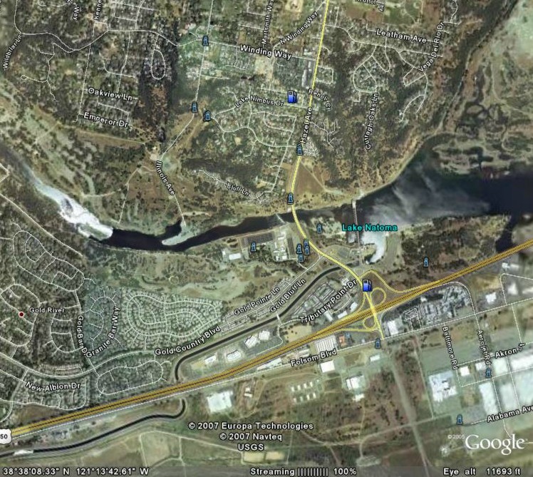 Figure 2 Figure 2
|
|||||||||||||||
| ||||||||||||||||
|
Figures and Maps
 Figure 1a: Gravel Mine  Figure 1b: Historical USGS Auburn Quadrangle (1944) The North Fork American River: North Fork Ditch, Oregon Bar and Kickerbocker Canyon pre-dam construction. 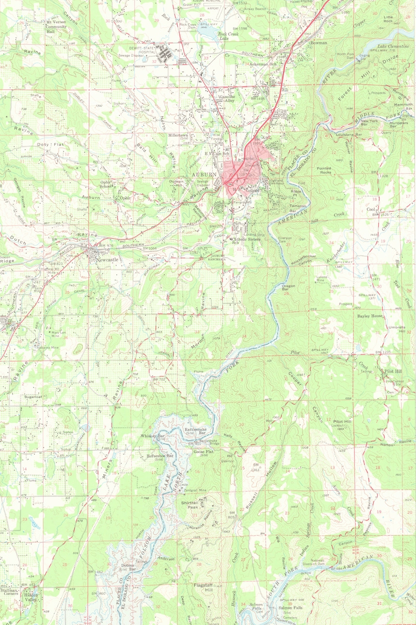 Figure 1c: Historical USGS Auburn Quadrangle (1953) The North Fork American River: North Fork Ditch, Oregon Bar and Kickerbocker Canyon post-dam construction. Notice the innundation by Folsom Lake near the bottom. 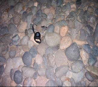 Figure 2a: Sailor Bar Armor  Figure 2b: Historical USGS Folsom Quadrangle (1941) Shows the confluence of the North, Middle and South Forks with the mainateam American River.  Figure 2c: Current USGS Sacramento Topographic Map Shows the development thus far of the region. | ||||||||||||||||
|
Analysis Particle size data was not available for the North Fork American, but bar deposition decreased after the mine was in operation. Nevertheless, there is currently some deposition of gravel and sand downstream. Mass wasting and erosion from steep hillslopes into the river supplies gravel and finer sediment which is transported downstream into Folsom Lake. Below the dam the bed and banks are armored by large cobbles, with sand and fine grained material creating bars at least one mile downstream. The incised river banks on the south bank show a gravel and sandy matrix from hydro-mining deposits, and this has become a major sediment source for the downstream reach. These deposits may also provide a representation of the type of material that one could expect to see being transported if the dam were not there. There is a high supply of sediment from the banks and erosion in the lower reach that somewhat makes up for the lack of sediment being delivered from upstream. However, many scientists believe that the river has incised back to its original elevation (Vyverberg, 1999; Williams, 2001; Horner, 2005).
The lack of particle size data limited the investigation to observations. Particle size data was available for parts of site 2, but only in reaches with proposed or active restoration/monitoring projects. Tim Horner at Sacramento State University has been working with the US Bureau of Reclamation in doing monitoring and restoration implementation to add gravel beds and create spawning habitat in the lower reaches below Nimbus Dam. In 1998, gravel (new and unsorted material) added to Sailor and Sacramento Bars to restore spawning beds was rapidly washed downstream from high magnitude, prolonged flows, but flows like that did not occur again for years (Horner, 2005). Therefore, it could be expected that the current status of the bars is similar to the non-restored state, which actually provides a better representation of the situation, but observed effects may have been dampened due to restoration efforts preceding this investigation. Sediment supply from upstream is limited due to the North Fork Dam and the mining operations, but there is much sediment moving downstream from erosion and mass wasting occurring after the mine site and just above Knickerbocker Canyon. Further collection of particle size data and examination of the mining effects upstream would broaden knowledge of the situation. Recently, gravel has been added to the bank just below the mine site, but much of it is just going to end up at the bottom of Folsom Dam in time. Besides the only restoration efforts the salmon will benefit from, are those implicated below the Folsom-Natoma System. | ||||||||||||||||
|
Conclusions Within the last one hundred years the American River sediment regime has changed drastically and the ecosystem has become incredibly altered. Damning the river negatively affected the spawning habitat for salmon and geomorphic instream deposition. The absence of sediment from flows leads to implications for sedimentation behind the dam system and for the quality of habitat downstream. The Folsom-Nimbus system is trapping larger sediments and passing the fines suspended in water downstream, while the bed becomes armored with large heavy cobbles that cannot be transported with regulated flows.
The American River has been through so much historically. Old topographic maps from the turn of the century really provided the best data because it was pre-hydromining /pre-dam construction. The problem with using older data and data that is not necessarily digitized is the fact that there is so much error introduced from the older technologies and lack of quality control. For example, so much less was known 100 years ago about the area that the Sacramento 1914 map only had the river and bank data. Surrounding areas had no data. Scaling issues between the aerial photos, historical and current topographic maps create uncertainty in comparisons, but changes in topography were still obvious. Actually few major scaling issues were encountered. Aerial photos obtained of site 1 were blurred at close range. Therefore, reliability was limited, but field observations provided a better understanding. Attempts were made to use ArcGIS to create a current map of the project sites. The data was collected to do so, but problems arised because the laptop computer being used was not up to the task. That made field and stereo image observations more vial. Nevertheless, the data collected provided sufficient evidence to accept the hypothesis that the Folsom-Natoma system has drastically changed the river and inhibits the maintenance of habitat and geomorphic features. The consequences of the dam system are what were expected and consistent with studies done on other regulated rivers. | ||||||||||||||||
|
References
California Geological Survey (2002) California Geomorphic Provinces. Note 36. Sacramento, CA. Friends of the River. (Sited visited Feb. 2007) Flaws in the Existing System Part II. http://www.friendsoftheriver.org. Goodwin, Peter, Falte, Michael and Betts, A. D. K. (2000) Managing for Unforeseen Consequences of Large Dam Operations. World Commission on Dams, Cape Town, South Africa. Hill, Mary (1985) California Landscape: Origin and Evolution. California Natural History Guides, 48. The University of California Press, Berkley, CA. Horner, Tim (2005) Physical and Geochemical Characteristics of American River Spawning Gravels. Draft Document of second year report, U. S. Bureau of Reclamation, Sacramento, CA. Knighton, David (1998) Fluvial Forms and Processes: A New Perspective.Oxford University Press, New York. Kondolf, G. Mathis (1997) PROFILE: Hungary Water: Effects of Dams and Gravel Mining on River Channels. Environmental Management, 21: 4: 533-551. Mount, Jeffrey F. (1995) California Rivers and Streams: The Conflict between Fluvial Processes and Land Use. University of California Press, Berkley, CA. Vyverberg, Kris (1999) DFG’s Revolutionary Pilot Program will offer Spawning Beds for Salmon and Steelhead, Department of Fish and Game News Release: Sacramento, Ca. Williams, John G. (2001) Chinook Salomon in the Lower American River, California’s Largest Urban Stream. Biology of Central Valley Salmonids. Fish Bulletin 179, Volume 2. | ||||||||||||||||