|
Yuba Highlands Risk Assessment through Spatial Analysis Ben Chambers American River College, Geography 350
Data Acquisition in GIS; Fall 2007
ben.chambers@comcast.net
 Abstract
This paper examines the relationship between historical military ranges and the current Yuba Highlands development project. Field data was collected using an EM61 detection device. Detected anomaly points were then retrieved and identified by trained UXO technicians. These data collection efforts were part of a larger project. The Former Camp Beale Site Investigation was commissioned by the Army Corp of Engineers and completed by Earth Tech, released in January 2007. This paper looks specifically at the result of the site investigation compared to the footprint of the Yuba Highlands development project. Several spatial and statistical anlyses tools are utilized to examine the data. These help to asses risk factors in the development area. Introduction The area to the south and east of Beale Air Force Base was known as Camp Beale during the US military operations prior to American engagement in World War II. This area, now know as the Former Camp Beale, was used extensively for military training using an assortment of live ordnance. Recently the Army Corps of Engineers called for a site investigation to asses areas of ongoing risk associated with these former military ranges which are now back in private ownership. Currently some of these lands have been selected for a large scale development project. This paper will use spatial analysis and GIS interpolation methods to examine assessed risks within the footprint of the proposed Yuba Highlands development project. Taking data collected for the Former Camp Beale Site Investigation we will conduct our own analysis of the risks associated with development of the Yuba Highlands Project. Specific spatial analysis outlined in this paper include determination of area not covered by the initial site investigation in the Yuba Highlands Development footprint, and risk assessment through spatial and statistical analysis. Background
Camp Beale was used extensively as an military training facility from
1942 until 1958. This facility included several heavy artillery and
small arms ranges. In 1948 Camp Beale was converted to Beale Air Force
Base where six air force bombing ranges were established averaging
1200 acres each. In 1959 the Air force bombing ranges at Beale were
decommissioned and portions of the base were declared excess by the
Air Force. Since these areas were decommissioned some 60,805 acres
have returned to private ownership, with a recommendation that these
lands only have "surface use". Source "Camp Beale Military Munitions Cleanup
Project Campbeale.org"
The Army Corps of Engineers recently commissioned a study to investigate the UXO hazards and perform a risk assessment of this Formerly Used Defense Site (FUDS) Site Investigation Earth Tech, Inc., 2007 Former Camp Beale Site Investigation Earth Tech Inc. 2007 to determine if these lands still have ordnance left over from historical training ranges, and if so what level of risk exists from these historic ranges. Recently there has been interest in developing lands that were formerly occupied by Camp Beale as residential subdivisions. The Yuba Highlands Project proposes to develop up to 5,000 homes on land that was formerly occupied by Camp Beale. In this paper we will examine the area proposed for development using spatial and statistical analysis. We will look specifically at data collected for the Former Camp Beale Site Investigation as it relates to the footprint of the Yuba Highlands development Project. For further review of the proposed Yuba Highlands development project please review Draft Environmental Impact Report and Land Use Plan Yuba Highlands Draft Environmental Impact Report or the development website at Yuba Highlands.biz Methods
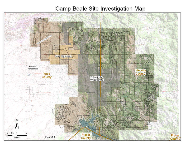
Data was collected for this project using EM61 geophysical detection equipment. The EM61 is a sophisticated cart generally operated by a team of two field technicians. After initialization and standardization the cart is towed along a series of North South lines transecting the project area. The EM61 is capable of detecting metallic anomalies beneath the earth's surface. When an anomaly is detected the location is marked through GPS synchronization. The data reflect a magnitude, or anomaly strength, based on the size and depth of the anomaly and a location generated by a highly accurate GPS system. The transects were approximately 600 feet apart and the EM61 width of reception is approx 1m wide. This coverage while adequate for initial investigation leaves large areas unexamined making it inadequate for final ground clearance without further sweeping and clearing activities. After transects were initially surveyed anomalies that were detected were further investigated by a team of UXO technicians. Upon further UXO investigation determinations could be made regarding the nature of the anomaly. Weather the anomaly had military origins or was from some non-military source. The data for this project has been previously published in the Former Camp Beale Site Investigation (Earth Tech, Inc. 2007), however specific analysis with regard to proposed development of the Yuba Highlands project site is unique to this document. In order to determine the coverage area of the EM61 transects first we will convert the track logs to raster from vector data. Since the EM61 cart foot print is roughly one meter wide, we convert to a raster grid with a one meter cell resolution. By calculating the EM61 track area and subtracting this area from the overall acreage of the Yuba Highlands development we can calculate the project area that has not been surveyed for ordnance. In order to determine the density of recovered anomalies we will calculate spatial statistics for average nearest neighbor, central feature, mean center, directional distribution, and standard distance. Further discussion of potential methodology in using GIS to map and model UXO specific to the larger Former Camp Beale Site Investigation can be found at GIS for Ordnance/Explosives Remediation, Formerly Used Defense Site, Camp Beale Results The Yuba Highlands project footprint covers 2892 (11,695,415m2) acres of lower elevation Oak woodland and grassland
areas (less than 1000ft.in elevation) The project footprint is between the active Beale Air Force Base
and the
Spenceville Wildlife Area which is managed by the California Department of Fish and Game
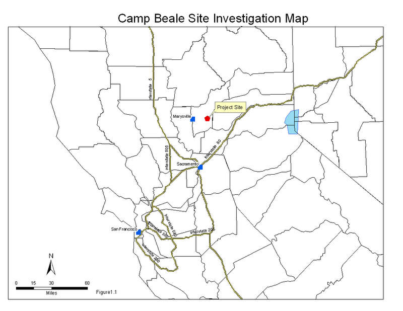
(see site location map fig. 1.1).
The area covered by field survey teams during the initial site investigation was approximately 57 miles (93,173m). This was surveyed using the EM 61 with transect lines running in North South Trends except where travel may have been impeded b terrain or vegetation. The EM61 track covers an area about 1meter in width. Using this information we can calculate the area within the Yuba Highlands project footprint covered by the EM 61 to be 23 Acres (93173 m2). In the area that was surveyed there were 599 anomalies detected. UXO teams investigated the anomalies and divided them into four categories. The breakdown of anomalies is shown in Figure 1.2.
Fig. 1.2 We can see from the table that a majority of anomalies detected and recovered in this area originated
from a military munitions source. Most of the munitions debris recovered in this exercise was deemed
non explosive. Only two items were considered to have explosive potential (MPPEH), however the
concentration of MD items strongly suggests that this area, now proposed for a major residential development,
was part of training range used by the former Camp Beale installation. Non-Munitions
items were located and identified but not removed due to their non-hazardous nature. No-find items
are perhaps the items of most concern represented in this table since they represent an unknown.
These items were not relocated, identified or removed from the area by UXO teams and therefore represent
a potential risk factor. If we conclude from this initial evidence that the potential for UXO exists in the Proposed Yuba Highlands project area then our risk assessment must seek further investigations to cover the remainder of the project area. These initial EM61 transects and UXO investigation teams have covered a small fraction of the area that is proposed for development. In fact only about 23 acres of the 2892 proposed for development was covered using these investigation techniques. Expressed as a percentage this is less than one percent of the project area. Clearly this leaves a large portion of the proposed development unsurveyed for UXO. Until the remaining area of this project site has been surveyed and cleared of all UXO it retains a level of risk, the exact level of risk cannot be determined without further evaluation. Using the existing data we can perform several functions of spatial and statistical analysis. These statistical analysis can give some insight to the potential distribution patterns over the project site, however without further site surveys using either the EM 61 or a grid type mag and flag operation, we cannot determine the absolute site risk with any certainty. Former Camp Beale Project Site Investigation Figure 1.3
Yuba Highlands Proposed Development Site Figure 1.4
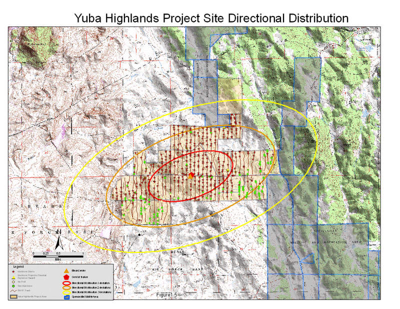
Using spatial statistical analysis tool available with ArcGIS software we can determine that the mean center
and the central feature are located very close together almost directly in the center of the Yuba Highlands
Project area. By inputting the anomaly locations we can also run spatial statistical analyses for
directional distribution and the standard distance from the mean center. If we run these analyses for
directional distribution with standard deviation values of 1, 2, and 3 we can see the results in Figure 1.5.
Figure 1.5
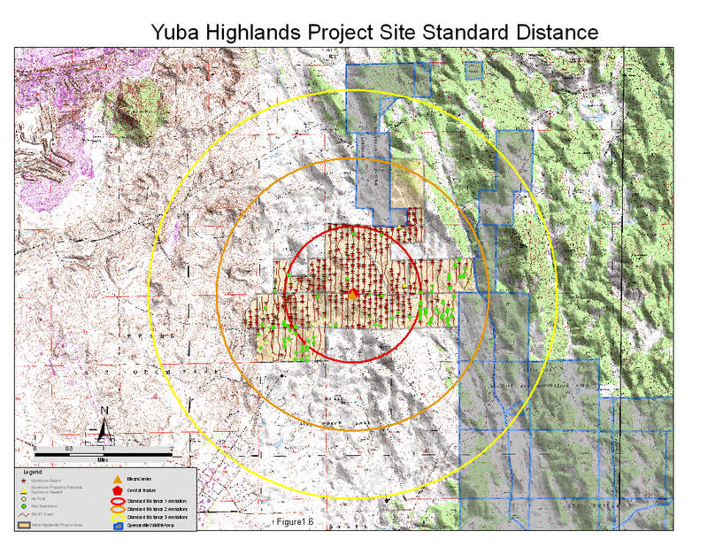
Running a similar function for standard distance with standard deviation values ranging from 1 to 3
we find the results displayed in figure 1.6.
Keep in mind that these were generated using only the anomalies within the Yuba Highland project area
There are additional anomalies that were detected outside of the project area, however this article examines only those
anomalies within the Yuba Highlands project area.
Conclusion
In conclusion we can see that there are significant risks related to UXO associated with developing the Yuba Highlands project site. The results of the initial EM 61 transect surveys have been verified by a secondary team of UXO technicians. The UXO team relocated and identified anomalies detected in the project area by the EM 61 survey. UXO items that were located and identified were removed from the project area. Most of the UXO related items were identified as munitions debris (MD, shrapnel), however some items were identified as having a potential explosive hazard. Non munitions items were relocated and left in the field by the UXO team since they pose no significant hazard. Items that were not relocated by the UXO team may seem to pose no further hazard, however these items may pose the greatest potential hazard since they were not located, identified or removed from the field. These no find items remain at large in the field and may or may not be related to UXO. The risks remain in the project area that remains unsurveyed for UXO, some 2869 acres of 2892 acres making up the total project site remain unsurveyed. This represents 99% of the project area is unsurveyed. The results of the surveyed area clearly show that the Yuba Highlands Project area was used as an active historic range for bombing and artillery targets Camp Beale Site Inspection Analysis and Conclusions and that the potential for UXO still exists in this area. The Yuba Highlands Draft EIR states "If potential unexploded ordnance is found to exist, its removal shall be accomplished in cooperation with the Corp of Engineers. Prior to the sale of any homes within a surveyed area, clearances from the Corp of Engineers and the State Department of Toxic Substance Control shall be obtained." Yuba Highlands Draft EIR This would seem to indicate further survey and clearance of the area is necessary before any development commences, However the project has already received initial approval from the Yuba County Board Of Supervisors |