|
Title Author Kelly Knapp 
I love my handheld GPS receiver. I love to plan out future trips in my Garmin Mapsource software or my National Geographic California State TOPO software. I love to create tracks of where I’ve been backpacking, cycling, geocaching or just traveling through a new city. It is during these events that I often take pictures to record my visual experiences as well. I have always wanted a way to easily tie the two together in a quick and automated way. GPS-Photo Link: Standard Edition from GeoSpatial Experts seems like the software program that can do that. Before spending the $229 asking price for it, I will test its accuracy and ease of use by riding my bike around the Greenhaven/Pocket greenbelts with my GPS and take some photographs of the area. GPS-Photo Link: Standard Edition is a software program that links digital pictures with the latitude and longitude of where the photo was taken by matching the timestamp information on the GPS track with the timestamp on the photos. Usable with any camera and mapping GPS, the standard version is offered from GeoSpatial Experts for $229. It can create an ESRI shape file that can be imported into a GIS where hotlinks are used so that a thumbnail of your photo pops up when the mouse hovers over the shape. The latest version, v.4, offers a Google Earth output as well as the traditional web page viewer for your georeferenced photos. Photos are labeled with user defined information for easy reference. The GPS-Photo Link software claims that it can save time in the field by not having to record coordinates in a notepad and by the ability to process hundreds of photos in minutes back in the office. This being stated, I assumed that I would be able to acquire my photos and GPS track with little or no note taking and be able to interpret them when I returned home. I started my GPS track on the levee of the Sacramento River just north of Riverside Blvd. I would precede southward mapping as many of the rideable trails or sidewalks in the greenbelts and canals as possible taking photos along the way. I would make a loop back and end my data acquisition at my apartment complex. I also marked waypoints when I took some of the pictures to compare the coordinates with the results from GPS-Photo Link. After the ride, I downloaded the data from the GPS to the computer and used the GPS-Photo Link to link the photographs to the GPS track. Equipment Used in Field:
In Office:
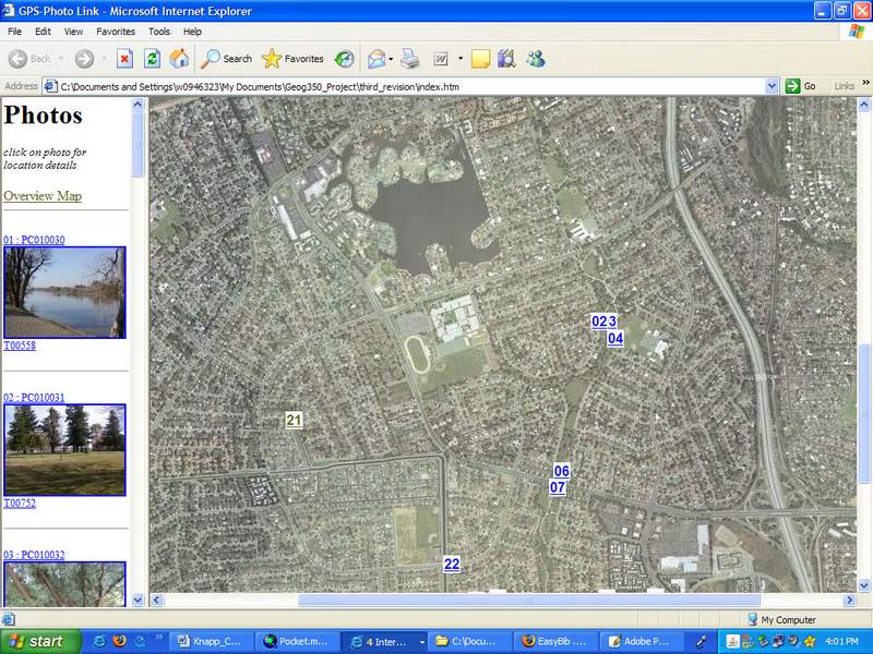 Figure 1: Web Output
2. Google Earth output – if familiar with Google Earth it is an interactive way to view our photos, tracks and waypoints. Save them to “My Places” for later reference. 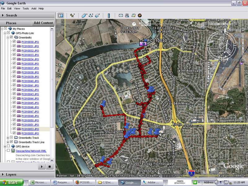 Figure 2: Google Earth Output 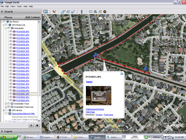 Figure 3: Hotlinked Photos
3. Text file (CSV) output – generated a nice tabular data sheet that references the photos, timestamp, coordinates, basically any of the comments that you could watermark on the images could be exported to this table. 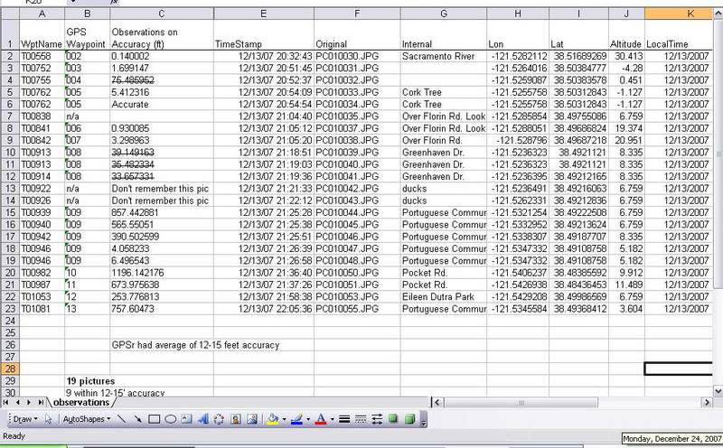 Figure 4: Tabular Data (right click over image & select "View Image" for a close up)
4. ESRI Shape File output – 2 shape files were created. One line file that was the GPSr track and a point file that had the photo locations. The point file has “hotlinking” capabilities so when the mouse hovers over the point, a thumbnail of the photo at that point pops up and can be selected to view a larger image. 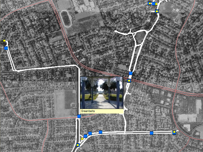 Figure 5: Hotlinked Photos 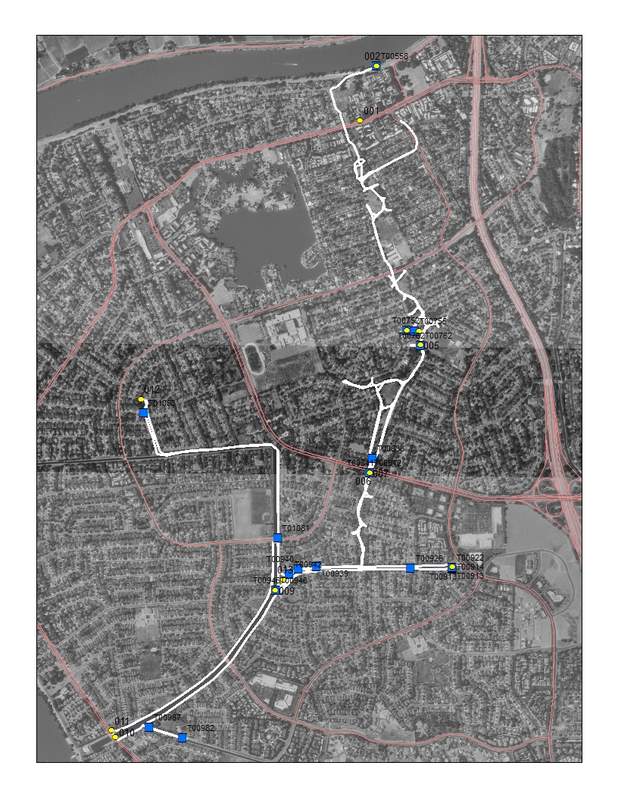 Figure 6: ESRI Shape File Output I also used DNR Garmin to download the 13 waypoints from my GPS that I inconsistently (oops) made at photo locations. They were marked to verify and check accuracies of where GPS-Photo Link would place photos.
Table 1: Measurement from Absolute Coordinates to Linked Coordinates
Immediately from visual inspection of the web output photos, I noticed inaccurate placement of a few of the links GPS-Photo Link made with the GPS track. The ArcMap file with the combined shape files and GPS waypoints confirmed this also. 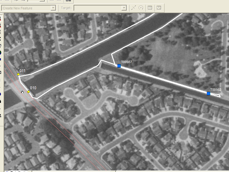 Figure 7: Hotlinked Photos In the image above, 010 and 011 are waypoints I marked at 2 separate photo locations. Points T00982 and T00987 respectively are the GPS-Photo Link images and locations. I used the “Measure” tool in ArcMap to measure from the waypoint taken at the photo location to where GPS-Photo Link had placed its link and inserted them in the table that was output in the text file (CSV) output.
It is interesting to note that the inaccurate links started approximately 50 minutes into the ride or 50 minutes after I synced the photos to the GPS track within GPS-Photo Link. To help increase the number of accurately linked photos, my method of collection should have been more documented. Since the GPS-Photo Link was supposed to save time on field notes, I didn’t bring any notes with me in the field. My attention to detail fell apart. I should have had a procedure outlined beforehand that would be followed each and every time a picture was taken for more consistency. Such as:
My research would have also been served better if I had planned out a map with locations that I wanted to take the pictures from, so I could reference that map at a later date. I had a few photos that I could not tell where they were taken them. Also more photos and matching waypoints recorded on the GPS should’ve been taken. This may shed some light on whether or not accuracy decreased just due to increase of time from the original time sync of GPS and photo timestamp. I collected data two other previous times where I took photos from an airplane window and recorded the track of the plane on my GPS. The first time I used GPS-Photo Link I was not connected to the internet. Therefore my overview and background photos were not generated. What also happened was I had saved my Active Track Log and so it used the same timestamp for all images. I didn’t notice that detail, partially due to my inexperience with the program and also because I didn’t have any overview photos to look at. The second flight of data I collected was corrupted because I saved my Active Track and was then unable to use it for my track in DNR Garmin. Two wasted trips that could have been used if I had researched the DNR Garmin extension more thoroughly before utilizing it. Therefore my third and final data collection trip was this bike trip. The GPS-Photo Link software was supposed to save me time. The software program is quite easy to use in a Wizard format that takes you through the necessary steps. Although due to the photos that were incorrectly linked to the track, I spent more time looking at those images and trying to figure out where they were were supposed to be located. Future research should be done before spending $229 on the GPS Photo Link Software. Data collection should be done again with the above recommendations and follow up analysis on the new data. Professional users that input in hundreds of images a day and perhaps use the GPS enabled Ricoh cameras and high end Trimble GPS units definitely save time with the GPS-Photo Link software and hopefully have better accuracy with the sophisticated GPS units. For the recreational user with only a limited amount of photos that need be georeferenced, I would probably not recommend the GPS-Photo Link software, especially with its cost. There are websites such as Ever Trail.com that allow geo tagged photos to be posted with a GPS route. Some websites have you manually enter in the latitude and longitude coordinates for each image. I’m sure with the advancement of technology, there will be more intuitive and easier ways to accomplish this task in the very near future. References Links
|