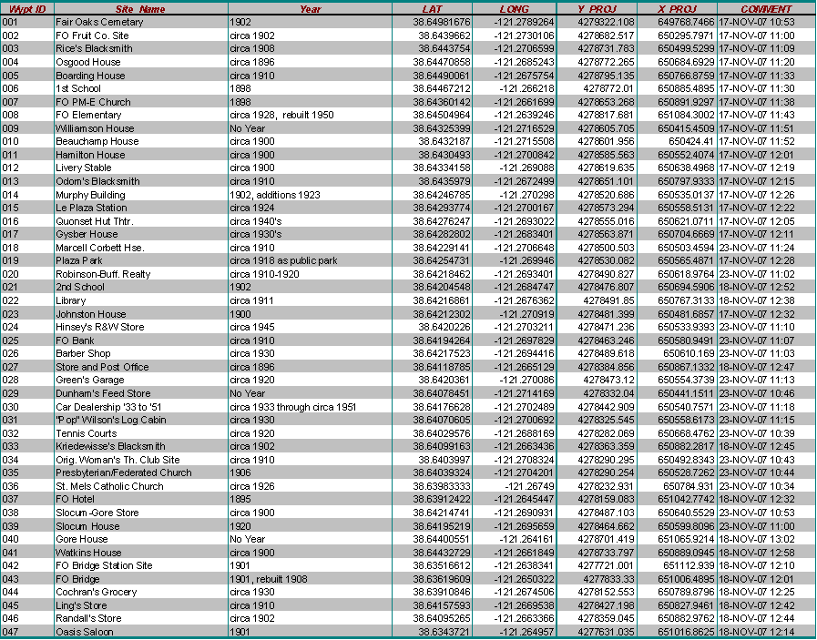
|
Title
A Historical Walking Tour Through Fair Oaks, California
Author
Stacey McClure
American River College, Geography 350: Data Acquisition in GIS; Fall 2007
Contact Information:
mcclursr@imail.losrios.edu
Abstract
Through my husband’s teaching career, I have noticed that
Fair Oaks, California is a unique California community. This led to my
interest in the history of Fair Oaks, from which I discovered a self guided
walking tour created by the Fair Oaks Historical Society. The Fair Oaks I
see today really began in 1895 as an agricultural venture in citrus, olives
and nuts. A small town village grew out of this venture. This was not
accomplished as easily as anticipated despite the ideal geography of the
community. However, its footprint remains today. Using a GPS, this tour is a
great exercise in collecting GIS data. Waypoints were downloaded to ArcMap
and Google Earth using DNR Garmin. Despite some inaccuracies in a few of the
waypoints collected, I am pleased with the results of this project. It has
resulted in my considering further participation in the Fair Oaks Historical
Society.
Introduction
My husband is a 3rd year school teacher who currently
teaches 2nd grade at an elementary school in Fair Oaks, California. This
year is his second year at the Fair Oaks school, Earl Legette Elementary.
His school has demonstrated to us that families in Fair Oaks have an amazing
sense of community, which we thought was hard to find in the greater
Sacramento area these days. The positive experience we've had interacting
with community members influenced our decision to move back to Fair Oaks
from Antelope, California this last June. We previously lived in Fair Oaks
from 2002 to 2005. We were familiar with the Fair Oaks area, but were not
directly immersed in the community. Fair Oaks is a unique area of greater
Sacramento, on many levels from its diversity to its main street center, and
I am interested in learning about the history here to see if it plays a role
in the current success of the community today.
In considering topics for my student GIS project, I browsed the web for
information about areas close to Sacramento that fall within topics I'm
interested in. I am pleased to have found a web site for the Fair Oaks
Historical Society, which illustrates how special Fair Oaks residents find
their community, and how special Fair Oaks is. The Fair Oaks Historical
Society has compiled a great deal of data on their web site, such as the
locations of historical sites, businesses, and homes and has even created a
self guided walking tour. For my project, I studied the history of Fair Oaks
and followed the walking tour to document its sites using a GPS and a
digital camera. Having very little experience with GIS and collecting data
for it, I explored the methods discussed in class to illustrate historical
locations in Fair Oaks using GIS.
Background
Fair Oaks was a part of the Mexican Land Grant in 1844
called Rancho San Juan, and Native Americans, the Maidus, lived here for as
far back as 10,000 years (Abbott, 2005). However, the sources I referred to
for background information on the history of Fair Oaks, focused on Fair Oaks
as we know it today. This is the community I can still see remnants of that
I am most interested in.
In the mid to late 1890’s, lots in Fair Oaks were advertised on the East
Coast as a Sunset Colony, or an agricultural venture where the purchaser
could come to a beautiful place with a moderate climate, produce citrus for
profit easily, and retire. Excursions were made by rail to Folsom beginning
in 1895. The first colonists must have been very impressed when they came
through Orangevale, which was successfully producing citrus, to the American
River bluffs overlooking the largest vineyard in the U.S., the Natomas
Company (Abbott, 2005). It was November and compared to the East Coast, it
was quite mild. Mostly hilly and consisting of Oak Forest, it was beautiful
but not as easy as advertised.
The colonists started from scratch, homes had to be built, equipment
purchased and brought in, the citrus, olive, and nut trees had to be brought
in, the forest cleared, and even water had to be shipped to the homes,
farms, and orchards. The original company selling the lots, the
Howard-Wilson Publishing Company pulled out in 1898 when land sales were
poor. The Fair Oaks Development Company, out of Orangevale, gave it a go
about a year later. They were successful in getting Sacramento County to
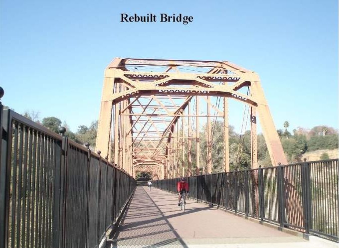
build a bridge across the American River and a rail line to the bridge. They
also built a water system. Despite their efforts, sales were down and they
also moved on in 1902 (Abbott, 2005).
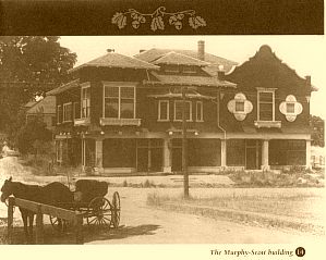
Some of the residents of Fair Oaks were entrepreneurial and hard working.
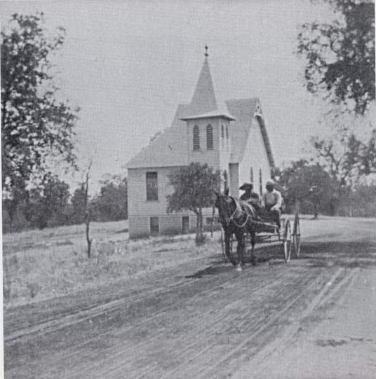
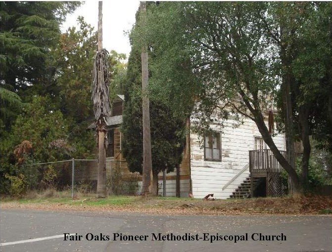
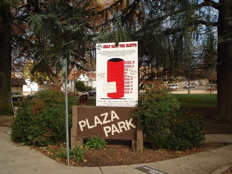
They were able to continue on. A small town was built with a school, a
church, a citrus coop, merchants, a bank, etc…The village in Fair Oaks is
centrally oriented with a park. A rock crushing plant came from the dredging
of the American River for gold. Despite the effect of the Great Depression
and a major citrus freeze in 1932, the residents recovered and over the
years saw an improvement in transportation and began to commute outside of
the community to make a living, such as at the Mather and McClellan Air
Force Bases and the aerospace industry (Abbott, 2005).
I watched a Fair Oaks Historical Society video titled, “Fair Oaks, the Way
it was.” In the video, elderly residents who grew up in Fair Oaks talked
about Fair Oaks success and sense of community. Bill McPhail stated that the
sense of community comes from having a village center. He touched on
something that led me to learn more about Fair Oaks’ past, you can actually
see and relate to the history. Other residents all indicated that their
special memories of Fair Oaks came from the open space interspersed here,
still seen today, the river, small town feel, the climate, and it’s a great
place to retire. Despite the hard work and setbacks, the advertisements for
the Sunset Colony were not too far off the mark.
Methods
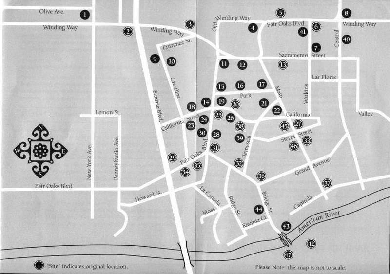
Over the course of three days, November 17th, 18th and the
23rd, I either drove or walked to locations on the Fair Oaks walking tour
map. At each location, I used the Garmin GPS borrowed in class to mark a
waypoint identified by the number on the tour. I began at the first site
listed on the tour, the Fair Oaks Cemetery, which was also the furthest
away. The tour ended in the village as I found it easier to work my way from
the outlying locations inwards.

It was my intention to use GPS Photo Link, so I used my digital camera to
take a photo at each place. I used a notebook to list each waypoint by ID
number and to remark on anything special such as why a photo was not taken
or whether the site was located or was unclear in position, and why.
Prior to starting the walking tour, beginning in the month of October, I
walked from my home to the village and back for exercise a few times a week.
This helped me familiarize myself with local streets and locations on the
tour map. During the three days of my field work, I also studied several
photos on the Fair Oaks Historical Society web site at http://www.fairoakshistory.org/
that were applicable to the locations on the tour, in order to help me
identify them while in the field. Many of these photos were saved to file as
JPEGS for use in my presentation and web site for this project. I also used
the following books for historical images:
• “Images of America, Fair Oaks” by Lee M. A. Simpson and Paul J. P. Sandal
• “Fair Oaks, the Early Years” by the Fair Oaks Historical Society
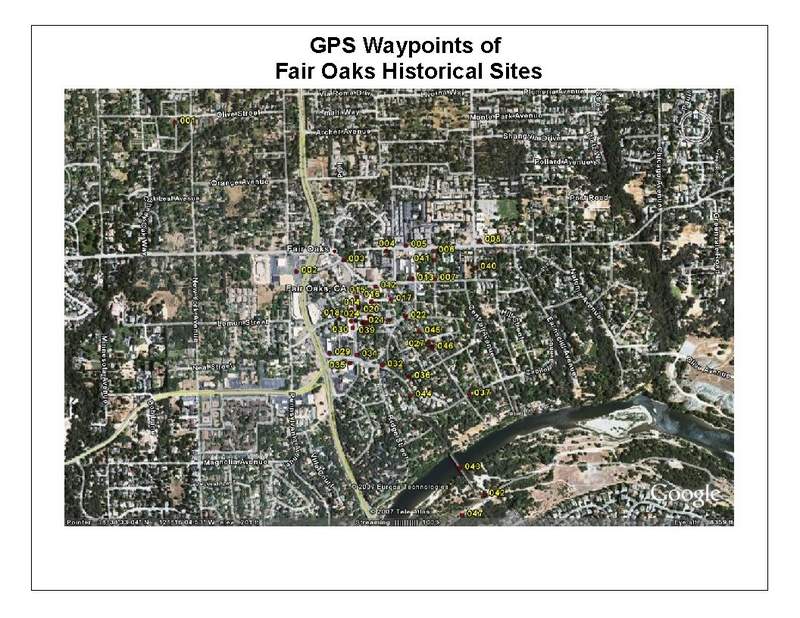
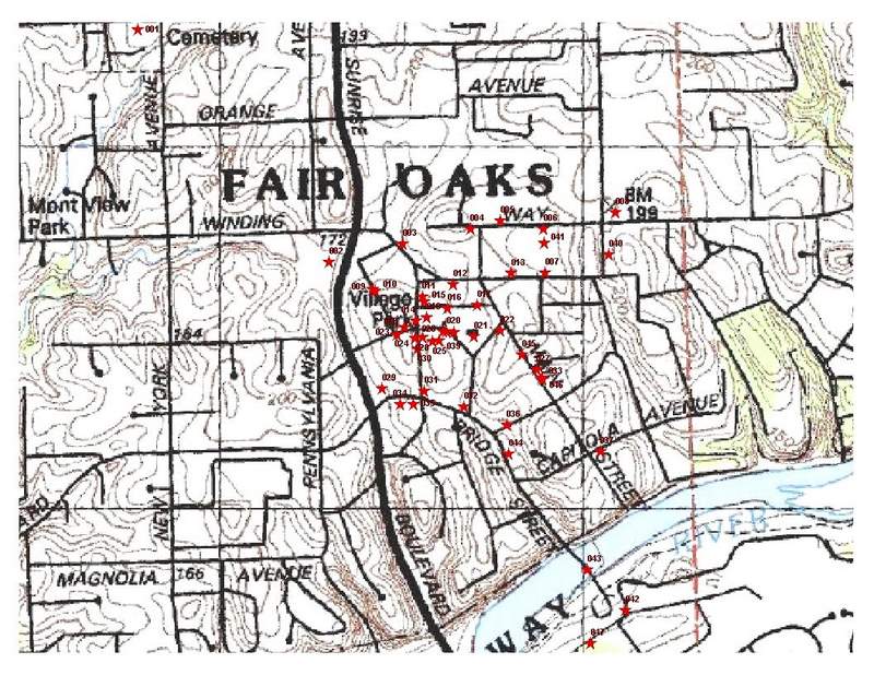
I used the DNR Garmin software to download my waypoints directly to ArcMap
9.2. In ArcMap, I added fields to the attribute table of my waypoint shape
file to name each location and to date them. A text file was made from the
attribute table and placed into an Excel spreadsheet to further format the
applicable data. I used the TerraServer USA web site at http://terraserver.microsoft.com/
to download aerial and USGS topographic images as backgrounds for my
waypoints. I also took advantage of the Export to KML tool made available in
class to export my waypoints to Google Earth. In Google Earth, I played
around with the symbols and colors of the markers to label the waypoints and
validate the accuracy of the GPS compared to the walking tour map. I saved
my final Google Earth results as JPEGS. I used many of my images in ArcMap
to add titles, and resave as JPEGS.
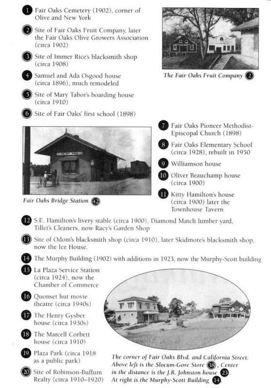
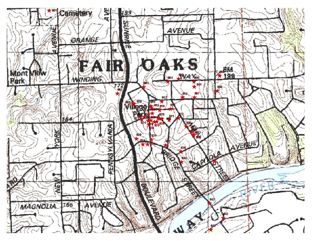
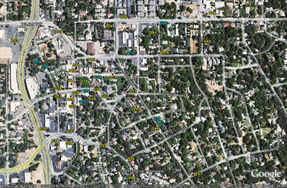
Results
to enlarge
to enlarge
to enlarge
I was successfully able to accomplish my goal for this project. The
following maps are my Google Earth and ArcMap results showing all of the
waypoints I marked. Please see the following table for a reference of the
data I collected, which was made from my attribute table. I have also
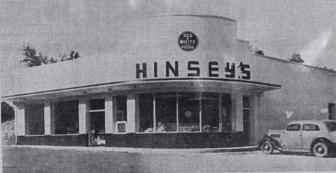
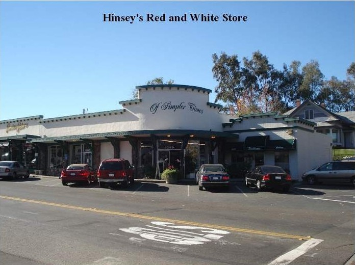
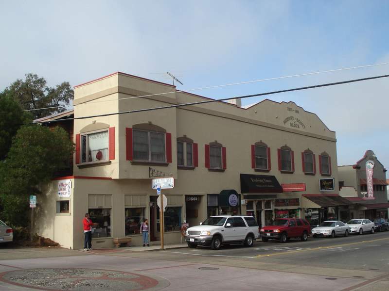
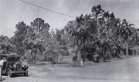
provided a selection of photos I took along the self-guided tour, in
addition to the historical photos of the same location gathered from the
Historical Society’s web site.
Analysis
I am happy that I was able to accomplish my overall goal in
this project. I did, however, face some difficulties in completing this
project, and I have some constructive criticism of the walking tour the Fair
Oaks Historical Society provides.
I was hoping to use GPS Photo Link in this project, for practice. On day 1,
I planned to take a photo my GPS at waypoint #1 prior to marking my
waypoints and taking photos. I failed to do so. I discovered my oversight at
waypoint #8 and took a photo of my GPS at that time. The current software
demo only allows for 10 photos. I visited 47 locations and have 38 photos.
When I was unable to successfully use GPS Photo Link with my first batch of
waypoints on day 1, I did a test run while traveling from Fair Oaks to
midtown Sacramento at a later time. In that test, I discovered that my
camera’s date was one month ahead. Although I could specify the difference
in the program, I should have also synchronized my camera in the beginning.
The walking tour does not provide addresses for structures that still stand
nor does it provide information on the current status of the site you are
directed to. For example, waypoints #9 and #10, the Williamson and Oliver
Beauchamp Houses respectively, are close to similar houses at the end of
Crestline near Entrance Street. I was unable to determine what I was looking
at on either side of the street. Therefore, I estimated my position from the
walking tour map, and took photos of the four houses total on that end of
the street. Other locations were simply sites. Waypoint #5, Mary Tabor’s
boarding house, appears to have been somewhere where two small apartment
complexes now sit. It would be useful to have it noted on the tour that the
structure no longer exists.
In Figure 1, I have highlighted waypoints (in blue) which were not accurate
in their position. For example, waypoints #13, #6, and #20 are shown across
the street from their actual location. There are 9 errors out of 47
locations, or a 19.15% error rate.
Figure 1
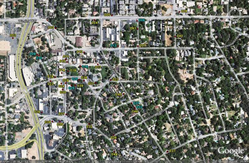
to enlarge
Conclusions
I feel like I know Fair Oaks much better and I will never
walk through, or drive through, the Fair Oaks Village and surrounding area
again without thinking about the history here. I even found some neat little
businesses that I would like to look at further. My tour and “The Fair Oaks,
the Way it was” video really answered for me the sense of community my
husband and I are lucky to have experienced at his school. Fair Oaks was and
is a nice place to settle and its geography remains appealing to the
residents. In my mind, the Fair Oaks we know today is a relatively unchanged
area despite the major thoroughfares surrounding it, such as Madison Avenue
and Sunrise Avenue.
The Fair Oaks Historical Society encourages membership and participation in
its efforts. In order to create an accurate map as possible of our
community’s historical locations, I can work with them to learn more about
the locations listed on their walking tour. By participating in their forum,
I could also eventually share the benefits of using GIS and GPS with them
for creating future references for public use.
References
• Abbott, Steve, 2005. The History of Fair Oaks. Fair Oaks Historical
Society. 1 December 2007.
http://www.fairoakshistory.org/history/fohist.htm
• Fair Oaks Historical Society, 1991. Fair Oaks, the Way it was. Deja View
Productions.
• Fair Oaks Historical Society, 1995. Fair Oaks, the Early Years. 14, 23,
37, and 39.
• Fair Oaks Historical Society. October to present 2007.
http://www.fairoakshistory.org/
• Simpson, Lee M. A. and Paul J. P. Sandul, 2005. Images of America, Fair
Oaks. Arcadia Publishing. 9-18.
• TerraServer USA. 22 November 2007.
http://terraserver.microsoft.com/image.aspx?t=4&s=14&x=203&y=1337&z=10&w=1&qs=%7cfair+oaks%7cca%7c |