| Title "The Perfect Firestorm" Fire Analysis within California's Southern Lake Tahoe Basin | |
|
Author Ryan Willis, Forester's Co-Op American River College, Geography 350: Data Acquisition in GIS; Spring 2008 Contact Information (415 Colfax Ave., Grass Valley, CA 95945, rhwillis2@hotmail.com) | |
|
Abstract This analysis used spatial data together with historic fire data, to model multiple fires within the Southern Lake Tahoe Basin Management Unit. This scenario used “potential ignition sources” to illustrate fire behavior patterns, assets at risk, and environmental damage on four separate fires. Theoretically, under extreme fire weather conditions all four fires could occur during the same period and as concluded would cause economic and environmental catastrophe. As seen in the 2007 Angora fire (campfire), human ignition sources are increasing as the public continually encroaches into the Basin. Land managers, Firefighters, and Local Agencies all must take the only pre-emptive management practice, in reducing the highly stocked stands of trees and fuels by logging and reducing stand density levels back to historic norms. If this does not occur, it is not a matter of IF but WHEN a scenario similar to this “Perfect Firestorm” simulation will occur. | |
|
Introduction As seen in the past years, catastrophic wildfire events in California are seemingly becoming more common and destructive. In 2007 Southern California witnessed one of the worst fire seasons in recorded history. Heavy fuel loads carried by Santa Anna wind events, confirmed that under extreme weather conditions firefighters are left helpless in protecting California’s valuable resources. The State’s rich fire history is not limited to the chaparral vegetation types of Southern California. Every year the Central Sierra Nevada Mixed Conifer Forests are more and more at risk to catastrophic wildfire events. Last year between June and July the Lake Tahoe Basin witnessed first hand what extreme wind conditions coupled with past misguided forestry and fuels management practices can result in. The Angora Fire destroyed 309 structures, and now ranks as the fourteenth most damaging structural fire in California’s history. In size comparison the fire was relatively small, only burning 3,100 acres compared to the 2003 Southern California Cedar Fire which burned 273,246 acres. Unfortunately, unless policy makers and land managers change pre-emptive vegetation management practices the Angora fire will be considered small in comparison to what future wildfires hold within the Lake Tahoe Basin. Using GIS datasets including historical fires shape files, digital elevation models (slope, elevation, aspect), weather patterns, and vegetation types programs such as Farsite and FlamMap can be utilized to model fire behavior within a GIS framework. With fuel loads and forest density levels at historical highs homes, property, and environmental resources are in great jeopardy from being destroyed. Like all models, fire modeling can be highly variable and difficult to calibrate with real world circumstances. This paper attempts to model fire within California’s Lake Tahoe Southern Basin using GIS datasets and spatial analysis. The results of the paper are hoping to yield figures such as number of parcels at risk, size of potential fire events, and potential for environmental loss. In the motivation of “Keeping Lake Tahoe Blue” I’m hoping this paper will shock public perception into “Lets Keep Lake Tahoe From Turning Black”. | |
|
Background During preliminary scoping, historic fire history within the Lake Tahoe Basin Management Unit (LTBMU) is surprisingly limited. According to the Fire Resource and Assessment Program (FRAP) administered by California Department of Forestry, prior to the Angora fire, the Gondola fire (673 acres) and the Showers fire (294 acres) were the largest recorded wildland fires in the Basin. Both of these fires occurred in 2002. This is in part to historic lower intensity fires that burned at occurrence levels approximately 5 – 20 years. Within the last century fire suppression efforts decrease in fuel reduction projects have increased tree densities as well as ladder and surface fuels. Unfortunately, this can be witnessed in last year’s Angora fire that now stands as the largest and most destructive fire in the Basin’s history. The Angora fire was an awakening to many people, including agencies such as the Forest Service whose management of the surrounding forest has been questioned by local foresters and community members for years. Following the fire an intensive investigation and analysis took place. Two recent and relative publications were used for the preliminary scoping and calibration for this analysis. The Forest Service quickly released the document entitled Assessment of Fuel Treatment Effects on Fire Behavior, Suppression Effectiveness, and Structure Ignition on the Angora Fire (Murphy, Rich, Sexton, August 2007) . This document outlined biophysical attributes such as topography, vegetation, and weather which were used for modeling purposes. The second publication entitled Greenhouse Gas Emissions from Four California Wildfires: Opportunities to prevent and reverse environmental and climate impacts (Bonnicksen, March 2008) summarized environmental consequences and forest management practices relevant to today’s “ever changing” anthropogenic attributes. The Forest Service Angora Report summarized the effects of fuel reduciton on forest service land in relation to fire behavior such as rate of spread, flame length, and heat intensity. A fundamental wildland fire behavior principle states that fire intensity and rate-of-spread increase as slope increases. For this reason, fuel treatments need to be more intensive (more surface fuels removed and wider crown spacing) on slopes to achieve the same effect as on flat ground. "On the ground" experience has shown this has not been the case on Forest Service projects with higher limitation on tree reduction on steeper slopes. The picture below, does depict a fuel treatment that dropped the fire from the crown to the ground but unfortuantely the fuel break was not large enough to make a significant difference. According to the Bonnicksen document using pre-fire data for the forest, combustion emissions could have been lowered from 46.2 tons per acre to 12 tons per acre if the density of trees had been reduced from 273 per acre to the more natural density of 60 per acre. The report goes on to mention a fire burning in the same forest after thinning would not have been catastrophic. It would have killed few large trees, covered less acreage, and left adjacent communities relatively unharmed. Bonnicksen illustrates by Salvaging burned timber within the Angora fire the opportunity (2 year window from July 2007) that still exists to fight global warming and protect the rest of the Tahoe Basin as well as other forests and communities in California and the West. The table below outlines carbon reduction savings on four of last years 2007 fires, note as of date the Angora fire has not been Salvage Logged. |
|
|
Methods For this analysis FlamMap was chosen as the fire modeling software to be utilized, spatially modeling fire in a GIS framework. For initial modeling efforts, a fire landscape file needs to be built made up of five separate raster layers with the exact same spatial extent and resolution. First using a 30 meter Digital Elevation Model (DEM), three raster files are created using ArcInfo Spatial Analyst. Percent Slope, Aspect, and Elevation are all created using the input DEM data source. Again matching the exact same spatial extent and resolution for all three layers. Next a fuel model layer is built using local vegetation types, Wildland Habitat Relation (WHR types), and/or field inventory. This is the most difficult layer to create, due to variability in vegetation types, finding geographically accurate data, and creating a raster layer with similar projection, extents, and resolution as the other layers. Lastly, using the fuel model layer a canopy cover layer is created based on vegetation types. This layer breaks vegetation canopy into four percentage categories 25, 50, 75, and 100. After all raster files are created, they are converted to an ascii file and inputted into FlamMap for creation of a fire landscape file. This landscape file is the data foundation that models fire behavior in specific geographic locations. After the landscape file is created weather, fuel moisture content, wind speed and direction are manually entered into FlamMap. This data was taken from actual Remote Area Weather Stations (RAWS) during the 2007 Angora Extreme fire weather event. Burn period is then calculated at for how long the fire is actively burning. The table below outlines these parameters. Next is to input ignitions point locations into FlamMap. Five ignition point shape files were created based on different potential ignition sources. First, the Angora fire ignition source was inputted and modeled to help calibrate the model to “real world” conditions of the Angora fire. Four different “potential” ignition sources were then used to model four separate fires within the Southern Lake Tahoe Basin. The first was the Gillmore Lake ignition source, located near the popular fishing and hiking location. This would be a human caused fire, possibly an illegal campfire. Next, was the Trout Creek ignition source located near the confluence of Trout Creek and an Unnamed tributary. Again a human caused fire, possibly by hikers or fisherman. Third, was the Lightning ignition source which used lightning strike data collected from the USFS Remote Sensing Lab to identify lighting locations that have occurred multiple times. This was the only natural ignition source that was modeled. The last fire is the HWY 89 fire, built to simulate a vehicular ignition source from the highway. | |
|
Results After the FlamMap “potential” fire models were complete the results of the four “simulated” fires were broken down into three quantitative categories; 1) Acres Burned 2) Assets at Risk 3) Environmental Damage. The amount of Acres burned was used as the foundation for quantitative analysis. The fire behavior perimeter is outputted as an ascii file and then converted in ArcInfo to raster format. The amount of acres burned within the simulation gives an idea of potential magnitude of the fire. The bar graph below illustrates the acres burned within the four simulated fires. 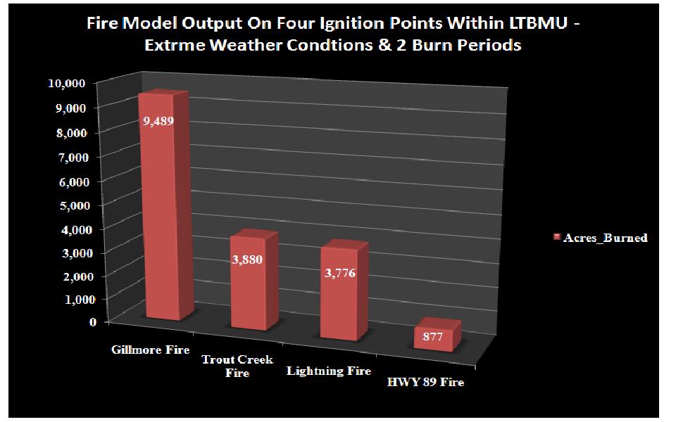 Assets at Risk are a difficult numbers to measure. For this analysis, El Dorado County Parcel Data was used to identify parcels with an improved value greater than $10,000. If the simulated fires burned into one of these pre-defined parcels, one asset at risk was tallied. This does assume that if the modeled fire burned through a parcel the structure, house, etc. was damaged or destroyed. The below line graph illustrates potential Assets at Risk among the four simulated fires. Environmental Damage can cover a wide range of variables. For this project, emissions of carbon dioxide during the fire event was chosen as one measuring tool. As mentioned in the background portion of this project the Bonnicksen March 2008 publication was of great help in applying “real” numbers associated with the Angora fire to the four simulated fires. The data is displayed below in tons of carbon emitted for each modeled fire. Furthermore to display the carbon numbers in more meaningful terms, the below graph equates each simulate fire to number of cars driving for one year.  | |
|
Figures and Maps The following six maps were created for the analysis; 1) 2007 Angora fire perimeter comparison to Simulated Angora Fire 2008 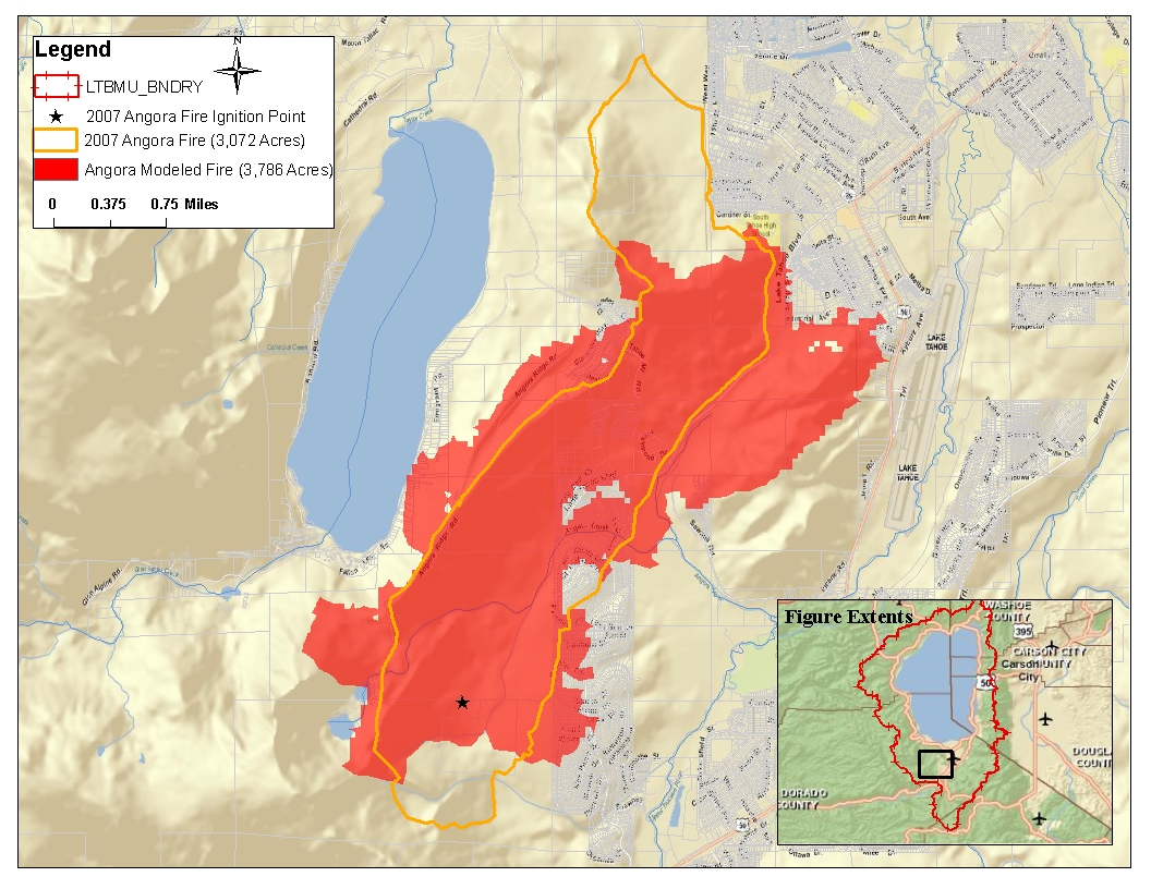 2) Simulated Gillmore Fire – Human Caused (Campfire, etc.) 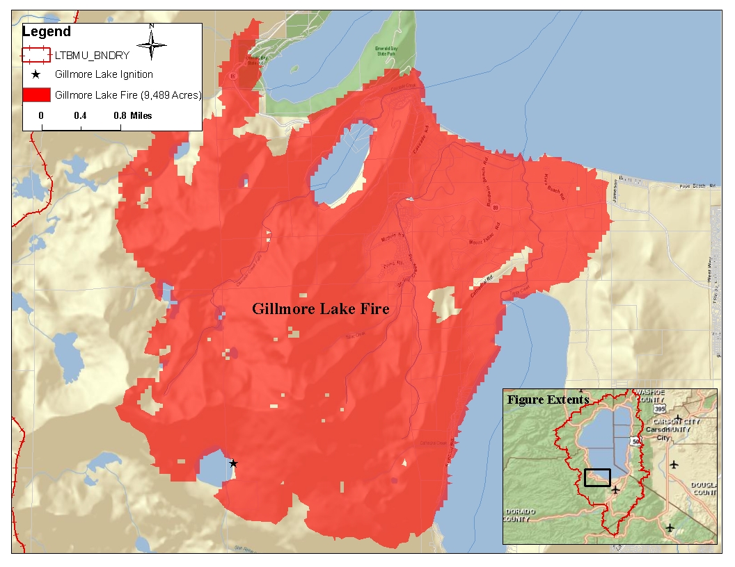 3) Simulated Trout Creek Fire – Human Caused (Fisherman, Hikers, Illegal Campfire) 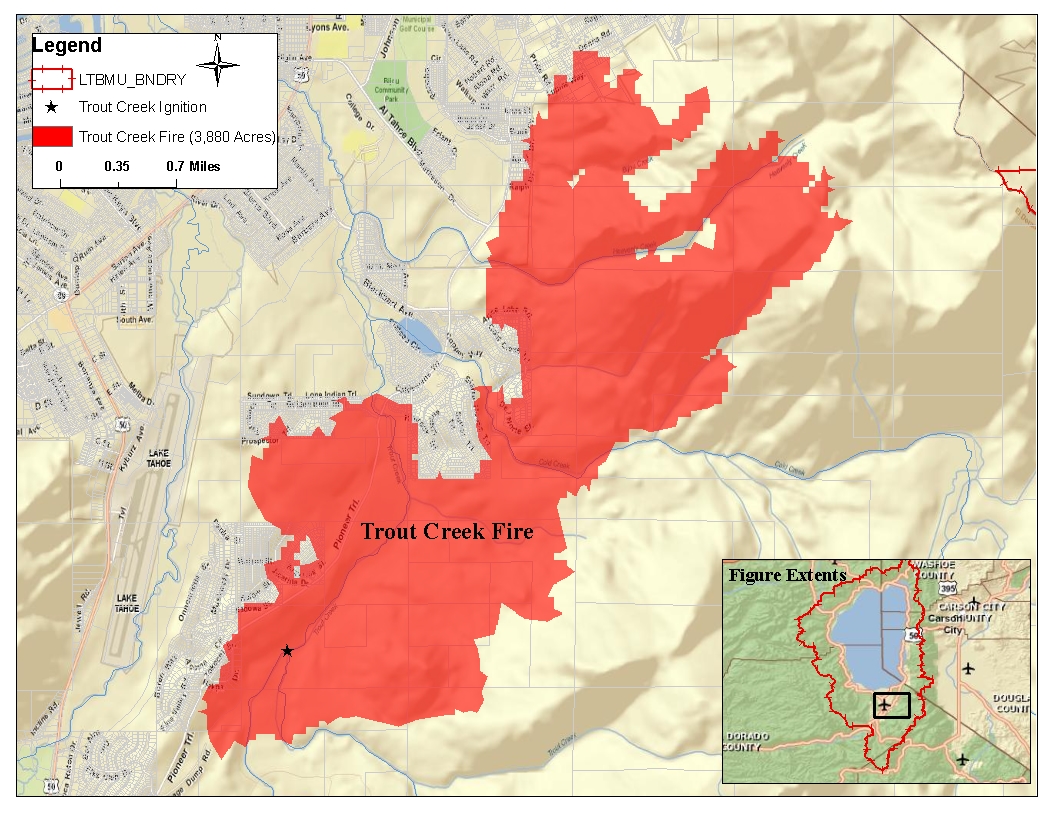 4) Simulated Lightning Fire –Natural Caused (Used Real Lightning Strike Data) 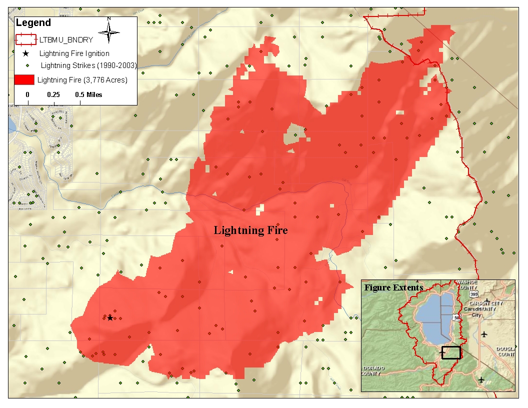 5) HWY 89 Fire – Vehicle Caused (Along HWY 89 corridor) 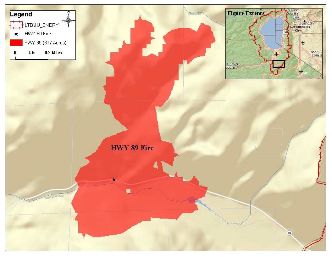 6) Overview Fire Storm Map 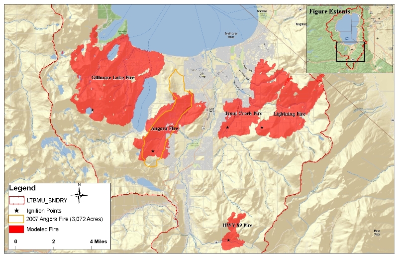 | |
|
Analysis I was impressed on how close the simulated Angora fire perimeter and acres burned compared to the 2007 Angora fire as seen in the graph below. This initial simulation gave me confidence in modeling the four fires used for this analysis. It was interesting to see how different the fire behaved on four separate geographic locations with the Southern Lake Tahoe Basin. Fuels, topography, and weather obviously played the largest role in the fire behavior within the simulations. Identifying potential ignition sources, predicting future fire perimeter areas, at the same time identifying possible assets at risk all are great successes of this project. The environmental damage the simulated fires could cause posed to be difficult. Initially water quality was going to be analyzed, but with no quantitative measuring tools I decided to analyze Air Quality instead. Using current publications I felt this turned out to be a great success of the project. | |
|
Conclusions As mentioned in the two referenced publications, fuel densities within the Lake Tahoe Basin Management Unit are at historic highs. Spatially modeling fire using software programs such as FlamMap allow land managers and local agencies to geographically identify strategically placed fuel breaks into the future. As witnessed in the 2007 Angora fire, extreme weather conditions coupled with very high fuel loads make it near impossible for firefighters to protect homes and property. With the ever increasing Wildland Urban Interface, human ignitions sources are only likely to increase. Taking a pre-emptive approach with fuel reduction efforts including selectively logging larger trees may be the only way to limit this type of catastrophic fire event. In only a two day period, this analysis of the “Perfect Firestorm” illustrates the devastating potential fire could have on homes, lives, and the environment. In the inspiration of protecting this “Jewel of the Sierras”, I hope land managers understand the future risk and this scenario never comes to life. | |
|
References Thomas M. Bonnicksen, Ph.D., 2008. Greenhouse Gas Emissions From Four California Wildfires: Opportunities to Prevent and Reverse Environmental and Climate Impacts FCEM Report No. 2 Murphy, Rich, Sexton, 2007. An Assessment of Fuel Treatment Effects on Fire Behavior, Suppression Effectiveness, and Structure Ignition on the Angora Fire Forester's Co-Op GIS Database, 2008 | |