|
|
|||||||||||||||||||||||||||||||||||||||||||||||
|
Authors
|
|||||||||||||||||||||||||||||||||||||||||||||||
|
Abstract
|
|||||||||||||||||||||||||||||||||||||||||||||||
|
Introduction
Today
LANDSAT is important both in its own right as a remote sensing system that
has contributed greatly to earth resources studies and also as introduction
to the study of more sophisticated satellites. The
LANDSAT system consists of spacecraft borne sensors that observe the earth
and transmit information by microwave signals to ground stations that receive
and then process data for dissemination in both image and digital format to
the user community. The
Method and Material will be IDRISI: The Kilimanjaro Edition consists of a
main interface program with menu and toolbar system and a collection of over
200 program modules that provide facilities for the input, display, and
analysis of geographic and remotely sensed data. In this project will analyse image of
vegetation by Thematic Mapper (TM) data in seven spectral bands. Band 6 scans
thermal (heat) infrared radiation. Also, analyse image of MSS (Multispectral
Scanner) in four bands. |
|||||||||||||||||||||||||||||||||||||||||||||||
|
Background
Remote sensing can be defined as any process
whereby information is gathered about an object, area or phenomenon without
being in contact with it. Remote
sensing has come to be associated more specifically with the gauging of
interactions between earth surface materials and electromagnetic energy. Why they named this
programme (IDRISI)? Because
the famous Arab Geographer Abu Abd
Allah Muhammad al-Idrisi or simply El Idrisi (Arabic: Latin: Dreses) (1100 – 1165 or 1166) was an Arab geographer, cartographer and traveller who lived in Sicily, at the court of King Roger II. Muhammed al-Idrisi was
born in the North African city of Ceuta then belonging to the Almoravid Empire (nowadays Ceuta, Spain) and died in Sicily, or maybe in Sabtah. The airport of the Moroccan city Al Hoceima is named after Al Idrisi. Al Idrisi was a descendent of
the Idrisid rulers of Morocco. IDRISI:
The Kilimanjaro Edition differs from most other GIS and image processing
software in that it supports real number images. Thus the descriptions that
follow describe these vegetation indices without rescaling suit more limited
data types. Also, the IDRISI saved
large amount of money to use LANDSAT programme and analyse it. |
|||||||||||||||||||||||||||||||||||||||||||||||
|
Methods
& Materials
Although
IDRISI is adept at the input and display of image and vector layers, analysis is primarily
oriented toward the use of image layers. In addition, IDRISI offers a
complete image processing system for remotely sensed image data. As a result, it is commonly described as a
raster system. IDRISI does offer
strong capabilities for the analysis of vector attribute data, as well as
rapid vector to raster. The system offers a powerful set of tools for
geographic analyses that require both types of map layers. Display
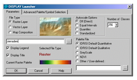
launcher is used to open a new display window. It begins the map composition process, and
is always the firs operation required to create and new map display. Display Launcher can be accessed from its
toolbar icon or by choosing it from the display menu. Doing so opens a dialog bow with options or
displays a raster layer, a vector layer, or an existing map composition.
When select a raster or a vector layer, IDRISI uses a set
of decision rules based on the values in the layer to appropriate palette or
symbol file. Must also specify if the layer should be displayed with a direct
relationship between numeric values and symbol codes, or should be
autoscaled. The case of map
composition it will only be required to specify its name, since all display
parameters are stored in the map file. The
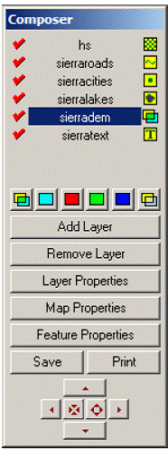
Composer dialog box appears on the screen Composer can be considered a
cartogphic assistant the allows on to 1- Add
or remove layers from the composition.
7. Save the current composition (as displayed) as a MAP file. |
|||||||||||||||||||||||||||||||||||||||||||||||
|
Results
& Analysis Thematic Mapper (TM) TM
which can be considered an upgraded MSS.
In these satellites, both the TM and an MSS are carried on an improved
platform that can maintain a high degree of stability in orientation as a
means of improving geometric qualities of the imagery. In addition, the
satellite is designed to permit access and service by the space shuttle. The TM is essentially an improved MSS its
design and operation are based upon the same principles as the MSS, but its
design is considerably more complex.
It provides finer spatial resolution, improved geometric fidelity,
greater radiometric detail, and more detailed spectral information in more
precisely defined spectral regions.
The objectives of the second generation of LANDSAT instruments are to
assess the performance of the TM, to provide continued availability of MSS
data, and to continue foreign data reception.
Like the earlier LANDSAT 4 and 5 are experimental programs intended to
lead to an operational system, which is as yet uncertain with respect to both
design and funding. TM
imagery is analogous to MSS imagery with respect to area coverage and
organization of data into several sets of multispectral digital values that
overlay to form an image. In comparison with MSS images, TM imagery has much
finer spatial and radiometric resolution, so that TM images show relatively
fine detail patterns of earth’s surface.
Despite
the historical relationship between the TM and the MSS, the two sensors are
distinct. The
TM sensor is an advanced, multispectral scanning, Earth resources instrument
designed to achieve higher image resolution, sharper spectral separation,
improved geometric fidelity, and greater radiometric accuracy and resolution
than the MSS sensor. The TM data are scanned simultaneously in seven spectral
bands. Band 6 scans thermal (heat) infrared radiation The TM records seven
spectral bands:
These
spectral bands have been carefully tailored to record radiation of interest
to specific scientific investigations, as suggested above. Spatial resolution is said to be about
30x30m about 0.09ha, or 0.22 acre, compared to the 76mx76m of the MSS. TM band 7 has coarser spatial resolution of
about 120x120m. The finer spatial
resolution provides a noticeable increase in spatial detail recorded by each
TM image. Each
scan of the TM mirror acquires 16 lines of (4 lines for band6). The TM scan
acquires data as it moves in both East-West and West-East directions.
However, this design requires additional processing to reconfigure image
positions of pixels to form a geometrical accurate image. TM images consist
of many more data values than do images.
Four bands of an MSS scene require about 31, 000,00 pixels seven bands
of a TM scene include over 230,000.000 pixels. For the analyst to use all TM bands are
clearly impractical routinely even for small areas, time and expense would
greatly exceed practical limits. As a result, each analyst must determine
those TM bands that are likely to provide the required information.
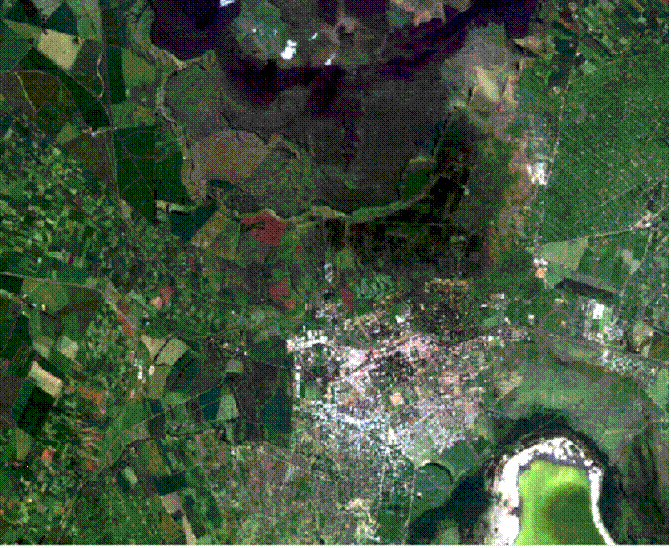
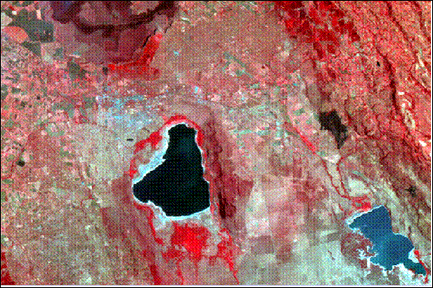
TM
Image
of Bath city, UK
TM Image Band spectral
characteristics Band 1: 0.45 -
0.52 µm (blue). Provides increased
penetration of water bodies as well as supporting analyses of land use, soil,
and vegetation characteristics. The shorter-wavelength cut-off is just below
the peak transmittance of clear water, while the upper-wavelength cut-off is
the limit of blue chlorophyll absorption for healthy green vegetation.
Wavelengths below 0.45 m are substantially influenced by atmospheric
scattering and absorption.
Band 2: 0.52 -
0.60 µm (green). This band corresponds to
the green reflectance of healthy vegetation and is spanning the region
between the blue and red chlorophyll absorption bands. Band 3: 0.63 -
0.69 µm (red). This red chlorophyll
absorption band of healthy green vegetation is one of the most important
bands for vegetation discrimination. In addition, it is useful for soil-boundary
and geological boundary mapping. Band 3 may exhibit more contrast than bands
1 and 2 because the effect of the atmosphere is reduced. The 0.69 m cut-off
represents the beginning of a spectral region from 0.68 to 0.75 m where
vegetation reflectance crossovers occur that can reduce the accuracy of
vegetation studies. Band 4: 0.76 -
0.90 µm (near infrared). For reasons discussed
above, the lower cut-off for this band was placed above 0.75 m. This band is
especially responsive to the amount of vegetation biomass present in a scene.
It is useful for identification of vegetation types, and emphasizes soil-crop
and land-water contrasts. Band 5: 1.55 -
1.75 µm (mid-infrared). This reflective-IR band is
sensitive to turgidity - the amount of water in plants. Turgidity is useful
in drought studies and plant vigor studies. In addition, this band can be
used to discriminate between clouds, snow, and ice which make it important in
hydrologic research. As well as being able to remove the effects of thin
clouds and smoke. Band 6: 10.4 -
12.5 µm (thermal infrared). This band measures the
amount of infrared radiant flux (heat) emitted from surfaces. The apparent
temperature is a function of the emissivities and true (kinetic) temperatures
of surface objects. Therefore, band 6 is used in locating geothermal
activity, thermal inertia mapping, vegetation classification, vegetation
stress analysis, and in measuring soil moisture. Band 7: 2.08 -
2.35 µm (mid-infrared). This band is used to
discriminate between geological rock formations. It is particularly effective
in identifying zones of hydrothermal alteration in rocks. Landsat MSS
(Multispectral
Scanner) The
objective was to provide repetitive daytime acquisition of high-resolution,
multispectral data of the Earth’s surface on a global basis and to
demonstrate that remote sensing from space is a feasible and practical
approach to efficient management of the Earth’s resources. Each pixel in an
MSS scene represents a 68 m x 82 m ground area, while each pixel in a TM scene
represents a 30 m x 30 m ground area (except in the case of the far-infrared
band 6 which uses a larger 120 m x 120 m pixel) An
ordinary digital camera records only blue, green, and red brightness values
corresponding to the range of human vision. The
Landsat MSS sensor has 4 bands that simultaneously record reflected radiation
from the earth's surface in the green, red, and near-infrared portions of the
electromagnetic spectrum. The multispectral scanner (MSS) was the primary
sensor on Landsats 1-3 and was included on the Landsat 5 platform to provide
continuity with previous Landsat data. However, the routine collection
of MSS data was terminated in late 1992. The MSS sensor images a swath
185 km (115 miles) wide. Each pixel (picture element) in an MSS scene
represents a 68 m x 82 m ground area. This sensor has 4 bands that
simultaneously record reflected radiation from the earth's surface in the
green (band 1), red (band 2), and near-infrared (bands 3 and 4) portions of
the electromagnetic spectrum. The characteristics of the MSS bands were
selected to maximize their capabilities for detecting and monitoring
different types of earth's resources. For example, MSS band 1 can be
used to detect green reflectance from healthy vegetation, and band 2 is
designed for detecting chlorophyll absorption in vegetation. MSS bands
3 and 4 are ideal for recording near-infrared reflectance peaks in healthy
green vegetation and for detecting water-land interfaces. Band spectral
characteristics: For
the MSS instruments on board LANDSATs 1 and 2, the four spectral channels are
located in the green, red and infrared portions of the spectrum:
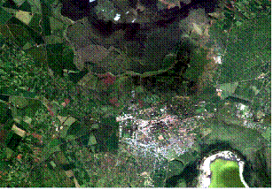
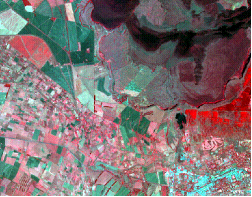
MSS
Image of
|
|||||||||||||||||||||||||||||||||||||||||||||||
|
Conclusions We can conclude from this paper that after Clark labs
developed Idrisi program for the analysis and display of digital spatial
information, it became easier for people to display their own images from
their personal computers without needing to go to professional labs. This
program also became popular as an academic tool for teaching the principle
theories behind GIS in colleges and universities. In some instances it may be necessary to form a mosaic of
several LANDSAT scenes, by matching several images together at the
edges. List some of the problems. Using information given in the text, calculate the number
of pixels for a single band of an MSS scene, for a TM scene. Recompute the numbers to include all bands
available for each sensor. The use of these transformations depends on the objective
of the investigation and the general geographic characteristics of the
application area. They all have the major weakness of not being able to
minimize the effects of the soil background. This means that a certain
proportion of their values, negative or positive, represents the background
soil brightness. |
|||||||||||||||||||||||||||||||||||||||||||||||
|
References
Remote Sensing of the
Environment, John R. Jensen, 2000 page (333,342,349). http://iic.gis.umn.edu/finfo/land/landsat2.htm (Accessed 15.04.2009). http://en.wikipedia.org/wiki/Muhammad_al-Idrisi
(Accessed .19.04.2009). |