| Title Vernal Pool Restoration Assessment Techniques | |
|
Author Ian Boyd American River College, Geography 350: Data Acquisition in GIS; Spring 2009 Contact Information (ijeb27@hotmail.com) | |
|
Abstract The process of evaluating property for wildlife habitat restoration and creation for mitigation purposes is examined by analyzing data collected through federal and local government agencies. Data that was analyzed reflect physical site conditions pertaining to soils, wetlands, flora and fauna that exist on and near the property. Generalized data were collected by uploading from public access internet sources. This data was compared to on the ground surveys that were performed and obtained from private sources willing to contribute for educational purposes. For the most part, the field surveys confirm the results from the generalized data, but in some instances they included pertinent information needed to make sound conclusions. | |
|
Introduction Butte County, California contains some of the most unique habitats in California and the world. One such rare and endemic natural community that exists in Butte County is vernal pools. Near the Butte County-Tehama County border there is a piece of property that is privately owned, but is being considered as a conservation easement for offsite mitigation to impacts to wetlands by the Butte County Association of Governments (BCAG). The property is located in an area north of Chico, California that should be suitable for vernal pool restoration and non-habitat wetland creation. In order to confirm that this site is appropriate for wetland restoration and creation, site assessments need to be performed. The most limiting factor to creating vernal pools is the presence of appropriate water restrictive layers. Spatial data from the Natural Resource Conservation Service should assist in determining what soil properties are on the site and where appropriate areas to construct vernal pools are. Information from the Department of Fish and Game’s California Natural Diversity Database will also play a role in understanding the potential for selected plant and wildlife species to occur on the site once necessary habitat is created. This is only a general approach to assessing a site for habitat mitigation potential. Typically more detailed onsite assessments are needed that utilize GIS approaches and will be discussed in further detail later in this report. | |
|
Background Vernal pools are temporary wetlands that fill with water during the winter, gradually dry down through spring, and remain completely dry through the summer. The annual life cycle of flood and drought creates extreme micro conditions for the plants and animals that live in them. Geology and hydrology play important roles in the formation of vernal pools. Vernal pools are underlain by an impermeable soil surface called hardpan. This hardpan was created by precipitation carrying minerals such as iron oxide, silica, and calcium carbonates below the soils surface, where the finely granulated mineral fused together. Hardpans are not only impervious surfaces to rain water, but also roots from vegetative material. Vernal pools receive a majority of their water from precipitation and from direct surface runoff. Occasionally vernal pools can receive water through interflow, where infiltrated water moves horizontally through subsoil layers above the hardpan. The direct precipitation and runoff (sheet flow) run into the shallow depressions, often running through small cracks in the soil before creating a perched water table allowing the vernal pools to fill with water. Because California has a Mediterranean climate, California vernal pools are inundated in the winter and begin to dry down through the spring. Prior to industrial, agricultural, and community development in California, approximately 4,000,000 acres of vernal pool habitat existed throughout the state. According to Holland in a 1997 study there is less than 1,000,000 acres that still remain. Over the past few decades research has been heavily invested into understanding how vernal pool ecosystems function hydrologically and ecologically. Understanding the physical and biological processes and constraints for vernal pools allows for the possibility for their restoration and creation. Due to environmental laws such as the California Environmental Quality Act (CEQA), the Endangered Species Act, and the Clean Water Act developers of land are required to mitigate for impacts to wildlife, habitat, and environmental quality. Mitigation for environmental impacts requires a lot of planning. The first step is to find a potential site for mitigation and to assess the physical environment that already exists on site in order to ascertain whether that site is adequate enough support the specific acreage required for habitat mitigation. Soils are one element of the site’s physical environment that is examined on the site. The presence and the location of specific soils are critical in being able to design the habitat that is to be created for mitigation. Special species of flora and fauna that may be federally or state threatened or endangered are also important to identify on site or at least within a close proximity. Without the presence of some of these species near the site it is often difficult to get credit from government agencies to incorporate them into the mitigation. The specific site analyzed in this project is privately owned, but would be set up as a conservation easement through BCAG. The site is located just north of Chico, CA and the land’s current and historic uses have primarily been cattle grazing and small agricultural. Although cattle grazing is considered to be beneficial to vernal pool ecosystems by mimicking large grazing herbivores that once existed throughout California (Marty, 2005) , the intensity that cattle are currently grazing the site is detrimental to existing vernal pools. The potential mitigation site is part a larger contiguous land holding totaling over 6,000 acres that may also be developed in the future for other mitigation. | |
|
Methods All GIS data requests to BCAG were directed to the CSU Chico Geographical Information Center. A shapefile of the project boundary was obtained from the CSU GIC and was provided to me for educational purposes. Other data that was obtained from BCAG through the CSU GIC were soil pit locations with associated data forms and locations of vernal pool invertebrates already existing onsite with a wetland delineation. A five mile CNDDB analysis was obtained from BCAG and was originally created using data that indicates the location of special flora and fauna that could exist in the vicinity of the site. BCAG created this analysis by using a specialized database called Rarefind 3. The data was displayed over a USGS topo map and a buffer zone was created up to five miles away from the edges of the site. Inside the buffer all occurrences were displayed on the map. The CNDDB analysis displays occurrences within five miles of an overall property holding that includes the specific potential mitigation site. The site is located in the south western corner of the overall property holding. Aerial photographs, and soils data for Butte County were downloaded from the NRCS Geospatial Data Gateway . When downloading data from this one stop data shop an option to convert the coordinate system and projection was available. I downloaded the data as UTM Zone 10, CA State Plane Zone 2 because that is the coordinate system and projection that the data obtained from BCAG was provided in. Using the aerial photographs as the base map, I overlaid the soils data and the site boundary. Another map showing the location of the soil pits was created, as well as a map showing the delineated wetlands onsite and crustacean locations. These layers were overlaid on top of aerial photographs individually because it is easier to analyze all these components side by side instead of overlaying everything in one map, which creates a cluttered appearance. Along with GIS data, I created a custom soil report for the potential mitigation site This report was done by visiting the NRCS Web Soil Survey and using a Geographic User Interface to select an area of interest (AOI). After selecting the AOI a PDF was downloaded with soil information specific to the AOI. | |
|
Results The NRCS soils data reveals that there are four major soil series present on the site. The upper terrace of the site is composed of the Redtough-Redswale Complex 0-2 percent slopes (302). The lower terrace is composed of the Redsluff Gravelly Loam, 0-2 percent slopes (300). Other areas adjacent to an intermittent branch of Rock Creek are made of Redtough-Fallager-Anita, Gravelly Duripan Complex, 0 to 3 percent slopes (606) and Xerofluvents, 0 to 4 percent slopes frequently flooded (991).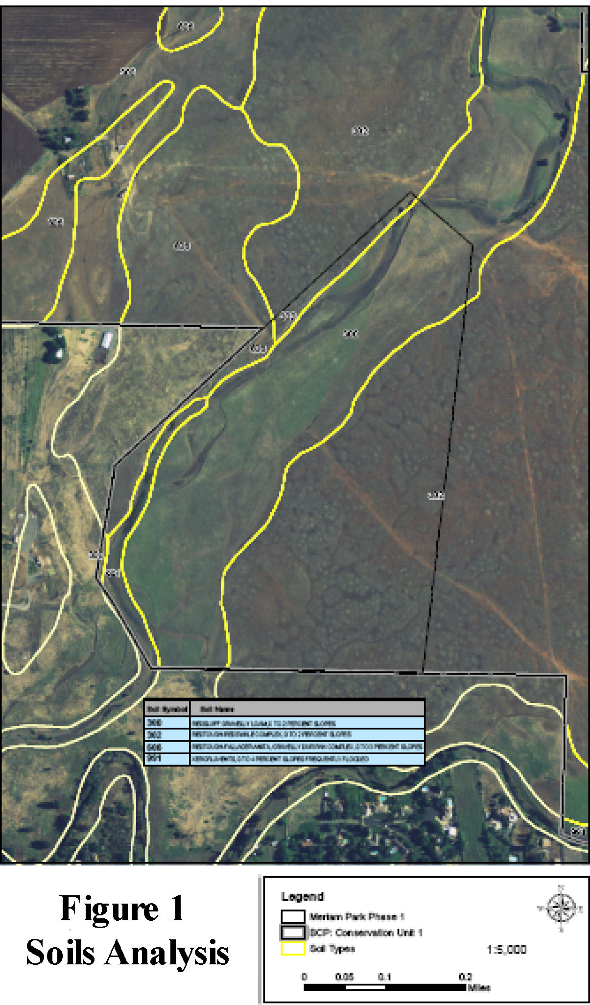 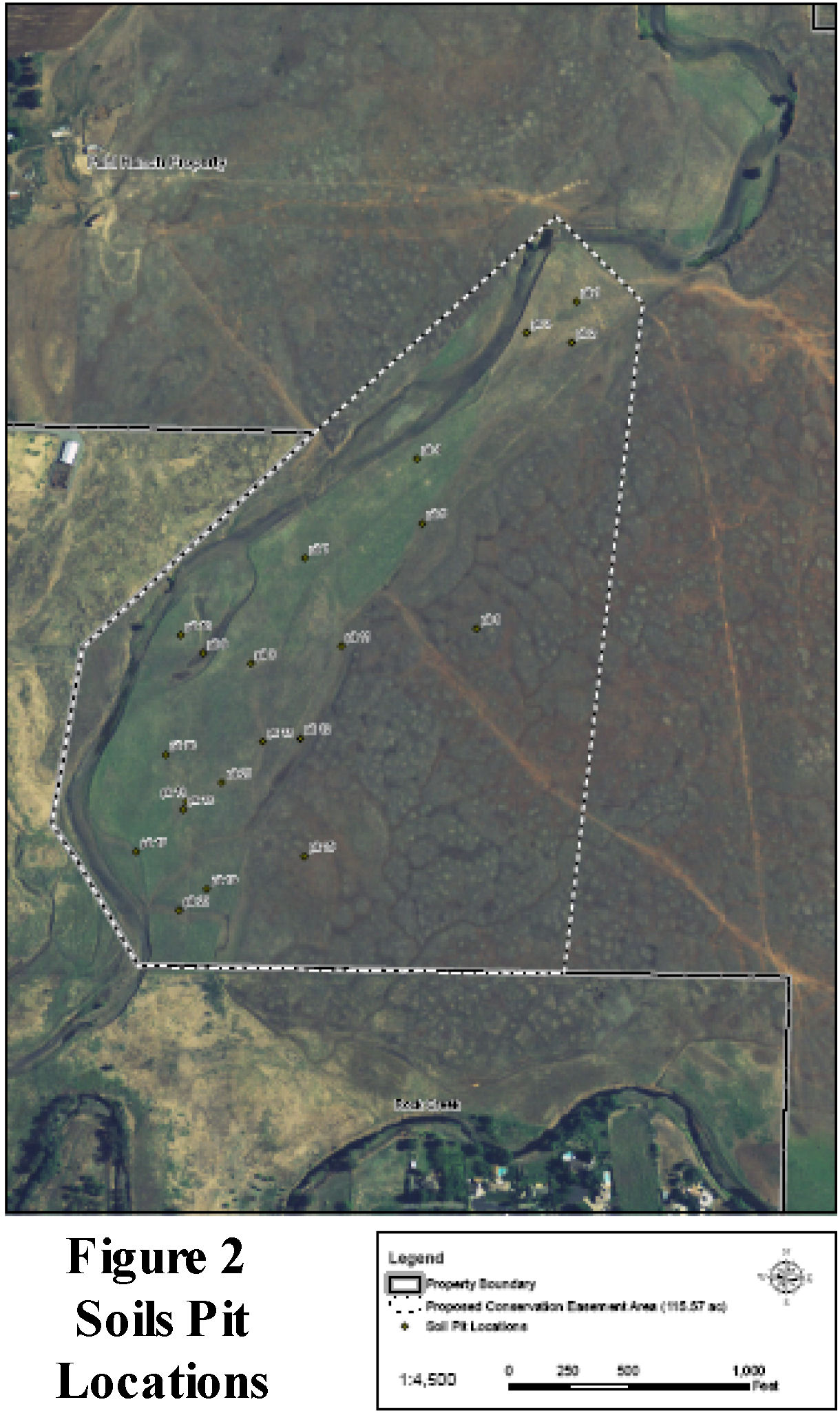 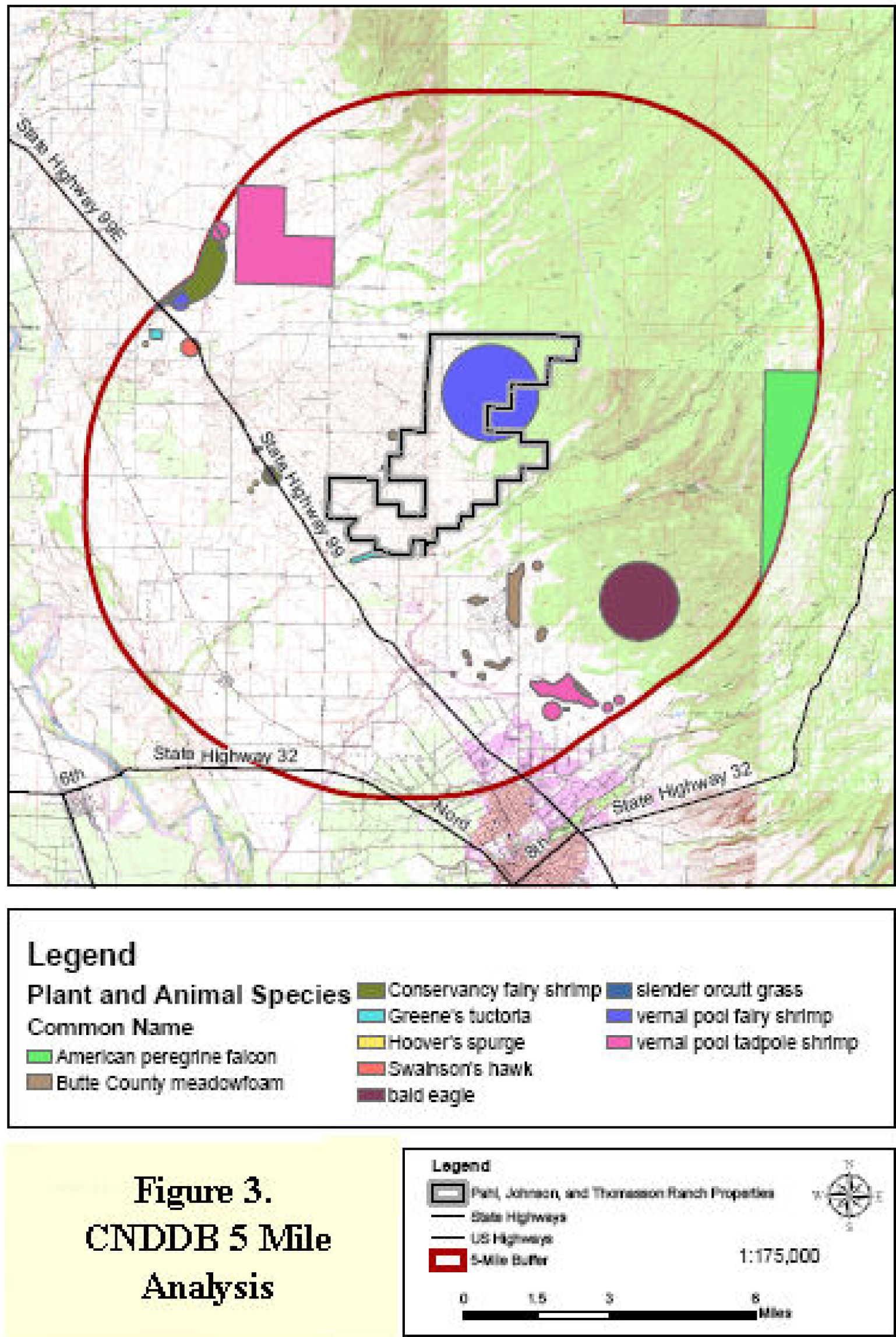
| |
|
Analysis Upon reviewing the soil characteristics from the custom soils report created the soils series 300 revealed that the soils primarily consist of gravelly loam with some clay down to 37 inches below grade. Extremely gravelly sandy loam exists beyond 37 inches to 80 inches below grade. The drainage class for this soil is moderately well drained with no frequency to ponding and a rare frequency to flooding. The depth to its water restricting layer is more than 80 inches below grade. Through soil pit analysis 19 pits were made in the area mapped as soil series 300. Of the 19 pits created on the lower terrace, 8 pits determined that there were areas that consisted of inclusions of anita clay and were underlain by a duripan horizon. These areas were identified in the field as having shallow depressions consistent of remnant vernal pool swales and pools. These areas would be most suitable for vernal pool restoration and creation because the ability to excavate minimal topsoil is feasible. Areas consisting of gravelly loams with water restrictive layers below 80 inches would not be feasible for excavation in order to create vernal pools and seasonal wetlands.Areas that were mapped as soil series 302 from NRCS data consisted of loam, gravelly loam, very cobbly loam, and cemented very gravelly material down to 13 inches below grade and sometimes up to 7 inches below grade. These areas are somewhat to poorly drained soils that have no frequency to flooding, but do have a moderate frequency to ponding. Results from the soil map layers indicate that these areas would be the most suitable for vernal pool creation. The remaining two soil pits were created in the higher terrace areas mapped as soil series 302. Results from analyzing these two soil pits revealed that these areas are underlain by a heavily cemented duripan and would be suitable for vernal pool creation. The five mile CNDDB site analysis that was obtained from BCAG shows the occurrences of special status flora and fauna that potential habitat could be created for within the overall property holding. Upon examination of specific habitat and life history accounts of the species identified in the CNDDB analysis the smaller potential mitigation site could easily accommodate restoration and creation of habitat for the three vernal pool crustaceans, Butte County meadowfoam, slender orcutt grass, Green’s tuctoria, and Swainson’s hawk. All of these species are associated with vernal pool habitat except for Swainson’s hawk (BCAG, 2007) . Swainson’s hawk nest in trees adjacent to bodies of water and forage for small fossorial mammals in grasslands and agricultural fields that are used for the cultivation of high protein grains (Estep, 1989). Native grasses that contain high protein could be installed in areas surrounding vernal pool habitat in the upland areas to attract the fossorial mammals that Swainson’s hawk feed on. The wetland delineation data that was obtained contains the delineation of vernal pools and seasonal wetlands, as well as, the wetland features that contain vernal pool crustaceans. Querying the data for attributes to identify which wetland features are vernal pools and seasonal wetlands I discovered that there are 1.04 acres of wetlands that have crustaceans living in them (0.5 acres of seasonal wetland and 0.54 acres of vernal pools). This information supports the suitability of the site to be used for mitigation for these rare species. The total acreage of existing vernal pools totals 3.0 acres with an additional 1.04 acres of seasonal wetlands. 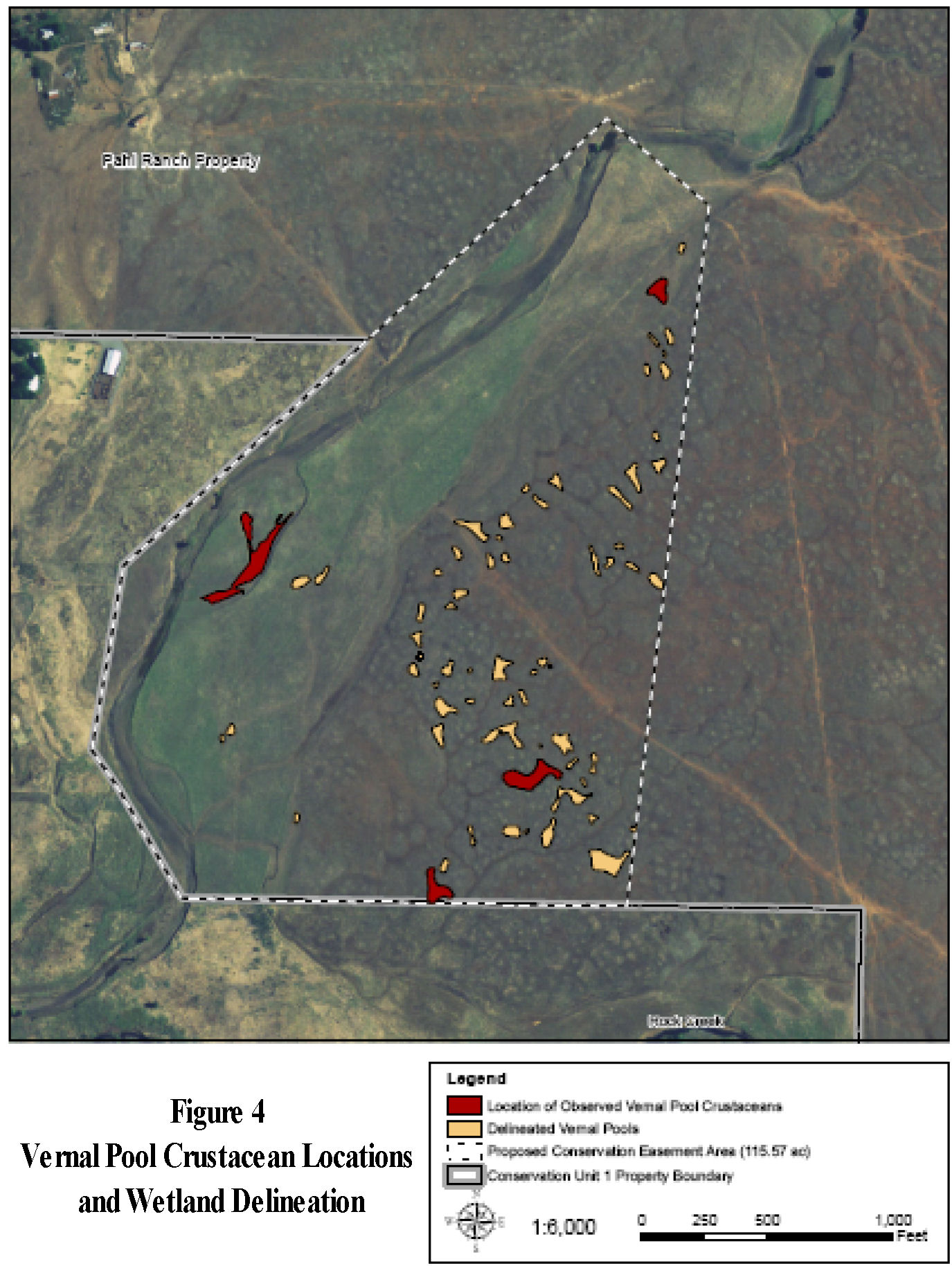
| |
|
Conclusion The use of various types of data provide strong evidence that the site is suitable for mitigation for vernal pools and seasonal wetlands. The site also has potential for other habitat types because it borders an intermittent stream, agriculture, and grasslands that could support Swainson’s hawk. This conclusion was made through analyzing GIS data collected through public sources and private entities. Soils data that was collected through the NRCS provided polygons of the soils in Butte County. It should be understood that this information alone would not support a valid conclusion about the soils on the site because soils are very complex and are not confined to straight lines along the boundary of a polygon. These layers were created by the NRCS in an attempt to capture the variability of soils throughout large areas by generalizing the constituents into polygons. The validation of this data is extremely necessary to create significant conclusions. By performing field surveys of the soils it was discovered that there were areas that would be appropriate for wetland restoration that the generalized data did not support. The similar situation was evident when analyzing the CNDDB analysis. The locations or occurrences of the species presented on the CNDDB data should not necessarily be discredited, but it should be understood that the data is not all inclusive. The data demonstrates occurrences of species at one given time and not necessarily permanent locations. Animal and plant species can migrate and move typically occupying different areas all the time. Once again it was necessary to perform field surveys for vernal pools crustaceans in order to verify there existence on site. Typically more surveys would also be performed in order to understand the biotic potential of the site. These surveys would include raptor bird surveys and botanical surveys, which could reveal the presence of more mitigation potential.Even wetland delineations are a matter of opinion. Professionals will often debate the validity of delineations because they are typically left up to opinion. The Army Corps of Engineers has developed guidelines to use when performing delineations, however, botanists will often vary their results based on their understanding of the plants that exist in and near wetlands. The validity of a wetland delineation would have to be weighed against the credentials of the professional who performed them. After the physical environment is analyzed for the mitigation potential of a site the next step is to use all of this information to design the mitigation. This requires the designer to understand the information that was collected in order to make precautions when designing around and near existing wetlands. The design must also create habitat that will function naturally by utilizing ecological processes. Typically mitigation is performed for impacts that have already occurred and the required acreage of wetland mitigation is already known, however, mitigation banking is a concept currently practiced today that creates sensitive wildlife habitat before it is impacted and credits are sold off as the impacts occur and mitigation is needed. | |
|
References Butte County Association of Governments (BCAG). 2007. Draft Butte Regional Habitat Conservation Plan & Natural Community Conservation Plan/Ecological Baseline Report/Natural Communities. Accessed March 8, 2009. http://www.buttehcp.com/Document/Admin_Draft_Ecological_Baseline_Report.htmlEstep, J. A. 1989. Biology, movements, and habitat relationships of the Swainson’s Hawk in the Central Valley of California, 1986-87.Calif. Dept. Fish and Game, Nongame Bird and Mammal Sec. Rep., 52pp. Holland, R.F. 1998. Changes in Great Valley Vernal Pool Distribution From 1989-1997. Sacramento, CA. Technical Report Prepared for the California Department of Fish and Game, Natural Heritage Division. Marty, Jaymee T. 2005. Effects of Cattle Grazing on Diversity in Ephemeral Wetlands. Conservation Biology 19(5):1626-1632. USDA Natural Resources Conservation Service. 2009. Geospatial Data Gateway. Accesses March 27, 2009. http://datagateway.nrcs.usda.gov USDA Natural Resources Conservation Service. 2009. Soil survey of Butte County, California.Web Soil Survey. Accessed March 29, 2009. http://websoilsurvey.nrcs.usda.gov/app/. (From the original survey: Soil survey of the Butte area, California, parts of Butte and Plumas counties.) | |