|
Introduction
My goal for the project is to look at how GIS is used for determining what areas of Sacramento
will be affected when it floods. Whenever Sacramento gets a storm I have seen and heard on the news of streets, neighborhoods, homes and businesses
being flooded. What neighborhoods are most in danger? What steps are being done to save lives, homes and businesses? What level are the levees
built to? I've been working in the civil engineering field over 10 years. A question that always pops up is, is this project in a flood zone?
Back in the 1860's, Old Sacramento had a catastrophic flood. The city built up the original ground level, to the current street level, of which
we see today. Therefore, what is now currently the basement of the businesses of Old Sacramento used to be the original ground floor of businesses
and homes. Still today, the Sacramento area is no stranger to flooding. History has shown it time and time again. When will it repeat?
My initial impression of GIS was that it was a computer aided drafting program with a database tied to it, to create maps for just about anything.
Boy, was I wrong! Since then I learned how GIS can be used for many different applications. That intrigued me very much. GIS is such a powerful
tool that it can be used in infinite ways. In this paper, I hope to share what I've learned how GIS is used by local, state and federal agencies
to determine where in Sacramento area will be effected the most when it floods.
|
|
Methods
I started by purchasing flood data from the FEMA Flood Map Store. I purchased Q3 (1996) Flood Data and for
the Sacramento County and Federal Insurance Rate Maps (FIRM) (2008) for the City of Sacramento. Starting with the Q3 Data, I had to convert the
files from “E00” format to “SHP” format. After converted the Q3 flood zone data. I catagorized flood zones to see an overal all picture of Sacramento County.
Flood Zones:
- Zone "A" - An area inundated by 100 year flooding, for which no base flood elevations have been established. (High risk zone)
- Zone "X500" - An area inundated by 500-year flooding; an area inundated by 100-year flooding with average depths of less than 1 foot or with drainage areas less than 1 square mile; or an area protected by levees from 100-year flooding. (Low Risk Zone)
- Zone "X" - An area that is determined to be outside the 100 and 500 year floodplains. (Low Risk Zone)
- Zone "ANI" - An area that is located within a community or county that is not mapped on any published FIRM.

As you can see in the figure most of the flooding occurs along the Sacramento and Consumes River
Now I want to focus on the City of Sacramento. What I want to know is which community would be most impacted. I started off by referencing in the community boundaries and assigning each community a unigue color. The I overlayed the Q3 100 year flood data, then overlayed the city limits of Sacramento and finally the American and Sacramento River.

As you can see most of Sacrament will be flooded. North & South Natomas, Downtown, Land Park/Pocket/Meadowview, South Sacramento and part of East City would feel the impact of a 100 year storm.
With this much flooding, I wanted to see what emergency services would be impacted. I referenced in the Sacramento facilities point file in to the my map. Next I selected only major hospitals, police and fire stations. Finally I performed another overlay analysis to see which emergency service are in the 100 year flood zone plain.

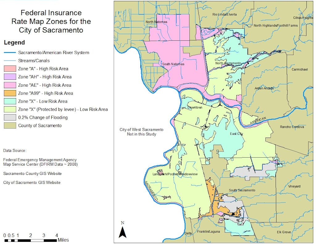
Since the Q3 data is over 10 years old. I want use more up to date and accurate data. The Federal Insurance Rate Maps (FIRM) where recently updated in 2008. For this part of my research I first used Sacramento County base map. Then I overlayed the FIRM data and catagorized the data by zone type. After this I then overlayed water sources; rivers, streams and canals. Finally I then overlayed the communities layer.
Flood Zones:
- Zone "A" - An area inundated by 100 year flooding, for which no base flood elevations have been established. (High risk zone)
- Zone "AH" - An area inundated by 100-year flooding (usually an area of ponding), for which base flood elevations have been determined; flood depths range from 1 to 3 feet. (High risk zone)
- Zone "AE" - An area inundated by 100-year flooding, for which base flood elevations have been determined. (High risk zone)
- Zone "A99" - An area inundated by 100-year flooding, for which no base flood elevations have been determined. This is an area to be protected from the 100-year flood by a Federal flood protection system under construction. (High risk zone)
- Zone "X" - An area that is determined to be outside the 100- and 500-year floodplains. (Low Risk Zone)
 As you can see North and South Natomas and part of South Sacramento are high risk area.
of being flooded in a 100 year storm.
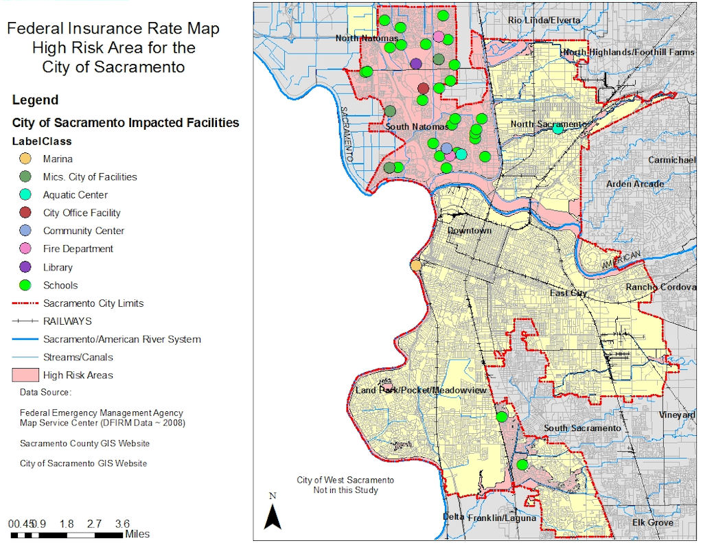
Finally, Since the impacted area is smaller. I wanted to what city facilities would be effected. By selecting the high risk areas only and the Sacramento facility point file and running a overlay analysis on them. This will show me all the facilities that will be impacted.

As you can see, there are only two fire stations in the 100 year flood zone. Most of the other effected buildings are schools and offices etc.
|
Analysis
The method I analysis the data was very simple. I used ArcMap to perform a overlay analysis with the data I had gathered from FEMA, City of Sacramento and Sacramento County. By reading the metadata, I was able to catagorize the zones by risk factor and only using the high risk zones to determing the effected communites. Finally, by using the high risk zones and overlaying those with Sacramento Facilities point file. I was then able to see what public facilities would be effacted. Coming from an engineering background, I knew the most accurate data would come from FEMA. Since the Q3 data was over ten years old, I simply use it for basic overall view of the flood zone for Sacramento County. Since my main concentration was on the City of Sacramento boundary. I was able to obtain FIRM maps that were updated in 2008. I feel very confident with the data that was provided to me is accurate and update.
|
|
Conclusion
It is my humble opinion that North, South Natomas and part of South Sacramento and Meadowview have a higher risk of flooding if there was a 100 year storm to hit Sacramento. Until the levees have been repaired I suggest home owners in the high risk areas take these precautions:
- Carry flood insurance on their homeowners policy
- Have an emergency supply kit containing the following: copies of prescription medications and medical supplies, Bottled water, a battery-operated radio and extra batteries, a first aid kit, a flashlight,Copies of important documents: drivers license, Social Security card, proof of residence, insurance policies, wills, deeds, birth and marriage certificates, tax records, etc.
- Place check valves on all drains
- Plan places where your family will meet, both within and outside of your immediate neighborhood.
|
|
|
|


 As you can see North and South Natomas and part of South Sacramento are high risk area.
of being flooded in a 100 year storm.
