| Title Using GIS to Eradicate Malaria in Kenya | |
|
Author Jack Hunt American River College, Geography 350: Data Acquisition in GIS; Spring 2010 Contact Information (Email: huntjw@imail.losrios.edu) | |
|
Abstract For thousands of years malaria has wreaked havoc for the people living in Kenya. Mosquitoes are the primary culprit for transmitting the disease, and preventing bites has become the main objective. Bed nets and anti-malarial drugs are the first line of defense for the people of Kenya. Modern technology has brought Kenya GIS technology. Using GIS Kenya can access important map information to better understand how effective their defense measures are. My research is designed to highlight how important GIS technology is for malaria defense in Kenya. I used online databases along with various books that contained information pertaining to GIS, malaria, and mosquitoes. What I discovered was a very clear picture of the important role that GIS plays in malaria prevention for Kenya. I could see the results in both the GIS maps and the statistical information provided by the data collected using GIS research. | |
|
Introduction Malaria is a deadly disease that has plagued the country of Kenya for far to long. The disease is spread by mosquitoes, and the human bodies' reaction to the dangerous parasite can easily lead to death. Various techniques have been implemented in order to prevent and cure malaria in Kenya. For example, bed nets can be used to prevent mosquito bites,and anti-malarial drugs can be used to cure people who have been infected with malaria.Over the years these techniques have proven their worth; however the need for additional resources has become very clear.Modern technology has given the world access to a powerful tool, and that tool is Geographic Information Systems (GIS). GIS technology can be used to monitor the effectiveness of malaria prevention techniques, and possibly eliminate one of Kenya's most deadly diseases. I will utilize my data acquisition skills to compare various maps and strategies in order to understand the important role that GIS technology plays in helping the people of Kenya become malaria free. | |
|
Background While malaria occurs all over the world, Africa is by far the most impacted. According to the Bill and Melinda Gates Fountation, malaria causes over 1 Million worldwide deaths per year, and 90% of them are in Africa. In addition, 85% of those who die are children under 5 years of age. | |
| I have had a growing interest in understanding the importance of GIS
technology for global health. An article in ArcUser online titled
"Spacial Analysis Optimizes Malaria Prevention Measures"(2005) was an excellent motivation for me to research the topic further.
In the article Allen Hightower observes the challenges and discoveries seen by public health researchers who used GIS to track malaria
in Kenya during the late 1990's. GPS units were used to map out the villages in Kenya where research was needed. The public health
researcher's discovered that the bed nets generated significant results in all statistical categories. This data was very helpful, especially
for those who did not see the importance of using bed nets. Ellen Cromely's book "GIS and Public Health"(2002) was another great resource. The book helped me understand the importance of tracking soil moisture and comparing it to mosquito hotspots. Another big motivation of mine was driven by the sympathy that I feel for the millions of unwealthy people that malaria has infected. These people do not even have the money to afford help when they need it. In a Discover Magazine article, ("It's Time for a new Global War on Childhood Disease")Yachi Yamada points out "I don't believe just because you're poor, you shouldn't have access to lifesaving technology."(qtd. in Discover 2010) My research helped me see the great possibilities that GIS provides for malaria research in Kenya. |

|
|
Methods My research for this project was a combination of information gathered from web sources and books that I have recently read. I also dicovered many helpful maps during the process of gathering this information. | |
| The Gates Foudation and
Centers for Disease Control and Prevention were both my primary sources for the statistical
information in my project. Everything from past to present death rates, and current intervention techniques were easily accessible
through these web sites. The first step in my research was to compare maps of Kenya. I searched google images to track down usable maps that compared population density, malaria outbreak,and precipitation. I was suprised how similar the results were. Every piece of data I collected was handled like a puzzle piece. At first it was confusing and disorganized, but quickly became clear and understandable. I used the information found in Ellen Cromely's book"GIS and Public Health"(2002) to aid my research in understanding mosquito habitat, and other GIS information pertaining to malaria studies. |

|
|
Results My research gave me a lot of data to compare. I quickly realised that the best way to
attain a comprehensible outcome for comparing data, was to start with understanding what the maps were conveying. And then compare
the results to statistical figures. | |
|
|
My goal was not just to highlight the problem, but to show how GIS has been a key factor in improving the malaria epidemic in Kenya.
The map statistics were created using GIS software to compare the specific problem areas that needed immediate action. When the
Centers for Disease Control and Prevention did a study to show how effective bed nets were
in creating a strong defense against mosquito bites in the late 1990's, they discovered how important GIS technology was to their research.
I found GIS to be a very effective resource to provide accurate data for fighting off Kenya's malaria epidemic. S.I. Hay, author of
"Remote Sensing and Geographical
Information Systems in Epidemiology" acknowledges that "Maps provide a powerful lobbying tool and contribute towards planning and
monitoring malaria control operations through community health care, targeted insecticide spraying and drug distribution."(203)
Kenya's economy also greatly benefits from GIS technology. For example, since GIS aids the effectiveness of malaria prevention it can then subsequently repair Kenya's economy because more people will be healthy enough to work. |
|
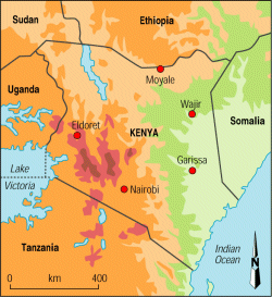
Figures and Maps Since malaria is most commonly
spread by mosquitoes, it can be tracked by climate change. For example, GIS technology
can store data that identifies not only rainfall but also areas of high soil moisture.
These are areas where hordes of mosquitoes are found. According to Ellen Cromley,
"modelling soil moisture and lagged soil moisture sustainability improved prediction
of variability in bite rates over the predictions made from rainfall alone."(229)This information gave me the idea to compare these two maps. The left map represents the precipitation, and the right map represents the malaria infection hotspots. | |
 |
|
|
Analysis I believe that the data I collected gives an observer
a good understanding of the seriousness of malaria in Kenya. However, it proved to be a challenging
project in many ways. For example, I was unable to gather the layer data to create a map that I
felt represented a good example of malaria infection improvement using GIS. As a result, I found that Africa is much more
difficult to acquire data than that of an American region. The bulk of the data in my project is an observation
of the aquisition done by various GIS analysts'.I overcame the lack of designing my own map by seeking out maps that closely represented the message I was trying to convey. This was surprisingly more time consuming then making a map myself. However, my results were interesting to compare. I most enjoyed using the precipitation map to compare its similarities to the malaria outbreak and population density maps. It was interesting an intriguing to see that nearly all of the information that I found while researching malaria was targeted at mosquitoes. When I compared the useful data represented on the maps of Kenya, and the statistical information identifying the malaria infection rates dropping by up to 50%, I was surprised to find that there was not a lot of praise or recognition for how helpful GIS technology has been in reaching such an incredible achievement. It seems as if GIS plays a silent hero role for Kenya, and its battle against malaria. I for one hope that the heroic image that GIS deserves becomes more clear to everyone in the future. | |
|
Conclusions Techniques such as using bed nets to prevent mosquito bites and anti-malarial drugs
to cure the disease have proven to be effective. However, without the use of GIS technology, the people of kenya will fight malaria
blindly. They will not be able to accurately track the positive impact of the solutions implemented, or be able to clearly understand
the complexity of each infected location. The fight to release malarias strong grasp upon Kenya's beautiful country has been a long one;
but if GIS technology is used to its full potential perhaps Kenya can finally escape the clutches of one of history's most deadly diseases. | |
|
References "All lives have equal value". Global Health: Malaria,2010. Gates Foundation Online, Web. 21 Nov.2010. "Centers of Disease Control and Prevention".CDC: Malaria facts, Web. 21 Nov. 2010. Cromely, Ellen K., and McLafferty, Sara L. GIS and Public Health.New York: Guilford, 2002. Print. 11 Nov. 2010. Gwadz, Bob. Malaria in Africa: an overview. AAAs Annual Meeting. Web. 21 Nov. 2010. Hay, S.I., Randolph, S.E., and Rodgers, D.J. Remote Sensing and Geographical Information Systems in Epidemiology. Boston: Academic, 2000. Print. Advances in Parasitology. Vol. 47.11 Nov. 2010 Hightower, Allen."spatial Analysis Optimizes Malaria Prevention Measures". National Center for Infectios Disease.2005. ESRI Online. Web.11 Nov. 2010. Lang, Laura. GIS for Health Organizations . Redlands: ESRI, 2000. Print.11 Nov. 2010. Yamada, Tachi. "It's Time for a new Global War on Childhood Disease."Editorial. Discover Magazine. Vol.31. May. 2010. Web. 11 Nov. 2010. | |
