Title
| ||||
|
Author American River College, Geography 350: Data Acquisition in GIS; Spring 2011 manbecks87@gmail.com | ||||
|
Abstract | ||||
|
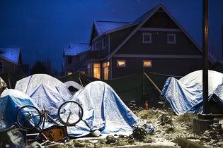
Introduction Since then, Safe Ground has worked hand in hand with city officials to gain insight into the needs of those living on the streets. One of thier biggest effort so far is attempting to establish a permanent site where camping is legal. Their proposed land development includes fifty to one hundred semi-permanent cabins with communal kitchen, eating and restroom facilities. Boarders would be allowed to stay in the facility for up to eighteen months, granted they follow the zero tolerance policy for drugs and alcohol, which Safe Ground feels the community could self govern. In the words of leader Stephen Waters (2010), Safe Ground Sacramento “is about people seeking to help themselves while trying to survive without many of the benefits of society and about providing Sacramento with a model solution that can be cost effectively repeated elsewhere” . The goal of this project is to identify parcels fitting the zoning, sizing and distance from public transportation requirement set forth by SafeGround Sacramento in their Request for Proposal for Land Development. SafeGround Sacramento believes that, due to Sacramento City’s broad zoning categories, proper permits could be acquired for parcels zoned R, C or M. In unincorporated Sacramento, SafeGround seeks parcels zoned RD-40, SC, LC, GC, CO and DW. They ask that parcel size be between two and five acres and are no more than a quarter mile from established Regional Transit bus and light rail stops. The results of this analysis are intended only for identification of parcels as a preliminary for more in depth studies and possible community outreach. | ||||
|
Background
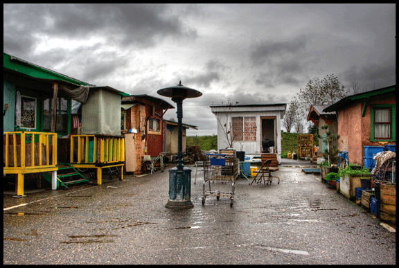
Portland, Dignity Village is one of the oldest established tent cities, having been officially established in 2001 when an existing informal tent city was forced to relocate to Sunderland Yard, a leaf composting site, due to threat of a police sweep. Its location is seven miles from downtown Portland, far away from residential neighborhoods, and contains fifty wooden structures made from recycled goods which house sixty residents. Originally, the camp consisted of tents, teepees and makeshift houses, but over the decade housing has improved to the point that it now meets or exceeds the American Red Cross and Mercy Corps.’ sanitation requirements for emergency relief camps. Dignity Village is completely self sustained as it is self funded and self governed. Although there is a strict code of conduct, including sobriety, non violence, mandatory community service and the opportunity to participate and vote on the community council, there is no screening process for residents, or a time limit on how long boarders can stay. Dignity Village is unique in that it” furthers this sense of ownership and allows the homeless to make both tangible physical and social improvements to their community” that they would other wise not be able to in a mobile or transient environment (NHC, 2010).
Another model for tent cities that is not being considered for Sacramento, but is worth noting, is the rotating model like that of Seattle, Washington's Tent City 3 and Tent City 4 and Olympia, Washington's Camp Quioxte. All three camps rotate from church to church every ninety days and are often located in affluent, residential neighborhoods. Tent Cities 3 and 4 are opperated by the non profit Seattle Housing and Resource Effort (SHARE) along with its sister organization the Women's Housing Equality and Enhancement League (WHEEL), collectively known as SHARE/WHEEL, while Camp Quioxte partners with its local non profit organization, Panza. The partnered non profits are responsible for raising funds, organizing host church locations, working with the internal government of the camps and acting as liason between the camp, the community and the local government. Despite the burden of moving locations every ninety days, rotating tent camps require community involvement and develop awareness and familiarity towards the homeless that is not necessarily present in permanent camps like Dignity Village and River Haven. (NHC, 2010) beleives that it is the combination of community invovlement and the prescense of a strong non-profit partner that gives the camps legitimacy and eventaully gains community support. | ||||
|
Methods Parcels in Sacramento City were isolated by performing the attribute query “CITY”=’SACRAMENTO’ on Parcels_wo_Owners.shp.. Once Sacramento City parcels were isolated, an additional attribute query was performed from the current selection, "ZONE" LIKE'R%' OR "ZONE" LIKE'M%' OR "ZONE" LIKE'C%' AND "LOT_SIZE" >=87120 AND "LOT_SIZE" <=217800 in order to find parcels zoned M, R, C that are between 8,7120 square feet (two acres) and 21,7800 square feet (five acres). Finally, two more spatial queries were performed in order to extract from the selection, parcels within 0.25 miles of bus stops (Bus_Stops.shp) and add to selection parcels within 0.25 miles of light rail stations (Light_Rails_Stops.shp.). A layer was made from selection and then exported to create SacCity_Poss_Parce.shp.. Parcels outside of Sacramento city were identified by performing the zoning and lot size attribute query “ZONE”= ‘SC’ OR “ZONE”= ‘LC’ OR “ZONE”= ‘GC’ OR “ZONE”=’CO’ AND LOT_SIZE" >=87120 AND "LOT_SIZE" <=217800. From this selection “CITY”=’SACRAMENTO’ was removed. The spatial attribute queries for parcels within 0.25 miles of bus stops (Bus_Stops.shp) and add to selection parcels within 0.25 miles of light rail stations (Light_Rails_Stops.shp.) was performed, resulting in the shapefile Poss_Parc_Uncrp.shp.. | ||||
|
Results | ||||
|
Figures and Maps 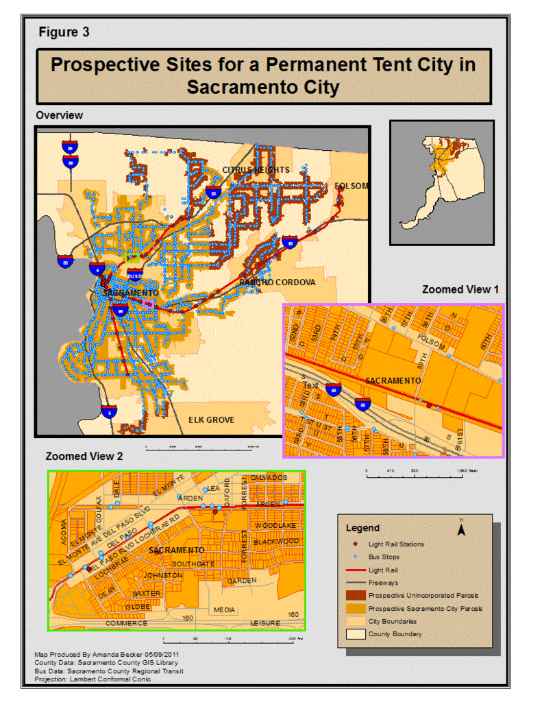 
| ||||
|
Analysis | ||||
|
Conclusions | ||||
|
References Camp Quixote. 5/1/2011. http://quixotevillage.com/ Camp Quixote. "Panza Partnership". 5/1/2011. http://quixotevillage.com/about/panza/ Citizens Info. "Tent City Seattle". Tent City Seattle. 'Sacramento's future may be found in Seattle's tent cities'. 20 March, 2011. http://news.citizensinfo.com/sacramento_ca/sacramentos-future-might-be-found-in-seattles-tent-cities/ Delaney, Arthur and Grim, Ryan. “Tent Cities: An American Tradition”. The Huffington Post. First Posted 06/17/2010. Last Modified 03/23/2011. http://www.huffingtonpost.com/2009/03/19/tent-cities-an-american-t_n_175665.html Dignity Village. 5/1/2011.http://www.dignityvillage.org/ “Editorial: Big Surprise: Blight returns to river”. The Sacramento Bee. Published 1/30/2011. Page 6E.http://www.sacbee.com/2011/01/30/3360930/big-surprise-blight-returns-to.html GTFS Exchange.Shapes.txt.Sacramento Regional Transit.http://www.gtfs-data-exchange.com/agency/sacramento-regional-transit/ Hubert, Cynthia. “Breaking Sacramento’s homeless cycle”. The Sacramento Bee. Published 2/21/2011. Page 1A. Last Modified 2/21/2011.http://www.sacbee.com/2011/02/21/3418106/breaking-sacramentos-homeless.html Hubert, Cynthia. “Fong ‘embarrassed’, Johnson ‘proud’ of Sacramento’s progress on homelessness”. Published 10/12/2010. The Sacramento Bee.http://www.sacbee.com/2010/10/12/3099639/fong-embarrased-johnson-proud.html Hubert, Cynthia. “Sacramento’s nomadic winter shelter deemed a success, but what next?”. The Sacramento Bee. Published 4/6/2011. Page 1A. Last Modified 4/6/2011.http://www.sacbee.com/2011/04/06/3531277/sacramentos-nomadic-winter-shelter.html Hubert, Cynthia. “Sacramento task force plans campground for up to 60 homeless”. The Sacramento Bee. Published 08/18/2009.http://www.sacbee.com/ourregion/story/2117430.html?storylink=pd Kalb, Loretta. “Schwarzenegger, Johnson part toer address homeless issue”. The Sacramento Bee. Published 3/25/2009.http://www.voa-sac.org/LinkClick.aspx?fileticket=XdL13IXFwpA%3D&tabid=3064 Label, Bruce. "River Haven Domes". River Haven Domes. 'Shelter Design For Good'. 6 Oct, 2009.http://docucinema.com/shelter/category/production/ National Coalition for the Homeless. 5/1/2011. http://www.nationalhomeless.org/ National Coalition for the Homeless. Tent Cities in America: A Pacific Coast Report. March 2010. www.nationalhomeless.org.http://www.nationalhomeless.org/publications/Tent%20Cities%20Report%20FI AL%203-10-10.pdf Request For Proposal For Land Development. April 2, 2010. SafeGround Sacramento.Inc. http://www.safegroundsac.org/_pdf/sg_rfp_April_final.pdf Sacramento County GIS Centerlines.shp.. Creates by AutoCAad. 2/2010. http://www.sacgis.org/GISDataPub/Data/ Sacramento County GIS Library. Light_Rail_Lines.shp.. 12/2006. Provided by SACOG. http://www.sacgis.org/GISDataPub/Data/ Sacramento County GIS Library. Light_Rail_Stops.shp.. 3/2007. Provided by SACOG. http://www.sacgis.org/GISDataPub/Data/ Sacramento County GIS Library. Parcels_wo_Owners.shp..Produced by Assessor AutoCad.http://www.sacgis.org/GISDataPub/Data/ Sacramento County GIS Library.Sac_Cities.shp.. 12/2009 http://www.sacgis.org/GISDataPub/Data/ Sacramento County GIS Sac_County_Bound.shp.. 12/2008 http://www.sacgis.org/GISDataPub/Data/ Seaman, Josh. "Dignity Village". Dignity Village. 'Photos by Josh Seaman'.http://www.redsemillaroja.org/Projects/Live%20Debris/LD9artists/DignityVillage.html Seattle Housing and Resource Effort/Women's Housing Equality and Ehnhancement League. 5/1/2011.http://www.sharewheel.org/Home/tent-cities Seattle Housing and Resource Effort/Women's Housing Equality and Ehnhancement League. "Tent Cities". 5/1/2011.http://www.sharewheel.org/Home/tent-cities Turning Point Foundation. 1/5/2011. http://www.turningpointfoundation.org/about_us.html Waters, Stephen.“View Points”: Let’s set the record straight about SafeGround’s goals and motives”. The Sacramento Bee. Published 2/19/2011. Page 11A.http://www.sacbee.com/2011/02/19/3414837/lets-set-the-record-straight-about.html | ||||

 >
>