| Title Effects of Climbing on Inyo and Mono County | |
|
Author Joseph Timothy Myers, American River College, Geography 350: Data Acquisition in GIS; Spring 2011 | |
|
Abstract An overview of an ongoing issue of how climber access is often affected when other public, private, and government entities are brought into the picture. Specifically Mono and Inyo Counties have a plethora of climbing opportunities, but sometimes other user groups have mixed feelings toward the climbing community in general. | |
|
Introduction Mono and Inyo Counties are rich in their respective natural resources and especially rich in their recreational opportunities and endeavors. When it comes to rock climbing, there is no shortage of supply! The Mammoth area is rich in volcanic plugs making for endless routes up overhanging terrain, and the Bishop, CA area is plentiful as well with volcanic mixed climbs such as those found in Owens River Gorge. What I intend to show is the connection between these recreational rich climbing resources and the climbing community as well as the general populace, and how th they factor into the equation through a 3rd person point of view. My desire is to lead the reader into an understanding of how these two communities (climbing comm. and the greater general populace have been able to co-exist and show the spatial properties for these specific areas within Mono and Inyo Counties. | |
|
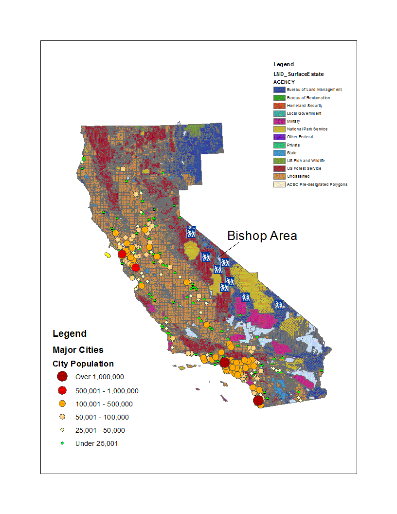
Background There have been many, many issues on climber/general populace interactivity in the past 20 to 30 years. Quite a few have been settled by the Access Fund, a non-profit group dedicated to keeping climbing access available to the general public for present and future years to come. Again, i want to stress here that rather than write on the specific issues within climbing, it is my desire to show the spatial properties of how the climbing world and the general public have already co-existed (often without many people being conscious of it) for years and years now. "clean Climbing" advocates like Royal Robbins and others in the past 50 years have paved the way for the possibility of climbers and those in management (i.e. USFS, NPS, etc.) to peacefully co-exist and often thrive in the same communities. The target areas I'm focusing on here, namely Mono and Inyo Counties are perfect examples of areas where one gets a rich diversity of recreational and management entities dwelling together. Everything from State and National parks like Death Valley, or Mono Lake mean that climbers must and have been able to mutually co-habitate with other user groups in a way that allows for beneficial experiences had by all. There are exceptions and people have blogged about that for years now, but again my aim here is to show the possibilities of what has been, and what could be, given the volumous geographical areas each user group has to play with! | >This map to the right shows the Government agency ownerships for the state of California. I have chosen to focus on the Bishop, CA area because it is so heavily laden with climbing areas around it and most of the land is BLM owned. Bishop receives heavy traffic from tourists, skiers, backpackers, fishers, cowboys, and even more user groups, so it knows the outdoor world well. As you can see, the Bishop area is sparcely populated compared to the other main urban areas of CA which is great because people go to Bishop and areas around for population relief! It shows no real visible signs of turning into a major urban destination anytime soon! |
|
|
Methods Data was collected based on how it correlated to climbing areas within Mono and Inyo Counties. Any data that might affect, in one way or the other, climber access was included. Geo-Spatial data such as population, trails, access issues, whether they be climber related or not, as long as they were directly related (geo-spatially) were included. For this particular project, it seemed appropriate to focus on data that could be visualized cartographically, so atttribute and/or tabular info wasn't really included. Again, as this is on-going research, any and all tabular data that sheds new and informative light on climber access within these two counties would definitely be included provided it is shown to be accurate and cross-checked with our sources in the area. All the climbing data i presented in this project was made by me from scratch by Geo-Referencing other legacy documents of climbing areas, and then making a Feature Class within a new Geodatabase made specifically for this project. Obviously since Geodatabases can store LOTS of data, i will use it to add new data over time as i continue to amass more data from climbers and make it into Geo-Spatial data which can then have tabular and spatial properties which could then be further analyzed for veracity and proper usage. | |
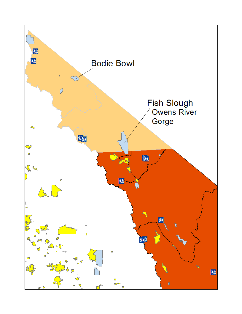
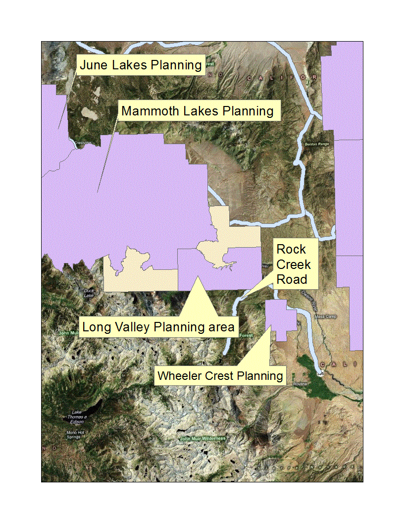
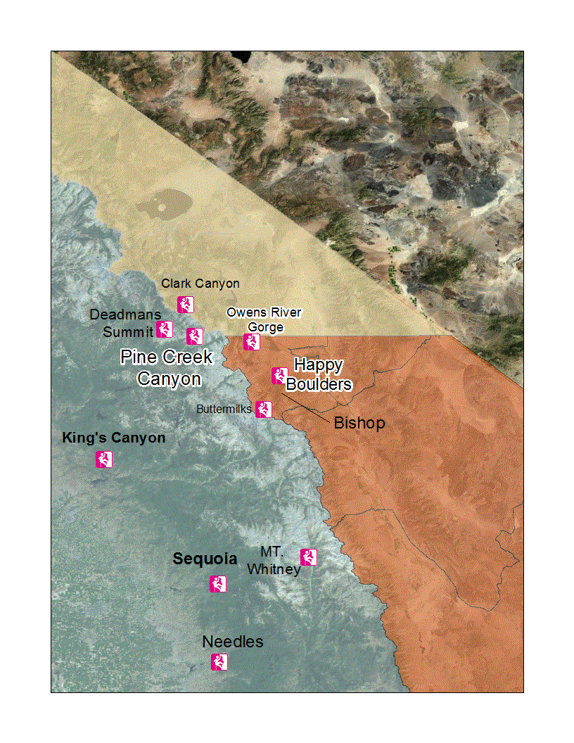
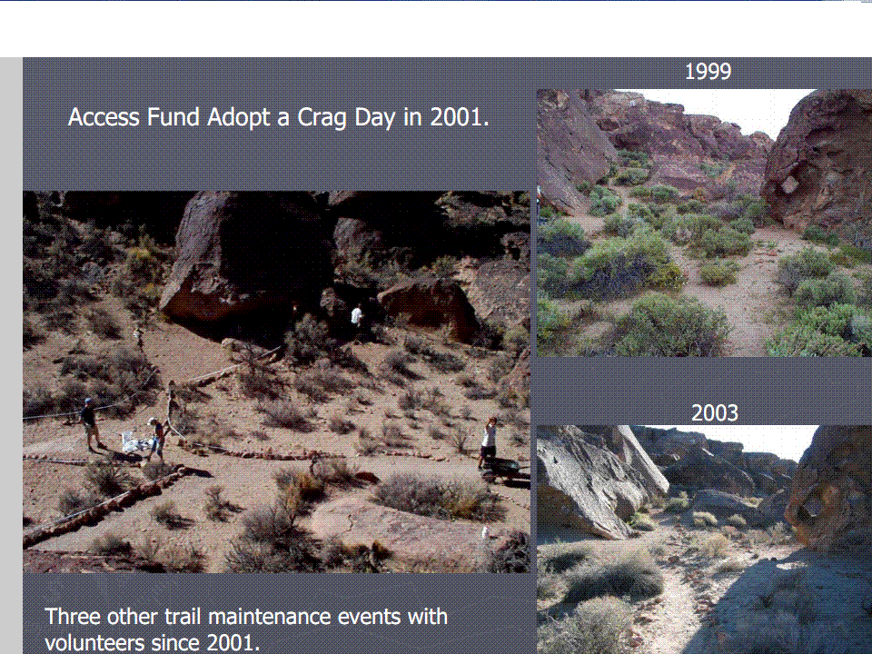
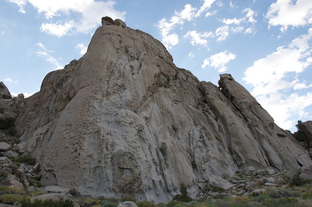
| This map to the right shows a zoomed in version of Mono and Inyo Counties. Yellow polygons are census derived populated centers. light blue polygons are ACEC (Areas of critical environmental concern...Notice that one of the blue polygons is right within the Bishop area! The included trails within the general area don't appear to be affected, but Owens River Gorge is, as it is an extremely popular Sport Climbing area along the Owens River within the Gorge itself. The image below this one shows the Rock Creek area and a new planning division for the Wheeler Crest area! This is surprising as this is actually a wonderful climbing area, and if they do decide to build here, it would be a sad day for many climbers in the Eastern Sierra! As you can see in the map, many areas where there are so sweet climbing areas would be affected, particularly small crags in the Mammoth mountain area as they would potentially continue to build outside of the "lakes" area. Also affected would be areas of Rock Creek road which have a number of cool small crags climbers like to visit from time to time. The next map shows some of the climbing areas on the Eastern Sierra escarpment. Specifically, places like Pine Creek Canyon could face access issues because of building and planning issues around it and the towns around it. I had to Geo-Reference all the climbing areas within CA from a legacy document in order to make a Feature Class that i could then lay down over some imagery and the Mono and Inyo county boundaries, respectively. Areas that have a white Halo around them either have access issues or likely will have some in the future simply because of their location and adjacency with other user group areas like fishing, LADWP, etc. Thankfully NPS areas and Mt. Whitney actually figure to be climbing havens for years to come because they are already preserved and/or specially watched by the USFS. Anyone who has hiked or climbed Mt. Whitney knows that it is an area of close observation by rangers. Also the Happy and Sad Boulders (yes, that is their real names) have historically already encountered some strict rules and regulations to bouldering over there because of the sensitive nature of the area. The area is also home to cultural artifacts such as ancient Native American art calligraphy on the rocks around that area, so climbing on certain areas is prohibited. As the referenced Access Fund article points out, "Chalk Bluff area of the Southern Tablelands contains approximately 33.3 Archaeological sites per Km2." That's quite a bit when you think about how many climbers are in that area! Shown here to the right is an image from the referenced Access Fund PDF that i thought was necessary to show the many hands who go out and try and preserve climbing areas for generations to come. As you can see, these areas receive heavy traffic which definitely changes the landscape over the years, and so it is often necessary to do "restoration" projects and/or direct the traffic so that the surrounding landscape is left unharmed and unchanged by human interaction. This image shown to the right here is Granite Mountain off 120 east of Mono Lake. This area is just one of many one BLM land which means climbers and user groups of all kinds need to be especially careful about doing their part to preserve such wonderful treasures as rangers rarely patrol these areas. |
|
|
Results The particular format that i have chosen to use was to focus alomst entirely upon allowing the viewer a chance to visualize the area of concern cartographically and see things from a map perspective without worrying much for tables, charts, etc. The reason behind this is that the kinds of data I ended up bringing to the table (no pun intended!) are maps showing ownership, usage, features, etc. They are there so that the viewer can see who climbers are dealing with when they go to various places within Mono and Inyo counties. This is an ongoing project and the data will still be accumulating long after i submit this, as this is a huge issue withing the climbing community, it just hasn't reached GIS standards yet! | |
|
Analysis One of the hardest and most daunting things about this project was
to be able to find climbing data of a demographic nature. I knew from the start that this would be quite the ambitious
project and one where i might not initially find all the data i wanted to, but i still wanted to be able to pursue in
and even after presenting in class, i fully intend to keep on accumulating data for Mono and Inyo as well as a variety
of other areas because i believe that a GIS can powerfully display and analyze these types of issues in an effective
manner. I find success in finding data for the areas that pertained to natural science, general population and other
aspects that i did use to show how other user groups are in the area and then extrapolate from there! Almost any
scientific endeavor extrapolates without FULL data to go off of...They make assumptions based on what they have, and here
I have taken up that perspective as well. My alternatives to not having a plethora of climbing data was to augment
my project with as much ancillary data as possible given the time constraints of the project. Again, for me this is
still an ongoing research project and i will keep adding data whenever and wherever i get it, provided it's metadata
can check out of course! So, i really don't look upon the lack of climbing data as a unresolved difficulty, just another
opportunity to gain more in time when i obtain it. | |
|
Conclusions The conclusion is obvious yet not so simple right now. Getting the necessary GIS
data for and from climbers who actually climb, travel, and live the life at least at some point in their lives will take
time..quite a bit of time. I don't intend to give up on it, as it is something that i will accumulate throughout my life as
a GISer. I also think that the data from other agencies could be even better if they consulted various user groups like
climbers or fishermen so as to get a more well-rounded data set that included other "takes" on the environment and user
group participation. On a really bright note, The Access Fund, a Non-Profit Organization supporting keeping climbing access
open has put out a great PDF document illustrating some of the things i have been trying to do in this project. I have
provided a link to it below in the References section as it really puts some access issues into perspective.
| |
|
References Data was compiled using the links provided below from the USFS, Mono County GIS, and references to Access Fund, and their ongoing work to create a sustainable environment for climbers and the general public alike. | |