| TitleHiking and Mountain Biking the North Lake Tahoe Ski Resorts in the SummerNorthstar-at-Tahoe™ Resort and Squaw Valley USA |
|
Author Jone Sconyers American River College, Geography 350: Data Acquisition in GIS; Spring 2011 | |
|
Abstract Lake Tahoe California has approximately 14 ski resorts in the area, which are known world wide for it's snow skiing. Not only do the ski resorts provide wonderful snow activities, the summer months are full of fun too. Some of the ski resorts such as Northstar-at-Tahoe™, near Truckee California, run their chairlifts in the summer carrying people up the mountain for hiking, mountain biking, restaurant services and many more activities. Using GIS to show which ski resorts and what activities are available would be very useful and informative to summer visitors. This project will concentrate on two well known resorts in the northern Lake Tahoe area, Northstar-at-Tahoe™ and Squaw Valley USA ski resorts, and two of the popular sports, mountain biking and hiking. | |
|
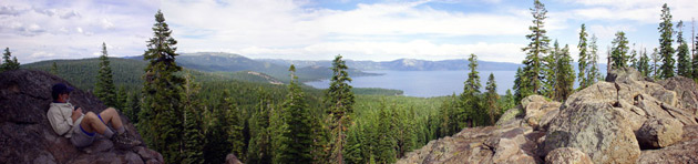
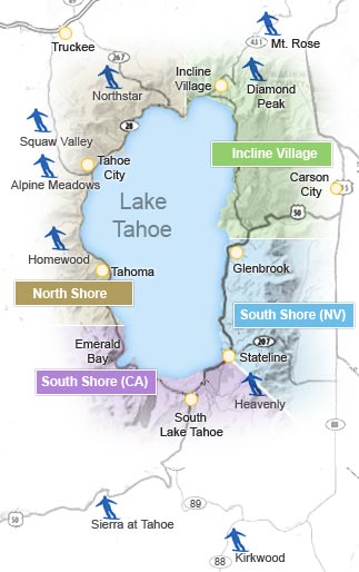
Introduction Northstar-at-Tahoe™ Resort (Northstar) is located 7 ˝ miles to the southeast (UTM 10 S 749738m E 4352713m N, base elevation 6330 ft) from downtown Truckee, California. Northstar has many amenities including lodging, restaurants, activities, and sports year around that it is impossible to get bored. The second site is Squaw Valley USA (Squaw Valley) located 12 miles south (UTM 10 S 738688m E 4342253m N, base elevation 6200’) from downtown Truckee off of Highway 89 or 8 miles northwest of Tahoe City, California. Squaw Valley offers similar activities as Northstar and has lots of acreage to accommodate people. Squaw Valley is known for the 1960 Winter Olympics being held there. Snow skiing and snow boarding are the main attraction in the winter. The summer venue brings a multitude of fun and action too, but here I want to talk about two of the sports that include using the ski mountain it self. Hiking and biking are popular activities and can be enjoyed by all age groups. They are sports for the whole family to enjoy. Northstar and Squaw Valley have trails used by the skiers in the winter and now can be use in the summer for mountain biking and hiking recreation. Some of the trails can be starting points connecting to other trails in the Tahoe backcountry. What is unique about the resorts is they run the chair lifts bringing both mountain biker and bike to the top. A hiker may be assisted to the top also. For some people the steep climb up the mountain may not be as fun and is also time consuming and tiring. With the vertical lift vacationers can reach places they may not have been able to before or make their summer activities more pleasurable. | |
| |
|
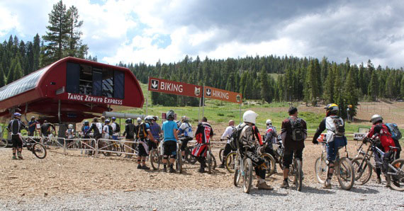
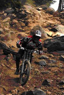
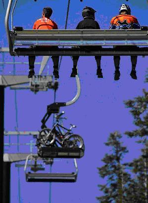
Background The first alpine ski facility was built in 1924 near Tahoe City, California, now called Granlibakken, and also held the 1931 Winter Olympic Trails. Over time, ski resorts with some sort of means of assisting a skier up the hill begin to develop and increase in the Lake Tahoe region. Assisting a skier could be anything from a simple tow-rope with a handle to a modern day six passenger high speed chairlift. When the snow melts the resorts would close for the season in the past. Today, more and more resorts are staying open year around changing activities to suit the season. Empty chairlift? No snow? Bring on mountain biking and hiking using the chair lifts as transportation to the top of the mountain. A few resorts, in the case of Northstar, add a special chair to the chairlift to carry up the mountain bikes and the riders use the regular chair from the snow season to get a lift up. Once at the top its all down hill. There is over 100 miles of biking trails. Northstar's summit elevation is 8610 feet with a vertical drop of 2280 feet. For the extreme riders, Northstar has built jumps, berms, bridges, trails, and other features for some extreme mountain biking. They have also included irrigation systems to keep the dust down. These areas are similar to the parks and pipes used in the winter for snowboarders and skiers, but made out of dirt, and other constuction material. There are also places to ride where it is not so extreme. The mountain is for any level or experience of the rider. Some trails have little elevation rise with no obstacles. A mountain biker may also choose not to use the chairlift by starting out at the lodge and ride uphill following any trail. For high speed thrill of mountain biking, Northstar is the place to go in the Western United States for an extensive lift operation allowing for technical riding on cross country trails. Click here for Northstar's Mountain Biking information. Squaw Valley offers less of a technical trail for the leisure ride as well as a mountain technical bike park. The leisure trail follows along the Truckee River in a safe from traffic environment. For riding mountain trails the cable car, which goes up to High Camp at 8200 feet in elevation, gives a boost up the mountain to access the park and many cross country trails. The mountain also is the most vertical of any other mountain bike park in the Lake Tahoe area. The vertical drop of the mountain is 2850 feet with a summit elevation of 9050 feet. Trails can include boulders and smooth terrain. Squaw Valley has been the venue for the Mountain Bike World Cup. Recently, more trails in the higher country were opened. The ride at this resort is also for all levels of athletes. Click here for Squaw Valley's Mountain Biking information, an article about the re-opening of the bike park . | |
|
Northstar-At-Tahoe Chairlift Line | |
| |
|
Hiking is another activity enjoyed by many. Hikers and sightseers may also ride the chairlift and enjoy the designated hiking trails along with the mountain bikers. Some hikers choose to go beyond the resort and hike to lakes, top of peaks, and connecting to other existing trails. Using the chairlift can extend the distance of the hiker to reach those peaks with views of Lake Tahoe. Guided and interpretive hikes are available too. The wild flowers and views are outstanding at both resorts and can be enjoyed by all. Northstar offers miles of trails right at the resort. The hikers ride the same lift as the mountain bikers. While hiking you can participate in Geocaching, a popular search for hidden caches placed by other people for fun. Another option is ride the chairlift just for the scenic view. Click here for Northstar's hiking information. Squaw Valley hikes, via the cable car, have a starting point at High Camp. Trails go to the top of Squaw Peak at 8900 feet elevation, the high point for Squaw Valley Resort. Granite Chief Wilderness is just behind the resort. Peaks and meadows with different kind of terrains are available for hiking. When a hiker is done for the day and back at High Camp, there is a restaurant and a couple of café’s as well as a large swimming pool with a hot tub. It’s a great place to relax after a long day of hiking enjoying the breathtaking views of Lake Tahoe. Click here for Squaw Valley's hiking information. | |
|
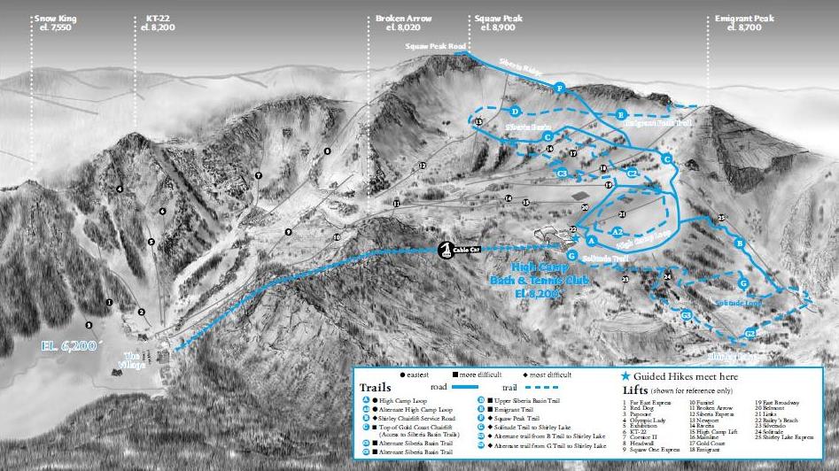
Northstar Mountain Biking Trail Map 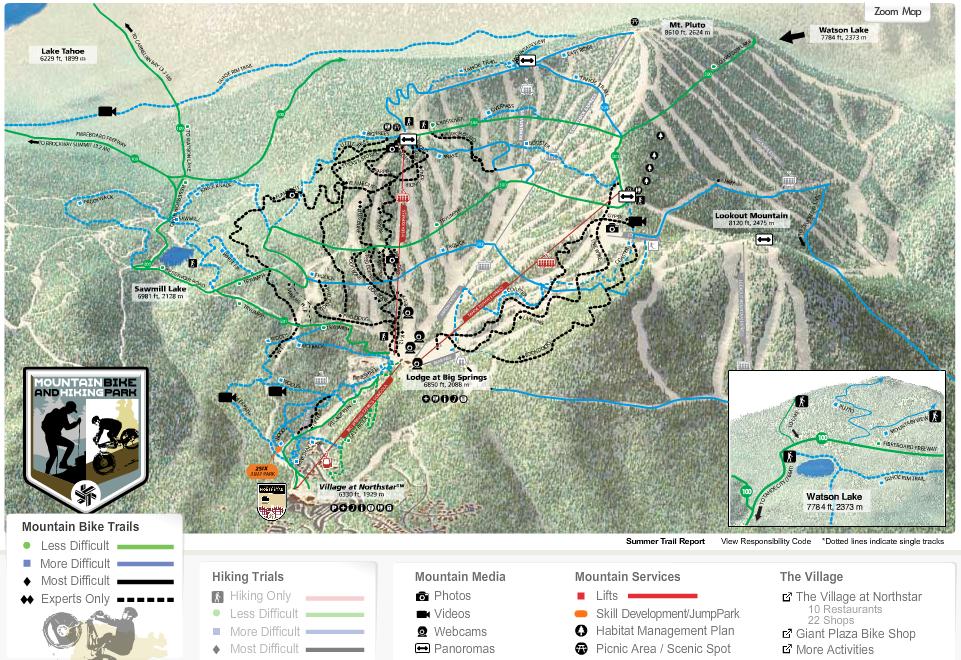
|
Northstar Hiking Trail Map 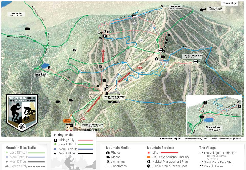 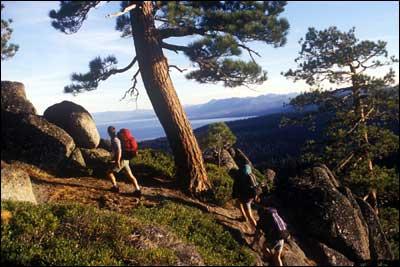
|
|
Methods My goal was to make an interactive map of the Lake Tahoe area including all 14 ski resorts and provide information of each sport, activity, lodging information, and food each resort has available during the summer months. An interested vacationer would be able to see the map with all resorts and location around the Lake Tahoe, click on a site to see the available amenities, and from there link to the resorts web site for more details and arangements. I thought this would help people in their decision of choosing the best place to go for their desired activities of recreation and expose new interests. As it turned out there were lots of things to do. They ranged from passive activities to extreme sports. Some resorts were not even open for the public to use and others welcomed vacationers. Since there was a lot of information to process, the task at hand was turning out to be very time consuming. By narrowing down activities to a couple of subjects would prove to be much more productive for this project. I chose two resorts that operate their ski lifts in the summer to gain elevation for hiking and biking activities, extreme and passive. I began researching articles on web sites that featured mountain biking. Also. I went to the web sites of the ski resorts I have been to where I have participated in such fun. I also had some hiking and trail map books of Lake Tahoe that I researched. They were not to informative for what I was looking for. I acquired more information reading mountain biking articles on the Internet. I wanted to include coordinates for both resorts and acquired them from Google Earth. This way people unfamiliar with the area could go directly to the location on their GPS. I wanted to include a topographic map with the terrain contours, but couldn’t find a decent one available without purchasing it. I thought it would be very helpful to see the elevation change to get a visual idea of the steepness to flat surface. Much to my regret I did not include one. I did include a simple black and white elevation profile I made using Google maps. | |
|
Northstar Elevation Profile 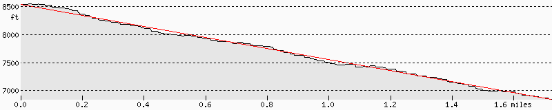
| Squaw Valley Elevation Profile 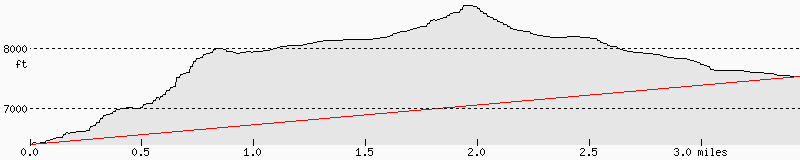
|
|
I was able to acquire trail maps and photos from Northstar-At-Tahoe Resort and photos of various web sites. I had photos of my own from previous trips but didn’t like the quality of them. As far as making the original interactive map, it was quite time consuming and I needed more experience with ArcMap. I will save it for another project down the road. | |
|
Results The results of the project overall gives information to interested parties of mountain biking and hiking activities available in the summer at two ski resorts in North Lake Tahoe. I am not sure how many people realize there are ski resorts operating chairlifts in the summer months of the year. Even if your not hiking or mountain biking, it would be fun just to ride the chairlift to the top and see wildlife, wild flowers, conifer trees, breathtaking views, lakes, and geology. I hope the map would bring attention to more possibilities of fun and excitement while vacationing in the Lake Tahoe area, By creating the map it allows a user to cut down on website searching by eliminating the need to go to every resort to acquire information while planning a vacation or visiting for the day. The elimination process is done on the map. The terrain and mountain features are given showing all its attributes. An available link to the interested resort’s web site is available for more detailed information. | |
|
Squaw Valley Hiking Map |
|
|
Analysis I like the idea of interactive maps. They can be easy to use and very informative. Some of the ones I explored on the Internet left out a lot of valuable information. I think by narrowing down the subjects, more data related to the subject can be included and would be more interesting to the reader. There is a lot of available information on the Internet for gathering data and maps. Also, many books have been written about the different sports available to Lake Tahoe and its famous ski resorts. I didn’t have too much trouble acquiring the necessary details of the chosen resorts. I mostly used the resorts websites for collecting data. The Northstar web site is easy to use and understand. Northstar provided lots of information as a whole being very informative about all their amenities. The Squaw Valley’s web site was good to, but it lacks information about other times of the year. It was difficult to get summer information because they are focusing on winter activities still at the time of this writing, spring. I had to look further to other sources for information. | |
|
Conclusions Lake Tahoe’s recreation activities are numerous. The mountain offers a large variety of fun in many different forms. With a lot of places to visit, a map helps sort through the multitude of activities and adventure helping to narrow down which ones are most interesting. Some people know exactly what sport they want to do and just need to find a place that offers a location for it. Others are just looking for updates on a location they already know of. Northstar and Squaw Valley are excellent places for enjoying hiking and mountain biking. They offer thrilling adventure or a relaxing pace for hiking or mountain biking. GIS is a useful tool in bringing together information and data in the simple form of a map. Using GIS helped to collect the information and present it for any interested party to view and help them in there decision making as to which ski resorts to visit. | |
|
References Northstar-at-Tahoe™, 5001 Northstar Drive Truckee, CA, http://www.northstarattahoe.com Squaw Valley USA, 1960 Squaw Valley Rd., Olympic Valley, CA , http://www.squaw.com Richmond, A. (2010) artical, CA , http://www.squaw.com Singletracks, Bike The Net articals, (2010-2011) Blue Spruce Ventures, GA http://www.singletracks.com/ White, M. (2004). Lake Tahoe, Must-Do Hikes For Everyone. California: Wilderness Press blog-flowers2.bmp, unknown Author, Lake Tahoe Getaways, Pinnacle Real Estate Group - Lake Tahoe, http://www.laketahoegetaways.com TahoeRimReststoppng, National Recreation Trails, American Trails, Redding, CA, http://www.americantrails.org/about.html Resort Map, tahoereservations.com,LLC, http://www.tahoereservations.com/about.html Flagg, K.,fact/gif, Boulevards, City Guides, http://www.laketahoe.org/ | |