| Aquisition of Spatial Data to Locate and Design a Disc Golf Course | |
|
Author Walker Wieland American River College, Geography 350: Data Acquisition in GIS; Spring 2011 Contact Information: heatstone81@hotmail.com | |
|
Abstract This is the summary of the entire paper. All the following sections should be represented by a single sentence or two, with the exception of background and references. Write this last. | |
|
Introduction Municipalities often award money to individuals that can design ways to improve the benefit of public land use, through verified planning techniques and competent concepts. If a parcel of land that is publicly owned for the use of recreation, local governments want to encourage people to come to these places to enjoy themselves along with a change of scenery. Some ways to encourage individuals to come to recreation areas, especially newly established recreation areas, are by advertising a special feature of mode of recreation that might attract certain clientele. I am going to combine one of my favorite outdoor activities with data acquisition techniques in GIS in order to design a recreational benefit that could potentially earn a recognition, a monetary award to implement the facility, and to achieve the eventual goal of attracting others to this recreational area for beneficial land use. Disc golf is a fringe sport that has gained in popularity over the past 10 years. The concepts are simple: use frisbees, instead of golf balls, to throw in a basket, instead of a hole. Many of the traditional golf concepts apply: you aim to get the lowest score possible, and there are many different frisbees (discs) and many different techniques to get the disc to the basket. Disc golf is increasing in popularity because it is generally free to play (except for parking), and the technology of disc manufacturing is increasing to allow for increased versatility of discs when used during the game. I have enjoyed disc golf for about 18 months, and I find it will be a game I will enjoy for a long time. A passion I have had since before ever playing disc golf was to design a golf course, because I loved to be outside and to organize games spatially. Now that I play disc golf more regularly than ball golf, my goal is to design a disc golf course in an available California public park using my newly acquired skills in GIS. During this project, I will gather multiple types of basemap data (including aerials, park data, census data, DEMs, and other datasets) in order to decide where the most suitable locations to build a disc golf course will be. Then, I will perform multiple geoprocessing tasks to determine which parks will be suitable to attract disc golfers. Once I find the course of choice (presumably in Northern California), I will go to this park to not only verify my off-site study, but also to collect GPS points to design tees and baskets for a 9 to 18 hole course, and then project this data into arcmap to draw out a map of my disc golf course. If I find that my results are successful, I will submit my plans to the county of which the park is placed. | |
|
Background I searched for literature on designing disc golf courses through GIS but could not find any. However, I did not do a literature search on designing parks through GIS. I did not think many of the principles of designing a park would necessarily apply to my disc golf project, since I am putting a course inside of an already existing course. | |
|
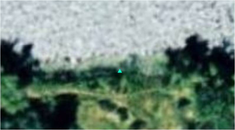
Methods I collected data from SACOG on multiple attributes that would potentially be useful for gaining when researching the right type of environment for a disc golf course. I looked for parks that were larger than 80 acres, and those that had over 60 units of space that could be used for open space. I looked at density of schools and decided there needed to be at least three schools, college or K-12 within 3 miles of the course. I like encorporating water bodies into disc golf, so I looked for courses that were near bodies of water like lakes and creeks. I wanted them to be in Sacramento or Placer County, and I wanted them to have a parking lot. I knew that nature preserves could not have any type of building on them, so I excluded nature preserves from the criteria. After my analysis by selecting out certain parks with these attributes, I was left with 6 parks: 4 in Sacramento County, and 2 in Placer County. 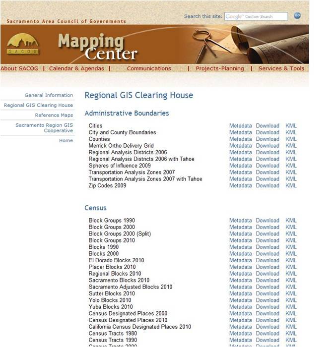 I picked one at random, and it was listed as Mather Field Regional Park. The park is quite massive so it took some time to look around it and see what areas had the potential of being developed. I found that Mather Lake was a cool area with some open space around it so I chose it as a candidate for my course. I used an application on my phone called Theodolite, which takes the coordinates of your location at the same time you take a picture, essentially geocoding your picture. The application also records some other data onscreen. I thought that this application would be perfect for my project, because I could take pictures of my potential tee boxes and holes and at the same time, geocode them for a GIS. I did some ground truthing out at Mather Park to make sure the areas I selected for tee boxes and holes were in open space areas, and were not too close to places where other people would be. 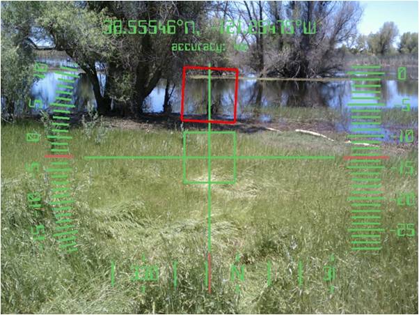 I collected all my GPS points through Theodolite and then took the data back to the lab. I thought that there might be an easy way to take the XY data directly from the picture and put it into a database, but I could not find a way to find the XY data. So, the alternative for me was to write down the XY coordinates that had been displayed in every picture, and then transcribe that data into a table in excel. From here, I exported the data table into a geodatabase I had created in ArcMap, then I chose the option to 'display XY data', which essentially transforms the XY data into a feature layer on the map. After some troubleshooting, which included projecting the data in WGS 1984 (although my shapefile data was in Cal State Plane II), The data displayed properly on the map. 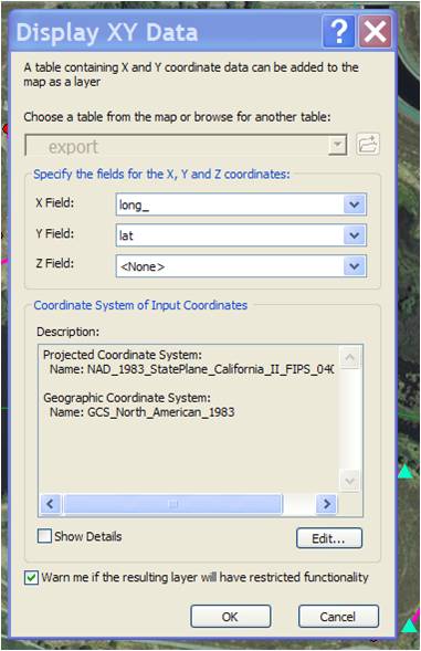 |
|
|
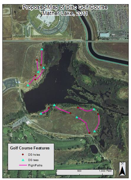
Results The XY data was displayed in ArcMap, and now I had point features that represented
disc golf tees and holes around Mather Lake. My results contain a created map that could potentially be presented to a county
group for open space or Parks and Rec that shows the viability of installing a disc golf course around Mather Lake.
 | |
|
Analysis Data quality was the last important component of this project. One of the main things
I wanted to evaluate was the data quality of my GPS data collection. I knew that since I was not using a good GPS unit, I would
likely get poor data accuracy. The best accuracy that the Theodolite unit could get was at 3 meters. However, I knew that this poor
level of accuracy would not affect my map and data points too much, because my map was of a larger area and that the picture of the
hole and tee box might be able to make up for the poor accuracy, for example, the coordinates could lead the construction person
to the right place, and then the picture might provide further guidance on where to build the tee and box. I had difficultiy with
entering my XY coordinates into ArcMap for some time, until I realized that I was trying to add degrees, minutes and seconds to a
State Plane Zone, and the result was a point feature class that ended up in space. Once I projected the point data as WGS 1984 and not
State Plane, the coordinates landed in the right place. One instance was a good example of poor data accuracy: a hole was supposed to be
3 feet from the lakes edge, and ArcMap put it in the water. In this case, I would hope that the picture would provide insight on where
to install the hole.
 | |
|
Conclusions In conclusion, I would say that my project was moderately successfull. I think that the
selection process was good, but I would have liked to evaluate more geospatial features, such as existing disc golf courses. I would have
liked a little bit more accuracy on the GPS points. However, besides that, I feel that I found an area that could accomodate a 9 hole disc
golf course, and I designed it in a way where people could access it, get excersize, and stay far away from those who fish at the lake so
that both groups can enjoy the land simeltaneously. | |
|
References SACOG regional GIS clearninghouse http://www.sacog.org/mapping/clearinghouse/ | |