A Study of the Region's Local Farming Community
Sean McCartney
Geography 350 - Data Acquisition in GIS
Fall 2011
Farmers' markets are one of the oldest forms of direct marketing by small farmers. From the traditional "mercados" in the Peruvian Andes to the unique street markets in Asia, growers all over the world gather weekly to sell their produce directly to the public. In the last decade they have become a favorite marketing method for many farmers throughout the United States, and a weekly ritual for many shoppers. With the growth of farmer's markets throughout the country, people are rediscovering the benefits of supporting local producers. It is in this vain I chose to undertake a project to collect and organize spatial information pertaining to Sacramento's certified farmers' markets.
My methodology was to first collect data for an intended GIS by undertaking surveys at the three largest year-round certified farmers' markets. After acquiring this data I created a GIS with datasets downloaded from the US census bureau and from my research. Upon completing my map documents, I performed statistical analysis with ArcMaps geoprocessing services. My results led to greater insights into Sacramento's farming community, and the city's certified farmers' markets.
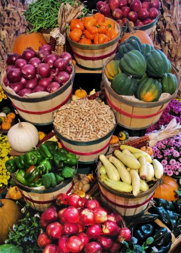
Certified Farmers' Markets are an effort to reestablish the traditional link between farmers and consumers in California. By eliminating the middleman's additional costs and multiple product handling, both the farmers and the consumers benefit. (CFMSC, 2009) Farmers can bring field and tree ripened fruits and vegetables to local markets which are too delicate for the packing and shipping processes of traditional food distribution systems. In addition, consumers are assured of obtaining only California grown fruits and vegetables, fresh and in season, at attractive prices. Certified Farmers' Markets have become social gathering places and are the face of the communities they serve. They are where the agrarian community and the urban community relate to each other.
This paper was conceived out of personal interest, and focuses on the desire to create a GIS for
certified farms selling at local farmers’ markets in Sacramento County.
There are numerous websites hosting general information pertaining to farmers’ markets in the area,
but none offering concrete data about the farms, their locations, and their products.
Having reviewed the literature and having consulted with the local managers running the region’s
certified farmers’ markets, it was found entirely lacking any spatial data—and subsequent attribute
data—of the region’s farming community. Without a GIS represent any data pertaining to Sacramento’s
certified farmers’ markets, it makes it very difficult to view, query, and share this information with
others—and to analyze ancillary data for greater understanding.
My project was completed in three phases:
The first objective was to acquire the raw data needed to create a GIS of all certified farms selling
at the three largest year-round farmers’ markets in Sacramento.
The second objective was to compile all the data into a GIS to view it spatially and perform analysis.
The third objective was to have a working GIS to share with local farming associations to improve and update their services.
The acquiring of my data on seasonal farms selling at Sacramento farmers' markets--and the means to display this data-- took time as well as appropriate software and hardware. Area markets are dynamic in the sense even though they are open year-round, not all farms grow throughout the seasons, making data acquisition an iterative process. One must collect data seasonally, so the data collected for this report is only relevant to autumn sellers at area markets in Fall of 2011. The two associations promoting local farmers' markets are the CA Federation of Certified Farmers’ Markets, and Certified Farmers’ Markets of Sacramento County. I consulted the latter before undertaking my project to see if I could leverage any prior data before undertaking my research.
The workflow for my project was to first head to the three largest, certified year-round markets in Sacramento County. I interviewed the vendors selling there, collecting information on each farm name, location, total months selling at area markets (year-round vs. seasonal), and if they market their produce in ways outside of traditional means (internet, restaurants, wholsesalers, etc.). I also took GPS waypoints for all three farmers' markets I conducted my reseach on.
Once my data was acquired, I sought the means to convey my data spatially. This part of the workflow involved acquiring TIGER files from the US census. I was able to format TIGER shapefiles to contain the attribute data from my data collected at the three farmers' markets. This part of the project took time to query specific information pertaining to shapefiles, join the data, merge shapefiles together, repeat the process for each farmers' market location, and present the maps in a way that are quantitatively and qualitatively accurate.
There are numerous books and websites pertaining to local agriculture and farmers' markets, and the primary sources I used to obtain this information were the American River College library, and the internet. It was almost overwhelming sorting through the references available to me, so I chose a sample of literature most appropriate to my research, and left the rest for future discoveries.
My interest in the local food movement stems from the imbalances I see in global food production. Access to markets for small farms is desperately needed to keep them viable in the long-term. The growth of local farmers' markets has provided outlets for small farms, and given consumers an alternative to packaged, long-distance commodities that we have grown so acsustomed to. Through my research I concluded there is insufficient data to share with local groups and associations promoting Sacramento farmers' markets. For interested parties, one would have to frequent every local farmers' market in the area before knowing where our local providers are for seasonal fruits, vegetables, beef, chicken, fish, eggs, cheese, etc. With this problem out the outset, I created a workflow from which to gain pertinent information relating to area farms, develop a working GIS to organize and analzye the data, and from there have a means to easily share this information--both spatially and tabular--to local associations working to promote the local farming community.
The first step to securing my data was to decide upon a reasonable sample of farmers' markets from which to base my research. I concluded the representative samples would have to be year-round markets, they would have to be certified California farmers' markets, and they would have to be markets with a large number of vendors. I settled on the Thursday market at Florin Mall, the Saturday market at Country Club Mall, and the Sunday market under the I-80 freeway downtown. All three markets met this criteria. From there I proceeded to the markets themselves, interviewing each vendor during the first-half of November to gain where they are from, what is currently in season, if they sell year-round at the market, and what other means they use to market their products. With this information I was able to return home and start compiling the raw data into my GIS. All interviews conducted were done with a simple spiral notebook and pen.
To build my GIS, I went to the US census to acquire TIGER files. I downloaded county, state and country shapefiles, and from them I queried attribute data to have shapefiles I could use for my project. With a base map and ouputted shapefiles, I brought my raw data into newly created fields, and made four separate maps representing my data. The first was a map of all farms selling to the farmers' markets where I conducted my surveys, the remaining three maps were specific to the farms selling at each respective market in Florin, Country Club, and Downtown. With my GIS ready, I performed simple queires and geoprocessing tasks to learn where certain goods are originating, and the proximities from the farms to their markets in the state capitol.
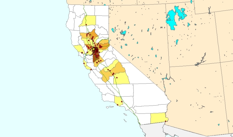
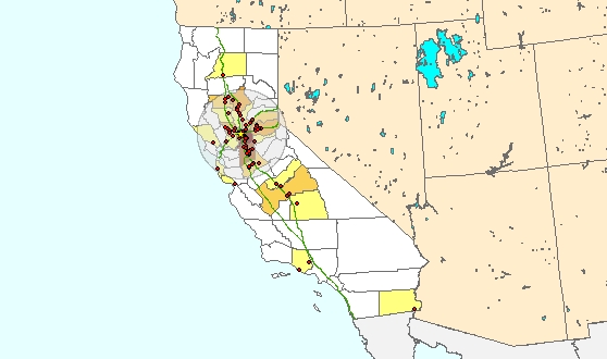
I was able to acquire all data for my project and correlate them spatially with TIGER files from the US Census, though for a more accurate depiction of farm locations, I would have had to go to each individual farm to GPS their location and plug this data into ArcGIS for greater accuracy. As it stands, I used TIGER files to represent the nearest possible location of the farms without having to go and ground-truth them myself. This would have taken too much time and been impractical for the project. It was not until I was able to load the data into shapefiles and view them in an ArcMap document that I was able to start to draw correlations in varieties of food, where they are being grown, and how far they are being shipped from farm to Sacramento farmers' market. There is a "locavore" movement that holds the philosophy one should try their best to only purchase food from within a 100-mile radius from one's home. For greater understanding, I used the buffer tool to set a 100-mile buffer around Sacramento, so I could easily see what farms fall within this distance. I also used some other geoprocessing tools for greater analysis to find the sum of farms selling at Sacramento markets on a county basis. Both of these reults are given below. I also used several other geoprocessing tasks through ArcMap to select specific products to see where they originate.
As repeated earlier in my report, for a total understanding of certified farms selling to the region's farmers' markets, one would have to conduct surveys on a seasonal basis, as not all farms produce nor participate in farmers' markets year-round.
A result that should please the "locavore" community is in fact, the majority of farms selling at certified Sacramento farmers' markets are indeed within a 100-mile radius, and a great diversity of products are available year-round to local consumers. Farmers who sell direct to the public without going through a middle man get a better price for their goods, and more capital stays in the local economy for other goods and services. I hope to share this information with my contacts in the association, Certified Farmers’ Markets of Sacramento County, so they can analyze the data and draw insights of their own.
| County | # Of Farms Selling at Sacramento Farmers' Markets |
| Sacramento | 16 |
| San Joaquin | 13 |
| Yolo | 9 |
| El Dorado | 7 |
| Butte | 6 |
| Stanislaus | 5 |
| Fresno | 4 |
| Placer | 3 |
| Glenn | 3 |
| Sutter | 2 |
| Solano | 2 |
| Ventura | 2 |
| Sonoma | 2 |
| Colusa | 1 |
| Yuba | 1 |
| Shasta | 1 |
| Imperial | 1 |
| San Mateo | 1 |
| Santa Cruz | 1 |
| Amador | 1 |
| Tulare | 1 |
| Madera | 1 |
I was pleased with the result of my project for GEOG 350 because I was able to create the first GIS that I know of for farms selling at Sacramento farmers' markets. Acquiring the data for my data sets was both time consuming and required much patience. Hours were spent at each farmers' market surveyed acquiring my data. But as the old adage goes: "for every job that must be done, find that element of fun." Merging the separate shapefiles representing individual farms into one shapefile allowed me to view a nominal map showing the spatial distribution of farms. It was not until I ran some statistical algorithms that I was able to determine the number of farms by county selling at local markets. My hypothesis from the outset was that the majority of farms selling at local markets would come from adjacent counties, and my results confirmed this. Sacramento and San Joaquin Counties were home to the most number of farms, followed by Yolo and El Dorado Counties respectively (see above chart for the complete breakdown). To discover if our farming community met the requirements of the "locavore" subset of the population (those sourcing their food from within 100 miles of their home), I placed a 100-mile buffer around the city of Sacramento. By far the majority of certified farms selling at Sacramento farmers' markets fell within this proximity.
Faced with global insecurities over food and climate change, and the rising costs of fossil fuels to both produce and deliver food commodities to consumers, it is comforting to see how our local farming community is meeting these challenges. The demand has never been higher for sourcing fresh food, grown locally, direct from farm to table. The geography of the central valley of California permits year-round cultivation, endowing the state with an agrarian potential that would leave Thomas Jefferson in envy. Having started this project with vague notions of where our food is grown, and desiring to answer these fundamental questions, I am pleased with my results. Certified Farmers' Markets are an effort to reestablish the traditional link between farmers and consumers in California. By eliminating the middleman's additional costs and multiple product handling, both the farmers and the consumers benefit. Lower costs, a diminished carbon footprint, and job security for local farms--this is what access to farmers' markets means for both grower and consumer.
Like the persimmon tree giving fruit in season and then resting over winter, agriculture is a dynamic industry, and my results are but a snapshot of where and how crops are delivered to market during one month of the year. To follow up on this project for greater insight and understanding, one would need to go to the same markets I conducted my surveys on to document the changes over the year. Only then will the GIS practitioner have appropriate data to run analysis, as well as a comprehensive understanding of the seasonal changes affecting farmers' markets. Fortunately for me, my intention is just that.....
American Farmland Trust http://www.farmland.org/
Astyk, Sharon, Aaron Newton. "A Nation of Farmers." New Society Publishers, March 2009
CA Federation of Certified Farmers’ Markets http://www.cafarmersmarkets.com/
Certified Farmers’ Markets of Sacramento County http://www.california-grown.com/cfm-about-us.html
Francis, Amy. "The Local Food Movement." Greenhaven Press, 2010
USDA http://www.ams.usda.gov/AMSv1.0/farmersmarkets
USDA http://www.ams.usda.gov/AMSv1.0/getfile?dDocName=STELPRDC5080175&acct=frmrdirmkt
Westhoff, Patrick. "The Economics of Food." How Feeding and Fueling the Planet Affects Food Prices.
Pearson Education, Inc. 2010