Title
Locating My Ideal Public Park in North Natomas
Author Information
Hung Nguyen
American River College, Geography 350: Data Acquisition in GIS; Fall 2011
nguyenh90@imail.losrios.edu
Abstract
Living in a residential community where many parks reside, there can be some difficulty in selecting a park. With the aid of GIS, a spatial and attribute query was done to select a public park that met the desired distance, size and the required amount of facilities and amenities. Other forms of conditions could have been added and be applied with the use of GIS.
Introduction
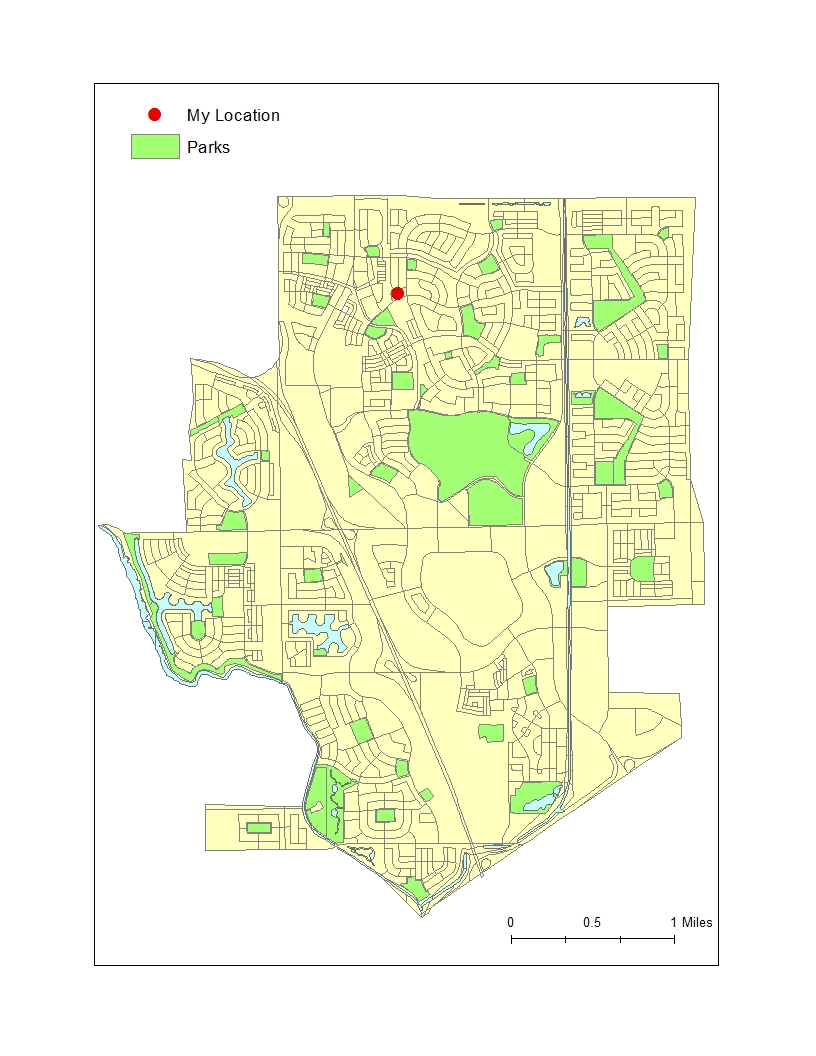
North Natomas is home to multiple public parks. What makes it interesting is how each park is within three miles or less apart from each other. As a resident, finding a park that meets my needs can be troubling. But by using GIS, I can limit my choices and find the park that is right for me.
Background
Parks are a wonderful addition to any neighborhood. They provide an area for recreational use, relaxing, socializing and to simply enjoy the landscape. There are many conditions that can be the deciding factor in selecting a particular park. The Department of Recreation, Park and Tourism Sciences at Texas A&M University, states that, ideally people should be within a quarter-mile distance from any park due to the ease of accessibility and walkability. Size is another factor, which can highlight the overall appeal of a park. Based on a research study on open public space and physical activity, people are most likely to walk through a park if it is recognized as large. Lastly, facilities and amenities are important elements in creating a more attractive and comfortable surrounding for people to enjoy. According to the University of Idaho's Community Design and Research, there are four requirements in creating a successful public place, which are accessibility, activities, social place and comfort.
Methods
Following the criteria listed above, I will create my own guidelines in selecting a park. Also, with the use of GIS, I can narrow down my search from a list of parks. There are three aspects and conditions that my park must fulfill, which are:
Proximity - Distance to my location is important, however, 1/4 of a mile may seem a little low and it will definitely lower my options for parks. Therefore, I am increasing the maximum distance to 1 mile that I am willing to travel.
Size - I do not want a park that is too large. So, I will be looking for one that is about moderate in size from the list of possible parks I am observing.
Features and Amenities - My selected park must have one of each of the following: a basketball court, soccer area, drinking fountains, waste bins, picnic tables and a playground. Lamp posts and benches are the main amenities I am looking for in a park. Furthermore, the more the amenities and features there are in a park the better.
For my data collection, I went to each park that was within my vicinity and did an inventory count based on the features and amenities. I also gathered my shapefiles from the City of Sacramento's Department of Parks and Recreation website.
Results
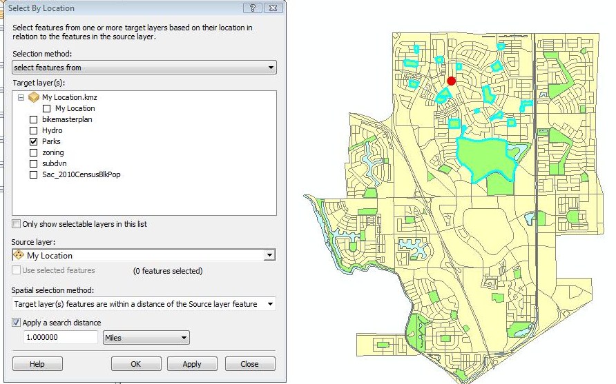
Using the Select by Location tool and setting a 1 mile distance, I can highlight the parks that are within my location.
16 parks out of the 47 have been selected.
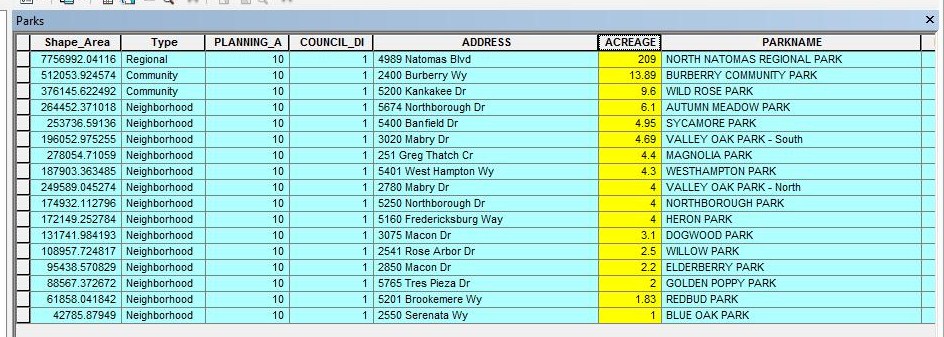
Opening the attribute table of the selected parks gave me an overview of the size of each park in acres. I decided to keep parks that ranged around 4 acres because 3 acres seemed small and anything above 6 acres would be a tad too big.
This leaves me with 5 parks selected. (Note: Valley Oak Park is split into two features and is counted as one park)
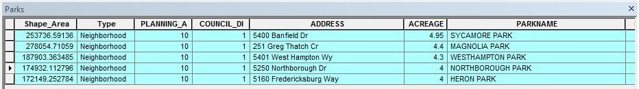
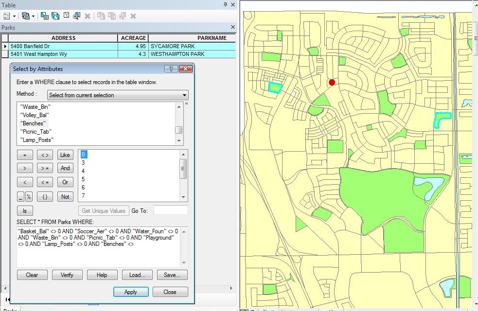
The parks selected must have a basketball court, basketball court, soccer area, drinking fountains, waste bins, picnic tables and a playground. So, I used the Select by Attribute tool and entered a logical expression with the aforementioned variables.
Now only 2 parks are selected.
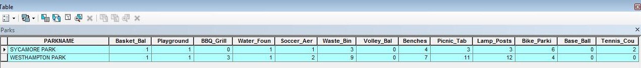
Comparing the parks side by side, I decided to go with Westhampton Park because it is much closer to me and also has much more facilities and amenities than Sycamore Park.
Analysis
Out of the 16 parks that were within my distance, 2 had all the required qualities I wanted. A condition that I wanted to include was restrooms; however, all the parks I went to had no restrooms at all. Also, there were some parks in my area that were incomplete or in the early development stages; these parks would have an impact on my selection and in my results if they were finished.
Conclusion
My main objective was to find a park that had what I wanted. There could have been other factors that I could have added, such as crime rates near parks. This would have added another dimension to my project because safety has become an important issue. However, distance and the amount of features were my main concern. Overall, the use of GIS definitely helped in finding and determining my desired park.
References
City of Sacramento's Department of Parks and Recreation Website: http://www.cityofsacramento.org/parksandrecreation/parks/
Robert J. Donovan, et al. "Increasing Walking: How Important Is Distance To, Attractiveness, And Size Of Public Open Space?." American Journal Of Preventive Medicine 28.(2005): 169-176. Academic Search Premier. Web. 13 Nov. 2011.
Talen, Emily. The Spatial Logic of Parks. Journal of Urban Design 15.4 (2010): 473-491. Academic Search Premier. Web. 14 Nov. 2011.
Texas A&M Department of Parks and Tourism Sciences Website:
http://www.urban-nature.org/publications/documents/UrbanParks.pdf
University of Idaho Community Design and Planning Research Page:
http://www.class.uidaho.edu/communityresearch/park_design.htm