California Historical Landmarks, Sacramento County
Katherine Spiess
spiess.kate@gmail.com
American River College, Geography 350: Data Acquisition in GIS; Fall 2011

#614: Stanford-Lathrop Home (aka Stanford Mansion) #872 California's Capitol Complex, in December #823: Governor's Mansion State Historic Park
Abstract
This project is a compilation of data, both spatial and non-spatial, involving the California Historical Landmarks in Sacramento County.
Introduction
One of the goals of the California State Parks, more specifically the Office of Historic Preservation, is to preserve buildings, structures, sites and places of historic importance as landmarks in California. Part of the intent of preserving these landmarks is for people to visit them and learn about their contribution to shaping modern day society. Spread throughout all of California's 58 counties, they range from a grist mill to an entire city site. For those interested in these historical places it can be a rather tedious job to plan a trip to see more than one at a time as each is listed with only a brief descriptive location or street address and no map view.
To plan a route to see all landmarks within 10 miles of the state capitol, for example, one would have to manually place each of Sacramento County's 57 landmarks on a map after doing necessary research if no specific address is provided, ruling out any known off-hand to be too far away and then draw a route to each which falls in the designated area.
To make it easier for those of us interested in historical places to visit, it is my goal to create a central database in which to compile all relevant data on each landmark as well the location referenced on a map for Sacramento County.
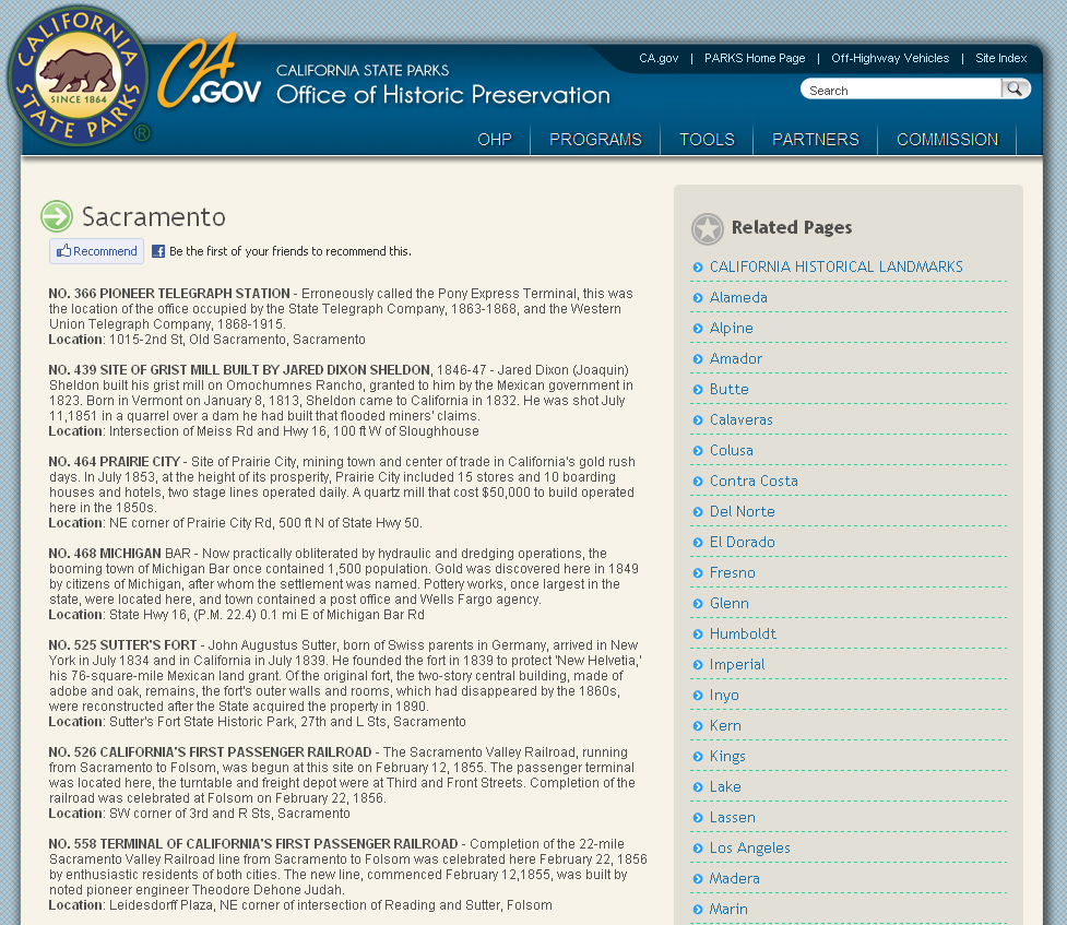
OHP's list of Historical Landmarks for Sacramento County
Source: ohp.parks.ca.gov
Background
The Office of Historic Preservation (OHP), a division of California State Parks, has a list online of all registered state historical landmarks which contains a name, register number, brief description, and approximate location (including city & county). While this proves to be a good starting point, it can be tedious to look up multiple landmarks or pull any geographic data. There are also websites such as Waymarking.com and The Historical Marker Database, but neither is comprehensive and since they rely on user information, the data is not always correct. For some of the landmarks, especially for buildings, The Library of Congress website can provide excellent historical background, including old photographs and drawings, but little to no geographic data is provided.
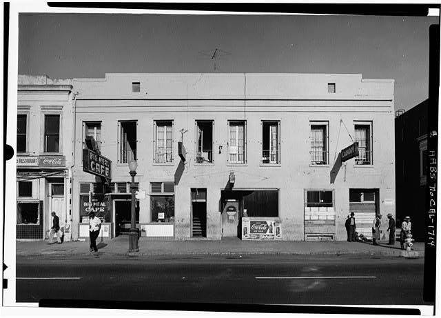
Original Sacramento Bee building as seen in 1964 prior to demolition for the construction of I-5
Source: Library of Congress
Methods
Starting with the Office of Historic Preservation’s list of historical landmarks in Sacramento County, I started compiling data in an Excel spreadsheet. Data collected includes register number, name, description, location, latitude, longitude, date registered, plaque inscription, location group, and notes. This spreadsheet can be sorted by any category A-Z or numerically as desired. Information was gathered both firsthand by visiting a select group of sites, as well as information gathered from online sources including Waymarking.com, The Historical Marker Database, Google Maps, Google Earth, and The Library of Congress. Once each landmark had all relevant available information filled in on the spreadsheet, they were added as points in Google Earth and given their name designated by OHP, The register number, plaque inscription, and/or OHP’s description of the site was also included in the properties description field. These points were then exported as a .kmz file and converted to a shapefile for ArcMap using scripts found online. Then, using the join function, the excel spreadsheet with all other information was added to the attribute table for the point data.
Results
The results of collecting all of this data is a Google Earth file that one can use to plan trips to visit landmark sites as well as an ArcMap document that one can perform spatial search functions and look up attribute data. See Appendix for files.
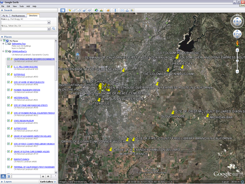
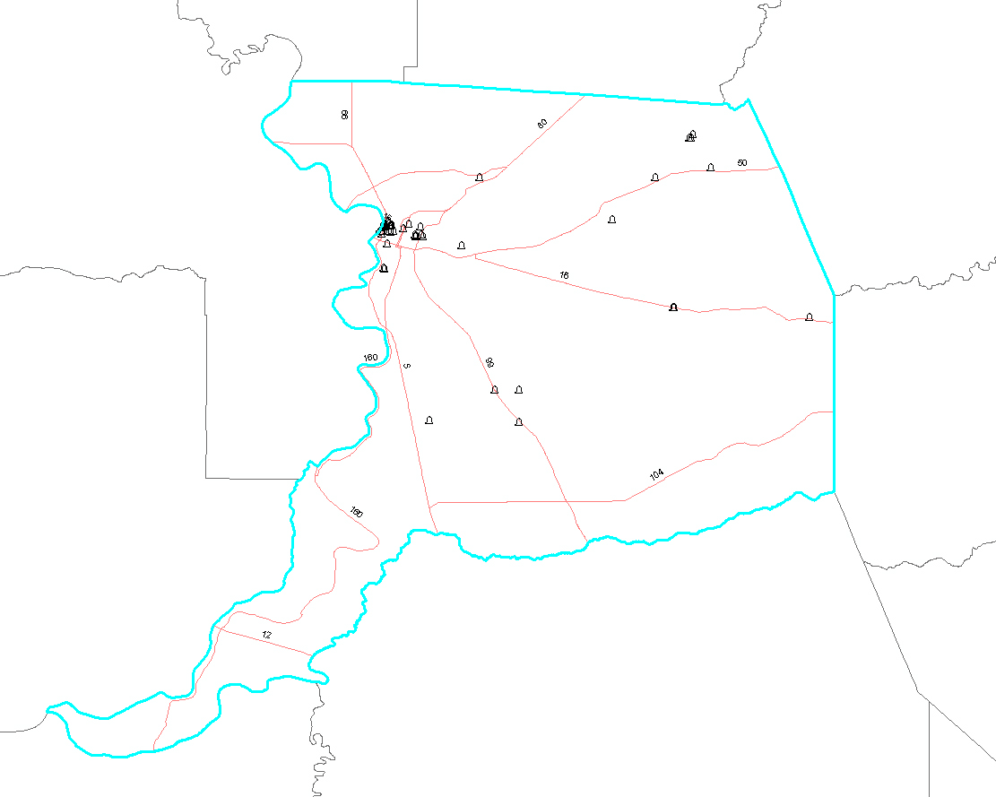
Screenshot of all points located in Google Earth for Sacramento County
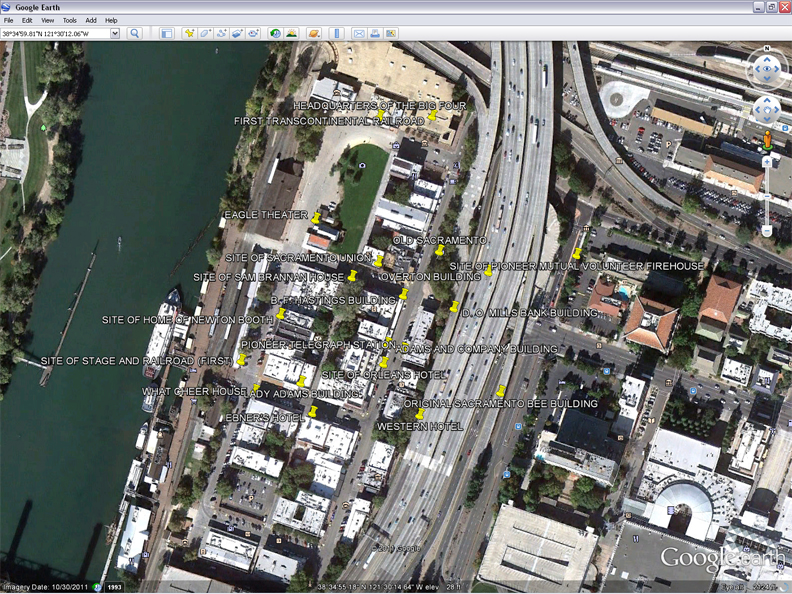
View of landmarks located in Old Sacramento in Google Earth
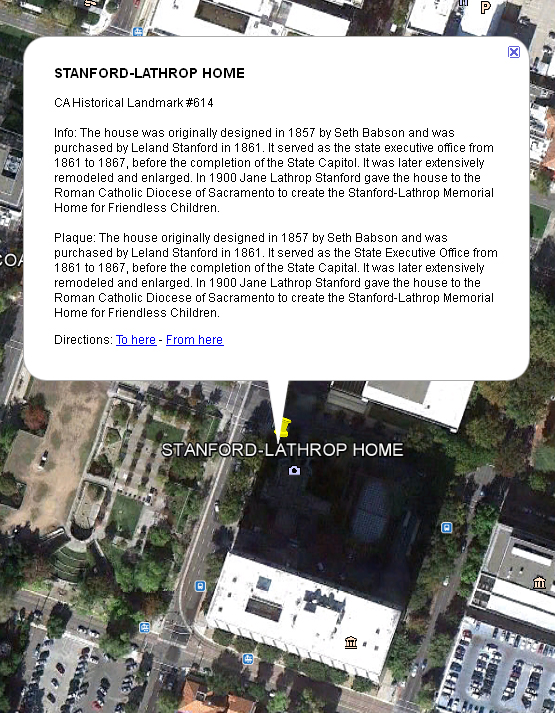
Details on the Stanford Mansion, aka the Stnford-Lathrop Home in Google Earth
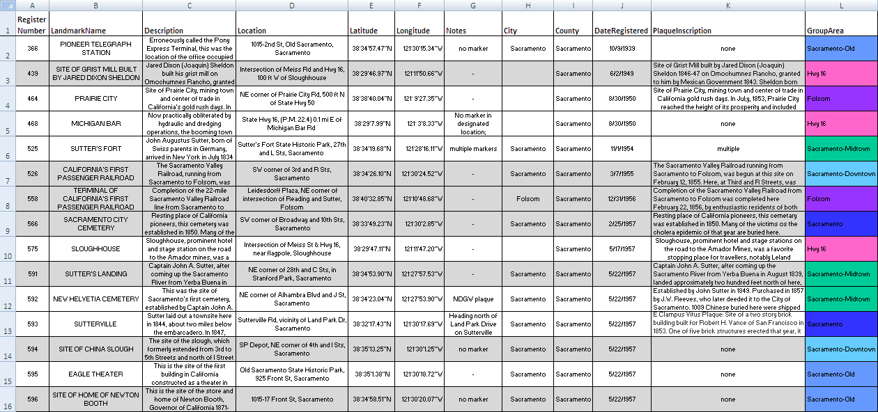
Excel spreadsheet used to enter in all data for each landmark
Landmarks from Google Earth's .kml file converted to .shp (shapefile) in ArcMap
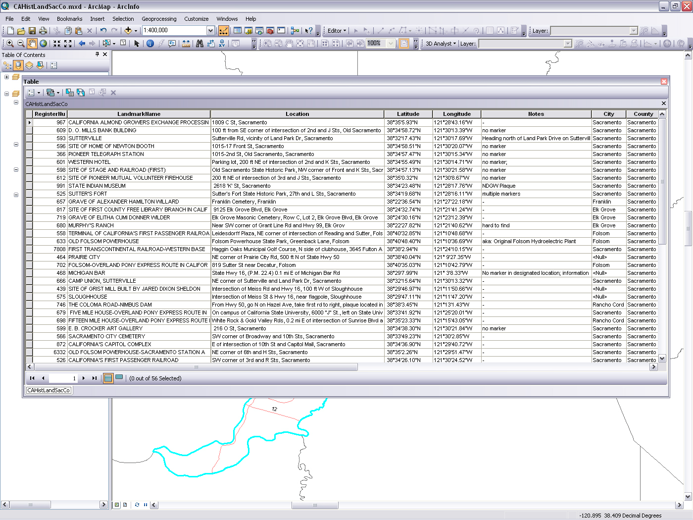
Attribute table with data imported from Excel
Analysis
When I first started this project, I was planning on visiting each landmark site and taking coordinates and a photo. But after a few only partially successful initial trips, it turned out to be much easier to consult the various online sources for locational and informational data. Some landmarks do not have marker plaques, and others no longer physically exist. Some have both problems. Another problem was that Sacramento County covers a fairly large area, and most of the landmarks not within Midtown & Downtown Sacramento were spread out considerably. Even when the landmarks are close together, it can take a long time to get through a short list as sometimes they’re easy to miss without exact coordinates. Number 654, the site of the “First Jewish Synagogue Owned by a Congregation on the West Coast” was a good example as it’s in the sidewalk under a tree. One of the online sources had only located the sign saying it was nearby, and not the actual landmark itself. Luckily it was easy to find on foot if you knew what to look for.

#654: Site of the First Jewish Synagogue Owned by a Congregation on the West Coast
Conclusion
After all the data was gathered, I feel much more confident in someone being able to take the information from the .kml file in tandem with the excel spreadsheet and be able to locate any of the landmarks (with the exception of the Nisipowian Villiage Site, #900 as it's location is protected under state law). Hopefully having this data avaliable will encourage others to explor the rich history of the Sacramento area.

#657 Grave of Alexander Hamilton Willard, last survivor of the Lewis & Clark expedition
References
Google Earth. 10 Dec. 2011. http://www.google.com/earth/index.html
Historical Marker Database. Web. 4 Dec. 2011. http://www.hmdb.org/
Library of Congress Web. 4 Dec. 2011. http://www.loc.gov/index.html
McMannis, Sam. "Sacramento sites on Historic Register sometimes elusive". The Sacramento Bee. 5 Nov. 2011. http://www.sacbee.com/
Office of Historic Preservation. Web. 4 Dec. 2011. http://ohp.parks.ca.gov.
Office of Historic Preservation, California Department of Parks and Recreation. California Historical Landmarks. 1990. Print.
The Thomas Guide, Sacramento County Street Guide. 40th ed. Rand McNally. 2009. Print
Waymarking.com. Groundspeak, Inc. Web. 4 Dec. 2011. http://www.waymarking.com/
Appendix
Excel Spreadsheet for Sac County Historical Landmarks
.kml file for use with Google Earth or Expert GPS
Shapefile zip for ArcMap
PDF of Sac County Historic Landmarks from ArcMap