GPS RELATIVE POSITIONING DESIGN PROJECT
GEOGRAPHY 350 DATA ACQUISITION
AMERICAN RIVER COLLEGE
NICK LABEDZKI
SPRING 2012
PROJECT REPORT
The purpose of this project was to fulfill the class requirement for Geography 350, Data Acquisition at American River College. The project entailed the design, vector processing, inner constrained adjustments, constrained adjustments and presentation of coordinates using GPS surveying methods. This project is also to serve as an instructional guide for my professional surveying work at California State Parks, where I am employed as a Transportation Surveyor.
On December 3, 2010 I conducted a GPS survey utilizing the Standards and Guidelines for Cadastral Surveys Using Global Positioning System Methods (May 9, 2001, Version 1) by the United States Department of Agriculture-Forest Service and United States Department of the Interior-Bureau of Land Management and Geospatial Positioning Accuracy Standards (refer to the References section).
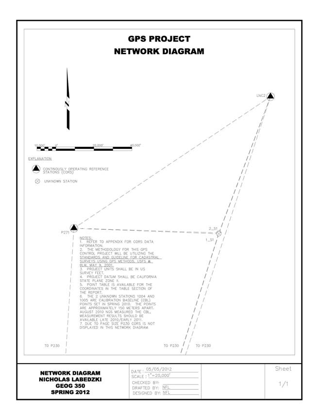
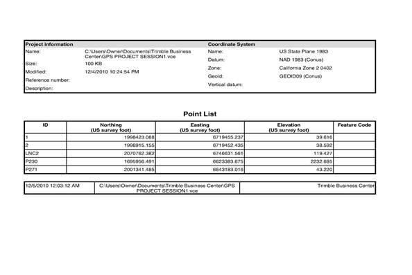
The GPS Project consisted of 2 sessions using Trimble GPS units. The first session was approximately one hour and the second session was approximately thirty minutes. The Trimble GPS units were 4800(L1/L2). Three Continuous Operating Reference Stations(CORS) were utilized for this project. The Stations were LNC2, P230 and P271. The Permanent Identifier (PID) National Geodetic Survey (NGS) sheets are available in the Appendix. Trimble Business Center (TBC) version 2.3 was used to process the GPS data.
The newly constructed Calibration Base Line (CBL) in Sacramento was used as the study area for this project. The 0 meter monument and the 150 meter monument were the unknown points. Originally the 0 meter and the 1000 meter monuments were going to be used for this project, but due to security reasons the 150 meter monuments were chosen. Prior to starting the survey the tribrach and the prism pole was checked. The height of instruments were collected and recorded in a field notebook in both meters and US Survey Feet. The start and end times were also noted in the field book. A scan of the field notes are available in the Appendix.
PROJECT PROCEDURES
The data from both GPS receivers were downloaded using the Trimble Data Transfer program. A total of 8 files were downloaded. The files were called: 94683370.DAT, 94683370.EPH, 94683380.DAT, 94683380.EPH, 96643370.DAT, 96643370.EPH, 96643380.DAT, 96643380.EPH. The first 4 digits in the file name designate the receiver name, the last 4 digits designate the Julian date. The .DAT file is the raw file and the .EPH file is the ephemeris data file. The files were uploaded to Online User Processing Service (OPUS). The antenna reference point (ARP) was calculated using a Excel spreadsheet I created converting the slant height to the ARP. OPUS only processes on file at a time. The OPUS files are emailed to my email account. The OPUS files are available in the Appendix.
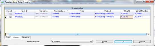
After downloading the receiver data files, Trimble Business Center was used to process the raw GPS data. Two separate TBC projects were created GPS PROJECT SESSION1 and GPS PROJECT SESSION 2. Session 1 consisted of the hour long GPS observations, and Session 2 consisted of the 30 minute GPS observations. Under the project settings I selected US Survey Feet, and specified US State Plane 1983, California Zone 2 0402, NAD 1983 (Conus) ( Moldensky), GEIOD09 (Conus). A data collector was not used during the field data collection portion of this project, the Method had to be changed from the Antenna Phase Center to Hook using 4800 tape, and the respective Heights had to be entered in the Receiver Raw Data Check In screen. See the screen shot below.
Then the CORS sites, LNC2, P230 and P271 files were added to the project. See the screen shot below with the files added to the TBC project.
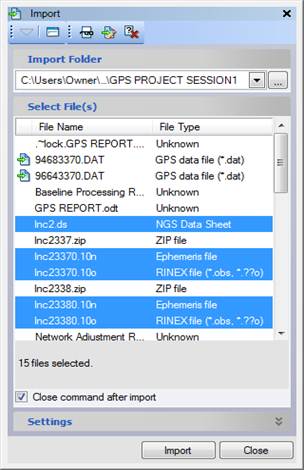
The .ds file is the NGS Data Sheet, .10n file is the Ephemeris file, .10o is the RINEX file (*obs,*.??o) were the files created from the Internet Download using TBC.
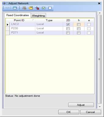
After all the CORS stations and the raw field data was in the respective project, the Baselines were processed, using the Process Baseline tool under the Survey menu. After the baselines were processed, the Adjust Network was performed holding the CORS station LNC2 fixed and the minimally constrained was performed.
Before I did the first adjustment a warning box appeared stating (see screen shot below):
There are still 12 unresolved project computation errors.
You should resolve these errors
before continuing.
Do you want to continue?
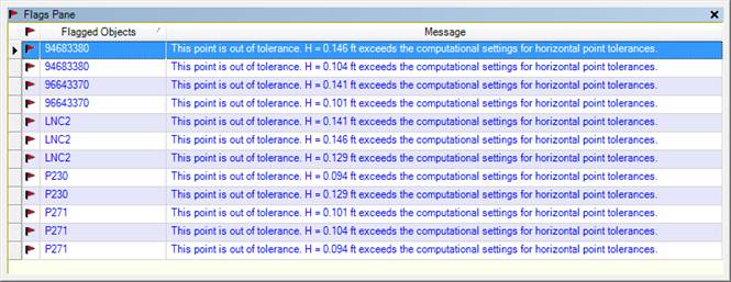
I just accepted these tolerance errors, by selecting Yes. It ran through the iterations and then this screen appeared.
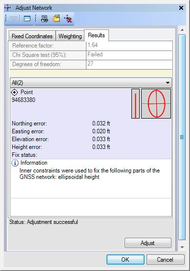
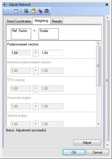
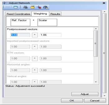
Then I selected the Weighting tab and selected the * at the Processed vectors: 1.64. This value can be changed by the user, I just accepted the default value and selected Adjust.
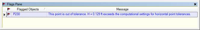
A window appeared stating there is still 1 error to be resolved (see screen shot below). I just accepted the error.
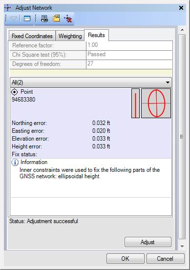
The adjustment passed the Chi Square test (95%). Below is a screen shot with the results.
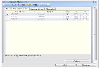
After performing the minimally constrained adjustment, the constrained
adjustment was performed holding all the CORS stations fixed (LNC2, P230 and
P271). There was still an error to be
resolved, but the error was accepted by selecting Yes. Above is a screen shot of the results.

The weighting tab was selected and 1.13 reference factor was selected using the * button. Then the constrained adjustment was performed again. Refer below to the screen shot with the new Ref. Factor.
PROJECT SUMMARY
After the minimally constrained was performed, the Baseline Processing Report, Network Adjustment Report and the Point Derivation Report were generated using the Reports menu. The results are displayed in the Appendix.
This process was repeated for the 30 minute GPS session. The reports for Session 2 are available in the Appendix.
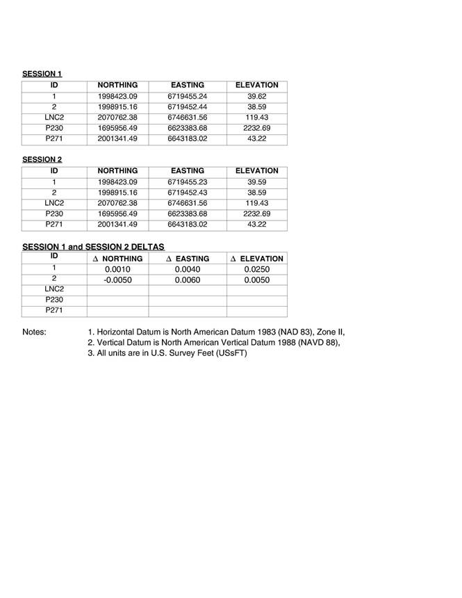
In the appendix a spreadsheet displays the points from the TBC processing. The point report displays the differences from the 2 sessions (1 hour and 30 minute GPS sessions). Also the OPUS data was compared to each respective session. The OPUS results are also available in the Appendix.
In reference to Table 1, the differences in Northing from Session 1 and Session 2 for points 1 and 2 were 0.001' and -0.005', respectively. The differences in Easting from Session 1 and Session 2 for points 1 and 2 were 0.004' and 0.006', respectively. The differences in Elevation (orthometric) from Session 1 and Session 2 for points 1 and 2 were 0.025' and 0.005', respectively. These differences are relatively insignificant for boundary surveying work and are acceptable differences.
In reference to Table 2, the differences in Northing from Session 1 and Session 1 OPUS for points 1 and 2 were 0.0573' and 0.0780', respectively. The differences in Easting from Session 2 and Session 2 OPUS for points 1 and 2 were 0.0563' and 0.0568', respectively. The differences in Elevation (orthometric) from Session 1 and Session 1 OPUS for points 1 and 2 were -0.0885' and -0.0365', respectively. The differences in Elevation (orthometric) from Session 2 and Session 2 OPUS for points 1 and 2 were -0.1038' and -0.0711', respectively. These differences are relatively insignificant for boundary surveying work and are acceptable differences.
The Horizontal Precision (Ratio) for points 1 and 2 was 1 : 37801 and had a 3D Precision (Ratio) of 1 : 37796 for GPS Session 1. The Horizontal Precision (Ratio) for point 1 and 2 was 1 : 27424 and had a 3D Precision (Ratio) of 1 : 27413 for GPS Session 2. The Semi-major axis for GPS Session 1 was 0.028' and Semi-minor axis was 0.017' and an Azimuth of 179° for both points 1 and 2. The Semi-major axis for GPS Session 2 was 0.034' and Semi-minor axis was 0.024' and an Azimuth of 176° for point 1. The Semi-major axis for GPS Session 2 was 0.036' and Semi-minor axis was 0.026' and an Azimuth of 176° for point 2. For Cadastral Project Control and Cadastral Project Control, these results are within the accuracy standards per the Network Accuracy Standards in Standards and Guidelines for Cadastral Surveys Using Global Positioning System Methods, page 1-4. Also the results fall within the 2-Centimeter Accuracy Classification per Table 2.1, Geospatial Positioning Accuracy Standards.
An important note is to take good notes while conducting a GPS control survey. This project did not require the use of a data collector, but even if you do use a data collector, a good set of field notes can sometime alleviate some problems when processing the field data. I was able to see an error I had in my field notes when performing the data checkin procedures. My height of instrument was denoted in the wrong location. But I was able to find and fix the error. Another issue occurred while in the field. The battery died for during the second session for point 2. This occupation time was only 17 minutes. Make sure that batteries are good and charged fully prior to conducting a field GPS survey.
Also I noticed some slight differences in the way CORPSCON does the calculations for latitude and longitude compared with the results from the processing with TBC. There are some slight differences in the ending decimal seconds, I noticed in the points table compared with the reports from TBC.
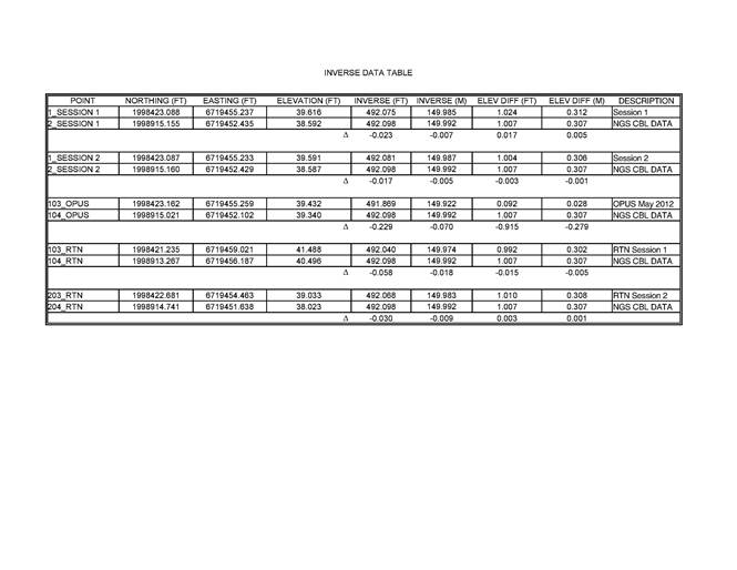
http://www.ngs.noaa.gov/CBLINES/BASELINES/ca
NGS published distances between the Calibration Base Line Monuments. The distance between the 0 meter and 150 meter monuments was 149.9919 meters (492.098'), and an elevation difference of 0.307 meters (1.007'). The inverse between PT 1 and PT 2 for Session 1 was 149.985 meters (492.075') or -0.007 meters (-0.023') compared with the published NGS Baseline Data Results. The inverse between PT 1 and PT 2 for Session 2 was 149.987 meters (492.081') or -0.005 meters (-0.017') compared with the published NGS Baseline Data Results. The inverse between PT 1 and PT 2 for OPUS was 149.992 meters (491.869') or -0.070 meters (-0.229') compared with the published NGS Baseline Data Results. The inverse between 103_RTN and 104_RTN was 149.974 meters (492.040') or -0.018 meters (-0.058') compared with the published NGS Baseline Data Results. The inverse between 203_RTN and 204_RTN for OPUS was 149.983 meters (492.0068') or -0.009 meters (-0.030') compared with the published NGS Baseline Data Results. Points 1_Session 1, 1_Session 2, 103_OPUS, 103_RTN and 203_RTN are the 0 meter CBL Monument location. Points 2_Session 1, 2_Session 2, 104_OPUS, 104_RTN and 204_RTN are the 150 meter CBL Monument location.
The largest error was encounter with the 2 OPUS solution reports -0.070 meters (-0.229’). Additional data needs to be collected and further analysis is required to verify this error.
REFERENCES
1. Standards and Guidelines for Cadastral Surveys Using Global Positioning System Methods (May 9, 2001, Version 1) by the United States Department of Agriculture-Forest Service and United States Department of the Interior-Bureau of Land Management
2. Geospatial Positioning Accuracy Standards, FGDC-STD-007-1998, Federal Geographic Data Committee, Part 2: Standards for Geodetic Networks.
NETWORK DIAGRAM
TABLES

APPENDIX
OPUSS REPORT POINT 1 SESSION 1
FILE:
94683370.DAT 000177784
6011 Warning -
OPUS-RS was able to find a set of reference stations
6011 with data suitable for use with your data
set However, your
6011 position does not fall within the polygon
enclosing these reference
6011 stations. This means that the geographic
interpolation algorithms
6011 performed within OPUS-RS must instead
perform extrapolation.
6011 Extrapolation, especially if your position
is far from the
6011 reference stations, is prone to error. Use
this solution with
6011 caution.
Your
station is 14.8 KM outside the
polygon enclosing the reference stations.
NGS OPUS-RS SOLUTION REPORT
========================
USER:
nlabedzki@parks.ca.gov
DATE: December 07, 2010
RINEX FILE: 9468337x.10o TIME: 18:33:56 UTC
SOFTWARE:
rsgps 1.35.1 RS10.prl 1.65 START: 2010/12/03 23:36:30
EPHEMERIS:
igr16125.eph [rapid]
STOP: 2010/12/04 00:36:15
NAV FILE:
brdc3370.10n OBS
USED: 5742 / 7110
: 81%
ANT NAME:
TRM4800 QUALITY IND. 17.35/ 43.12
ARP HEIGHT: 1.774 NORMALIZED RMS: 0.274
REF FRAME:
NAD_83(CORS96)(EPOCH:2002.0000)
ITRF00 (EPOCH:2010.92330)
X: -2602212.810(m) 0.012(m)
-2602213.656(m) 0.012(m)
Y: -4255172.352(m) 0.014(m) -4255171.009(m) 0.014(m)
Z: 3961893.885(m) 0.018(m) 3961893.896(m) 0.018(m)
LAT: 38 38 54.12087 0.009(m) 38 38 54.13541 0.009(m)
E
LON: 238 33 8.99967
0.011(m) 238 33 8.94085
0.011(m)
W
LON: 121 26 51.00033 0.011(m) 121 26 51.05915 0.011(m)
EL
HGT: -18.631(m) 0.022(m) -19.174(m) 0.022(m)
ORTHO
HGT: 12.048(m) 0.031(m) [NAVD88 (Computed using GEOID09)]
UTM COORDINATES STATE PLANE COORDINATES
UTM (Zone 10) SPC (0402 CA 2)
Northing (Y) [meters] 4278899.943 609120.558
Easting (X)
[meters] 635100.215 2048094.054
Convergence
[degrees] 0.96974345 0.34833370
Point Scale 0.99982477 0.99994349
Combined Factor 0.99982769 0.99994641
US NATIONAL GRID DESIGNATOR: 10SFH3510078899(NAD
83)
BASE STATIONS
USED
PID
DESIGNATION
LATITUDE LONGITUDE DISTANCE(m)
DG8213 P271 WOODLAND1_CA2004 CORS ARP N383926.446 W1214252.323 23266.1
AF9711 SUTB SUTTER BUTTES CORS ARP N391220.994 W1214914.100 69838.2
DK3587 CHO5 CHICO 5 CORS ARP N392557.483 W1213953.809 89077.7
DH3882 P230 MORGANTRTYCN2005 CORS ARP N374908.256 W1214710.981 96733.8
AM7021 OHLN OHLONE PARK CORS ARP N380022.493 W1221622.704 101439.1
AH9962 S300 LLNL SITE S300 CORS ARP N373959.410 W1213329.710 109421.7
DI1085 P181 MILLERKNOXCN2005 CORS ARP N375452.343 W1222236.261 115086.7
AF9690 CHAB CHAB_BARD_CN1991 CORS ARP N374326.799 W1220709.461 118275.3
DK6402 P336 HUBBARDRDGCN2007 CORS ARP N393141.072 W1222549.684 129500.7
NEAREST NGS PUBLISHED CONTROL POINT
JS4140
MC CLELLAN AFB W WATER TANK
N383927.617 W1212518.299 2466.6
This position and the above vector components were
computed without any knowledge by the National Geodetic Survey regarding the
equipment or field operating procedures used.
OPUS REPORT POINT 2
SESSION 1
FILE: 96643370.DAT 000177787
6011 Warning -
OPUS-RS was able to find a set of reference stations
6011 with data suitable for use with your data
set However, your
6011 position does not fall within the polygon
enclosing these reference
6011 stations. This means that the geographic
interpolation algorithms
6011 performed within OPUS-RS must instead
perform extrapolation.
6011 Extrapolation, especially if your position
is far from the
6011 reference stations, is prone to error. Use
this solution with
6011 caution.
Your
station is 14.8 KM outside the
polygon enclosing the reference stations.
NGS OPUS-RS
SOLUTION REPORT
========================
USER:
nlabedzki@parks.ca.gov
DATE: December 07, 2010
RINEX FILE: 9664337x.10o TIME: 18:36:58 UTC
SOFTWARE:
rsgps 1.35.1 RS12.prl 1.65 START: 2010/12/03 23:32:30
EPHEMERIS:
igr16125.eph [rapid]
STOP: 2010/12/04 00:37:45
NAV FILE:
brdc3370.10n OBS USED: 5805 /
7713 : 75%
ANT NAME:
TRM4800 QUALITY
IND. 14.06/113.55
ARP HEIGHT: 1.596 NORMALIZED RMS: 0.267
REF FRAME:
NAD_83(CORS96)(EPOCH:2002.0000)
ITRF00 (EPOCH:2010.92330)
X: -2602163.782(m) 0.012(m) -2602164.628(m) 0.012(m)
Y: -4255092.284(m) 0.017(m) -4255090.941(m) 0.017(m)
Z: 3962010.852(m) 0.016(m) 3962010.863(m) 0.016(m)
LAT: 38 38 58.98491 0.009(m) 38 38 58.99946 0.009(m)
E
LON: 238 33 9.00190
0.011(m) 238 33 8.94308
0.011(m)
W
LON: 121 26 50.99810 0.011(m) 121 26 51.05692 0.011(m)
EL
HGT: -18.903(m)
0.022(m)
-19.447(m) 0.022(m)
ORTHO
HGT: 11.774(m) 0.031(m) [NAVD88 (Computed using GEOID09)]
UTM COORDINATES STATE PLANE COORDINATES
UTM (Zone 10) SPC (0402 CA 2)
Northing (Y) [meters] 4279049.883 609270.534
Easting (X)
[meters] 635097.731 2048093.196
Convergence
[degrees] 0.96977243 0.34833409
Point Scale 0.99982476 0.99994331
Combined Factor 0.99982772 0.99994628
US NATIONAL GRID DESIGNATOR: 10SFH3509779049(NAD
83)
BASE STATIONS
USED
PID
DESIGNATION
LATITUDE LONGITUDE DISTANCE(m)
DG8213 P271 WOODLAND1_CA2004 CORS ARP N383926.446 W1214252.323 23260.0
AF9711 SUTB SUTTER BUTTES CORS ARP N391220.994 W1214914.100 69705.2
DK3587 CHO5 CHICO 5 CORS ARP N392557.483 W1213953.809 88931.1
DH3882 P230 MORGANTRTYCN2005 CORS ARP N374908.256 W1214710.981 96876.5
AM7021 OHLN OHLONE PARK CORS ARP N380022.493 W1221622.704 101544.1
AH9962 S300 LLNL SITE S300 CORS ARP N373959.410 W1213329.710 109571.1
DI1085 P181 MILLERKNOXCN2005 CORS ARP N375452.343 W1222236.261 115192.4
AF9690 CHAB CHAB_BARD_CN1991 CORS ARP N374326.799 W1220709.461 118405.2
DK6402 P336 HUBBARDRDGCN2007 CORS ARP N393141.072 W1222549.684 129387.1
NEAREST NGS PUBLISHED CONTROL POINT
JS4140
MC CLELLAN AFB W WATER TANK
N383927.617 W1212518.299 2407.2
This position and the above vector components were
computed without any knowledge by the National Geodetic Survey regarding the
equipment or field operating procedures used.
OPUS REPORT POINT 1
SESSION 2
FILE: 94683380.DAT 000177789
6011 Warning -
OPUS-RS was able to find a set of reference stations
6011 with data suitable for use with your data
set However, your
6011 position does not fall within the polygon
enclosing these reference
6011 stations. This means that the geographic
interpolation algorithms
6011 performed within OPUS-RS must instead
perform extrapolation.
6011 Extrapolation, especially if your position
is far from the
6011 reference stations, is prone to error. Use
this solution with
6011 caution.
Your
station is 14.8 KM outside the
polygon enclosing the reference stations.
NGS OPUS-RS
SOLUTION REPORT
========================
USER:
nlabedzki@parks.ca.gov
DATE: December 07, 2010
RINEX FILE: 9468338a.10o TIME: 18:36:55 UTC
SOFTWARE:
rsgps 1.35.1 RS26.prl 1.65 START: 2010/12/04 00:42:45
EPHEMERIS:
igr16126.eph [rapid] STOP: 2010/12/04 01:13:00
NAV FILE:
brdc3380.10n OBS
USED: 3294 / 3627
: 91%
ANT NAME:
TRM4800 QUALITY
IND. 6.35/ 49.91
ARP HEIGHT: 1.774 NORMALIZED RMS: 0.314
REF FRAME:
NAD_83(CORS96)(EPOCH:2002.0000)
ITRF00 (EPOCH:2010.92340)
X: -2602212.833(m) 0.012(m) -2602213.679(m) 0.012(m)
Y: -4255172.385(m) 0.016(m) -4255171.042(m) 0.016(m)
Z: 3961893.917(m) 0.020(m) 3961893.928(m) 0.020(m)
LAT: 38 38 54.12086 0.009(m) 38 38 54.13541 0.009(m)
E
LON: 238 33 8.99957
0.010(m) 238 33 8.94075
0.010(m)
W
LON: 121 26 51.00043 0.010(m) 121 26 51.05925 0.010(m)
EL
HGT: -18.580(m) 0.025(m) -19.123(m) 0.025(m)
ORTHO
HGT: 12.099(m) 0.033(m) [NAVD88 (Computed using GEOID09)]
UTM COORDINATES STATE PLANE COORDINATES
UTM (Zone 10) SPC (0402 CA 2)
Northing (Y) [meters] 4278899.943 609120.558
Easting (X)
[meters] 635100.213 2048094.052
Convergence
[degrees] 0.96974343 0.34833368
Point Scale 0.99982477 0.99994349
Combined Factor 0.99982768 0.99994640
US NATIONAL GRID DESIGNATOR: 10SFH3510078899(NAD
83)
BASE STATIONS
USED
PID
DESIGNATION LATITUDE LONGITUDE DISTANCE(m)
DG8213 P271 WOODLAND1_CA2004 CORS ARP N383926.446 W1214252.323 23266.1
AF9711 SUTB SUTTER BUTTES CORS ARP N391220.994 W1214914.100 69838.2
DK3587 CHO5 CHICO 5 CORS ARP N392557.483 W1213953.809 89077.7
DH3882 P230 MORGANTRTYCN2005 CORS ARP N374908.256 W1214710.981 96733.8
AM7021 OHLN OHLONE PARK CORS ARP N380022.493 W1221622.704 101439.1
AH9962 S300 LLNL SITE S300 CORS ARP N373959.410 W1213329.710 109421.7
DI1085 P181 MILLERKNOXCN2005 CORS ARP N375452.343 W1222236.261 115086.7
AF9690 CHAB CHAB_BARD_CN1991 CORS ARP N374326.799 W1220709.461 118275.3
DK6402 P336 HUBBARDRDGCN2007 CORS ARP N393141.072 W1222549.684 129500.7
NEAREST NGS PUBLISHED CONTROL POINT
JS4140
MC CLELLAN AFB W WATER TANK
N383927.617 W1212518.299 2466.6
This position and the above vector components were
computed without any knowledge by the National Geodetic Survey regarding the
equipment or field operating procedures used.
OPUS REPORT POINT 2
SESSION 2
FILE:
96643380.DAT 000177791
6011 Warning -
OPUS-RS was able to find a set of reference stations
6011 with data suitable for use with your data
set However, your
6011 position does not fall within the polygon
enclosing these reference
6011 stations. This means that the geographic
interpolation algorithms
6011 performed within OPUS-RS must instead
perform extrapolation.
6011 Extrapolation, especially if your position
is far from the
6011 reference stations, is prone to error. Use
this solution with
6011 caution.
Your
station is 14.8 KM outside the
polygon enclosing the reference stations.
NGS OPUS-RS
SOLUTION REPORT
========================
USER:
nlabedzki@parks.ca.gov
DATE: December 07, 2010
RINEX FILE: 9664338a.10o TIME: 18:35:35 UTC
SOFTWARE:
rsgps 1.35.1 RS40.prl 1.65 START: 2010/12/04 00:41:00
EPHEMERIS:
igr16126.eph [rapid]
STOP: 2010/12/04 00:58:00
NAV FILE:
brdc3380.10n OBS
USED: 2061 / 2151
: 96%
ANT NAME:
TRM4800 QUALITY
IND. 18.96/ 23.80
ARP HEIGHT: 1.596 NORMALIZED RMS: 0.310
REF FRAME:
NAD_83(CORS96)(EPOCH:2002.0000)
ITRF00 (EPOCH:2010.92338)
X: -2602163.787(m) 0.013(m) -2602164.633(m) 0.013(m)
Y: -4255092.284(m) 0.020(m) -4255090.941(m) 0.020(m)
Z: 3962010.864(m) 0.021(m) 3962010.875(m) 0.021(m)
LAT: 38 38 58.98516 0.010(m) 38 38 58.99971 0.010(m)
E
LON: 238 33 9.00172
0.010(m) 238 33 8.94290
0.010(m)
W
LON: 121 26 50.99828 0.010(m) 121 26 51.05710 0.010(m)
EL
HGT: -18.894(m) 0.028(m) -19.437(m) 0.028(m)
ORTHO
HGT: 11.783(m) 0.036(m) [NAVD88 (Computed using GEOID09)]
UTM COORDINATES STATE PLANE COORDINATES
UTM (Zone 10) SPC (0402 CA 2)
Northing (Y) [meters] 4279049.890 609270.542
Easting (X)
[meters] 635097.727 2048093.192
Convergence
[degrees] 0.96977240 0.34833406
Point Scale 0.99982476 0.99994331
Combined Factor 0.99982772 0.99994628
US NATIONAL GRID DESIGNATOR: 10SFH3509779049(NAD
83)
BASE STATIONS USED
PID
DESIGNATION
LATITUDE LONGITUDE DISTANCE(m)
DG8213 P271 WOODLAND1_CA2004 CORS ARP N383926.446 W1214252.323 23260.0
AF9711 SUTB SUTTER BUTTES CORS ARP N391220.994 W1214914.100 69705.2
DK3587 CHO5 CHICO 5 CORS ARP N392557.483 W1213953.809 88931.0
DH3882 P230 MORGANTRTYCN2005 CORS ARP N374908.256 W1214710.981 96876.5
AM7021 OHLN OHLONE PARK CORS ARP N380022.493 W1221622.704 101544.1
AH9962 S300 LLNL SITE S300 CORS ARP N373959.410 W1213329.710 109571.1
DI1085 P181 MILLERKNOXCN2005 CORS ARP N375452.343 W1222236.261 115192.4
AF9690 CHAB CHAB_BARD_CN1991 CORS ARP N374326.799 W1220709.461 118405.2
DK6402 P336 HUBBARDRDGCN2007 CORS ARP N393141.072 W1222549.684 129387.1
NEAREST NGS PUBLISHED CONTROL POINT
JS4140
MC CLELLAN AFB W WATER TANK
N383927.617 W1212518.299 2407.2
This position and the above vector components were
computed without any knowledge by the National Geodetic Survey regarding the
equipment or field operating procedures used.
NGS CORS DATASHEET
LNC2
The NGS Data Sheet
See file
dsdata.txt for more information about the datasheet.
DATABASE =
,PROGRAM = datasheet, VERSION = 7.85
1
National Geodetic Survey,
Retrieval Date = DECEMBER 9, 2010
DF7467
***********************************************************************
DF7467 CORS
- This is a GPS Continuously
Operating Reference Station.
DF7467 DESIGNATION -
LINCOLN 2 CORS ARP
DF7467 CORS_ID
- LNC2
DF7467 PID
- DF7467
DF7467 STATE/COUNTY-
CA/PLACER
DF7467 USGS QUAD
- ROSEVILLE (1992)
DF7467
DF7467 *CURRENT SURVEY
CONTROL
DF7467 ___________________________________________________________________
DF7467* NAD
83(CORS)- 38 50 47.41366(N) 121 21 01.92412(W) ADJUSTED
DF7467*
NAVD 88 - **(meters) **(feet)
DF7467 ___________________________________________________________________
DF7467 EPOCH DATE
- 2002.00
DF7467 X
- -2,587,855.534 (meters) COMP
DF7467 Y
- -4,247,830.147 (meters) COMP
DF7467 Z
- 3,979,063.930 (meters) COMP
DF7467 ELLIP HEIGHT- 6.381 (meters) (03/??/08) ADJUSTED
DF7467 GEOID HEIGHT- -30.02
(meters)
GEOID09
DF7467 HORZ ORDER
- SPECIAL (CORS)
DF7467 ELLP ORDER
- SPECIAL (CORS)
DF7467
DF7467.ITRF
positions are available for this station.
DF7467.The
coordinates were established by GPS observations
DF7467.and
adjusted by the National Geodetic Survey in March 2008.
DF7467.The
coordinates are valid at the epoch date displayed above.
DF7467.The
epoch date for horizontal control is a decimal equivalence
DF7467.of
Year/Month/Day.
DF7467
DF7467
DF7467.The
PID for the CORS L1 Phase Center is DG6998.
DF7467
DF7467.The
XYZ, and position/ellipsoidal ht. are equivalent.
DF7467
DF7467.The
ellipsoidal height was determined by GPS observations
DF7467.and
is referenced to NAD 83.
DF7467
DF7467.The
geoid height was determined by GEOID09.
DF7467
DF7467; North East Units Scale Factor Converg.
DF7467;SPC
CA 2 - 631,169.636 2,056,377.412 MT
0.99992327 +0 24 34.1
DF7467;SPC
CA 2 - 2,070,762.38 6,746,631.56
sFT 0.99992327 +0 24 34.1
DF7467
DF7467! -
Elev Factor x Scale Factor = Combined Factor
DF7467!SPC
CA 2 - 0.99999900
x 0.99992327 =
0.99992227
DF7467
DF7467 SUPERSEDED SURVEY
CONTROL
DF7467
DF7467 NAD 83(CORS)-
38 50 47.41360(N) 121 21
01.92404(W) AD(2002.00) c
DF7467 ELLIP H (10/??/04) 6.389
(m) GP(2002.00) c c
DF7467 NAD 83(CORS)-
38 50 47.41355(N) 121 21
01.92408(W) AD(2002.00) c
DF7467 ELLIP H (08/??/03) 6.277
(m) GP(2002.00)
c c
DF7467
DF7467.Superseded values are not recommended
for survey control.
DF7467.NGS
no longer adjusts projects to the NAD 27 or NGVD 29 datums.
DF7467.See
file dsdata.txt to determine how the superseded data were derived.
DF7467
DF7467_U.S.
NATIONAL GRID SPATIAL ADDRESS: 10SFJ4314201035(NAD 83)
DF7467_MARKER: STATION IS THE ANTENNA
REFERENCE POINT OF THE GPS ANTENNA
DF7467
DF7467 STATION DESCRIPTION
DF7467
DF7467'DESCRIBED BY NATIONAL GEODETIC SURVEY
2008
DF7467'STATION IS A GPS CORS. LATEST INFORMATION INCLUDING POSITIONS AND
DF7467'VELOCITIES ARE AVAILABLE IN THE
COORDINATE AND LOG FILES ACCESSIBLE
DF7467'BY
ANONYMOUS FTP OR THE WORLDWIDE WEB.
DF7467'
FTP CORS.NGS.NOAA.GOV: CORS/COORD
AND CORS/STATION_LOG
DF7467'
HTTP://WWW.NGS.NOAA.GOV/CORS.
***
retrieval complete.
Elapsed
Time = 00:00:00
NGS CORS DATASHEET
P271
The NGS Data Sheet
See file
dsdata.txt for more information about the datasheet.
DATABASE =
,PROGRAM = datasheet, VERSION = 7.85
1
National Geodetic Survey,
Retrieval Date = DECEMBER 9, 2010
DG8213
***********************************************************************
DG8213 CORS
- This is a GPS Continuously
Operating Reference Station.
DG8213 DESIGNATION -
WOODLAND1_CA2004 CORS ARP
DG8213 CORS_ID
- P271
DG8213 PID
- DG8213
DG8213 STATE/COUNTY-
CA/YOLO
DG8213 USGS QUAD
- GRAYS BEND (1975)
DG8213
DG8213 *CURRENT SURVEY
CONTROL
DG8213
___________________________________________________________________
DG8213* NAD
83(CORS)- 38 39 26.44614(N) 121 42 52.32300(W) ADJUSTED
DG8213*
NAVD 88 - **(meters) **(feet)
DG8213
___________________________________________________________________
DG8213 EPOCH DATE
- 2002.00
DG8213 X
- -2,621,689.341 (meters) COMP
DG8213 Y
- -4,242,469.262 (meters) COMP
DG8213 Z
- 3,962,672.905 (meters) COMP
DG8213 ELLIP HEIGHT- -17.677 (meters) (03/??/08) ADJUSTED
DG8213 GEOID HEIGHT- -30.85
(meters)
GEOID09
DG8213 HORZ ORDER
- SPECIAL (CORS)
DG8213 ELLP ORDER
- SPECIAL (CORS)
DG8213
DG8213.ITRF
positions are available for this station.
DG8213.The
coordinates were established by GPS observations
DG8213.and
adjusted by the National Geodetic Survey in March 2008.
DG8213.The
coordinates are valid at the epoch date displayed above.
DG8213.The
epoch date for horizontal control is a decimal equivalence
DG8213.of Year/Month/Day.
DG8213
DG8213
DG8213.The
PID for the CORS L1 Phase Center is DG8214.
DG8213
DG8213.The
XYZ, and position/ellipsoidal ht. are equivalent.
DG8213
DG8213.The
ellipsoidal height was determined by GPS observations
DG8213.and
is referenced to NAD 83.
DG8213
DG8213.The
geoid height was determined by GEOID09.
DG8213
DG8213; North East Units Scale Factor Converg.
DG8213;SPC
CA 2 - 610,010.105 2,024,846.233 MT
0.99994232 +0 10 47.9
DG8213;SPC
CA 2 - 2,001,341.49 6,643,183.02
sFT 0.99994232 +0 10 47.9
DG8213
DG8213! -
Elev Factor x Scale Factor = Combined Factor
DG8213!SPC
CA 2 - 1.00000277
x 0.99994232 =
0.99994509
DG8213
DG8213 SUPERSEDED SURVEY
CONTROL
DG8213
DG8213 NAD 83(CORS)-
38 39 26.44585(N) 121 42
52.32283(W) AD(2002.00) c
DG8213 ELLIP H (12/??/04) -17.670
(m) GP(2002.00)
c c
DG8213
DG8213.Superseded values are not recommended
for survey control.
DG8213.NGS
no longer adjusts projects to the NAD 27 or NGVD 29 datums.
DG8213.See
file dsdata.txt to determine how the superseded data were derived.
DG8213
DG8213_U.S.
NATIONAL GRID SPATIAL ADDRESS: 10SFH1184779536(NAD 83)
DG8213_MARKER: STATION IS THE ANTENNA
REFERENCE POINT OF THE GPS ANTENNA
DG8213
DG8213 STATION DESCRIPTION
DG8213
DG8213'DESCRIBED BY NATIONAL GEODETIC SURVEY
2008
DG8213'STATION IS A GPS CORS. LATEST INFORMATION INCLUDING POSITIONS AND
DG8213'VELOCITIES
ARE AVAILABLE IN THE COORDINATE AND LOG FILES ACCESSIBLE
DG8213'BY
ANONYMOUS FTP OR THE WORLDWIDE WEB.
DG8213'
FTP CORS.NGS.NOAA.GOV: CORS/COORD
AND CORS/STATION_LOG
DG8213'
HTTP://WWW.NGS.NOAA.GOV/CORS.
***
retrieval complete.
Elapsed
Time = 00:00:00
NGS CORS DATASHEET
P230
The NGS Data Sheet
See file
dsdata.txt for more information about the datasheet.
DATABASE =
,PROGRAM = datasheet, VERSION = 7.85
1
National Geodetic Survey,
Retrieval Date = DECEMBER 9, 2010
DH3882
***********************************************************************
DH3882 CORS
- This is a GPS Continuously
Operating Reference Station.
DH3882 DESIGNATION -
MORGANTRTYCN2005 CORS ARP
DH3882 CORS_ID
- P230
DH3882 PID
-
DH3882
DH3882 STATE/COUNTY-
CA/CONTRA COSTA
DH3882 USGS QUAD
- TASSAJARA (1991)
DH3882
DH3882 *CURRENT SURVEY
CONTROL
DH3882
___________________________________________________________________
DH3882* NAD
83(CORS)- 37 49 08.25696(N) 121 47 10.98199(W) ADJUSTED
DH3882*
NAVD 88 - **(meters) **(feet)
DH3882
___________________________________________________________________
DH3882 EPOCH DATE
- 2002.00
DH3882 X
- -2,657,624.652 (meters) COMP
DH3882 Y
- -4,288,585.085 (meters) COMP
DH3882 Z
- 3,889,987.458 (meters) COMP
DH3882 ELLIP HEIGHT- 648.534 (meters) (03/??/08) ADJUSTED
DH3882 GEOID HEIGHT- -31.99
(meters)
GEOID09
DH3882 HORZ ORDER
- SPECIAL (CORS)
DH3882 ELLP ORDER
- SPECIAL (CORS)
DH3882
DH3882.ITRF
positions are available for this station.
DH3882.The
coordinates were established by GPS observations
DH3882.and
adjusted by the National Geodetic Survey in March 2008.
DH3882.The
coordinates are valid at the epoch date displayed above.
DH3882.The
epoch date for horizontal control is a decimal equivalence
DH3882.of
Year/Month/Day.
DH3882
DH3882
DH3882.The
PID for the CORS L1 Phase Center is DK2751.
DH3882
DH3882.The
XYZ, and position/ellipsoidal ht. are equivalent.
DH3882
DH3882.The
ellipsoidal height was determined by GPS observations
DH3882.and
is referenced to NAD 83.
DH3882
DH3882.The
geoid height was determined by GEOID09.
DH3882
DH3882; North East Units Scale Factor Converg.
DH3882;SPC
CA 3 - 647,158.010 1,886,748.050 MT
0.99992988 -0 47 15.2
DH3882;SPC
CA 3 - 2,123,217.57 6,190,105.89
sFT 0.99992988 -0 47 15.2
DH3882
DH3882! -
Elev Factor x Scale Factor = Combined Factor
DH3882!SPC
CA 3 - 0.99989824
x 0.99992988 =
0.99982813
DH3882
DH3882 SUPERSEDED SURVEY CONTROL
DH3882
DH3882 NAD 83(CORS)-
37 49 08.25640(N) 121 47
10.98236(W) AD(2002.00) c
DH3882 ELLIP H (06/??/05) 648.551
(m) GP(2002.00)
c c
DH3882
DH3882.Superseded values are not recommended
for survey control.
DH3882.NGS
no longer adjusts projects to the NAD 27 or NGVD 29 datums.
DH3882.See
file dsdata.txt to determine how the superseded data were derived.
DH3882
DH3882_U.S.
NATIONAL GRID SPATIAL ADDRESS: 10SFG0681586422(NAD 83)
DH3882_MARKER: STATION IS THE ANTENNA
REFERENCE POINT OF THE GPS ANTENNA
DH3882
DH3882 STATION DESCRIPTION
DH3882
DH3882'DESCRIBED BY NATIONAL GEODETIC SURVEY
2008
DH3882'STATION IS A GPS CORS. LATEST INFORMATION INCLUDING POSITIONS AND
DH3882'VELOCITIES ARE AVAILABLE IN THE
COORDINATE AND LOG FILES ACCESSIBLE
DH3882'BY
ANONYMOUS FTP OR THE WORLDWIDE WEB.
DH3882'
FTP CORS.NGS.NOAA.GOV: CORS/COORD
AND CORS/STATION_LOG
DH3882'
HTTP://WWW.NGS.NOAA.GOV/CORS.
*** retrieval
complete.
Elapsed
Time = 00:00:00
SESSION 1 BASELINE
PROCESSING REPORT