| Title Elk Grove Crimes | |||||||||||||||||||||||
|
Author Information Hervey Lee American River College, Geography 350: Data Acquisition in GIS herbs916@hotmail.com
| Abstract The project purpose is to compare the crime rates between City of Sacramento and Elk Grove. Currently, this project is incomplete due to the inability to obtain the data from the City of Sacramento and the amount of time. The project looked at a 1 mile radius and examined the crime rates from high schools. The following shows the ranking order of highest crimes: 1. Laguna Creek High School 2. Cosumnes Oaks High School 3. Monterey Trail High School
| Introduction This project will compare the City of Elk Grove neighborhoods and examine the crime rates in the city. The neighborhoods are based off from high school. This was chosen because there are major intersection around the community. Elk Grove Police Department has a partnership with CrimesReport.com and it shows where crimes occur and what type. These crime types are theft, theft from vehicle, theft of vehicle, robbery, breaking and entering, and assault. The following link is the City of Elk Grove Crime Report website; http://www.elkgrovepd.org/information/crime-stats.asp.
| Background CrimeReports.com utilizes Google Map and indicates where crimes occurred and type. They do not show the exact location of the crime but gave an approximate street number and name. The following image is an example 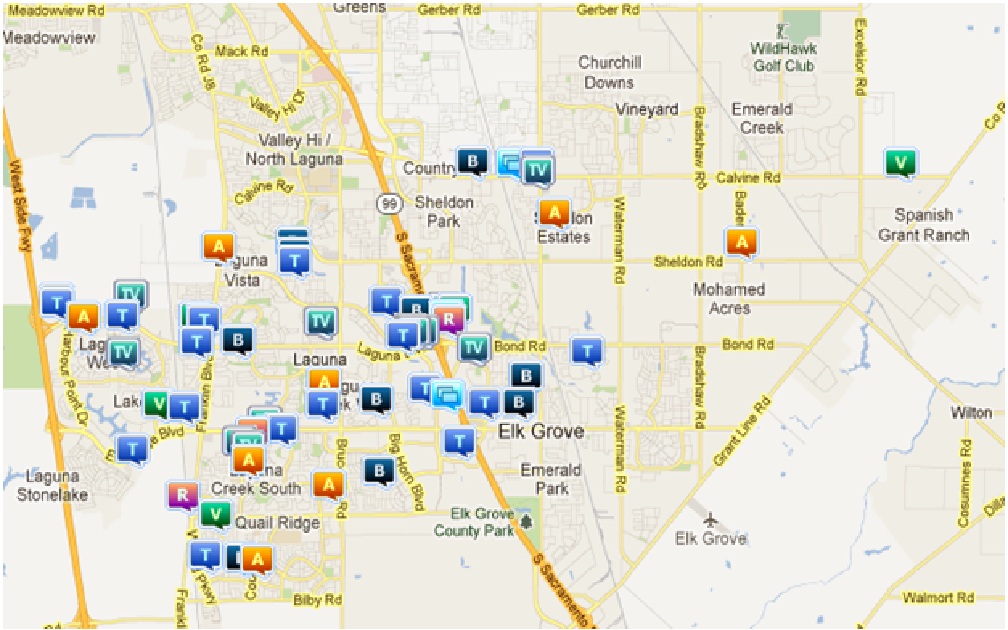 The letters indicates the type of crimes. • A - Assault • T - Theft • R - Robbery • B - Breaking and Entering • TV - Theft from Vehicle • V - Theft of Vehicle • Square boxes - More than 1 crimes have occurred
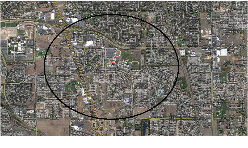
| Method Microsoft Excel was used to gather all the information from CrimeReports. The information can be seem in the Excel file; data.xlsx. Other information that was obtained was parcel for the County of Sacramento. With ArcMap, the parcel and the data were used to see where the crimes were located within the 1 mile radius. The data was first geocoded into the parcel.shp file. There were 1 unmatched address but was corrected. The following are the addresses used for the high schools:
| Result The following tables shown below are the results from ArcMap: 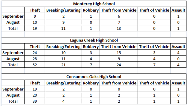 The list below indicates the highest crime rate: 1. Laguna Creek High School 2. Cosumnes Oaks High School 3. Monterey Trail High School
| Analysis There are a multiple reasons on Laguna Creek High School having the highest crime rate between the month of September and August. These reasons were: • An area of a circle • In the center of the City of Elk Grove • Near 4 major intersection with shopping centers and surrounded by residential area. Cosumnes Oak High School was the safest area. It had low crime rates in breaking and entering, robbery, theft from vehicle, theft of vehicle and assault, but had the second highest in theft. This did not make a lot of sense because theft, theft from vehicle, and robbery can be categorize together because they are very similar to each other. All three are related into some form of stealing. Because of where the school is located, they had a low crime rate. The population within this area is low compare because of its surrounding. The result might have been different if all of the data were received. If the data was double because of the shape within Monterey Trail and Cosumnes Oaks High School, the crime rates would be closer to each other; however, Laguna Creek would still have the highest crime rate. It would have the highest crimes in robbery, theft of vehicle and assault. Monterey Trail High School would have the highest theft and breaking and entering and Cosumnes Oaks High School would have the highest theft. Laguna Creek High School continues to have the highest crime rate.
| Conclusion The crime rates were the highest for Laguna Creek High School. It is located near major retail stores such as, Lowes, Raley, Walgreens, and Rite Aids. Monterey Trail High School was expected to have the highest crime rates because of a location that is similar to Laguna Creek High School, but with a highway nearby; Cosumnes Oak High School could have the highest because there are a few stores in its surrounding. It was surprising that Monterey Trail High School did not have the highest crime rate out of the three schools. The nearby highway allows a quick getaway. This can still be proven correct if the data from the City of Sacramento is obtained. This project is currently incomplete. Originally, the purpose of this project was to compare the crime rates between the City of Sacramento and Elk Grove. This is a smaller project leading up to a bigger one. City of Elk Grove is close to half way completed. The following is a list of high schools that have not been done currently: • Elk Grove High School • Franklin High School • Pleasant Grove High School • Lutheran High School Once these high schools are completed, the project will move towards the City of Sacramento and from there the project can compare the two Cities with each other. | ||||||||||||||||