Title
Can GIS Be Incorporated Into Genealogy Research?
Author Information
Andrew J Lightfoot
American River College, Geography 350: Data Acquisition in GIS; Fall 2012
Contact Information (ajlcalifornia@gmail.com)
Abstract
This paper considers the integration of GIS into genealogy research,
particularly the interaction between the programs Family Tree Builder, Google
Earth, and ArcGIS Explorer. I consider the merits of mapping locations and look
at additional features I would like to include in the future. After importing an Excel spreadsheet
containing geospatial data from My Family Tree Builder to Google Earth, I
selected six locations to create a tour for the viewer. To test the
compatibility between the two mapping applications I exported my map and tour
as a KML file to ArcGIS Explorer. I found that GIS is a beneficial addition to
genealogy as it allows for a visual interpretation of data, revealing patterns
and correlations not previously apparent.
Introduction
The decision to map my
family’s genealogy comes from extensive research on my family history.
Approximately three years ago my wife and I became curious about where in
Scotland my family had originated. In order to complement our research from
historical records, I decided to visualize the places where my ancestors had
lived and worked, ultimately resulting in a KML file created in Google Earth.
After learning about ArcGIS Explorer’s KML compatibility I also wanted to
see how easy it was to transition between the two programs.
I feel that a project such as genealogy is ideally suited to GIS as having a visual interpretation of the data helps the investigator to see trends and correlations not previously apparent. Furthermore having maps to share with family members fosters a more stimulating experience than simply pages of written information.
Background
There are several websites available on line to help users find and store genealogy data, such as Ancestory.com and MyHeritage.com, however none provides the option to map locations in geospatial detail. It is my hypothesis that by adding the ability to search records by physical location the user can not only expand upon their own knowledge, but also better educate those with similar interests.
The software application Family Tree Builder is available free from the website MyHeritage.com. It is available on Windows only and can be downloaded in 37 languages.
From the MyHeritage.com website: “Users may add birth, death, and marriage dates; notes about where their ancestors lived, their profession, hobbies and interests; and picture of ancestors. The program can also create charts that show how any two people are related. Users can build their family tree either offline or on a secure online site, and offline trees can be published to a family site.”
Perhaps the most useful feature of Family Tree Builder is the
software’s ability to search other databases for similar tree patterns,
thus enabling users to fill in any gaps in their own data.
The vast majority of names, dates, and locations came from
the website scotlandspeople.com. This is a government run site that allows
access to birth certificates, death notices, marriage licenses, court orders,
wills etc. The site can be accessed from anywhere in the world and is the
online equivalent of the Scottish Records Office in Edinburgh.
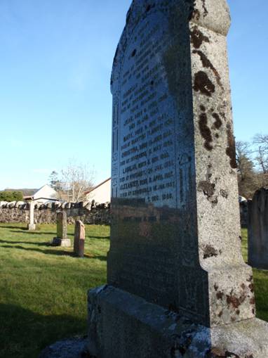
This headstone lists relatives going as far back as my great, great,
great, GREAT grandparents! The headstone is in Tomnacross Churchyard, in the village of Kiltarlity west of Inverness.
UTM: 30V 410425 6367259
Methods
After getting some brief details from my parents, we
downloaded a software program called ‘Family Tree Builder’ to
assist in the organization of data. After gaining access to such sites as
Scotland’s People the database now includes 226 people, with many more
still to be discovered.
Transitioning the data from database to Google Earth was made simple by Google’s ability to import Excel worksheets and geo-reference addresses.
With the locations entered into
Google Earth I decided upon six that best represent where my family have lived.
I created a tour around these six locations to animate the project and make it
more visually appealing.
|
Location |
Coordinates |
Event |
Date |
|
Kiltarlity |
UTM 30V 410425 6367259 |
Birthplace of Alexander MacBean |
1857 |
|
Edinburgh |
UTM 30U 488205 6200871 |
Marriage of Alexander MacBean to Agnes Greig Paul |
1886 |
|
Hawick |
UTM 30U 513733 6142813 |
Birthplace of John Elliot |
1887 |
|
Glasserton |
UTM 30U 407619 6081295 |
Birthplace of John Marshall |
1891 |
|
Glen Luce |
UTM 30U 383801 6082754 |
John Marshall married Mary Ann Baillie |
1914 |
|
Mochrum |
UTM 30U 383801 6082746 |
Birthplace of Walter Ross Hunter Marshall |
1923 |
In class this semester I learned of ArcGIS Explorer, ESRI’s attempt at competing with Google Earth. Given that my file was created as a KML file, and Explorer recognizes KML, I felt this would be a good opportunity to see how user friendly the application is.
Results
At any time the Family Tree Builder can produce a report of all the names in its database. This report is divided into such categories as Ancestry, Family Trees, and Index of Places.
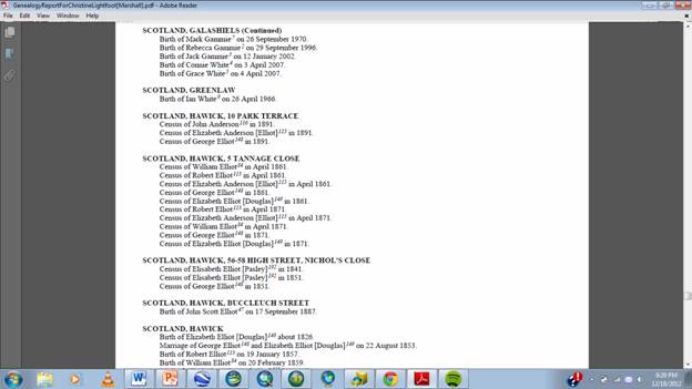
Helpfully the program also
stores the locations in an Excel spreadsheet, which was easy to import into
Google Earth, saving a very large amount of time not typing each address in
singularly.
One drawback I discovered was that whilst
Google Earth imported the locations, it was not able to transfer over the
person or event tied to that location. For the purposes of this paper it was
not necessary to have more than 5 or 6 examples,
however I’d like to ultimately map the location of all the births,
deaths, and marriages in my family. This will require a large time commitment
in terms of matching people with places.
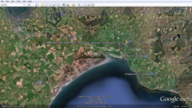
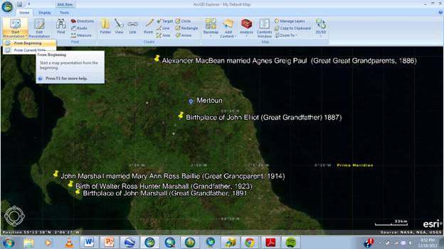
The example above shows I
have annotated one location with information of the event that took place
there.
The blue labels indicate
other entries in the Index of Places that have not been tied to an event yet.
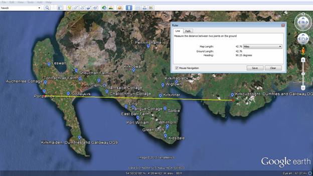
The image above indicates an
array of locations concentrated within a very small area of the southwest of
Scotland, a detail not previously obvious in the printed list of addresses
I found the transition to ArcGIS Explorer to
be very smooth, the ESRI application even allowed me to play a presentation
(Explorer’s equivalent to Google’s Tour function).
As can be seen above, the
‘fly-to’ tour feature in Google Earth can be replicated in ArcGIS
without further user input.
Analysis
I found this process to be very
informative as to the capabilities of both Google Earth and ArcGIS Explorer. As
a visual learner, having maps of the locations to look at made it much easier
to imagine where people were living decades and even centuries ago.
Conclusion
My results have shown that GIS can provide an extra dimension to genealogy research by providing a more engaging display of data.
One feature I’d like to add to my Genealogy map is the ability to dissolve from present day satellite images to historic topographic maps. Considering that many of the houses and farm buildings that my relatives lived and worked in have been torn down, the old topographic maps provide an opportunity to see towns and villages as they would have been at the time. Only this week I discovered that just the sort of maps I’d be looking for have become available for download from the Visions of Britain web site, making this proposed feature highly possible.
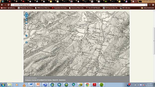
This image
shows a 19th century map of Kiltarlity
that could be incorporated into a
Google Earth also provides an
option to record a narration over tours and I think that this would be a
fantastic way to explain to the viewer what they are seeing, as well as making
the tour a more audio visual experience.
References
http://www.myheritage.com/
http://www.ancestry.com/
http://www.scotlandspeople.gov.uk/
http://visionofbritain.org.uk/maps/