| Title Will Apple Hill Exceed Growth Expectations under Current Zoning Law? | |
|
Author American River College, Geography 350: Data Acquisition in GIS; Fall 2013 Kari Cook, Sacramento, California, (916)548-4635 | |
|
Abstract What once used to be an idyllic, autumn mecca to apple orchards in the Placer area of Northern California is now a growing tourist region. Not only are u-pick orchards and jam and pie shops a seasonal magnet, but established Christmas tree farms and emerging wineries are taking root in the region, and have encouraging residents in the past to demand changes to zoning restrictions. There has been historical dissension between those who want to keep the charm and serenity of the rural area by further restricting zoning criteria and those who would like to join in on the successes of this unique agricultural economy. Tourist maps were georeferenced and shape files for parcels and roads obtained from the County Surveyor's Office. The final analysis identifies parcels eligible to enter the agribusiness under both zoning scenarios. | |
|
Introduction Apple Hill isn't a placename but an area designated by the Apple Hill Growers Association. It consists of a 10-mile stretch just north of Highway 50 beginning east of Placerville centering around Camino and extending to Pollock Pines. What began as 16 ranches in 1964 is now enjoying its 50th year and comprises over 50 ranchers/sellers including tree farms, wineries/breweries and a spa. Every year local residents and farm owners brace themselves or ready their wares, respectively, for the six weeks of chaos that marks the 'season.' However, year-round activities are beginning to become more popular as growers realize the wisdom of stretching the economic calendar. Other seasonal draws include springtime bloom festival for the flower growers, summer ripening for berries, cherries peaches, and nectarines, harvesting grapes for wine, and fall and winter meccas for pumpkins and Christmas trees. These businesses sustain themselves on the $159 million agri-tourist economy and experts says the industry is not yet fully tapped. In 1985, county supervisors rejected a proposal to have agricultural zoning apply only to 20-acre minimum lots capping off a bitter battle between two factions of the Apple Hill Growers Association who have been chasing this issue since 1978. Those proponents of the 20-acre minimum were worried about being able to sustain true agriculturally based farming with just a few acres and wanting to preserve the agricultural integrity of the area. Opponents were concerned about losing their livelihoods since Apple Hill is a great marketing opportunity for the small grower. These small-farm advocates maintain that not every 10-acre parcel has the appropriate slope or soil for zoning. Current congestion problems are causing the County Supervisors to revisit tourism planning in the area. My intention is to evaluate the parcels which would be eligible to assert their rights as a grower based on acreage and zoning under each scenario. | |
|
Background Apple Hill was founded in 1964 after a disease called pear decline destroyed much of the crops in the area. The remaining 16 ranchers formed the Apple Hill Growers Association and began following a new business model known as ranch marketing (selling directly to the consumer) which we now know as farm to fork. Development and growth has become a hot button issue because of the growing desire to further exploit this micro economy or allow residents to enjoy their remaining 46 weeks of rural solitude. The Sacramento Bee and Mountain Democrat report annually on the events and activities taking place. The Apple Growers Association updates their map every year and includes a list of events as well. The El Dorado County Transportation Department has provided public shuttle information to try and encourage visitors to use public transportation to alleviate problems with back-road congestion. |
|
|
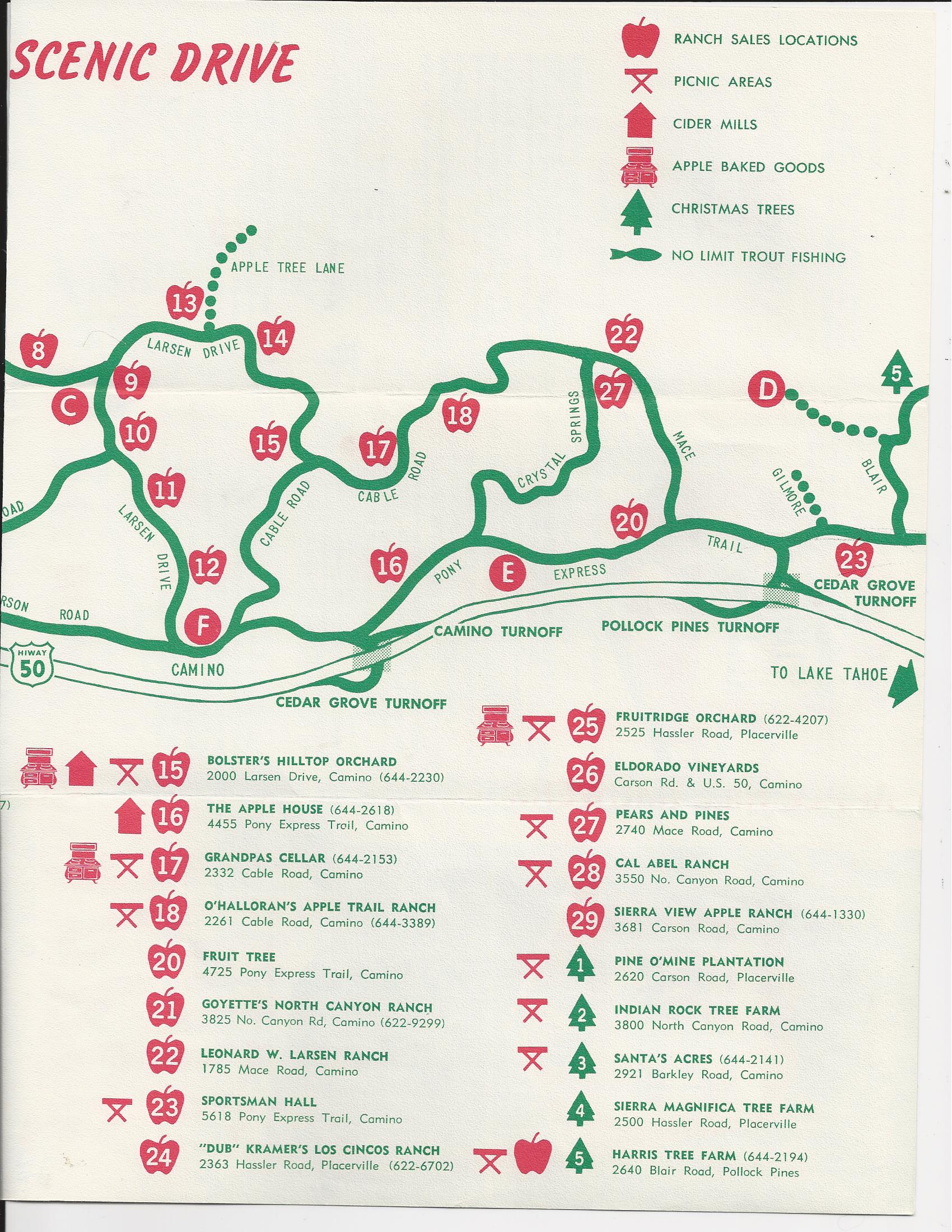
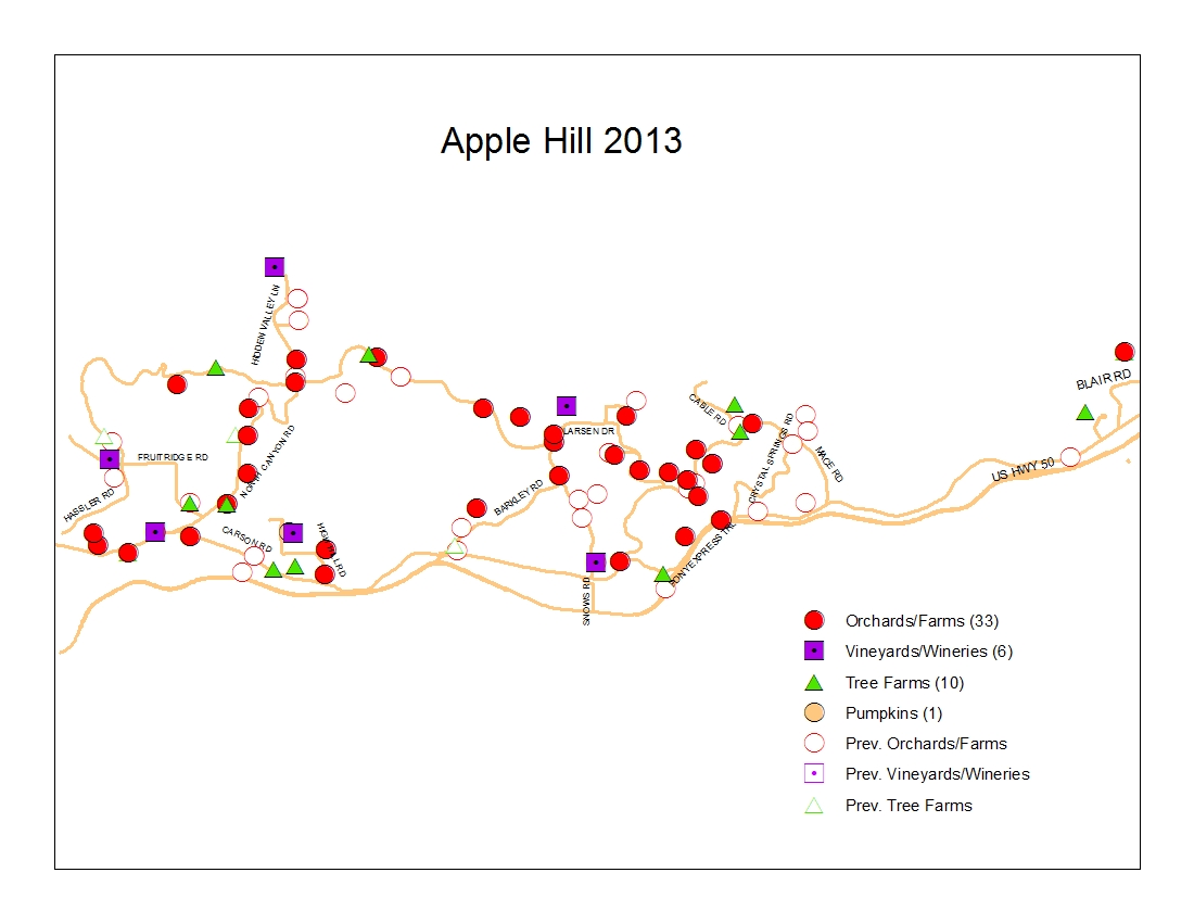
Methods I preliminarily searched the internet for local shapefiles. Other than a few tigerline files and some orthoimagery, very few files exist publicly online (especially those with metadata) for the Camino area. Subsequently, I contacted the El Dorado Surveyor’s office for help with shapefiles. Mr. Jose Crummett GIS Manager with El Dorado County was kind enough to allow me to interview him and browse their file system in person. I was able to download parcel and land use files which wouldn’t have been found elsewhere (Crummett, 2013) I researched farming websites and discovered a treatise on Soil Management for Orchards that cited clay loam as prime orchard soil as well as drainage with high elevation and gentle slopes (Science in Farming, 2013) I contacted the Apple Hill Growers Association via email (info@applehill.com) and was able to obtain scanned historical maps from 1974, 1987, and 1995. The scan quality of the 1987 map was not usable for georeferencing and was similar to enough to the 1974 map to make its use negligible. |
|
| |
|
Results I ended up with 3 point shapefiles of the growers at each point in time. In my map layouts, I incorporated the growers from the previous time periods, but ghosted the symbols for the orchards which no longer exist. Orchards that have changed business names or been sold to others were not depicted separately since the land still bears fruit for commercial purposes. | |
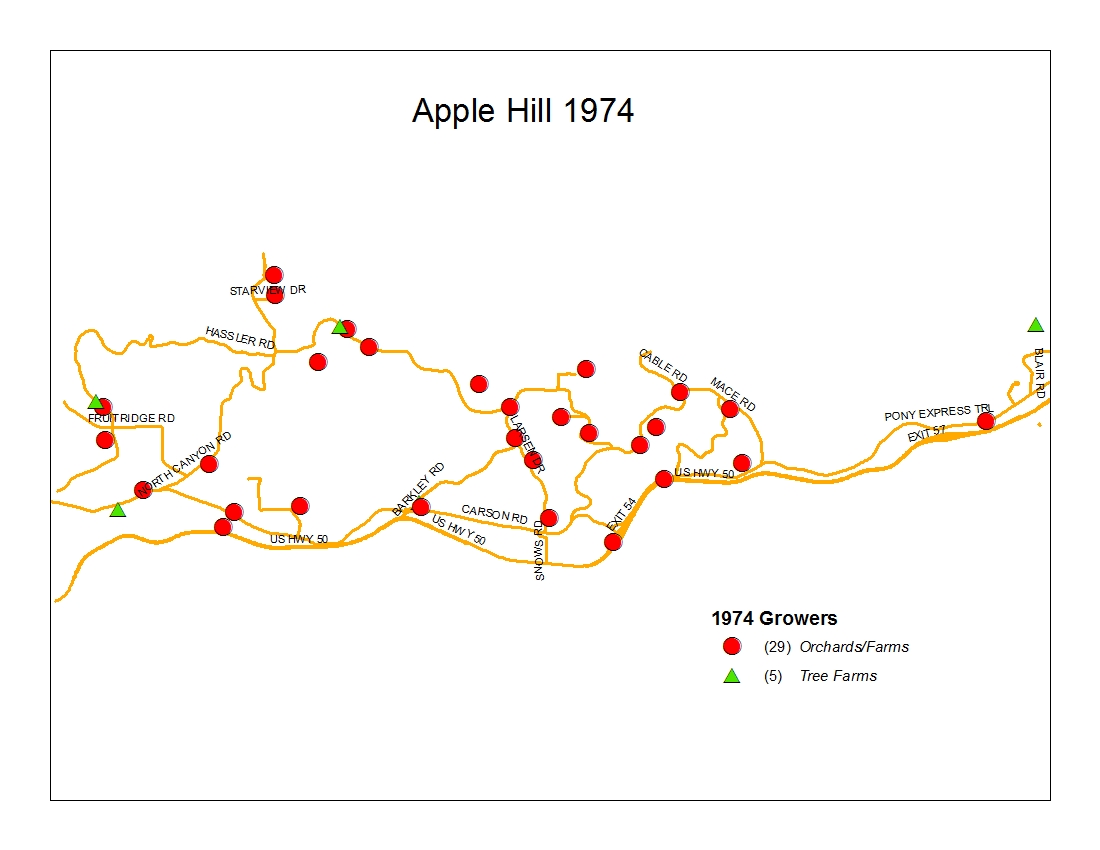 | 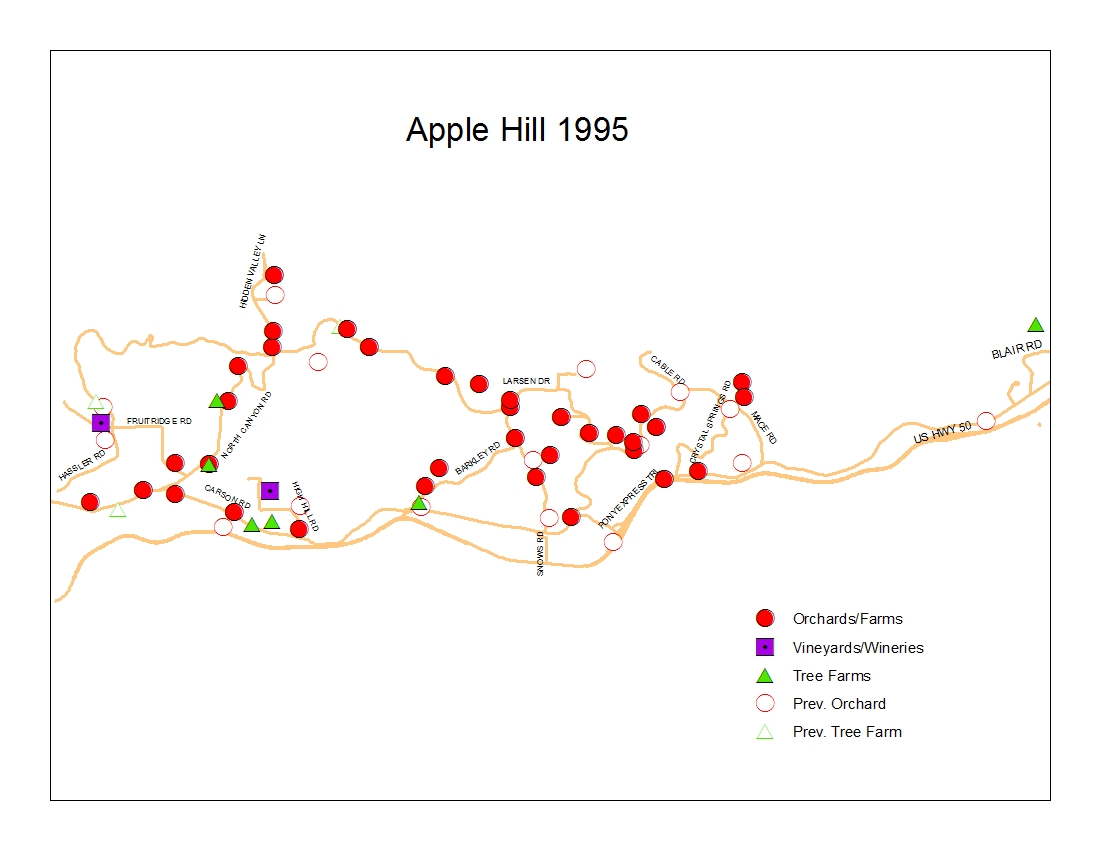 |
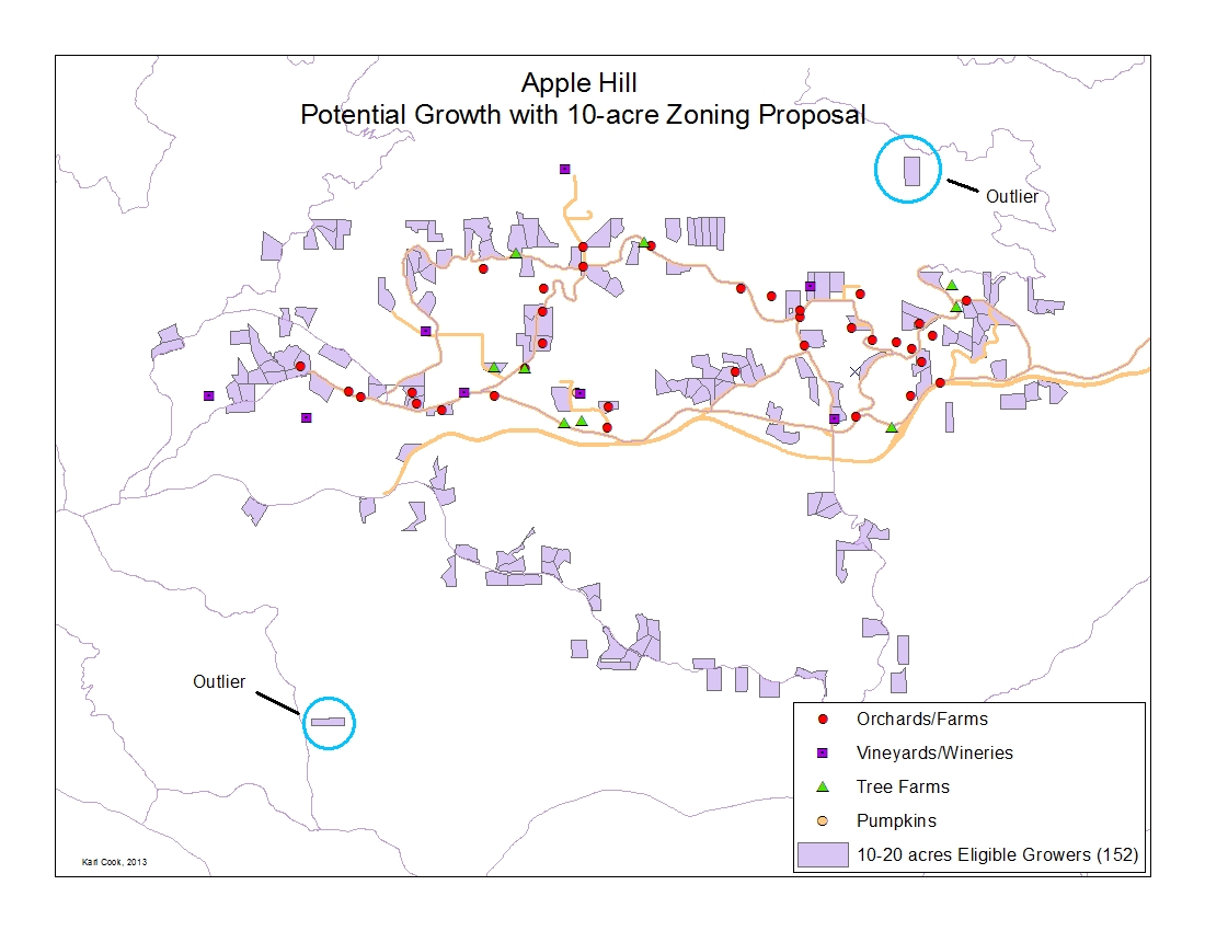
 | I arbitrarily assigned Hi Hill Ranch as the center of Apple Hill. Using that data point as well as the parcel and road maps obtained from the Surveyor's office, I performed 'select by attribute' and 'select by location' to identify parcels with the following characteristics: 1) 4 miles from area center(5,813 parcels) 2) 2 miles from Hwy 50 (4,537 parcels) 3) 1,000 feet from a major road (3,121 parcels) 4) over 10 acres but less than 20 acres in size (241), and 5) Parcels not prohibitively zoned (i.e. commercial, timber preserve, etc.) This left me with 152 parcels potentially able to support an agribusiness venture of which 7 were already assigned as going concerns. |
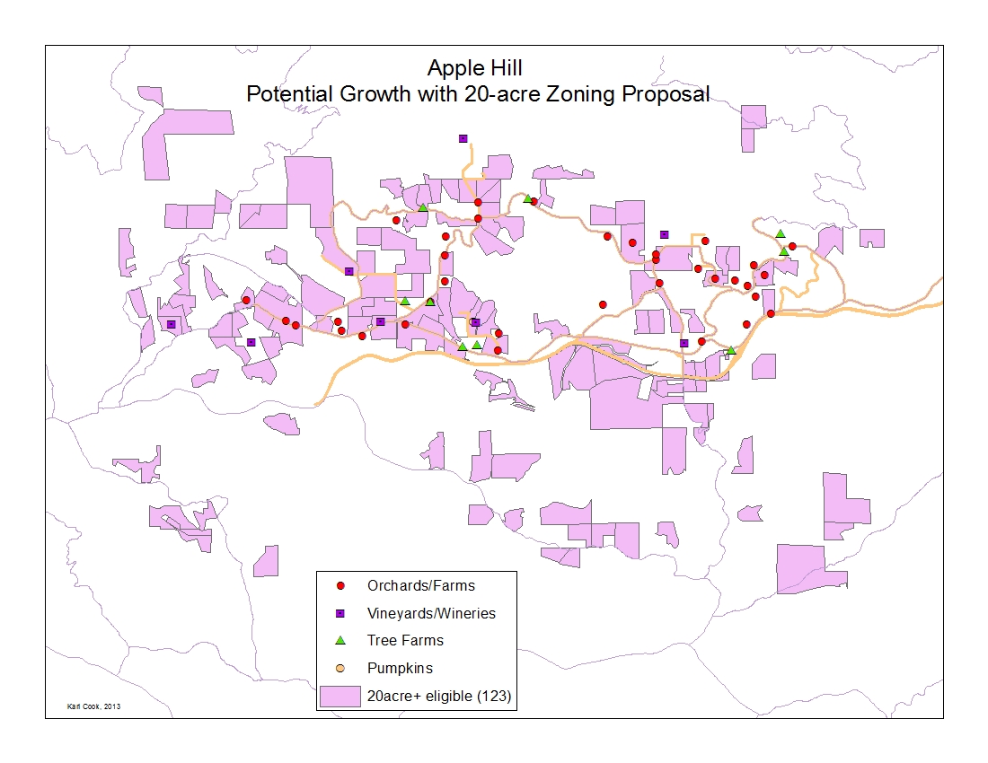
 | I repeated the process using 20 acres in size as the criteria in step 4. This resulted in 123 potential parcels, 27 of which were already going concerns. |
 | |
|
Analysis A control point of 20-acre parcel size may result in slower growth since fewer parcels would eligible under new zoning restrictions.Looking at the maps for each scenario, about half of the identified parcels are south of Highway 50 along Newtown Road and Snows Road which are not currently part of the Apple Hill loop. Additionally, there are outlying parcels on more distant road alignments which when eliminated from the count brought the 10-acre net count to 150 parcels and the 20-acre net count to 66 parcels. Furthermore, soil in those areas south of the highway has lowlands, has been described as rocky loam, and is typically found on steeper, varying terrain. So upon further analysis, we may be able to eliminate many of these 'eligible' parcels for less than optimal growing conditions (Science in Farming, 2013). | |
|
Conclusions Apple growth may be realized within the first 7 or 8 years under normal conditions, 3 years under intensive planting practices and optimal conditions but at a startup cost of $13,000 per acre (Sac Bee, 1992). Also under consideration is that local County code mandates that 5 of the 10 acres must be planted and these figures do not include the yearly cost for maintaining the crops. Further development may tempered by ongoing traffic congestion and safety incidents (Sac Bee, 2013), which may prove the impetus to revisit the zoning issue. Amending the zoning regulation to a 20-acre minimum parcel size would probably also control future growth as other factors would come into play and temper desires to start fledgling roadside stands. But we may not see the difference for the first 3-7 years. | |
|
References Apple Hill Growers Association website, 2013. www.applehill.com, last accessed December 11, 2013. AppleHill Growers Association (Ann Wofford, secretary), file review, December 2013. Batch Geocode website, http://www.findlatitudeandlongitude.com/batch-geocode/, accessed December 11, 2013. El Dorado County Transit Authority, Press Release, September 25, 2008. El Dorado Surveyor's Office, file review with Jose Crummett, GIS Manager, November 15, 2013. El Dorado County Code (draft), revised 10/12/12, Article 4, Section 17.40.260 - Ranch Marketing, last accessed 12.16.13. Rancho Cordova Post, website archive, October 18, 2007. Sacramento Bee, El Dorado Supervisors Reject 20-Acre Minimum Zoning In Camino, March 20, 1984. Sacramento Bee, Apple Hill Turns Sour For Some Who Live There Festival Brings Complaints In Camino, But Most Residents See Economic Gain, October 11, 1984. Sacramento Bee, Reining In Apple Hill Growth Planners Seek Accommodation Between Crowds, Local Residents, December 4, 1986. Sacramento Bee, Apple Hill Goes High Tech, July 5, 1992. Sacramento Bee, Railroad Buffs Want To Revive Regional Rail Line, November 25, 2004. Sacramento Bee, Special Section : The Special Joys of Fall, pages 14-17, October 14, 2013. Sacramento Bee, No More Shuttle at Apple Hill, November 15, 2013. Science in Farming, "Soil Management for Orchards". 2010. non-tables page || index page || || original | |