Title
Coverage of Sacramento Regional Transit
Author Information
Lance Duncan
American River College, Geography 350: Data Acquisition in GIS; Fall 2013
Address:6477 Cedar Ranch Dr. Citrus Heights, CA 95621
phone:916-745-1208
email: wangalade@hotmail.com
Abstract
This paper explores the Sacramento Regional Transit and its capabilty of servicing the greater Sacramento region. This is done by digitizing the bus routes of the Sacramento Regional Transit and creating buffers around the routes in order to see overall coverage of the system. This method is followed four more times for routes that run all day, at night, on saturdays, and on sundays and holidays. It is shown that the Sacramento Regional Transit does provide service for the entire Sacramento area, but does poorly at servicing the area at night or on weekends. It is concluded that adjustments could be made to the routes, or some routes extended later into the night or the weekends. It is also acknowledged that the light rail lines of the Sacramento Regional Transit are not included in this analysis.
Introduction
This project analyzes how well the Sacramento Regional Transit covers the greater Sacramento Area. Most major cities have some form of public transportation, and Sacramento is no different. Sacramento has an extensive bus route system and three light rail lines which supplement the buses. Navigating through the city using the Sacramento Regional Transit can often be challenging, and it seems at times that the Sacramento Regional Transit is not well organized and does not perform well at servicing the area. This project investigates that idea. Does the Scramento Regional Transit service the entire Sacramento area, or is it at fault? To undertake this task it will be neccesary to view a buffer of the routes overlaid on the subect area, and analyze which parts of the sacramento area are serviced and which are not.
Background
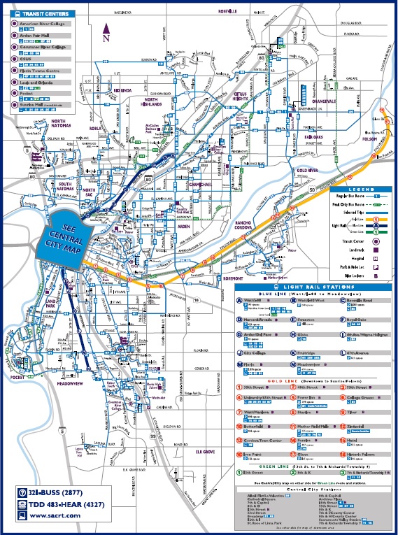
Public transportation, whether it be subway trains, light rail trains, or buses, is an essential part of any major city, but is thought to be more prevalent and organized in European cities and on the east coast of the United States. Often the west coast of the United States is thought to have less well organized and ineffecient public transportation systems. Maps of the sort similar to the London Undergroud Map have been growing in popularity over the last few years in large European and American cities. These maps are more like diagrams than actual maps. Geography is nearly completely ignored, and distances are exxagerated or minimalized in order to make sense of the public transportaion system. Despite the fact that these maps disregard geography, they prove to be invaluable maps for navigating any public transportation system, they create a clearer picture of connections and routes that facillitates the ability to use that public transportation system. The Sacramento Regional Transit is an exception and does not provide a diagram like map, but instead provides an extremely geographically accurate map of its bus routes. This map, which can be found at sacrt.com , is shown below
As can be seen, this map can be very confusing and hard to navigate, and therefore it also proves hard to evaluate the Sacramento Regional Transit. Therefore this project will endeavor to show the overall coverage of the entire system.
Methods
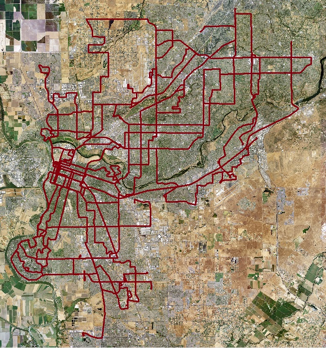
The firt step taken to analyze the Sacramento Regional Transit was to obtain relevant orthoimagery in order to view the areas that were in need of public transportaion service. This imagery was obtained from the NAIP via the national map viewer . Once that imagery was obtained, each bus route of the Sacramento Regional Transit system was digitized into ArcMap along with route information. The result is shown below
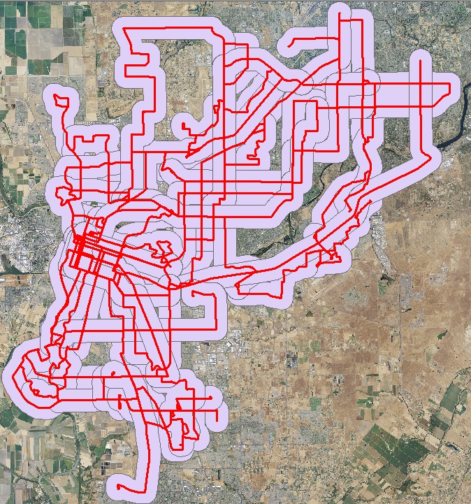
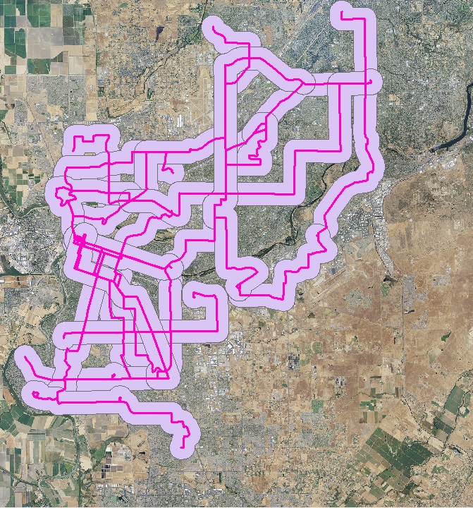
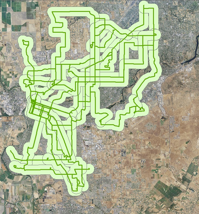
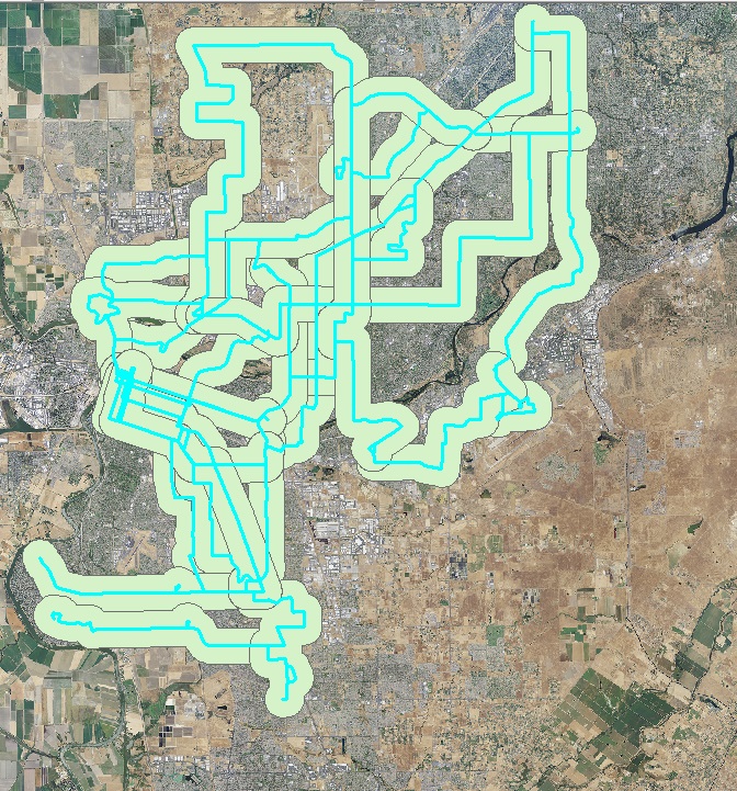
Following this a buffer was created of a 1/2 mile distance to show the areal coverage of the bus routes. The distance 1/2 mile was chosen because that is approximately a 10 or 15 minute walk to any bus route. This was done repeatedly for different types of routes, those that ran during the entire day, those that ran at night, and those that ran on weekends.
Results
The results for the 1/2 mile buffer of the bus routes at peak periods:
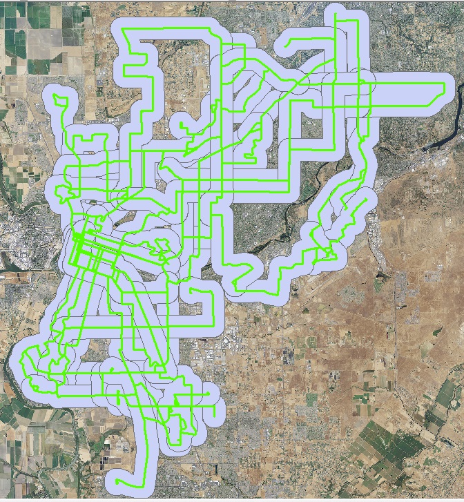
The results for the buffer of routes that ran all day between 8am and 7pm:
The results for the buffer of routes that ran at night after 9pm:
The weekend routes were spilt into two groups, first the routes that ran on saturdays:
and second, the routes that ran on sundays and holidays:
Analysis
Surprisingly, the Sacramento Regional Transit provides complete service to the entire sacramento area, when considering all the bus routes. When considering those routes that run during the day, the area covwered is nearly the same, with the exception of the natomas area. The night routes do a much poorer job of covering the region, there are large gaps and the area in the northwest and in the south is not covered at all. Also it is importatnt to take in consideration that most of the night routes finish between 9pm and 9:20. Only two or three of the night route actually run past 9:30. The saturday routes coverage is similar to the day routes, but with some larger gaps. the sunday and holiday routes are nearly the same as the saturday routes, just with a few routes removed so there are even larger gaps. Overall the system seems to do a good job servicing the entire region.
Conclusion
So in answer to the original question of this project, yes, the Sacramento Regional Transit does service the entire greater sacramento area, albeit not so well at certain times. A resident could successfully travel around the entire Sacramento area using the public transportation system, although if they needed to get somewhere later at night or on the weekend they may need to find another way to get around town or something to supplement the Sacramento Regional Transit. These issues of coverage could be fixed by extending the running time of just two or three more routes into later times of night or weekend routes. Another solution would be to keep the routes running for the same time, but change the routes slightly in order to maximize their coverage. Also it is necessary to remember that the three light rail lines were not included in this analysis.
References
Information on the Sacramento Regional Transit routes and route times were obtained from sacrt.com