| Title Tahoe National Forest Large Fire and Forest Vegetation Relationships | |
|
Author Raymond Hermit American River College, Geography 350: Data Acquisition in GIS; Fall 2013 Contact Information: Address: 449 Marvin Gardens Drive, Vacaville, CA 95687 phone: (707) 455-1762 email: rhermit1@comcast.net | |
|
Abstract The project considers the inter-relationship between large fire dynamics and vegetation types. Forest vegetation types exhibit differences in fuel characteristics that influence the flammability and the severity of wildland fire on the landscape. Forest vegetation is also influenced by various gradients such as elevation, aspect and soil types that determine vegetative productivity and dryness. The result of these dynamics is that fuels determine the potential for fire growth and the resulting fire effects on forest vegetation and fuels. The project analyzes the most recent forest vegetation structure resulting from wildland fires that occurred during the period 1908 through 2011 on the Tahoe National Forest. Forest policies and land management activities have contributed to the formation of landscape patterns that appear in the arrangement and age classes of various plant communities. Active fire suppression and timber harvesting have influenced the structure and function of the different plant communities. It is expected that the size and severity of fires will increase as a result. An assessment of these dynamics may be used test the hypothesis that fire reacts differently in respect to vegetation type. This information could be useful in designing fuel treatment strategies as well as prioritizing projects. Data files of fire perimeter information and vegetation were acquired from the U. S. Forest Service and CalFire. A number of geoprocessing actions were done to prepare the data for analysis. The resulting information was then compiled and summarized creating spreadsheets and graphs. The results of these processes display the fire frequencies of major forest types and fire severity classes for calveg types on the Tahoe National Forest. The results show that there is a strong correlation between large fire fire frequency and strata. There was also a correlation between vegetation type and fire severity classes. The findings suggest a relationship between forest managent and fire suppression policies and current large fire characteristics and resulting fire effects. These factors need additional study and reflection. Additional research is needed to address fuel buildup and the continuing densification and homogenization of landscape and stand conditions | |
|
Introduction The project considers the inter-relationship between large fire dynamics and vegetation types. Fire has been noted as preeminent disturbance on the forest landscape. Forest vegetation types exhibit differences in fuel characteristics that influence the flammability and hence the severity of wildland fire. The fuel amounts and their structure are conditioned over time by disturbances by insects, diseases, wind and snow as well as human activities. Trees, shrubs forbs and grasses produce biomass that will change over time by competition ecological succession thereby increasing fuel amounts. Forest vegetation change in flammability is influenced by the fire environment which is determined by localized fuel conditions, weather, terrain and ignition source and timing. Forest vegetation is also influenced by various gradients such as elevation, aspect and soil types that determine vegetative productivity and dryness. The result of these dynamics is that fuels determine the potential for fire growth and the resulting fire effects on forest vegetation and fuels. The project analyzes the most recent forest vegetation structure resulting from wildland fires that occurred during the period 1908 through 2011 on the Tahoe National Forest. Forest policies and land management activities have also played an integral part in the formation of landscape patterns that constitute the arrangement and age classes of various plant communities. Active fire suppression and timber harvesting are two of the most influential examples. The historic Fire dynamics in the Sierra Nevada interacting with the effects of land management have designed denser forest conditions and homogenized the fuel conditions at landscape scales. It is expected that the size and severity of fires will increase as a result. One way to begin to assess these dynamics is to test the hypothesis that fire reacts differently in respect to vegetation type by determining the fire frequency and fire severity. This information could be useful in designing fuel treatment strategies and assigning prioritization of projects. Future analysis tease out the underlying causation. The project seeks to accomplish this by way of GIS analysis using ArcMap and geo-processing tools. The projects requires the acquisition of a base map layer, forest boundary layer, ownership, a DEM, forest strata and a layer that displays the number of times polygons have burned. Some geo-processing is done to clip layers to the Tahoe National Forest boundary, hillshading is applied to the DEM, and the strata and numfire layers are intersected. The acres are then arrayed by vegetation type and number of times burned. A spreadsheet calculator is created to calculate the frequency of burning per decade and a crude determination of fire severity for each vegetation strata. These factors are then summarized and graphed for comparison purposes. A final report will be written in HTML and a Powerpoint will be created for presentation before the class. A base map of the Tahoe National Forest and surrounding area is displayed in Fig. 1 to provide a spatial context for the project. Fig. 1 Tahoe National Forest 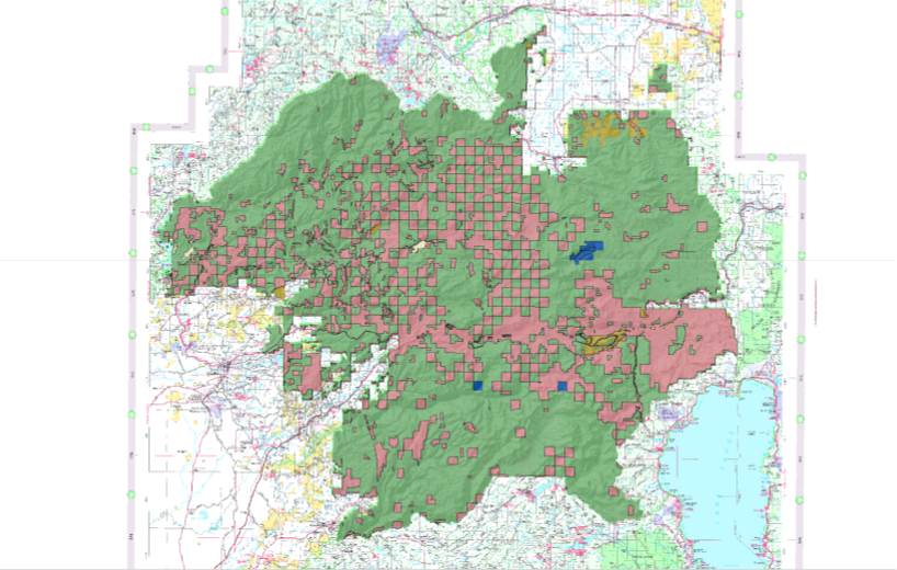
| |
|
Background The Sierra Nevada is a mountain range that covers almost 21 million acres. Nearly two-thirds of the area is managed by government entities. There is a diversity of plant life viewed as forests, woodlands, shrublands, and grasslands.Federal, state and local agencies are tasked with managing the Sierra's to sustain the ecological vitality and at the same time, maintain a flow of goods and surfaces such as timber, water, recreation, and wilderness. Human and natural forces sometimes place these areas at risk. One such disturbance is wildland fire. Wildland fire is a recurrant disturbance in the forests, shrublands, and rangelands of the Sierra Nevada. Once ignited, wildland fires behave in accordance to the laws of chemistry and physics and act on the environment affecting both the types, amounts, and structure of vegetation. Fire also affects how plant communities are arrayed across the landscape over time. Fires also have social and political consequences especially because of the growing migration of urban people along the edges and among wildland environments. Losses of structures and an apparent increase in the number of large damaging fires are portrayed by the media and public officials. It is easy to see why the public views wildfire with concern and seeks to structure policies that would moderate the adverse effects. The Rim fire that consumed over 257,000 acres of the Stanislaus National Forest and Yosemite National Park making it the largest fire in the Sierra Nevada in recorded history. There now appears to be related changes in forest vegetation and types of fire events. A better understanding of the nature of fire behavior, fire ecology, and the affects on the human environment is necessary to formulate prudent land management policies. Fires are influenced by the fire environment which is formed by the composition and structure of fuel, weather and climatic factors, and topography. Fire behavior results from the combustion of fuels and movement of these chemical reactions through time and space. Vegetation, both live and dead, provides the energy source created through photosynthesis. A fuller description of the elements that drive fire behavior and the underlying processes may be found in Countryman(1972), Rothermel(1993), and Pyne((1996). Weather and climate are important factors affecting fire behavior. Relative humidity affects the amount of fuel moisture within the dead and live fuels. Wind affect the direction and velocity of fire spread. Lightning strikes ignite many wildland fires annually. Weather is also instrumental in the establishment and growth of vegetation which becomes fuel. Topography affects fire behavior by directing the flow by the degree and direction of slope, aspect afects fuel moisure and vegetation type. The fire environment and how it influences fire behavior is examined by Countryman(1972) and Pyne(1996). The Sierra Nevada is a mountain range oriented North to South within the confines of California.The westside of the range is affected by a Mediteranean climate where winters tend to be cool and wet and summers that are warm and dry. The eastside of the Sierra Nevada is influenced by a continental high dessert climate which provides for dry cold winters and warm dry summers though the area does experience periodic wet summer monsoon periods. Weather and climate is discussed in greater detail in Schroeder(1970) and Sugihara(2006) Wildland fires are conditioned by their environmental setting which affects the potential intensity of the fires. The energy released by the fire impacts ecosystem constituents that it comes in contact with. The effects of fire on plants is determined by plant structure and plant survival strategies. The Sierra Nevada contains a diversity of plant communities. The plant communities and various vegetation components are formed on environmental gradients such as elevation, slope, aspect, soil substrates, and precipitation. Plant communities also evolve over time as resources such as light, nutrients, and moisture becomes limited. Some plants will die and others will replace them. This competition for the scarce resources leads to a successional pattern of plant communities unless interupted by disturbance such as fire. Fuel loads increase over time, the fuels over the landscape become more homogenized, and the risk of large damaging fires increases. Fires shape the environment especially the vegetation sphere as the vegetation complex helps shape the nature of future fires. Fire ecology is the study of the relationships between fire and the ecosystems. These relationships were noted early in the last century by Leiberg(1902) along with Sudworth, who were sent by the Geologic Survey to Assess the state of forests in the west. They both remarked on the amount and effects of wildland fires. Show(1929) discussed the variability of fires and damage between cover types. A good synthesis of fire ecology is discussed in Pyne(1996) and Sugihara(2006). Skinner(1996) provides a summary of fire ecology and fire regimes in a historical Sierran regional context. Fire has shaped the vegetation on the landscapes of California by each plant's ability to adapt and by each plants flammability characteristics. Plant communities how fires act by determining the fuel characteristics that affect fire spread and intensity. The dynamics that play out as fire and plantcommunities act upon each other over time, determine the arrangement and diversity of plant life over the landscape. How fires become agents for ecological biodiversity is explained by Martin(1991). Fire and plant life are twins in a co-evolutionary process that cycles, but goes through a series of fits and starts as weather fluctuates and other disturbances affect the system. | |
|
Methods Data Acquisition: It was necessary to acquire GIS data layers from the U. S. Forest Service and California Department of Forestry and Fire Protection's Fire and Resource Protection websites to access data required for the fire analysis. These data sets and locations are listed below:
A Base Map was used to provide context for the project area that was to be analyzed. a USGS TOPO Map of the Tahoe area was accessed at the U. S. Forest Service FSGeodata Clearinghouse http://svinetfc4.fs.fed.us/rastergateway/states-regions/states.php A DEM file was obtained at the U. S. Forest Service office, Wildland Fire Training and Conference Center, Fuels/Planning and GIS located at 3237 Peacekeeper Way, McClellan, CA 95652. The DEM is a necessary input for Hillshading the Tahoe National Forest Map in ArcMap. A boundary layer of the Tahoe Nsational Forest was acquired to provide context and use for clipping ldata sets. National Forest Administrative Boundary, http://svinetfc4.fs.fed.us/vector/lsrs.php Tahoe National Forest Strata Data Layer was downloaded from the U. S. Forest Service Pacific Southwest Region Geospatial portal to obtain vegetation cover type data.http://www.fs.usda.gov/detail/r5/landmanagement/resourcemanagement/?cid=stelprdb5350981 and Metadata, http://www.fs.fed.us/r5/rsl/projects/gis/data/tahoe/TnfStrata03_3.html The Tahoe National Forest Frid Data Layer was loaded from the U. S. Forest Service Pacific Southwest Region Geospatial portal for the number of fires data.http://www.fs.fed.us/r5/rsl/clearinghouse/r5gis/frid/ Fire Perimeter Layer was provided from the Department of Forestry and Fire Protection's Fire and Resource Protection for Mapping & GIS Data website, http://frap.fire.ca.gov/data/frapgisdata-sw-fireperimeters_download.php Geoprocessing:A number of geoprocessing actions were performed to prepare the data for analysis. The first operation was to process the DEM file with the ArcMap Hillshade tool to build a shaded relief profile. The DEM was clipped with the masking tool to the Tahoe National Forest administrative boundary. Fig. 2 displays the DEM of California and Fig. 3 shows the Hillshade rendered map of the Tahoe National Forest. Fig. 2 California DEM 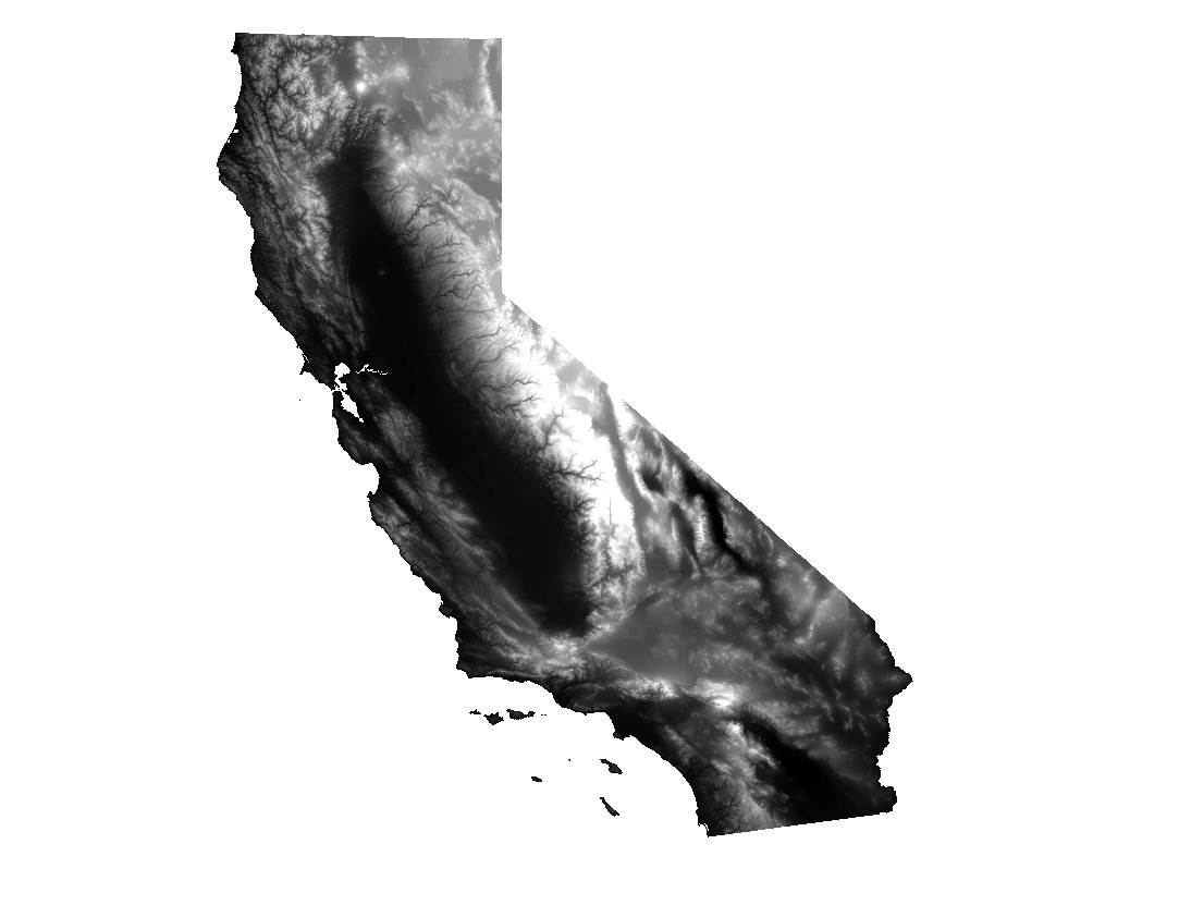
Fig. 3 Tahoe National Forest Hillshade 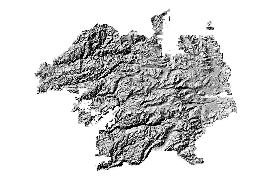
The Tahoe National Forest Strata layer provides the vegetation and forest classification data. The FRID Layer provided an attribute that displays the number of fires each polygon has experienced during the period 1908 - 2011. Analysis of fire effects and fire frequencies by strata classes required that the an intersection of the FRID and Strata layers be completed. Fig. 4 plots the strata types on the Tahoe National Forest. Fig. 5 displays the polygons of the number of fires. Fig. 4 Tahoe National Forest Strata 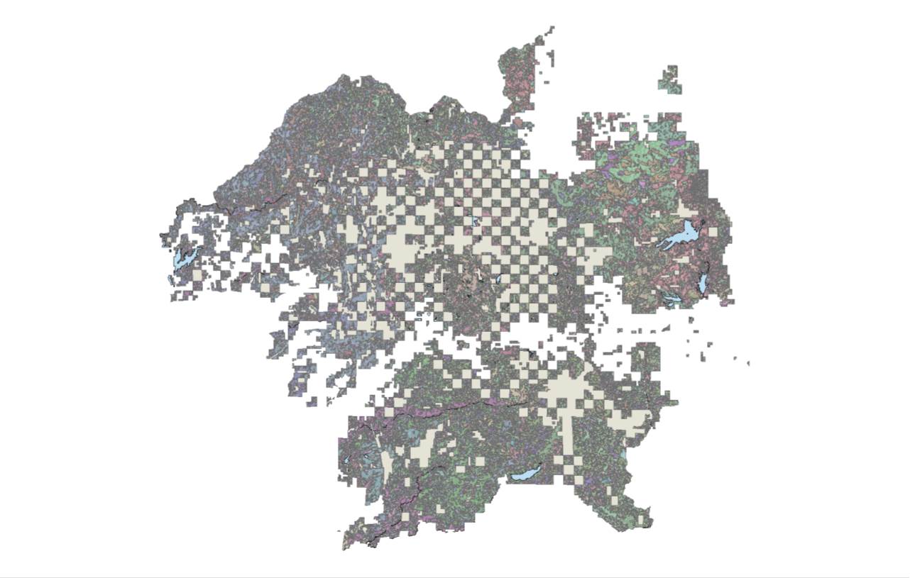
Fig. 5 Tahoe National Forest Number of Fires 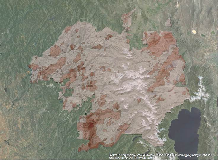
Once the Intersection had been completed, the acres burned in each of the number of fires categories was compiled by strata and listed in a summary table. An Excel spreadsheeet was programed to calculate fire frequency and fire severity for each of the major forest types and for all applicable CalVeg types. An example of one the spreadsheets calculating the fire frequency and fire severity of Ponderosa pine is shown in Fig. 6. Fig. 6 Fire Frequency and Fire Severity Calculator Pine 
| |
|
Results The results from the calculations of fire frequency and fire severity were summarized in a table and then graphed. Fig. 7 displays the fire frequencies of the major forest types. Fig. 8 displays the fire severity classes of each of the major forest types. Fig. 9 graphs the fire frequencies of the other prominent vegetation types located on the Tahoe National Forest Fig. 7 Fire Frequency of Major Forest Types 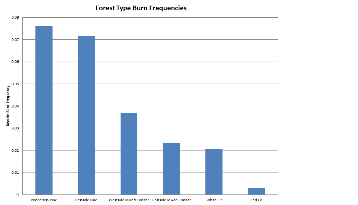
Fig. 8 Fire severity Classes of Major Forest Types 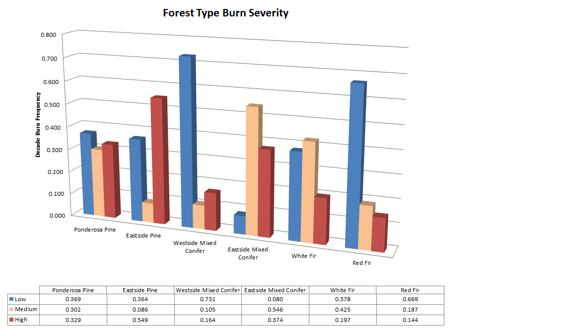
Fig. 9 Fire Frequencies of Other CalVeg Types 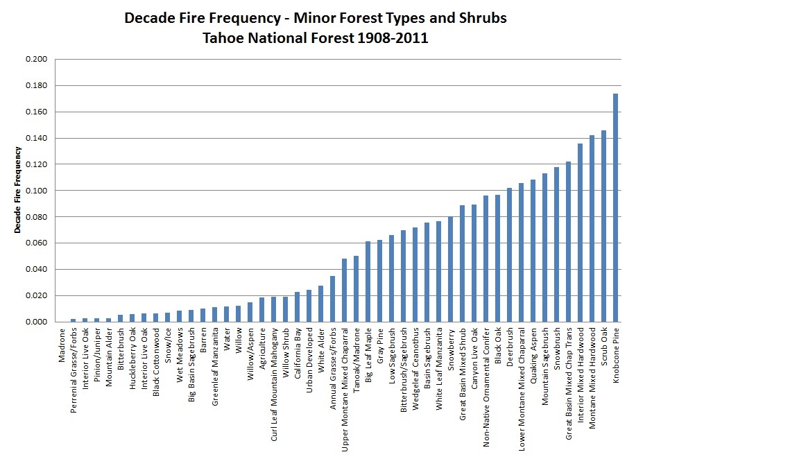
Analysis The results indicated in Graphs 7, 8, and 9 appear to show the following themes. First, there is a strong correlation between large fire fire frequency and strata. The fire frequencies show an increasing rate from high elevation red fir to the Ponderosa Pine and Eastside Pine types. This would appear to show that an elevational gradient is a strong variable in burn frquencies. It is also noted that the strata divisions demonstraing the the fire severity classes also had a strong correlation to fire frequencies. The plantation and younger tree classes had experienced much high burning rates than the mid range classes and finally the older larger and denser stands and this relationship stood for all the major forest types. The fire frequencies for the other CalVeg types followed similar patterns. The fire frequencies were strongly related to elevational gradients and moisture conditions. Vegetation related to riparian ecosystems had lower frequencies than upland species. Westside and Eastside forest types showed some differences in burn rates, but there did not seem as strong a relationship. The eastside burn rates were somewhat less than the westside and this may be due to the lower elevations on the westside and higher productive sites. These productive sites grow more biomass annually which contributes to increasing fuels. The calculations for fire severity provided some results that were unexpected. For instance, eastside pine showed a much smaller amount of the open stands and a larger amount of the larger dense stands. Fire ecology literature recounts the idea of historic fire regimes in pine forests that had frequent fire, low amounts of forest fuels and open stands. The present stand conditions reflect past fire suppression policies and forest management these stand conditions have resulted in increased forest density and fuels. Therefore, there now appears to be greater stand replacement fires as a percentage of the burn severity classes. Another unexpected result is the almost inverse relationship between westside mixed conifer and eastside mixed conifer. This may also be an outcome of fire suppression policies that tried to keep fire out of the system, but have ironically resulted in a buildup of dense forest conditons and heavier fuel loadings. Larger stand replacing fires have occurred as a consequence. | |
|
Conclusions The relationship between large fire frequency and vegetation on the Tahoe National Forest was successfully established. This was accomplished by the combining of data from the NumFire attribute of the FRID database and Strata attributes from a Regional Pacific Southwest Region Vegetation Inventory database. The data was then geoprocessed through ArcMap tools and routines to provide information for analysis. The analysis demontrated strong correlation between fire frequency and vegetation types. There was also a relationship between fire severity and major fire types. The findings suggest a relationship between forest managent and fire suppression policies and current large fire characteristics and resulting fire effects. These factors need additional study and reflection. Additional research is needed to address fuel buildup and the continuing densification and homogenization of landscape and stand conditions on the Tahoe National. Additional studies should be attempted on other National Forests in California to understand if the relationships uncovered on the Tahoe National Forest also exist on the Other Forests. The results of this report can be used as a means to prioritize fuel treatments and stand remedial work to minimize fire sizes and fire effects such as occured during the summer of 2013 on the Tahoe National Forest and Stanislaus National Forest. | |
|
References
Countryman, C.M. 1972. The fire environment concept. Keeley, J.E. 1977. Reproductive Cycles and fire regimes. Pages 231-277 in Proceedings of the Conference on Fire Regime and Ecosystem Properties. GTR-WO-26. Washington DC:USDA Forest Service. Kercher, J.R.:Axelrod, M.C. 1984. Aprocesws model of fire ecology and succession in a mixed-conifer forest. Ecology 65(6):1725-1742. Kilgore, B.M. 1973. The ecological role of fire in Sierran conifer forests: its application to national park management. Quaternary Research 3:496-513
Kilgore, B.M. 1981. Fire in ecosystem distribution and structure:westernforests and scrublands. In Proceedings of the Conference on Fire Regimes and Ecosystem Properties. 11-15 December 1978. Honolulo, HI.(Eds Knight, D.H. 1987. Parasites, lightning, and vegetation mosaic in wilderness landscapes. Pages 59-83 in Turner, M.G. ed. Landscape heterogeneity and disturbance. NewYork: Springer-Verlag. Laacke, R.J.; Fiske, J.N. Sierra Nevada mixed conifers. Pages 44-47 in: Burns, R.M., technical compiler. Silvicultural systems for the major forest types of the United Stated. Agriculture Handbook No. 445. Washington, DC:USDA Forest Service. Leiberg, J.B. 1902. Forest conditions in the northernSierra Nevada, California. Professional Paper No. 8, Series H, Forestry 5. Washington, DC: USDI Geological Survey. Martin, R.E., Sapsis,D.B. 1991. Fires as agents of biodiversity: pyrodiversity promotes biodiversity. In: Harris, R.R.; Erman, D.C. eds. Proceedings of the Symposium on Biodiversity of Northwestern California. Berkeley, CA:University of California, Division of Agriculture and NaturaL Resources Pyne, S.J. 1982. Fire in America:a cultural history of wildland and rural fire. Princeton University Press, Princeton, NJ. 654 p. Pyne, S.J., P.L. Andrews, and R.D Laven. 1996. Introduction to wildland fire. John Wiley and sons, Inc. New York 769 p. Rothermel, R.C. 1983. How to predict the spread and intensity of forest and range fires. Gen. Tech. Rep. INT-143. Ogden, UT: USDA Forest Service, Intermountain Forest and Range Experiment Station. 161 p. Show, S.B.; Kotok, E.I. 1929 Cover type and fire control. in the national forests of California. Department Bulletin No. 1495. Washington, DC:USDA. 35 p. Skinner, C.N. and C. Chang 1996 Fire regimes, past and present. In 'Sierra Nevada Ecosystem Project Final Report to Congress Vol. 2'. (Eds. D.C. Erman) pagesw 1041-1069. University of California Centers for Water and Wildland Resources:Davis, CA. Sugihara, N.G., J.W. van Wagtendonk, K.E. Shaffer, J. Fites-Kaufman, and A.E. Thode(eds). 2006. Fire in California's ecosystems. University of California Press. 596 p. | |
|
Appendices Material may be included in various appendix sections at the student’s option. | |