Title
California Ranchos

Author Information
Andrew Tasabia
American River College, Geography 350: Data Acquisition in GIS; Fall 2013

Abstract
From the early 1820’s until the Gold Rush, Spanish and Mexican rulers granted over 800 large tracts of California land to Spanish, Mexican and white settlers. The rulers did not consider Indian ownership of these lands. Newcomers to California selected valley locations with rich soil and reliable water sources to raise their livestock and crops. Most grants were not accurately surveyed and mapped, which made the claims difficult to prove when California passed into American hands in 1848. With thousands of new immigrants needing land and the owners unable to prove their claims, most of the grants were soon divided into smaller plots. These same land grants of the Spanish and Mexican periods are now the cities, suburbs and agricultural lands of modern California.

Introduction
The purpose of this project is to discover the history and geographic locations of the Mexican Land Grants or Ranchos of California. Many Californians may be somewhat familiar with California missions as they are open for tourism and cover the longitudinal landscape of California. In fact many towns of California are named after the Missions. However, it may be possible that not too many people know of the vast extent of the California Ranchos established during the Spanish and Mexican era that carried beyond to the American era. Also, many towns are named after the ranchos. I myself having been born, raised, and lived in California, it is interesting to me that the names of places I’ve lived over the years have their origins from the era when the Ranchos of California were established. I was born and raised on what use to be Rancho La Puente in Los Angeles County. When I was a young adult, I lived, worked and recreated on many of the ranchos in the Bay Area, and I currently live in what used to be Rancho San Juan in Sacramento County. I’ve also visited and known about the missions of California since the time I was a young boy and have family that were members of the California mission in Ventura. From a land surveyor’s perspective, the relevance of this research pertains to the locations and boundaries of these ranchos which are considered senior to all sectionalized lands in the Public Land Survey System. This is an important point of consideration and part of the process of land surveying in California. [4]

Background
For this project I have selected sources that were readily available through the internet and material acquired through the Geomatics / Surveying program at Sacramento City College as well as information and tools available through ESRI and ArcGIS. Also, for the current topic of study of Geography 350 Data Acquisition in GIS at American River College, I learned to obtain and acquire map data available from outside sources and to use appropriately metadata that should accompany all resourced maps. From this information and tools, I attempted to bring together and create a small window into the past in order to better understand and appreciate California in the present.

Methods
For this project I will discuss the history of California Ranchos and show on maps, developed from ArcGIS, California Ranchos depicted from the Public Land Survey System. I will also focus attention on ranchos of Sacramento County as well as one in particular the Rancho Del Paso to demonstrate how the a California Rancho evolved over time.

Results
Early Years of California
Discovered in 1542, fifty years after Columbus, California was left undisturbed for two hundred and twenty seven years. The world had little knowledge of California. The coast of California was the object of a search for a shortcut to the Orient. Balboa, in 1513, claimed the Pacific shores in the name of the King of Spain. Cabrillo stopped at San Diego in 1542. The Spanish government discontinued exploration of the California area after Viacaino’s voyage in 1603. By 1768 the Spanish government realized the need for colonization if the threat of English and Russians occupying the territory were to be prevented. The Jesuits were removed from control of the missions in Lower California, and in 1767 the Franciscans assumed control. Father Serra established the first mission in Upper California (San Diego) in 1769. [4]

As to the name “California”, there are several theories as to its origin. The one generally accepted is that the name originates from a novel published in Seville in 1510 by Gacia Ordonez de Montalvo called “Las Sergas de Esplandian”. California is described as being on the right hand side of the Indies ruled by Queen Calafia, and abounding in gold and precious stones. [2] In time, this fictional “California” would prove to be close to the reality of what was to become an historical fact. Had the Spaniards known about the gold California was capable of producing? If they were knowledgeable about the gold, were they complacent about it because they already had great success in Mexico and South America? Perhaps they knew about the gold but also were aware it would take much work and perhaps unavailable technology and resources to harvest it.

Along with Mexico, the states of Texas, Arizona, New Mexico, and California made up what was once known as New Spain (see Figure 1).

this is my big green map

Figure 1. Viceroyalty of New Spain after the Adams-Onis Treaty of 1819 (Not including the Spanish overseas territories of the Pacific Ocean) [11]


California was one of the last of the Spanish territories to be occupied. The first Spanish colony to be established in California was the mission and presidio at San Diego in 1769. [2] From this first settlement, the Spanish and Mexican governments founded four presidios, four pueblos, and 21 Catholic missions, along with granting vast amounts of rancho lands to private individuals. [5] The twenty first, and last mission, was founded at Sonoma in 1823, the year after the flag of Spain was replaced by that of Mexico. Under Spain, California was divided into four districts; San Diego, Santa Barbara, Monterey, and San Francisco each with its own presidio. [2] Moreover, it is impossible to relate the story of the Ranchos of California without addressing land distribution in the context of the missions, presidios and pueblos.

Getting colonists to California was not simple. The name did not attract the Spaniard or the Mexican. Many were sent in from jails from Sonora Mexico, and were allowed freedom if they stayed. The pueblos received most of these people. On the other hand, the presidios were populated by soldiers and their families and considered themselves at the top of the social ladder. As to the California Native Americans, they lived in communities called “Rancherias”. It was the mandate of the Padres to bring them to the missions, educate them in religion and prepare them to assume citizenship so that they could obtain title to lands in the vicinities of the missions as individuals. The missions were to be the center of future pueblos. The plan did not succeed however, and they would become little more than pueblo churches. [2] Soldiers and priests disagreed over land ownership. The Franciscans maintained that all land was held in trust for the Indians until such time as they became civilized. The soldiers held that the land belonged to the crown in accordance with the Spanish laws of 1773 and 1786, land could be granted to both the Indians and soldiers. By the time Mexico attained independence in 1821, only 20 private ranches existed in California. [4]

The establishment of four Spanish presidios in California was concurrent with the founding of the missions at the same location. These presidios were military reservations founded for the protection of colonizers and the missions located within the protective radius of influence of these military reservations. [5] A description of these presidios is as follows:

All the presidios were established on the same plan; choosing a favorable place, they surrounded it by a ditch, twelve feet wide and six deep. The earth of the ditch served for the outwork. The enclosure of the presidio was formed by a quadrilateral, about six hundred feet square. The rampart, built of brick, was twelve to fifteen feet high, by three in thickness; small bastions flanked the angles; the presidio had but two gates. Its armament generally consisted of eight bronze cannon, eight, twelve, and sixteen pounders. Although incapable of resisting an attack of ships of war, these fortifications were sufficient to repel the incursions of the Indians. Not far from the presidios, according to the topography of the land, was an open battery (batterie decouverte), pompously styled 'the castle' (castillo).[5]

Within the enclosure of the presidio was the church, the quarters of the officers and soldiers, the houses of colonists, storehouses, workshops, stables, wells and cisterns. Outside were grouped some houses, and at a little distance was the 'King's Farm' (El Rancho Del Rey), which furnished pasturage to the horses and beasts of burden of the garrison. Four coast batteries and four presidios defended “Alta California”: Those of San Diego, founded in 1769; Monterey in 1770; San Francisco in 1776; and Santa Barbara in 1780. [5]


The settlers at the presidios prompted the Spanish government to proclaim the four presidios as pueblos. The commandants of the presidios were the individuals authorized to grant these lands, which were usually measured from the center of the plaza at the presidio. Each of the presidio pueblos were given four leagues (18,164.20 acres, 1 league square = 4,514.05 acres)[4] of land to be parceled out as house lots for building and tilling and grazing land to soldiers and citizens of the Spanish Empire.[5]

Along with the religious plan of establishing missions and the military plan of founding presidios was the civil plan of establishing farming communities in California. These farming communities or pueblos were to be established in fertile valleys in the hope that they would supply the presidios with grain and other staples which, at that time, were being shipped from Mexico. These pueblos were established at San Jose, Los Angeles, Branciforte (Santa Cruz), and Sonoma. They were originally founded as pueblos, differentiating them from the presidios, which eventually became pueblos. The pueblo at Branciforte did not fare well and eventually disappeared and the pueblo at Sonoma was founded by the Mexican Empire after the Mexican revolution. [5]

The four pueblos also acquired four square leagues (18,164.20 acres) of land to be divided into house lots, farm lots, land rented for revenue, commons and pasture lands. The governor of California in 1779 issued detailed instructions for setting up and maintaining the pueblo of Los Angeles. These instructions, which were apparently applicable to the established pueblo of San Jose and any new pueblos, were approved by the Spanish ruler in 1781. The instructions allotted generous pay and food to settlers, free distribution of house lots, farming land, allotment of farm animals, rules for the disposal of property, and the common privileges of water and firewood. Of the eight pueblos established, seven survived to be recognized as such by the United States of America. [5]

When the presidios and pueblos were being established, the commandants of the presidios and the Alcaldes (local judge) of the pueblos were given the authority to grant lots of land within their jurisdiction. From these presidio and pueblo lots evolved the granting of lands outside of these jurisdictions. Spain in “Las Californias”, and after independence, Mexico in “Alta California”, encouraged settlement of the territory by the establishment of large land grants. [2] These grants of land are now known as rancho grants, and were granted in order to encourage agriculture and industry, reward soldiers, and to provide for settlers who held no property. [5] Mostly, the rancho grants were intended for disabled veterans and it was the ex-soldiers who got most of the land. The rancho grants could not encroach upon California Native American Rancherias, or mission concessions, and had to be four leagues (~11 mi) or more from any presidio or pueblo, and the applicant was not supposed to live on the rancho, but in the nearest pueblo or presidio town.

The owners of these ranchos patterned themselves after the landed gentry in Spain. Their workers included California Native Americans who had learned to speak Spanish and to ride horses. Many of the rancho grants ended up devoted to the raising of cattle and sheep. [2]

The rancho grants began in 1784, when Juan Jose Dominguez got permission from Spanish Governor Pedro Fages to put his cattle on the 48,000-acre (190 km2) Rancho San Pedro. The land concessions were usually measured in leagues. A league of land would encompass a square that is one Spanish league on each side – approximately 4,428 acres (18 km2). Of the 800-plus grants, Spain made about 30. The remainder was granted by Mexico. [10]

Spanish Era Concessions
During Spanish rule (1769–1821), the ranchos were concessions from the Spanish crown, permitting settlement and granting grazing rights on specific tracts of land, while retaining title with the crown. During the Spanish period, the population was small and the land was plentiful. But because the title of the land was vested in the crown of Spain, private ownership was not permitted. [2] The Spanish government required the compliance of the following four steps for the concessions:

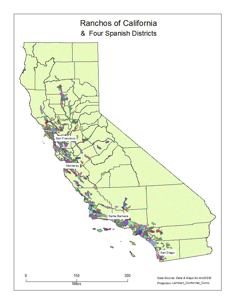
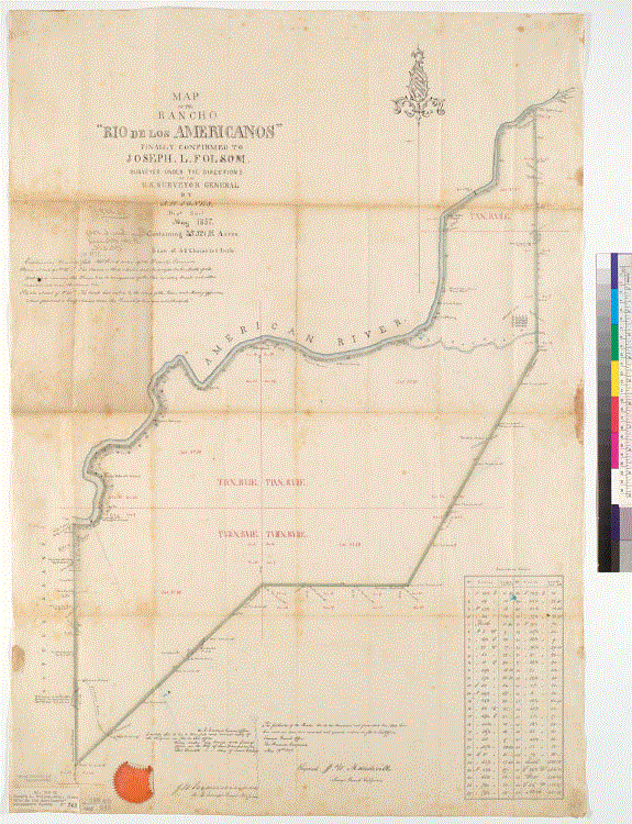
1. The first step was the submitting of a petition by an applicant, containing the name, religion, residence occupation, and the size of the family. Along with a land description and, at times, a 'diseño' – a hand drawn topological map (see Figure 2). The 'diseño' and land description were usually very vague, calling to sloughs, trees, hills, and features which were not very permanent.


this is my big green map

Figure 2. Sketch map or diseño of Rancho Providencia, 1840s. [10]

2. The second step was the inquiries by officials into the availability of the land, the character of the applicant, and the posting of the petition in case another party had objections to the approval of the application.

3. The third step was the ''Informe" which was usually a separate document or a note appended to the original application, stating the findings of the officials in Step Number 2. This third step usually entailed the actual concession of land or refusal of the concession of land.

4. The fourth and final step was the confirmation of the concession by the Viceroy. This final step made the title to the land perfect. The applicant or grantee was given possession by the Alcalde (local judge) who caused the grantee to pull up grass, throw stones, break twigs, and exclaim, "Viva el Presidente y la Nación Mexicana" (long live the President and the Mexican Nation). During the Mexican era, these four steps were also used with minor alterations.[5]


Below is a chronological list of Spanish era concessions. As seen from the list, there were few applications. (Listed chronologically by date of concession)

Concession Date Grantor Grantee Size Location County
1. San Pedro 1784 Pedro Fages Juan Jose Dominguez 48,000 acres (194 km2) San Pedro, Torrance, Redondo Beach, Hermosa Beach, Manhattan Beach, Lomita, Gardena, Harbor City, Wilmington, Carson, Compton Los Angeles
2. Los Nietos 1784 Pedro Fages Manuel Nieto 167,000 acres (676 km2) Long Beach, Lakewood, Downey, Norwalk, Santa Fe Springs, Whittier, Fullerton, Huntington Beach, Seal Beach, Anaheim, Buena Park, Garden Grove, Artesia, Cerritos Orange
3. San Rafael 1784 Pedro Fages José María Verdugo 36,403 acres (147 km2) Atwater Village, Eagle Rock, Glassell Park, Glendale, Highland Park Los Angeles
4. Nuestra Señora del Refugio 1794 José Francisco Ortega 26,529 acres (107 km2) Refugio State Beach Santa Barbara
5. Los Feliz 1795 Pedro Fages Jose Vicente Feliz 6,647 acres (27 km2) Los Angeles, Los Feliz Los Angeles
6. Simi 1795 Diego de Borica Patrico, Miguel, and Francisco Javier Pico 113,009 acres (457 km2) Simi Valley, Moorpark Ventura
7. Buena Vista 1795 Jose Maria Soberanes & Joaquin Castro 8,446 acres (34 km2) Spreckels Monterey
8. Las Salinas 1795 Antonio Aceves and Antonio Romero 17,712 acres (72 km2) Monterey, Salinas Monterey
9. Las Pulgas 1795 Diego de Borica José Dario Argüello 35,000 acres (142 km2) San Mateo, Belmont, San Carlos, Redwood City, Atherton, Menlo Park San Mateo
10. Las Virgenes 1802 José Joaquín de Arrillaga Miguel Ortega 17,760 acres (72 km2) Agoura Hills, Oak Park, Westlake Village Los Angeles
11. El Conejo 1802 Ygnacio Rodriguez and Jose Polanco 48,672 acres (197 km2) Newbury Park, Thousand Oaks, Lake Sherwood, Westlake Village, Oak Park Ventura
12. Topanga Malibu Sequit 1802 José Bartolomé Tapia 13,300 acres (54 km2) Malibu Los Angeles
13. Las Animas 1803 Feliz Berengue Mariano Castro 24,066 acres (97 km2) Gilroy Santa Clara
14. Los Palos Verdes 1809 José Dolores Sepúlveda 31,629 acres (128 km2) Part of Rancho San Pedro Los Angeles
15. San Ysidro 1809 José Joaquín de Arrillaga Ygnacio Ortega 13,066 acres (53 km2) Gilroy Santa Clara
16. San Antonio 1810 Antonio María Lugo 29,513 acres (119 km2) Bell, Bell Gardens, Commerce, Cudahy, East Los Angeles, Lynwood, Montebello, South Gate, Vernon Los Angeles
17. Santiago de Santa Ana 1810 José Antonio Yorba & Juan Pablo Peralta (Nephew) 63,414 acres (257 km2) Santa Ana, El Modena, Orange, Irvine, Costa Mesa, Tustin, Olive. Orange
18. La Ballona 1819 Machado and Talamantes families 13,920 acres (56 km2) Culver City, Inglewood, Marina del Rey, Palms, Playa del Rey, Santa Monica (Ocean Park Dist), Venice Los Angeles
19. San Antonio 1820 Pablo Vicente de Solá Luís María Peralta 44,800 acres (181 km2) Albany, Alameda, Berkeley, Emeryville, Oakland, Piedmont, San Leandro Alameda
20. Rincon de los Bueyes 1821 Pablo Vicente de Solá Bernardo Higuera and Cornelio Lopez 3,127 acres (13 km2) Cheviot Hills, Rancho Park, Culver City, Baldwin Hills Los Angeles
21. Vega del Rio del Pajaro 1821 Pablo Vicente de Solá Antonio Maria Castro 4,310 acres (17 km2) Monterey, Watsonville Monterey
22. Los Tularcitos 1821 Pablo Vicente de Solá José Higuera 4,394 acres (18 km2) Milpitas Santa Clara
23. Sausal Redondo 1821 Antonio Ygnacio Avila 22,458 acres (91 km2) Manhattan Beach, Lawndale Beach, Hermosa Beach Los Angeles

Mexican Era Grants
It was not until the Mexican era (1821–1846) that the land was actually granted to individuals. In 1821, Mexico achieved its independence from Spain, and California came under control of the Mexican government. The 1824 Mexican Colony Law established rules for petitioning for land grants in California; and by 1828, the rules for establishing land grants were codified in the Mexican Reglamento (Regulation). The Mexican Governors of Alta California gained the power to grant state lands, and many of the Spanish concessions were subsequently patented under Mexican law. [10] However, under the newly established Mexican government there was not a great rush to obtain grants. [2]

Through the Secularization Act of 1833, the Mexican government repossessed most of the lands that had been provided to the missions by the Spanish crown. Secularization was implemented between 1834 and 1836. The Acts sought to break the monopoly of the missions and also pave the way for settlers to California by making land grants easier to obtain. The padres could only keep the church, priest's quarters and priest's garden. A commissioner would oversee the crops and herds, while the land was divided up as communal pasture, a town plot, and individual plots for each California Native American family. [10]

Many holders of Spanish concessions applied for grants to insure their stake, and any citizen, whether foreign born or native could select a tract of unoccupied land. A petition was prepared, usually accompanied by a 'diseño' and presented to the governor. After investigation, and receiving no objection from any source, and satisfied with the petitioner’s qualifications, the governor wrote on the margin of the petition “let the title issue”. A grant was then written, signed by the governor and delivered to the grantee, and after a formality involving an Alcalde, the new owner took possession of his grant. The entire transaction cost about twelve dollars. [2]

The size of the rancho grant was indicated as so many leagues “more or less”. Smaller plots were surveyed with a fifty foot reata from the saddle, starting from a “mojonera”, a pile of stones or earth with a cross on it as a landmark. The rancho grants were limited in size to a maximum of eleven leagues (49,654 acres), most were smaller and a few were larger. The ranchos covered some of the most fertile land in the state and the raising of cattle was very much the way of life. There were few in the world that could surpass the ranchero and his vaquero in horsemanship. At the age of four or five the boys were placed in the saddle. The girls also rode. There were few who could not ride well. However, the land holdings of a person, whether large or small was no measure of wealth. Wealth was only counted in cattle. The cattle, originally brought from Mexico, eventually increased to such an extent that many were allowed to roam the San Joaquin and Sacramento valleys in a state of wildness. [2]

California Land Grants Made by Spanish or Mexican Authorities
Under Mexican rule land grants became frequent to those held in favor, and, during the early era, no records other than brief notes were kept. Who owned what was simply a matter of public knowledge. During the Mexican era many U.S. citizens moved into California, especially sea going men. By claiming Mexican citizenship and proclaiming themselves Catholics, some obtained land grants. By the end of the Mexican era (26 years), in 1847, the number of land grants in California had increased from 20 to 800, a number of these grants were made by Governor Pio Pico in the last days of his reign. [4]

Below is a map of California land grants made by Spanish or Mexican authorities, before California became part of the US to private individuals and later surveyed and confirmed in the American era. [1] This map of California land grants is represented by unique color values in ArcGIS. The map also displays the counties of California and names four districts established during the Spanish Era.

Map of Ranchos of California & Four Spanish Districts by Andrew Tasabia
this is my big green map

U.S. Conquest
The United States declared war against Mexico on May 13, 1846. Action in California began with the Bear Flag Revolt on June 15, 1846. The authority and jurisdiction of Mexican officials terminated on July 7, 1846, the day the forces of the United States took possession of Monterey, the capital of California. Armed resistance ended in California with the Treaty of Cahuenga signed on January 13, 1847. The Treaty of Guadalupe Hidalgo, ending the war, was signed February 2, 1848 and California became a Territory of the United States. Between 1847 and 1849, California was run by the U.S. military. A constitutional convention met in Monterey in September 1849, and set up a state government that operated for 10 months before California was admitted to the Union as the 31st State by Congress as part of the Compromise of 1850, enacted on September 9, 1850. [10]

The Treaty of Guadalupe Hildalgo was the basis for establishing the rights of Mexicans to land title within the conquered territories. Within Article VIII of the treaty, the following is stated, "In the said territories, property of every kind, now belonging to Mexicans not established there, shall be inviolably respected. The present owners, the heirs and all Mexicans who may hereafter acquire said property by contract shall enjoy ample as if the same belonged to citizens of the United States." [5]

While the end of the 1840s saw the close of Mexican control over California, this period also marked the beginning of the rancheros’ greatest prosperity. Cattle had been raised primarily for their hides and for the tallow, as there was no market for large quantities of beef. This dramatically changed with the Gold Rush as thousands of miners and other fortune seekers flooded into northern California. These newcomers had to be fed and cattle prices soared and the rancheros enjoyed the halcyon days of Hispanic California. [10]

Land Claims
The process of land confirmation of private land claims by the United States was tenuous. Arguments against the process have been submitted by historians and scholars. The most persistent argument being the criticizing of the undue hardships applicants endured in order to receive confirmation to land already owned. In retrospect, the confirmation of the private grants could have been made easier and less expensive, for the landowners. The burden of proof was placed onto the Mexicans and naturalized citizens of conquered Mexico. [5]

The Treaty of Guadalupe Hidalgo provided that the Mexican land grants would be honored. In order to investigate and confirm titles in California, American officials acquired the provincial records of the Spanish and Mexican governments in Monterey. [10] Sponsored by California Senator William M. Gwinm and in order to implement the confirmation of these land titles, the Congress of the United States on March 3, 1851, established the Board of Land Commissioners, by virtue of an Act entitled, "An Act to Ascertain and Settle Private Land Claims in the State of California, (U.S. Stats.at large, Volume 9, page 631). [5]

The Act required all holders of Spanish and Mexican land to present their title for confirmation before the Board of California Land Commissioners. Contrary to the Treaty of Guadalupe Hidalgo, this Act placed the burden of proof of title on landholders. While these procedures discouraged the filing of fraudulent claims, the valid claims were encumbered by costly lawyers, the difficulty of finding absolute proof of ownership and the different laws, customs, and languages involved. [10]. After confirmation by the Commissioners, appeals to the District Court, and Supreme Court, were argued until the Commissioner's confirmation was upheld or reversed. Once confirmed by the courts, a survey of the land was performed. [5]

Often the land grants had been made without closely defining the exact boundaries. In cases where the boundaries were more specific, many markers had been destroyed before accurate surveys could be made. Aside from indefinite survey lines, the Land Commission had to determine whether or not the grantees had fulfilled the requirements of the Mexican colonization laws. Sometimes, either because of objections by adjacent landowners or because of discrepancies within the survey more than one survey was needed.

The survey costs were at the expense of the claimant. When these survey costs were paid and the survey advertised in the newspaper, per the Act of Congress approved July 1, 1864, the applicant could then petition the General Land Office for a final patent. [5]

The Board of Land Commissioners tenure was extended to five years and the Board adjourned on March 1, 1856. In these five years, 813 cases involving private land claims were heard by the Commission; 604 claims were confirmed; 190 rejected; and the rest were withdrawn. Of these 813 cases, only three were decided by the Board; the rest were appealed to the District Court and then a significant number of these were finally decided by the Supreme Court. Again, the cost of this litigation and confirming process was charged to the applicant. [5]

Because of the time and money involved, the original grantee was sometimes forced to sell the property. In some cases, the individual who eventually received the final patent was not the original petitioner. [5] The rancheros were land rich and cash poor, and the burden of attempting to defend their claims was often financially overwhelming. Land passed from the grantees as a result of mortgage default, in payment of attorney fees or for other personal debts owed; and land was lost also as a result of fraud. Combined with a sharp decline of cattle prices, the floods of 1861–1862, and droughts of 1863–1864, forced many of the over-extended rancheros to sell their properties to Americans who often quickly subdivided the land and sold it to new settlers who came to California and began farming. [10]

A further shift in economic dominance from cattle ranching to grain farming was marked by the passage of the California "No-Fence Law" in 1874. This was actually the repeal of the Trespass Act of 1850, which had required farmers to protect their planted fields from free-ranging cattle. The repeal of the Act required that the rancher fence his stock in, rather than the farmer fence them out. The ranchers were faced with either the enormous expense of fencing large grazing tracts or selling their cattle at ruinous prices. [10]

Added to the difficulties of confirmation was the time involved for the landowners to receive a final patent to their land. The average length of time for a final patent to be issued, after the filing of an original petition, was seventeen years (with American Civil War, 1861–1865) to resolve, some took as long as, thirty-five to forty years. [10]

Land from titles not confirmed became part of the public domain and available for homesteaders, who could claim up to 160-acre (0.65 km2) plots in accordance with federal homestead law of 1862. Rejected land claims resulted in claimants, squatters, and settlers pressing Congress to change the rules. Beginning with Rancho Suscol in 1863, special acts of Congress were passed that allowed certain claimants to pre-empt their land – without regard to acreage. By 1866 this privilege was extended to all owners of rejected claims. [10] When California was admitted as a state in 1850, the US District Court California was divided into two districts, the Northern and the Southern. [10]

Land Claims: Missions
The beginning of the end for the missions began with secularization in 1834, and by the time the American flag was raised in 1846, some were sold into private hands and the rest were in various states of decay. [2] The Board of Land Commissioners regarded these missions as private land claims and at the time of the confirmation hearings were subjected to the same process of confirmation and patenting as rancho lands. [5]

During the confirmation arguments, a distinction was made between the terms "mission" and "mission lands." The term "mission" was used only to include the collection of houses, vineyards and orchards in the immediate vicinity of the churches including the stock of cattle and other personal property in the possession of the priests, and useful and necessary in carrying on the missions. The term "mission lands" being the lands adjacent and appurtenant to the missions used by them for grazing purposes, and occupied only by permission, were the property of the nation and subject at all times to grant under the colonization laws of Spain. [5]

The Board refused to grant "mission lands" in their confirmation procedures; consequently, the land eventually granted to the missions was far less than they had petitioned for. Archbishop Joseph Sadoc Alemany, acting on behalf of the Roman Catholic Church, filed 21 petitions for confirmation of missions on February 19, 1853. These 21 missions, which were all confirmed and patented, are listed below, beginning with the southernmost one at San Diego and going north. [5]

1. Mission San Diego, in San Diego County, founded under Carlos III, July 16, 1769; containing 22.21 acres. Patented May 23, 1862.
2. Mission San Luis Rey, in San Diego County, founded under Carlos IV, June 13, 1798; containing 53.39 acres. Patented March 3, 1865.
3. Mission San Juan Capistrano, in Orange County, founded under Carlos III, November 10, 1776; containing 44.40 acres. Patented March 18, 1865.
4. Mission San Gabriel Arcangel, in Los Angeles County, founded under Carlos III, September 8, 1771; containing 190.69 acres. Patented November 19, 1859.
5. Mission San Fernando, in Los Angeles County, founded under Carlos IV, September 8, 1797; containing 76.94 acres. Patented May 31, 1864.
6. Mission San Buenaventura, in Ventura County, founded under Carlos III, March 31, 1782; containing 36.27 acres. Patented May 23, 1862.
7. Mission Santa Barbara, in Santa Barbara County, founded under Carlos III, December 4, 1786; containing 283.13 acres. Patented March 18, 1865.
8. Mission Santa Inez, in Santa Barbara County, founded Carlos IV, September 17, 1804; containing 17.34 acres. Patented May 23, 1862.
9. Mission La Purisima Concepcion, in Santa Barbara County, founded under Carlos III, December 8, 1787; containing 14.04 acres. Patented January 24, 1874.
10. Mission San Luis Obispo, in San Luis Obispo County, founded under Carlos III, September 1, 1772; containing 52.72 acres. Patented September 2, 1859.
11. Mission San Miguel Arcangel, in San Luis Obispo County, founded under Carlos IV, July 25, 1797; containing 33.97 acres. Patented September 2, 1859.
12. Mission San Antonio de Padua, in San Luis Obispo County, founded under Carlos III, July 14, 1771; containing 33.19 acres. Patented May 31, 1862.
13. Mission La Soledad, in Monterey County, founded under Carlos IV, October 9, 1791; containing 34.47 acres. Patented November 19, 1859.
14. Mission El Carme or San Carlos de Monterey, in Monterey County, founded under Carlos III, June 3, 1770; containing 9 acres. Patented October 19, 1859.
15. Mission San Juan Bautista, in San Benito County, founded under Carlos IV, June 24, 1797; containing 55.23 acres. Patented November 19, 1859.
16. Mission Santa Cruz, in Santa Cruz County, founded under Carlos IV, August 28, 1791; containing 16.94 acres. Patented September 2, 1859.
17. Mission Santa Clara, in Santa Clara County, founded under Carlos III, January 18, 1777; containing 19.95 acres. Patented March 3, 1858.
18. Mission San Jose, in Alameda County, founded under Carlos IV. June 22, 1797; containing 28.33 acres. Patented.
19. Mission Dolores or San Francisco de Assisi, in San Francisco County, founded under Carlos III, October 9, 1776; two lots, one containing 4.03 acres and the other 4.51 acres. Patented March 3, 1858.
20. Mission San Rafael Arcangel, in Marin County, founded under Fernando VII, December 18, 1817: containing 6.48 acres. Patented October 19, 1859.
21. Mission San Francisco Solano, in Sonoma County, founded under Fernando VII, August 25, 1813; containing 14.20 acres. Patented May 31,1862.


Land Claims: Pueblos
The Board of Land Commissioners regarded pueblos as private land grants and required them to submit petitions for confirmation. During these confirmation hearings, an argument arose as to the historical authenticity of the Spanish grant of four leagues of land to these pueblos. The argument contended that no paper title for some of the pueblo grants was found or ever existed, so, consequently, some pueblos were not entitled to the four square leagues. This contention was challenged by the City of San Francisco. During its appeal, the city stated that no such paper or parchment grant ever existed. It was enough that every Pueblo, when it reached a certain state of development, became ipso facto, entitled to certain rights in land. It is enough that development was attained by the Pueblo of San Francisco and was officially conceded to exist by the Spanish government and its rights in its pueblo lands recognized. When special corporations are created by a general statute, their general powers are not enumerated, but they obtain them from the general act. So the laws of Spain and Mexico have declared from time immemorial that "every fully organized Pueblo, as such, shall be entitled to four square leagues of land". [5]

This argument was resolved in favor of the pueblos and the four-league grant. Once resolved, the question of how these four leagues were to be partitioned was raised. Some proponents suggested four leagues square from the center of the pueblo, in each cardinal direction, making a total of 64 square leagues. Others argued that it meant four leagues squared or 16 square leagues. These arguments were put aside by the courts and four square leagues total was established as the extent of the pueblo lands. Each of the seven pueblos were finally confirmed and patented. However, because of encroachments by rancho grants or other circumstances, not all the pueblos received the four square leagues. [5]

The patent date and the area received by the Pueblos are listed below, beginning with the southernmost at San Diego and going north.

1. Presidio of San Diego in San Diego County, founded July 16, 1769: patented April 10, 1874 to the City of San Diego; containing 47,323.08 acres.
2. Pueblo of Los Angeles in Los Angeles County, founded in 1781; patented August 4. 1875 to the City of Los Angeles; containing 17,172.37 acres.
3. Pueblo of San Jose in Santa Clara County, founded in 1777; patented July 4, 1884 to the City of San Jose; containing 55,891.77 acres.
4. Presidio of Monterey in Monterey County, founded June 3, 1770; patented November 19, 1891 to the City of Monterey; containing 29,698.53 acres.
5. Presidio of Santa Barbara in Santa Barbara County, founded April 19, 1782; containing 17,826.17 acres; patented June 31, 1872 to the City of Santa Barbara.
6. Presidio of San Francisco in San Francisco County, founded on September 17, 1776; patented June 20, 1884 to the City of San Francisco; containing 17,754.36 acres.
7. Pueblo of Sonoma in Sonoma County, founded in 1835 by the Mexican government; patented March 31, 1880 to the City of Sonoma; containing 6,063.95 acres.


A Little History of Rancho Del Paso

The following account is credited to Lance Armstrong of the Valley Community Newspapers published on April 28 2011 in an article named “Rancho Del Paso included future Arden, Carmichael Areas”. [1]

Known as Rancho Del Paso (“Ranch of the Pass”), this grant was roughly located within the modern boundaries of Northgate Boulevard to the west, the American River to the south, Manzanita Avenue to the east and a little south of Elverta Road in the vicinity of U Street to the north.

In being that Rancho Del Paso did not extend to the east beyond the present day Manzanita Avenue and a parallel route from this avenue to the river, the more eastern part of Carmichael lies within the site of another historic Mexican land grant, which was known as Rancho San Juan. Today, the Rancho Del Paso acreage includes such notable sites as Town and Country Village, Del Paso Country Club, Arden Fair Mall, Country Club Plaza, Loehmann’s Plaza and McClellan Field.

The property that became the Rancho Del Paso land grant did not appear in recorded history until 1839 with the arrival of Captain John A. Sutter. Sutter, who held the rights to the Mexican land grant, New Helvetia, where Sutter’s Fort was constructed and the city of Sacramento was later founded, also claimed rights to Rancho Del Paso. Four years after acquiring New Helvetia, Sutter deeded Rancho Del Paso to Eliab Grimes, Hiram Grimes and John Sinclair as a possible payment for supplies. Rancho Del Paso Historical Society President Bob Kent said that Sutter did not actually own the land that he deeded to these three men.

“John Sutter deeded a big hunk of land to two guys named Grimes and John Sinclair,” Kent said. “Sutter probably owed these men money, because he worked on credit and these were guys who had money. Except Sutter didn’t own the property. Later on, (Sutter) was granted a second grant that went way up into Marysville, called the Sobrante grant. The Sobrante grant came a few months after (John Sinclair and the Grimeses were deeded Rancho Del Paso), so (Sutter) may have anticipated that he was going to get the (Sobrante grant) and he decided to give them a hunk of it to settle some credit claims.”

John Sinclair, who was a native of Scotland, settled on the rancho, which was named after a ford in the river, with his wife, Mary, and began raising cattle, sheep and hogs. Kent said that John and Mary Sinclair had children together and resided “down by the pass in the river,” near today’s H Street Bridge. “(John and Mary Sinclair) had a little family and they had a nice place,” Kent said. “It was reported that their ranch house was of the Eastern style, which means that it was made from lumber.”

Desiring a better title to this land Eliab, who was a naturalized Mexican citizen, petitioned the Mexican government, which on Dec. 20, 1844 responded by making Rancho Del Paso an official Mexican land grant. According to research by former McClellan Air Force Base historian Raymond Oliver, John Sinclair and Eliab Grimes held rodeos on the ranch on May 29, 1847 and on Nov. 5, 1847.

Eliab passed away at the age of 69 on Nov. 11, 1848 and according to the Nov. 18, 1858 edition of The Sacramento Union, he had willed “all his right, title and interest in the land embraced in the grant” to Hiram, who was his nephew.

Rancho Del Paso was sold to Samuel Norris on Aug. 8, 1849, and Hiram later acquired the 19,982-acre Rancho San Juan, which was located on the north side of the American River, opposite the Leidesdorff Rancho. This latter land transfer occurred in July 1860. Norris, who was born Gotthilf Wilhelm Becher Christensen, in Denmark in 1822, had met the Grimeses and John Sinclair in the Sandwich Islands (present day Hawaii), where they had lived for some time prior to coming to California.

The Placer Times reported on March 9, 1850 that in addition to owning Rancho Del Paso, Norris was in the process of establishing his own town, “Norristown.” Founded near his ranch on the south bank of the American River in the area where Sacramento State University is now located, the town, which was renamed Hoboken, functioned in its civic capacity for at least three years.

James Ben Ali Haggin and his brother-in-law Lloyd Tevis became the new owners of Rancho Del Paso in 1862, and Norris returned to the Sandwich Islands.

Haggin, who arrived in California from Kentucky at the age of 29 in 1850, was the most renowned owner of the property. The rancho remained under the ownership of Haggin and Tevis until 1869, when Rancho del Paso was transferred to the Sacramento Farm Homestead Association, whose trustees included former California Gov. Leland Stanford and the well-known banker D.O. Mills. The association had intended to subdivide and sell the property, but this endeavor failed, apparently due to the land’s insufficient number of reliable water wells.

The rancho, which once included Central Pacific Railroad tracks that were part of the first Transcontinental Railroad, was recognized as the site of orchards, vineyards, groves of oaks, and alfalfa, hops and other fields. But much more notable than the rancho’s agricultural assets were Haggin’s nationally-renowned racehorses, which included his most famous horse, Ben Ali, who won the 1886 Kentucky Derby. In recognizing Haggin’s stock farm, which also specialized in the raising of sheep and cattle, The Union described Rancho del Paso on Feb. 9, 1884 as “second to no other stock farm on the continent.”

Historic Map of Rancho Nueva Helvetia (1852) [7]

this is my big green map

The above map displays the type of map being created at the time. Also, it shows the area of Rancho Del Paso under the name of Grimes. In fact it is labeled on the map as Rancho de Grimes. The map also shows latitude boundaries associated with property of John Sutter.


Historic Map of Rancho Nueva Helvetia (1853) [9]

this is my big green map

The above map names the area belonging to Eliab Grimes as Rancho Del Paso. This makes sense having read the brief historic account of Rancho Del Paso created by Lance Armstrong where John Sinclair resided and names the property “down by the pass in the river”. This map also displays boundaries of Rancho Del Paso that are in line with the current boundaries of Rancho Del Paso.


Historic Map of Rancho Rio De Los Americanos (1857) [8]

this is my big green map

The above map displays Rancho Rio De Los Americanos as being officially surveyed with bearings and distances. It states that the property was confirmed to Joseph L. Folsom surveyed under the directions of the U.S. Survey General in 1857.


Historic Map of Rancho de San Juan (1860) [6]

this is my big green map

The above map displays Rancho de San Juan east of Rancho Del Paso and north of Rancho Rio De Los Americanos.


Map of Sacramento County Ranchos by Andrew Tasabia
this is my big green map

The above map shows all the current ranchos of Sacramento County.


Map of Rancho Del Paso and Area Ranchos by Andrew Tasabia
this is my big green map

The above map displays four current Sacramento area ranchos along with modern area landmarks. From the above brief historic account created by Lance Armstrong one can understand a appreciate where and how the Sacramento area developed over time.


Foothill Oaks Elementary School Oak Tree [3]
Foothill Oaks Elementary School has an oak tree that stands as the centerpiece of the school grounds. The reason I know about the tree is because my 2 boys went to this school from 2004 to 2012. Apparently, it dates back several hundred years. So perhaps around the time Father Serra established the first California mission in 1769, this tree already had taken root and began to grow. This tree stands at the north east side of Rancho Del Paso in the area known today as Foothill Farms.

this is my big green map


Analysis
Being a native of California and of Mexican American decent, a person who has lived and visited a number of places in California and the southwestern states of America and also a student of land surveying and GIS (Geographic Information Systems), this research has provided me an opportunity to better understand and appreciate the evolutionary development of the land in which I have seen and experienced for so many years. California has an interesting and rich history of development and culture.

Conclusion
It is my estimation that the material provided for this project is sufficient to give those interested in California Ranchos a glimpse into a small but important part of California history. This project should be considered a small window into the past to better understand and appreciate the present. It is certain that books could be written on the subject and most likely have already been written.

References

1. Armstrong, Lance, “Rancho Del Paso included future Arden, Carmichael Areas”, Valley Community Newspapers, April 28, 2011.
2. Cowan, Robert G., “Ranchos of California”, Academy Library Guild Fresno, California 1956.
3. Google, Map data Copyright 2013
4. Robillard, Walter G. “Evidence and Procedures for Boundary Location”, pp. 244 - 251, John Wiley & Sons, Inc. 2006.
5. State Lands Commission, “Grants of Land in California Made by Spanish or Mexican Authorities”.
6. U.S. District Court. California, Northern District. Land case 324, page 86; land case map B-660 (Bancroft Library, UC Berkeley).
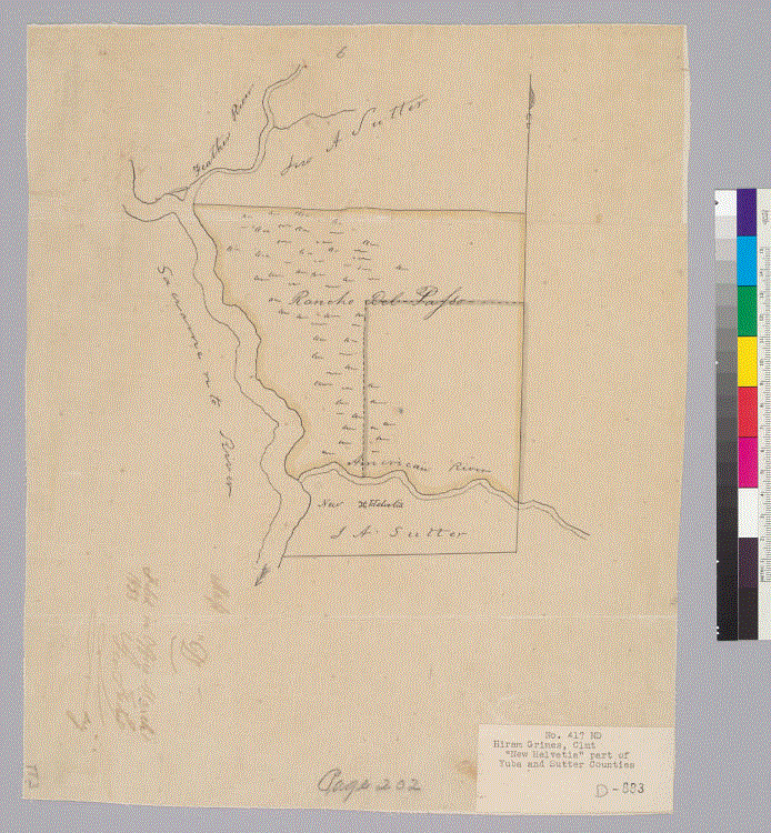
7. U.S. District Court. California, Northern District. Land case 341 ND, page 143; land case map D-695 (Bancroft Library, UC Berkeley).
8. U.S. District Court. California, Northern District. Land case 359 ND, page 649; land case map F-743 (Bancroft Library, UC Berkeley).
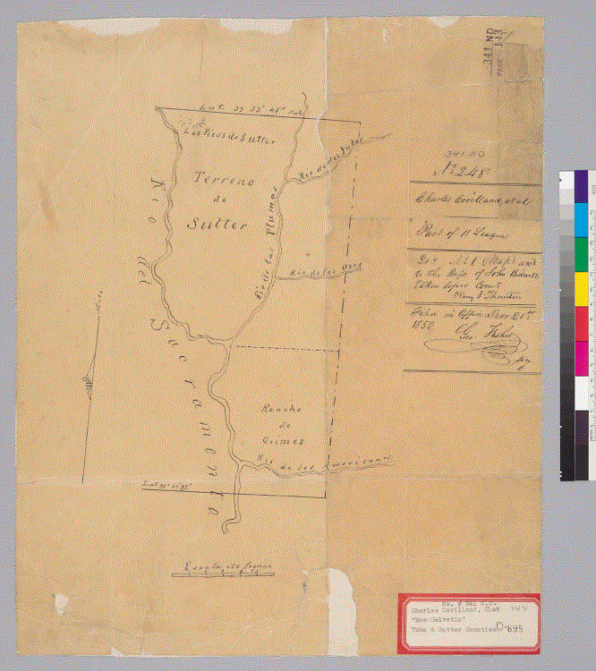
9. U.S. District Court. California, Northern District. Land case 417, page 202; Land case map D-883 (Bancroft Library, UC Berkeley).
10. Wikipedia, “Ranchos of California”.
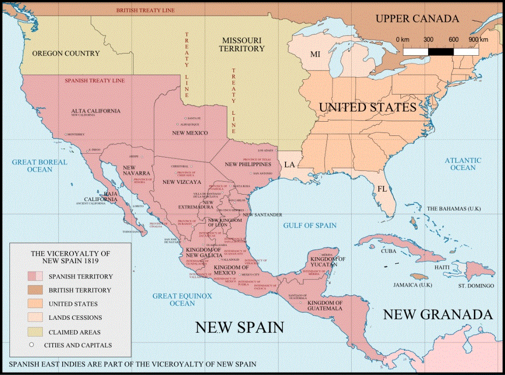
11. Wikimedia Commons, the free media repository, “Viceroyalty of New Spain after the Adams-Onis Treaty of 1819 (Not including the Spanish overseas territories of the Pacific Ocean)”, A map created using information from the United States Geological Survey, an agency of the United States Department of Interior 1810, 1820 and from the Secretary of the Public Education of Mexico (La Secretaría de Educación Pública de México).