|
Report on the Geology and Geologic History of
the Little Poleta Field Area |
|
|
Author: |
|
|
Abstract
|
|
|
Introduction
|
|
|
Background
|
|
|
Methods
|
|
|
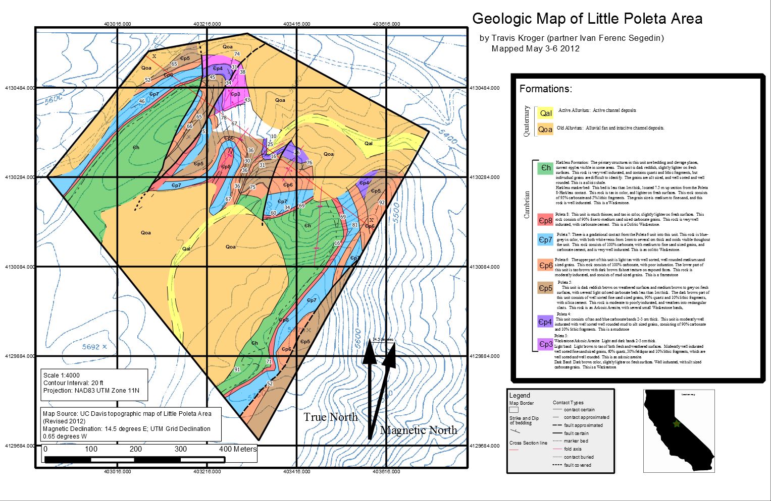
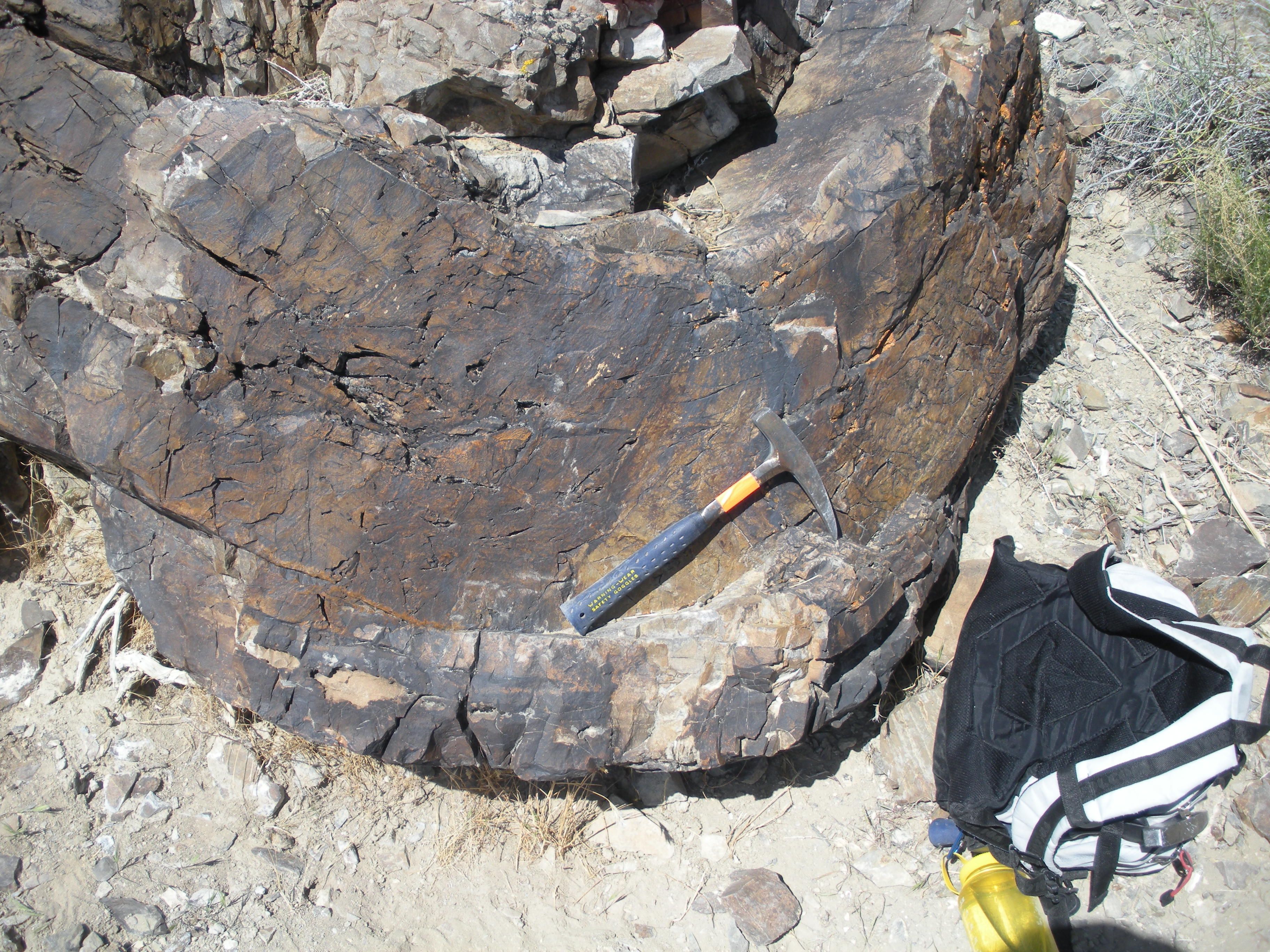
Stratigraphy: Poleta Formation: Poleta 3(cp3): This unit consists of interbeded layers of light colored Arkosic Arenite, and dark brown Wackestone. The Arkosic Arenite beds are light brown to tan on both fresh and weathered surfaces, and consist of fine sand-sized grains of quartz, feldspar, and lithic fragments, and are moderately well indurated with well-sorted well-rounded grains. The Wackestone beds are dark brown on weathered surfaces, with slightly lighter color on fresh surfaces. This rock is well indurated and consists of well-sorted silt-sized carbonate grains. (Figure 4) 
Poleta 4:(cp4): This unit consists of tan and blue interbeded carbonate mudstone. This unit is moderately well indurated, and consists of mud to silt-sized carbonate grains and silt-sized lithic fragments. At the top of this unit, there is a 20 cm thick marker bed directly below the ?p5 contact which consists of carbonate mudstone, brown-colored on weathered surfaces, and blue-grey on fresh surfaces. (Figure 5) 
Poleta 5(cp5): This unit consists of thick reddish-brown Arkosic Arenite with several light colored Wackestone bands less than 1m thick. The Arkosic Arenite is dark reddish-brown on weathered surfaces and medium brown to grey on fresh surfaces. This rock consists of well sorted fine-sand sized quartz grains and lithic fragments with silica cement, is moderate to poorly indurated, and weathers into rectangular chunks. (Figure 6)  Poleta 6(cp6): The lower section of this unit is a Framestone which is brown to tan in color, with a darker brown fishnet texture visible on exposed faces. This texture persists through most of the unit, and is filled in with lighter brown carbonate mudstone (Figure 7). This rock is moderately well indurated and consists of well-sorted mud-sized grains. The upper section of this unit is a light tan carbonate Grainstone. This rock is poorly indurated and consists of medium to fine sand-sized carbonate grains.  Poleta 7(cp7): There is a gradational contact from Poleta 6 into this unit. This unit is a blue- grey carbonate, with white carbonate veins from 1mm to several cm thick throughout the unit, with ooids present in some exposures. Weathered surfaces are grey to tan in color, and fresh surfaces are blue-grey. This rock consists of medium sand-sized carbonate grains with carbonate cement and is very well indurated. This rock is an oolitic Wackestone. (Figure 8)  Poleta 8(cp8): This unit is much thinner (~7.5m) and is tan in color and slightly lighter on fresh surfaces. This rock consists of fine to medium sand-sized carbonate grains and lithic fragments with a carbonate cement and is well indurated. This unit is a Wackestone. Harkless Formation (ch): The primary structures in this unit are bedding and cleavage planes, with current ripples visible in some exposures. This unit is dark reddish-brown, with slightly lighter color on fresh surfaces. This rock contains silt-sized quartz grains and lithic fragments and is very well indurated. This rock is a silicic shale. Harkless marker bed: This unit is a thin (less than 1 meter) marker bed 7.5 m up section from the Poleta 8-Harkless contact. This rock is a Wackestone which is tan in color and lighter on fresh surfaces. This unit consists of medium to fine sand-sized carbonate grains and lithic fragments, and this rock is well indurated. Poleta 3(cp3): This unit consists of inter-bedded carbonate and sandstone, so the depositional environment was likely in a near shore area where relatively small changes in water level would cause a shift between carbonate and sandstone deposition. Poleta 4:(?P4): This unit consists of inter-bedded layers of carbonates of alternating color. This unit was probably deposited in an environment with deeper water that also underwent regular changes similar to Poleta 3. Poleta 5(cp5): This is a thick sandstone unit with occasional carbonate beds, so the unit was likely deposited in a near shore environment, with infrequent changes in deposition. Poleta 6(cp6): The lower part of this unit has a brown fishnet texture that supports the rock and is filled in with lighter colored carbonate. This texture is likely caused by coral growth which was later buried by carbonate sediments, forming a Framestone. The upper part of this unit is a larger grained carbonate, which shows a change in depositional environment away from a setting where coral would be prevalent. Poleta 7(cp7): This unit is also a carbonate, and the presence of ooids suggests that this rock was deposited in an ocean environment,while the white carbonate veins were deposited later. Poleta 8(cp8): This unit is also carbonate, but is thin relative to the other units, so it was likely deposited during a change in environment which persisted for a much shorter time, or during a much slower period of deposition than the other units that were mapped. Harkless Formation (ch): This unit is a sandstone and shows depositional layering and current ripples, which suggests that the rock was deposited in a near shore environment. Structure: Folds: This area has undergone pervasive folding, and there are a number of synformal and antiformal structures present in the map area. The folding structures all occur along the cross-section line, so they will be described moving left to right along this line. The first folding structures are exposed in the northern-most exposure of Poleta 4 and Poleta 5 in stratigraphic sequence (Figure 9&10).  These are both exposures of a fold which has a trend of 228 degrees and a plunge of 38 degrees. This fold is an overturned antiform and shows a dextral rotation sense. Moving south-east along the cross- section line, the next folding structure is a overturned synformal fold (Figure 11). The bedding of this fold is exposed on the hillside and can be seen when looking south along the fold axis at the bottom of the hill. Units Poleta 5-Poleta 8 are deformed by this fold. The upper limb of the fold has been eroded, s o only Poleta 7 and Poleta 8 remain in much of the upper limb. The next folded structure is an exposure of Poleta 4, and an exposure of Poleta 5 both showing antiformal folding, separated by a fault showing oblique normal separation. The last fold, located on the eastern edge of the map area, is also an overturned synform. Units Poleta 4-8 and the Harkless formation are deformed by this fold, but much of the upper limb is eroded. As a result, the units which are visible appear in reverse stratigraphic order on the hillside due to the overturned nature of this structure. There is also a fault which bisects this fold at an oblique angle, offsetting the units in the upper limb of the fold. Foliations: Both Poleta 5 and the Harkless formation show foliations which persist throughout the units. Poleta 5 shows both foliations and cleavage planes which cause the unit to weather into rectangular chunks. The Harkless formation also shows foliations, which cause the rock to break both along bedding planes, and also cleavage planes which have a different angle than the original bedding. Faults: There are four faults which have been identified in the map area, which will be again described from left to right (west to east) along the cross- section line. The first fault strikes north-northwest, and truncates units Poleta 3-8 and the Harkless Formation, showing right lateral separation. The second fault also truncates the same units, strikes in the same approximate direction, and shows right lateral separation. The third fault was only mapped for a short distance due to the rest of the fault being buried by alluvium. As described in the folding section, this fault separates the adjacent antiformal exposures of Poleta 4 and Poleta 5, showing right lateral separation. The fourth fault is located on the east side of the field area, and strikes north-east. This fault cuts Poleta 5, 6 and 7 shows right lateral seperation. |
|
|
Figures and Maps Stratigraphic Section | |
|
Analysis Geologic History:
The folds in the map area can be
categorized as first order or second order folds depending on the
scale of reference. The fold shown in Figures 9&10 is a
relatively small fold and can be interpreted as a second order
fold in one limb of the larger fold structure in that area. The
other two larger overturned synformal folds |
|
|
Conclusions The geology of this area is very interesting and complex, and further work in this area could include relating some of the structures found in the Little Poleta area to those found in the surrounding area. |
|
|
References |