| Title PROXIMITY AND CONVENIENCE OF PUBLIC TRANSPORTATION FOR SENIOR CITIZENS IN ROSEVILLE, CALIFORNIA | |||||||||||||||||||||
|
Author Justin Cahoon American River College, Geography 350: Data Acquisition in GIS; Fall 2014 Contact Information (916)-742-5313, jrockcahoon@gmail.com | |||||||||||||||||||||
|
Abstract As the age of our community members continue to grow, so will the need to provide them with transportation options for personal, professional, and recreational desires. The goal of this study is to analyze the public transit options within Roseville, California, specifically centered on the senior population as it pertains to age demographics and senior community location statistics. Transit routes from Roseville Transit’s local fixed route services were assessed through the use of GIS, which was used to evaluate their proximity to senior community locations. The results from these findings were then used to develop a comparison and recommendations for those communities with access to public transportation versus those considered to be underserved. Transit route and stop data were both created and gathered to develop and analyze a transit map of the study area. This map was then analyzed to assess proximity and walkability of each senior facility in relation to each transit stop (a maximum of a quarter-mile was considered walkable). The results from the tests performed in this study show that the majority of senior living facilities in the Roseville area are adequately served by Roseville Transit, with a few exceptions when taking into consideration this study’s “quarter-mile walking distance” parameter. When analyzing the most recent and reliable transit stop data (provided by the City of Roseville) and a walkable route to reach a transit stop, “The Club by Del Webb” and “Silver Ridge Senior Apartments” were still considered to be underserved by Roseville Transit’s local fixed route service. Overall, this study shows that the City of Roseville is sufficiently serving the transit needs of their seniors. Though the transit stop data developed specifically for this study showed a few gaps in service, the transit stop data provided later by the City showed that they are working on new and modified routes and stops to help rectify the needs of those communities considered underserved. | |||||||||||||||||||||
|
Introduction As the age of our community members continue to grow, so will the need to provide them with transportation options for personal, professional, and recreational desires. Though mobility might be something that younger citizens may take for granted, the mobility and independence are of high importance to senior citizens, particularly as they get older. When older Americans reach a point in their lives where their driving is limited or no longer an option, public transportation can play a key role in maintaining their quality of life. If established correctly, public transportation can offer non-motorists mobility, access, and most importantly, overall freedom. While many seniors do not currently use public transportation in their community, research has shown a higher likelihood of using it if it were more readily available and was focused on the destinations most important to them. The goal of this study is to analyze the public transit options within Roseville, California, specifically centered on the senior population as it pertains to age demographics and senior community location statistics. Transit routes from Roseville Transit’s local fixed route services were assessed through the use of GIS, which was used to evaluate their proximity to senior community locations. The results from these findings were then used to develop a comparison and recommendations for those communities with access to public transportation versus those considered to be underserved. | |||||||||||||||||||||
|
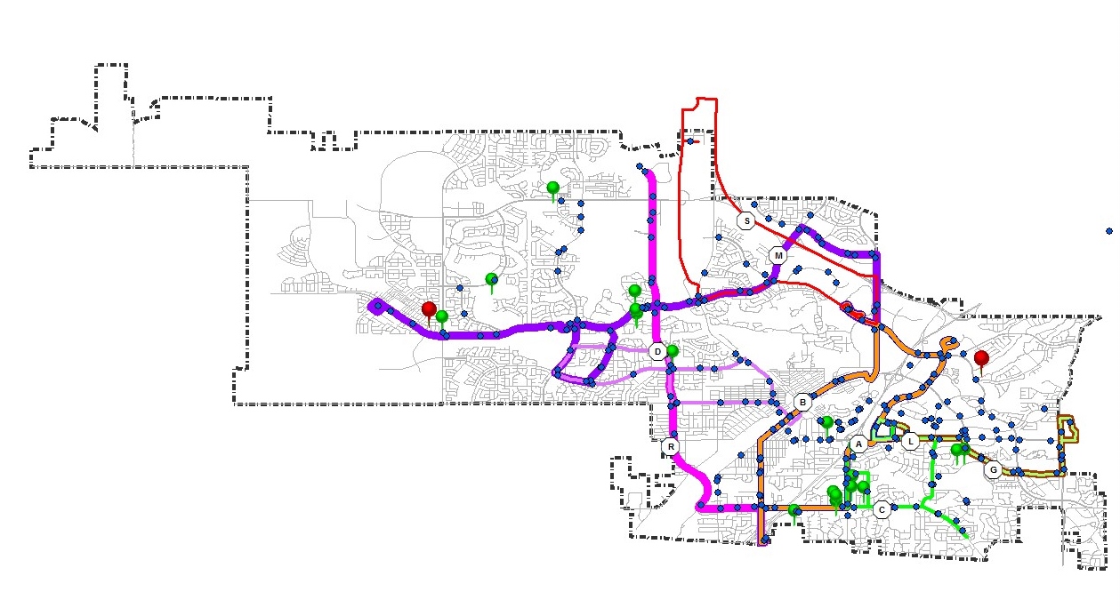
Background For nearly forty-five years, the residents of Roseville, California have enjoyed the convenience of public transportation, allowing them access to their most traveled destinations. Currently, the City of Roseville operates Roseville Transit which includes a fixed-route service, commuter service, and Dial-A-Ride program. Roseville Transit consists of 10 fixed-route alignments serving Roseville weekdays, between 6:00 a.m. and 7:00 p.m. and Saturday, between 8:00 a.m. and 5:00 p.m. The City has four main transfer points (Sierra Garden, Civic Center, Louis Lane/Orlando Avenue, and Roseville Galleria Mall) which provide opportunities for connections between Roseville Transit and various transit operators (Auburn Transit, Placer County Transit, Sacramento Regional Transit, and Lincoln Transit). The Dial-A-Ride program complements the fixed-route service in coverage and service hours. Roseville’s commuter service provides nine morning and evening trips respectively to/from downtown Sacramento during peak-commute hours. The service map of Roseville Transit’s local, fixed route service, was provided by the City of Roseville Transit's website. 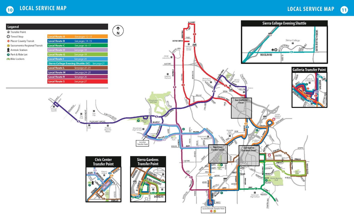 | |||||||||||||||||||||
|
Methods Spawning from multiple literature reviews regarding the importance of public transportation to specific communities (Hanson, 1977 and Rosenbloom, 2004), the inception for this study was to address the unmet needs of senior citizens in a specific area and assess whether or not local transit routes should be modified to include the underserved. To do this, data was not only gathered from City and County sources, but new data was also created to visualize and analyze if the transit service in this area was meeting the needs of their seniors. 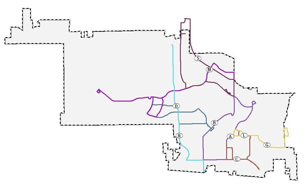 GIS Data from the City of Roseville’s website was compiled and assessed for validity and used as a starting point to create a transit route map in ArcGIS. Route configurations, as well as ancillary data layers were used to produce a draft of the initial service area. Once route data was developed, a database of senior communities was then created (using a combination of Google Maps data and the MS Excel platform) to show to relational locations of these communities. Included in this spreadsheet were latitude and longitude coordinates of each senior facility so that a point based shapefile could be created to visually display these locations in relation to where the transit routes were located. Once the spreadsheet was complete, it was converted to a comma-separated values (CSV) file format so that the table could be imported correctly into ArcGIS. 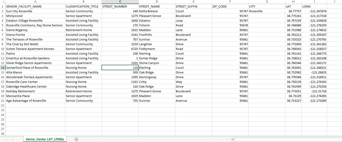
|
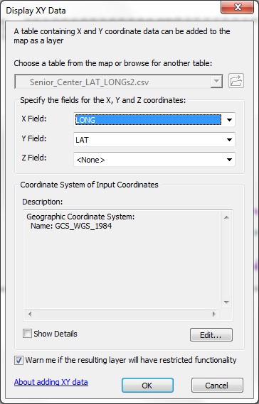 After importing the CSV file into ArcGIS, projection and coordinate information were defined for the file so that it would line up with other shapefiles in the map. Once this was complete, the “Display XY Data” tool was run in ArcGIS which automatically takes the latitude and longitude values in the table and places points on the map according to those coordinates. The points created from this process visually displayed the locations of senior facilities, as they related to the current transit routes. 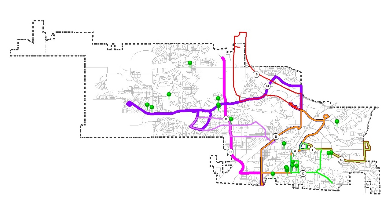
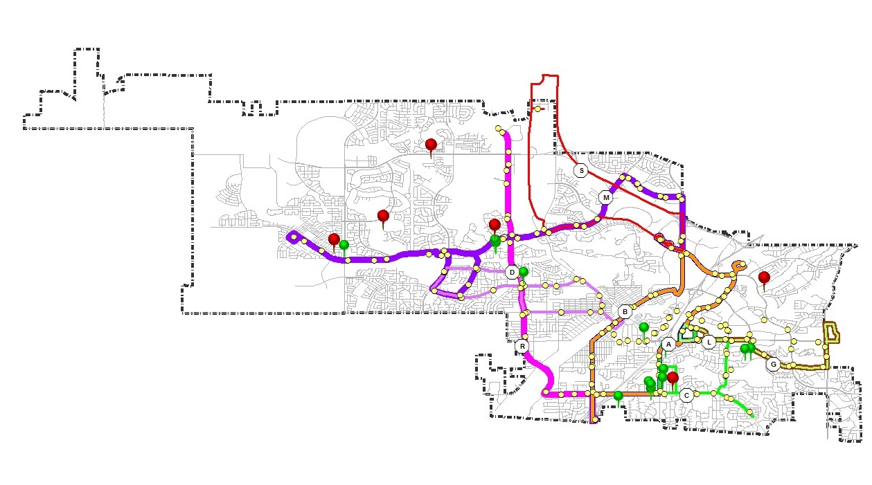
| Though useful, this information alone was not enough to proceed with a proper analysis. To truly assess whether seniors at these locations were within a feasible walking distance to alternative transportation, data on specific transit stops along these routes was needed. It would not be enough to assess whether a senior was within walking distance to a transit route because they would still need to have access to an actual bus stop in order to use the service. Staff at the City was contacted by email in an attempt to obtain coordinate data for each transit stop. Fearing that this information was not available, it was decided that a new spreadsheet should be created with X,Y data for each transit stop. A combination of data included in transit service brochures from the City and data gathered on Google Maps, a spreadsheet was developed which contained the X,Y coordinate data for each of the 215 transit stops within the City of Roseville’s local route service. For the purposes of this study, the City’s “Dial-A-Ride” and Commuter services were not assessed. 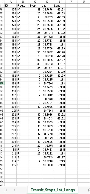 | 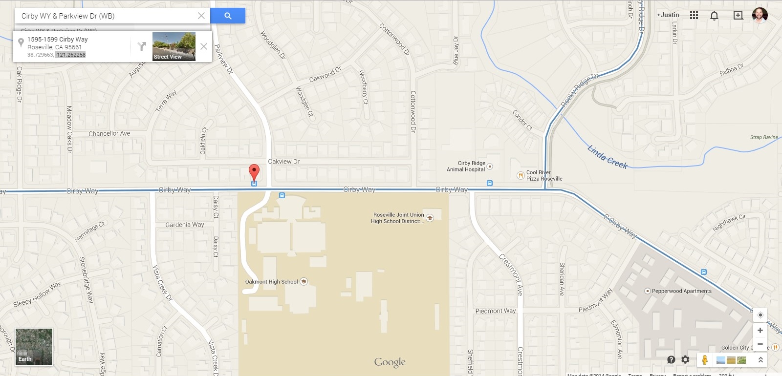 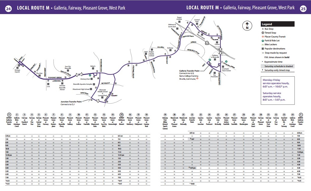 Once this spreadsheet was complete, a shapefile was created using the same “Display XY Data” tool that was detailed above. This resulted in a map that now showed the transit routes, their related stops along each route, and the locations of senior facilities in the area of interest.
| 
| Results After this was complete, the data was ready to be evaluated for spatial processing. For the purposes of this study, it was established that a quarter-mile was considered the maximum amount of walkable distance for which access would be evaluated. Anything outside of a quarter-mile would be considered unreasonable to walk to. To find out which senior locations were outside of the quarter-mile walking distance range (if any), the “Select By Location” tool was used in ArcGIS to highlight the facility locations WITHIN this range. Once a highlighted list of walkable locations were highlighted, the “Reverse Selection” option was selected in the attribute table, now highlighting the locations outside this parameter. It was then established that a simple straight-line distance (or “as the crow flies”) would not be sufficient because more often than not, the route a person must travel to safely reach a location is not a straight line, but rather along a street or sidewalk. For the purposes of this study, it was determined that the “streetline” layer would be used, in conjunction with proximity and routing tools in ArcGIS to establish which locations were not within a straight-line distance to a transit stop, but also, which locations were within the quarter-mile range by street travel. The “Generate Near Table” was used to produce a table that displayed what transit stop was closest to each senior facility and by what distance. The table defaulted to a distance in meters, so a conversion to miles was also produced. It should be noted that only a table for straight-line distance was attempted, and not a table for distance by way of street travel. After the initial straight-line distance test was performed through the “Select By Location” tool, the results showed only three locations were outside of the quarter-mile walkable distance. These facilities are as follows: 1. Sun City Roseville, 2. Eskaton Village Roseville, and 3. Silver Ridge Senior Apartments. 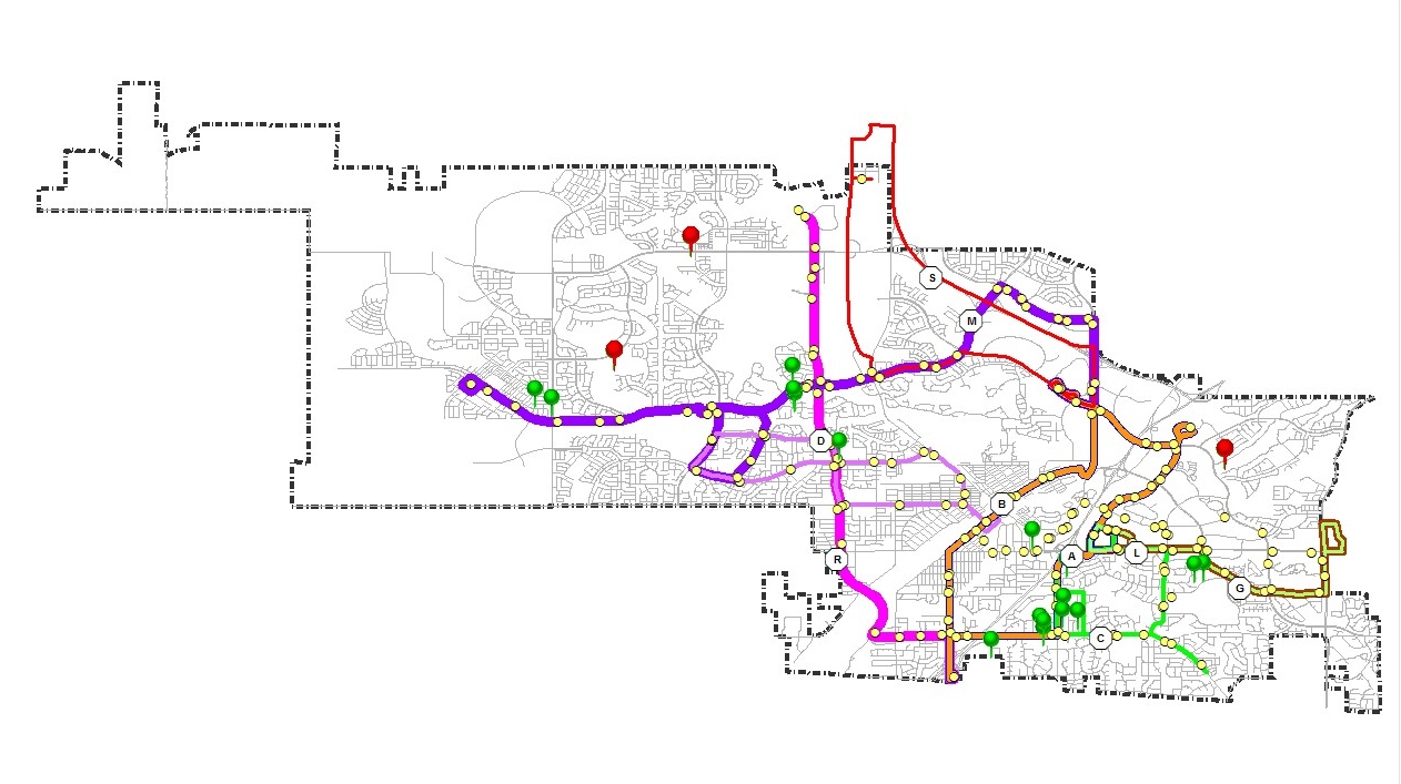 After the secondary distance test, which measured distance along a “streetline” route, was performed, the results produced six locations that were outside of the quarter-mile walkable distance. These facilities are as follows:
1. Sun City Roseville,
2. Mistywood,
3. Eskaton Village Roseville,
4. The Club by Del Webb,
5. Silver Ridge Senior Apartments, and
6. Alta Manor.
 As previously stated, the “Generate Near Table” tool was used to produce a table that displayed what transit stop was closest to each senior facility and by what distance. Again, this analysis was only preformed for the straight-line distance, and NOT the streetline route distance. This test produced the following results: 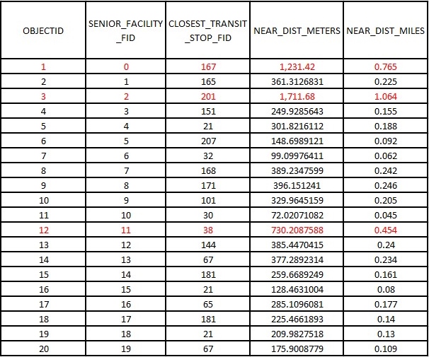 It should be noted that after this analysis was complete and the results were tabulated, an employee at the City of Roseville did provide City transit stop data via email. The data was used to produce a map with transit stops. The transit stop data from the City lined up almost exactly (with minor outliers) with the transit stop data produced for this study, which added a degree of validity. Though the data from the City was not used to provide a complete analysis in this study (because it came in so late), minor tests were run to see if additional measures were currently being applied to rectify Roseville Transit’s “level of service” to provide transportation options to those communities considered underserved. The results showed that additional transit stops WERE added to serve those senior facilities that were outside of the straight-line, walkable distance, however, two facilities were still considered outside the quarter-mile range of streetline route walkability. 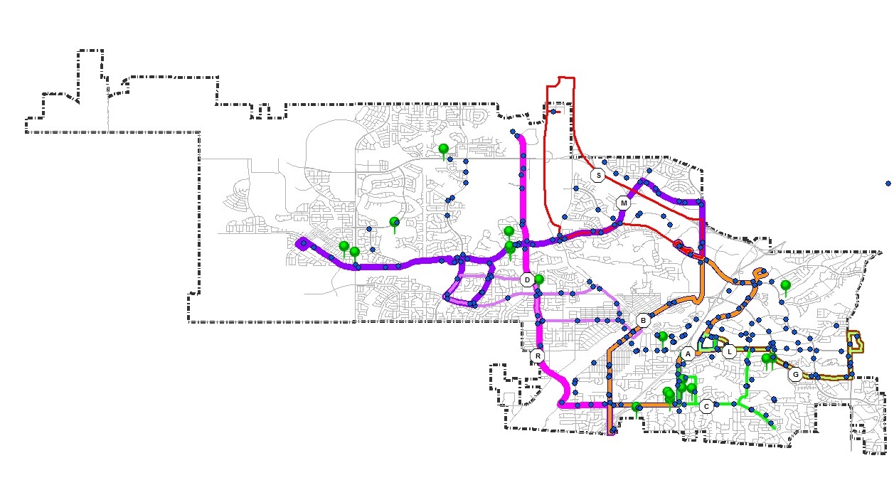 The facilities still underserved (considering streetline walkability) from this data are as follows:
1. The Club by Del Webb and
2. Silver Ridge Senior Apartments.
| Analysis The results from the tests performed in this study show that the majority of senior living facilities in the Roseville area are adequately served by Roseville Transit. From the available data online and from City transit brochures, three communities were deemed “underserved” when considering the straight-line, “as the crow flies” distance. Those underserved with this test are as follows:
1. Sun City Roseville,
2. Eskaton Village Roseville, and
3. Silver Ridge Senior Apartments.
When considering the acceptable walkable routes that a person might take, for instance, traveling along the roads or sidewalks, available public data showed that six communities were deemed “underserved”. Those underserved from this test are as follows:
1. Sun City Roseville,
2. Mistywood,
3. Eskaton Village Roseville,
4. The Club by Del Webb,
5. Silver Ridge Senior Apartments, and
6. Alta Manor.
Though not completely available to the public, nor in any brochure, data directly from the City showed that while all senior facilities were considered adequately served with the additional transit stops when following a straight-line route, there were still two facilities that were outside of the quarter-mile range when following a streetline route. Those still underserved are as follows:
1. The Club by Del Webb and
2. Silver Ridge Senior Apartments
Though data from the City was labeled “…20Nov2014”, which would suggest that it was current at the time of this study, the City was not contacted further to establish whether or not the data was in fact current, correct, or if the additional transit stops were actually in affect. Again, no online research showed the additional stops, they are not provided on any brochure, and many don’t have an associated transit route line connection.
| Conclusions A proper evaluation of the relative level of transportation options (via public transit) for senior citizens in any given area must take into consideration a multitude of variables. For example, desirable and necessary destinations to the specific demographic; available transit stops within walking distance of living facilities; a street and sidewalk network with adequate access, visibility, and safety measures to access said stops; and many others are needed to produce a transit system with optimal ridership. Included in this study are just a few measures that any transit entity can investigate to design a transit system that includes the maximum level of service needed to function for sufficient use by its most “ride dependent” community. Overall, this study shows that the City of Roseville is sufficiently serving the transit needs of their seniors. Though the transit stop data developed specifically for this study showed a few gaps in service, the transit stop data provided later by the City showed that they are working on new and modified routes and stops to help rectify the needs of those communities considered underserved. Additional measures that might be taken into consideration that this study did not attempt might include optimal routes that a senior would take to reach a transit stop; the quality, access, visibility, and safety of the street and sidewalk network used to access each stop; private transit options provided by senior facilities; the “Dial-A-Ride” service provided by the City; and most traveled destinations by the senior community with a focus on medical services.
| References Bento , Antonio M., Maureen L. Cropper, Ahmed Mushfiq Mobarak and Katja Vinha, 2005. The Effects of Urban Spatial Structure on Travel Demand in the United States. The Review of Economics and Statistics, 87(3): 466-478 Hanson, Perry, 1977. The Activity Patterns of Elderly Households Geografiska Annaler. Series B, Human Geography, 59(2): 109-124 Rosenbloom, Sandra, 2004. The mobility needs of older Americans. Taking the High Road: A Transportation Agenda of Strengthening Metropolitan Areas. 227-54. Roseville Transit, City of Roseville. Last accessed December 4th, 2014. http://www.roseville.ca.us/transportation/roseville_transit/default.asp.
| Acknowledgements I would like to thank Cathy Gosalvez, P.E., Assistant Engineer from the Public Works - Alternative Transportation Department at the City of Roseville for providing this project with transit stop data.
| | |||||||||||