| Title Learning GIS in a Virtual World Can a virtual world provide a viable learning environment for GIS? |
|||||||||||||||||||||||||
|
Author Jonathan Crabtree American River College, Geography 350: Data Acquisition in GIS; Fall 2014 Contact Information: jncrabtre@gmail.com | |||||||||||||||||||||||||
|
Abstract While using a virtual game world to explore and learn GIS has some inherent problems, it can be highly beneficial in a school setting to explore data collection and analytical techniques in a unique hands-on way. |
|||||||||||||||||||||||||
|
Introduction An integral part of learning GIS involves the collection and manipulation of data. Data can be difficult to locate and first hand data collection is costly. If there was a way to get data first hand, with ease and at almost no cost it would be very beneficial in a learning environement. What if we were to use virtual worlds to collect this first-hand data and enhance the learning experience? I will attempt to build a GIS environment using virtual world data and determine if it is a viable learning environment. |
|||||||||||||||||||||||||
|
Background The studies I have researched online regarding virtual worlds mainly focus on using virtual reality or virtual worlds to simulate real world conditions. They aim to bring real world data into a virtual world to better interact with it. A paper by Barry Bitters, a senior software engineer for Lockheed Martin Information Systems, describes methods of pulling real world spatial data such as elevation and terrain data to build a virtual world that mimics our own to test military pilots (Bitters). While this is an interesting use of virtual worlds with GIS, my approach is in a way the opposite. I want to extract virtual world data to interact with it within GIS software for the sole purpose of learning GIS software and analytical techniques. |
|||||||||||||||||||||||||
|
Methods The big question I had when starting this project was: “Is this possible?” Can I create functional GIS environments from a virtual game world to perform meaningful tasks? Are there virtual worlds that have the functions necessary to complete this task? Working with many other failed virtual game world options, I established 5 questions that need to be answered for a functional GIS environment to be created. | |||||||||||||||||||||||||
|
1. Are there adequate data mechanics? Virtual worlds often have a built in spatial data. These systems are usually a grid system, much like latitude and longitude. There are often commands which display these values to the player. The purpose of this data is to give the player spatial awareness. It can be used to mark a location or track down a specific destination. A virtual world must have this to be effective in a GIS environment. |
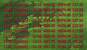 Spatial data displayed from within the virtual world of WildStar by Carbine Studios |
||||||||||||||||||||||||
|
2. Can a scale be established? Scale is very important. If I do not have scale, I cannot relate virtual world information to real world sizes. If the virtual world coordinate system tells me a pathway is 19 units long, what is the true distance? Is that 19 feet? Is it 19 meters? Is each unit 2 feet, or 100 feet? Without an adequate measurement of scale, we cannot give any real world meaning to the virtual data that is collected. |
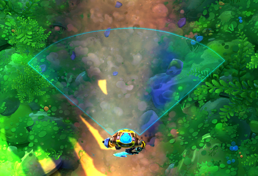 Scale is important to establish accurate measurements |
||||||||||||||||||||||||
|
3. Does the virtual world have a compatible coordinate system? The coordinate data that is collected must be compatible with existing GIS technologies. It must have data that can be equated to longitude and latitude, or east/west and north/south data so our GIS environment can properly interpret it. |
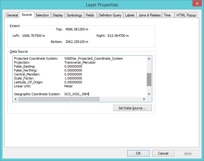 ArcMap allows the creation of custom coordinate systems |
||||||||||||||||||||||||
|
4. Can survey data be effectively extracted from the virtual world? In addition to having compatible coordinate system, the virtual world must have an efficient method of extracting the data. If we are to collect hundreds or even thousands of data points, a quick and easy method of extracting that data must be established. Collecting such data by hand would be impractical. 5. Can useful analysis be performed? Once the GIS environment is setup, we must be able to answer questions that we can use the GIS environment to answer. If meaningful conclusions cannot be made, it has no use as an educational tool. I researched many different virtual worlds. Many did not meet these requirements, but I did finally find one that would fit. The virtual world I will be using is called WildStar by Carbine Studios. My next step would to create this GIS environment from virtual world data and try to solve some simple problems by using ArcMap and my newly created GIS environment. |
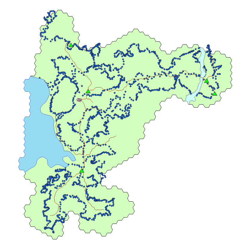 A full geodatabase of data captured from a virtual world, ready for analysis |
||||||||||||||||||||||||
|
Results Now that I have developed my own criteria to evaluate success or failure. I need to evaluate my virtual world to see if it can be used in a GIS environment. |
|||||||||||||||||||||||||
|
1. Discovering the data mechanics WildStar does indeed have spatial data mechanics. There is a command to extract a numeric locational data from the virtual world by a simple command. When you type “/loc” numerical spatial data is returned. I created a small in-game tool called a macro to return this data as well as a time stamp. Now that I had determined useful spatial data existed, my next step was to make sure I could establish scale. |
 Creating a macro to collect spatial data |
||||||||||||||||||||||||
|
2. Establishing scale Scale was established by using the virtual worlds many combat abilities. These abilities list a known range for them. For instance, the “Relentless Strikes” ability has a range of 7.0 meters. By measuring the origin and outer range of these abilities I had two coordinate points. Using the Pythagorean Theorem (A^2 + B^2 = C^3) I could determine the length in coordinate units of the combat ability. By comparing that length in coordinates to the known range of the ability, I established scale. The scale for WildStar happens to be 1 coordinate unit is equal to 1 meter. Now that I had both spatial data, and a scale, I could setup the coordinate system within the GIS environment. |
Calculations for determining an accurate scale 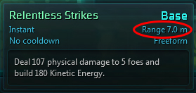 In this case, I used an abilities known range to compare to the coordinate system to determine scale |
||||||||||||||||||||||||
|
3. Creating a custom coordinate system The location data extracted could easily be used in ArcMap. The custom coordinate system would be modeled after GCS_WGS_1984. I selected this specific coordinate system at random as any projected coordinate system would do. ArcMap really only needed some basic information to setup the custom coordinate system. Most notably it needed the scale I had previously established. Not only was it easy to setup this coordinate system, I could save it as a file and mark it as a favorite to conveniently use and store for my GIS environment. Finally I needed to collect some sample data to work with in my GIS environment. |
Sample geo spatial data collected from within the virtual world |
||||||||||||||||||||||||
|
4. Collecting survey data A method of data collection was established by telling the virtual world game client to output the in-game chat log to a file. That way all the collecting spatial data could then be pulled into excel in bulk and converted to tables for use in ArcMap. I spent several hours roaming the world of WildStar tapping my virtual GPS unit to collect spatial data. I traveled up and down hills. I walked to the furthest areas of the map I could. After sufficient amount of data was collected I opened the chat logs in Excel and used “text to columns” function to separate data into a table. I noticed some odd things about the collected data and decided to modify it to make it more clear. The first thing I noticed was that when standing at sea level, the Z coordinate data read -1000. So to make the data easier to interpret I added “1000” to all data points. This preserved the accuracy of the data while making it easier to determine your elevation in relation to sea level. I also inverted the Y (latitude) data. I did this because as you traveled south on the map, the numbers increased instead of decreased. While we could equate this to being a strange alien planet or that simply numbers in this coordinate system go the opposite direction, it was necessary to invert the numbers so that ArcMap would display the data correctly instead of projecting it up-side down. Finally with these modifications, the data could then be easily imported into ArcMap for some meaningful and educational analysis. |
 Hundreds of collected data points, projected in ArcMap using our custom coordinate system  Data was collected from within the virtual world by use of chat logs |
||||||||||||||||||||||||
|
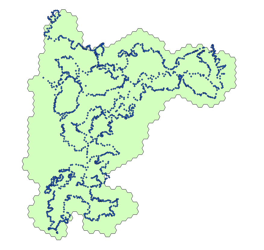
5. Analyzing data to answer questions As a test of meaningful and educational analysis I asked a friend of mine, who is familiar with the virtual world of WildStar, to think of some questions I could answer. Questions that could not otherwise be answered without the use of the GIS environment. His first question was, “How large is the starting zone?” This was very simple to accomplish. I had already mapped the starting zone by geo referencing an in-game map of the zone and tracing it with the polygon tool. With simple use of ArcMap’s Measure tool, I selected the polygon representing the zone and came up with my final result of 1,984,877 square meters or 0.76 square miles. The second question I would solve was: “How many miles per hour does a player run in WildStar?” A seemingly simple question, however likely impossible without the use of spatial analysis and certainly easier with the use of a GIS environment. Speed is a measurement of distance over time. First, I marked off a starting point and ending point within the virtual world as a start and end point for a running route. I measured that route within ArcMap with the measurement functions using the line tool. I came up with a distance of 1327 meters. Next I ran the route three times in the virtual world using a real stop watch. Then I converted meters per second to miles per hour. For a final answer of, on average, a character in WildStar runs about 18.9 miles per hour. |
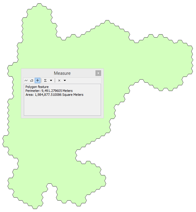 The area of the starting zone was easily obtained by using the measurement tool
Calculations used to determine the running speed of our virtual world character |
||||||||||||||||||||||||
 An elevation map created from collected virtual world elevation data |
Analysis
I have successfully determined that my selected virtual world has appropriate geo spatial data. I have established an accurate scale of measurement. I have interpreted the spatial data into a working custom coordinate system. I have successfully extracted hundreds of data points from a virtual world. And after constructing a geo database of information from the virtual world of Wildstar, I have used it to solve meaningful questions in this virtual world. Something I would not be able to do without the use of the GIS environment. Not only did I answer the given questions, but I also had an opportunity to explore the geo database and come up with many other ideas for geo spatial analysis. I created elevation map, created entirely from in-game elevation data. I surveyed exotic flora and fauna, and I even tracked different types of land cover within this virtual world. I have met all my established criteria for a successful GIS learning environment.
|
||||||||||||||||||||||||
|
Conclusions
This project started as merely curiosity, however every step of the way I was both surprised and excited to learn how well the geo-spatial information could be extracted and used in a GIS environment. Yes, using a virtual world can provide a viable learning environment for GIS. It’s unique ability to offer first-hand data collection as well as its close match to real world environments offers a unique highly beneficial learning environment. However, there are several aspects that keep it from being an ideal process. Swords, spells and lasers can be a huge distraction from the learning process. The virtual worlds available are all video games, and they can only answer virtual world questions and problems until virtual world is created to mimic our real world. The computers required for these virtual worlds are also fairly expensive and a monthly fee is required for these games. These issues aside, it was still a terrific way to explore GIS in a virtual world environment.
|
|||||||||||||||||||||||||
|
References
Carbine Studios. WildStar. December 2014, http://www.carbinestudios.com/ Bitters, Barry. GIS, Virtual Reality and Real-Time Simulation. Accessed Dec 1st 2014. http://proceedings.esri.com/library/userconf/proc01/professional/papers/pap105/p105.htm |
|||||||||||||||||||||||||