|
Title Detection of Unknown Archaeological Sites and Monitoring Archaeological Sites Using Remote Sensing Techniques | |||||||||||||||
|
Author Information American River College, Geography 350: Data Acquisition in GIS w0219859@apps.losrios.edu | |||||||||||||||
|
Abstract My interest for this project was in the use of remote sensing for archaeological purposes. More specifically in finding new archaeological sites and the monitoring of existing sites. I researched articles to find sites that have been discoverd using remote sensing technologies and I wanted to locate one of those sites myself using satellite imagery that I acquired. I document some of the articles that I found and note that many new sites are being discovered using remote sensing. Some additional features at existing sites are also being detected. There is not a lot of documentation of sites being monitored presently. I also document my trials and tribulations of acquiring imagery and also processing one of the images. I did find through my research that archaeologists are utilizing remote sensing technology as a tool for locating new sites and increasing their knowledge base of existing sites. However, sites may not be currently monitored regularly and I speculate as to why it might not be happening. I conclude with the fact that the user of the remote sensing information must be knowledgeable and experienced with the technology to get good and accurate information. | |||||||||||||||
|
Introduction In the recent past most archaeological sites were discovered by people out in the field simply by noticing artifacts or formations that are clearly not natural, in other words, that were made by humans. There are many archaeological sites that have not been discovered due to their locations. Some sites are in locations that are difficult to get to, located under water, buried beneath soil, hidden under a canopy of trees, located in a country in the midst of political upheaval, or they are located in countries that are not friendly to archaeological investigations. Archaeologists have been utilizing new technologies from different disciplines as they are invented for their scientific investigations. Remote sensing is one of these technologies. Forward thinking archaeologists have discovered new sites and additional areas of existing sites using remote sensing. Monitoring existing sites is another use for remote sensing. | |||||||||||||||
|
Background The goal of an archaeologist is to learn as much as possible about a previous culture through artifacts that remain from their time period. Unfortunately a limited number of artifacts remain after hundreds or thousands of years. Rock is the main items that last. For a rock to be considered an artifact it must have been modified by a human. Rock tools are some of the first artifacts studied by archaeologists in addition to remains of rock structures. The more tools that archaeologists can use to study the limited number of artifacts available the more information they are likely to gleen from the artifacts. Archaeologists been quick to take advantage of new technologies to learn more about the past. According to Giardino Archaeologists began using remote sensing technologies in the late 1960´s when Apollo 11 flew. A multiband experiment was included with that mission providing users with infrared photography in addition to black and white photography. The same archaeologist that took advantage of the new technology later used a balloon to fly above a site of interest with the same type of equipment used on the Apollo flight. Archaeologists were on board when some of the first satellite imagery was produced. Archaeologists have continued to use remote sensing as the technology has been improved upon and as new technologies were developed. | |||||||||||||||
|
Method I began by researching scholarly articles to read about new archaeological sites that have been found and sites that are being monitored through the use of remote sensing. I found many interesting articles, mostly of new finds. Below are some samples of imagery I found in some of the articles. The first image was from an article about and existing site that was originally discovered in the early 19th Century. At the site there were two bases of pyramids that were not longer standing or were never built. One of them is titled the "unfinished pyramid". In 2006 two additional pyramid bases were detected through satellite imagery. Apparently the bases of the two additional pyramids were not visible when standing at the site. The image (1) below is of four pyramid bases: 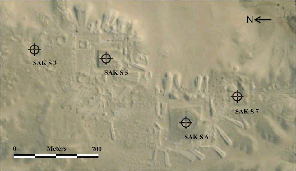 In addition to satellite imagery, geomagnetic surveys, and Ground Probing Radar (GPR) have been utilized by archaeologists. One of the great things about these technologies is that they are non-invasive techniques that allow archaeologists to investigate sites without digging and the possibility of damaging anything or losing information. All three of these techniques were used in Cahuachi (Peru) according to Lasaponara, et al between 2005 and 2008. The image below is a satellite image (2) showing some of their finds: 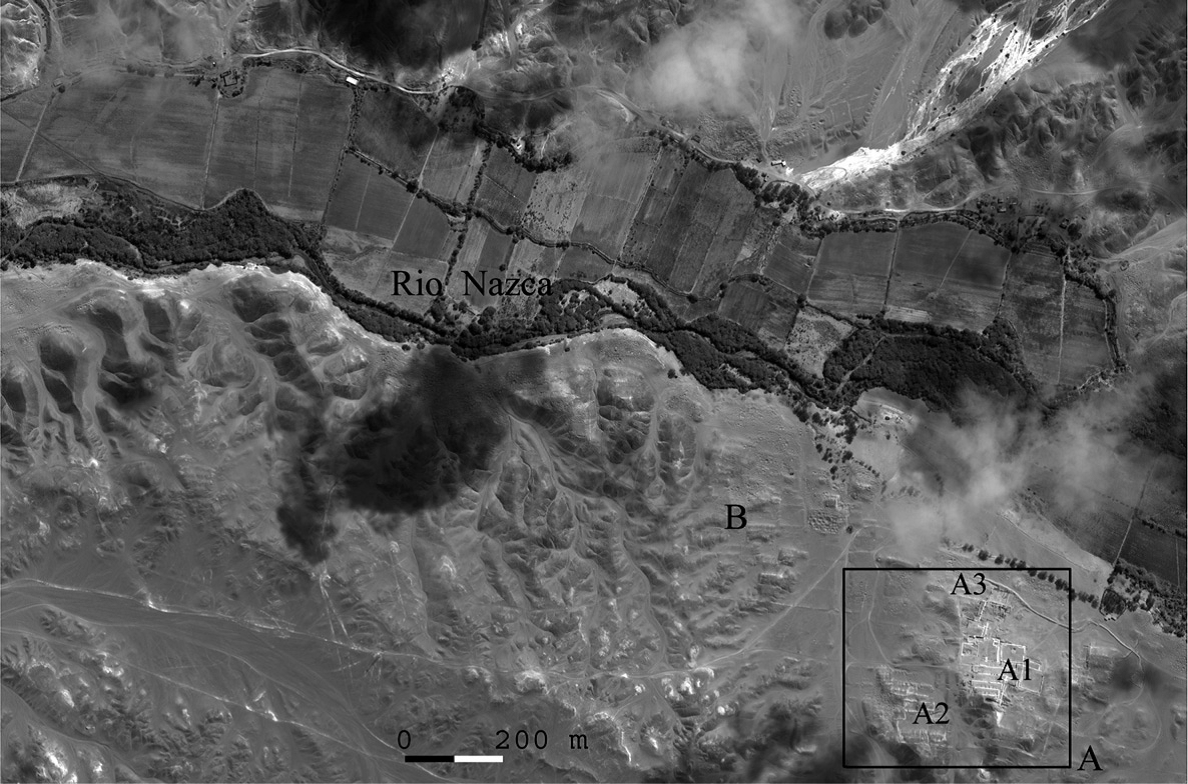 The following image (3) is of a satellite image processing approach used by Lasaponara and Masini. This process allowed Them to discover a huge buried settlement near the Ceremonial Centre of Cahuachi: 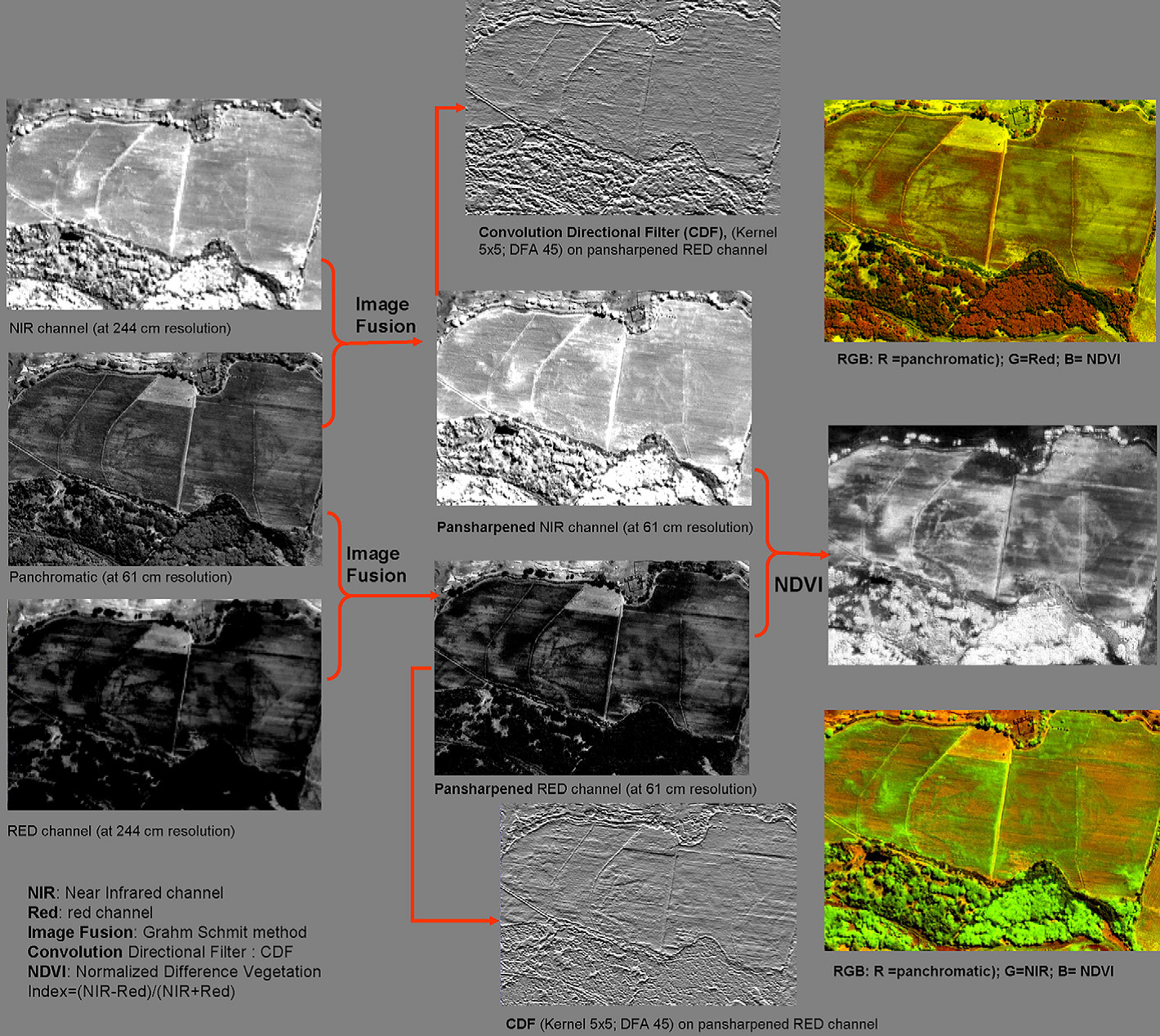 The image (4) below is an image from a LiDAR sensor. Rosa Lasaponara, et al. states that Airborne Light Detection and Ranging (LiDAR) while it may be useful for archaeological purposes it comes with challenges. Each technology has it's challenges and eventually people figure out the best way to use them. The image is a sample of a LiDAR image from a medieval village showing a digital elevation model with a castle (A) and a church (B): 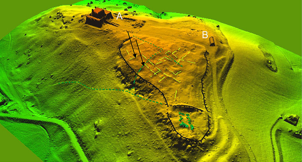 Carlos Eduardo Thompson Alves de Souza, an archaeologist with the International Scientific Committee on Archaeological Heritage Management, discusses the use if LiDAR in his article. He discusses his use of LiDAR in Rio de Janeiro and the understanding that he came to through his experience. Alves de Souza states that "Archaeologists who have not studied the physical principles of remote sensing do not use the full capacity of this technology and thus generate wrong data". Learning to use the technology correctly is one of the biggest challenges.
After researching articles I attempted to find a couple archaeological sites that have been discovered using satellite imagery in Egypt. I spent many hours downloading images from Earth Explorer. I was only able to find Landsat 8 satellite images for the areas that the site were located. I spent a lot of time attempting to find the sites. Once I located one of them I used digital processing techniques to enhance the images. The two techniques that I used were Unsupervised Classification and Supervised Classification to enhance the images. The image below is one of the enhanced images of three pyramids at Giza:  | |||||||||||||||
|
Results Through my research I found that archaeologists are using remote sensing to locate sites and gain more information about existing sites. Archaeologists have been using remote sensing for a lot longer than I was aware of and it is being used all over the world. I did not find much evidence that archaeologists are using remote sensing to monitor sites. I imagine that funding has been an issue in that area. I believe that eventually monitoring sites with remote sensing will become more common as the technology will most likely become more cost effective and when the economy improves. I did not have a lot of success in locating new archaeological sites that were recently found using remote sensing. The digital image processing that I preformed was on an existing, well known site in Egypt, the Pyramids at Giza. I did not have a lot of success processing the image either. | |||||||||||||||
|
Analysis Remote sensing is a good tool for an archaeologist to have in his/her tool kit. Using the technology correctly along with good digital image processing an archaeologist is able to detect artifacts that are not visible to the naked eye. It is an excellent tool because it does damage the artifacts during the process. This enable archaeologists to find and analyze artifacts without losing any potential information. Remote sensing and digital image processing are technologies that need to be mastered. These technologies can easily be misinterpreted by the novice user. The user must know the limitations they are working with. I came across many challenges while trying to find sites and processing the digital images. The first challenge that I encountered was the sites that I was looking for were ancient sites and their locations were not readily available. Exact locations are not published because archaeologists do not want looters or novice archaeologists going to the sites. The second challenge was the resolution of the Landsat images. I could not see the one of the sites once I was positive I knew the location. When I zoomed into the area it was too pixilated to see the site. I was able to find the site on Google Earth. I had tried judging the location by getting the coordinates on Google Earth then entering it into ArcMap. The coordinates were off the image. I was very frustrated because I thought I was doing it all wrong. Then I realized that Google Earth was not very accurate. The image (5) below is a Google Earth image of the Nile. The Nile is located between the yellow and blue lines. It should be between the two blue lines. The yellow line should be one the road that runs along the river. 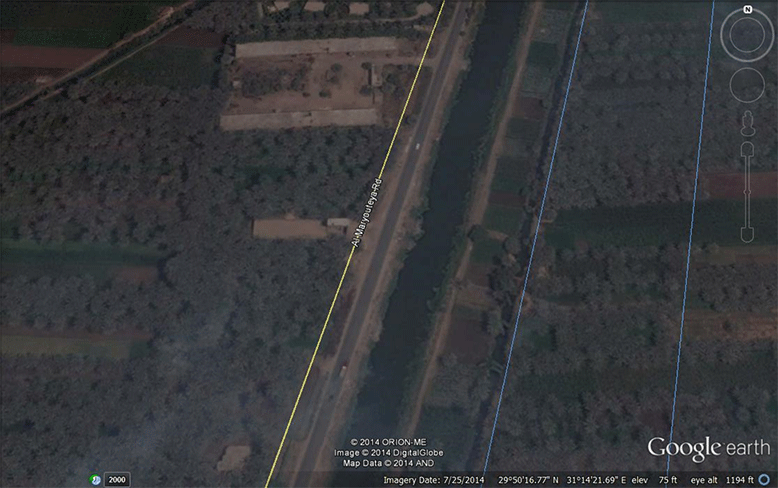 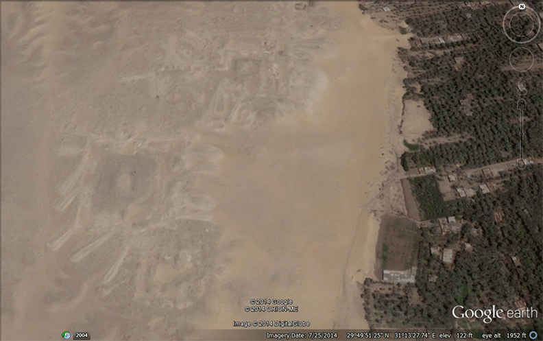 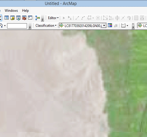 Although I had been able to locate the SAKs site on Google Earth I realized it probably was not the best site because the pyramids were not standing, they were just the bases. If I had images with higher resolution I might have been able to show the site through digital image processing. That is why I chose a known site with the large pyramid to perform the image processing. My lack of experience was another challenge when it came to the image processing. I am not sure that I downloaded the best image to process or I may not have been knowledgeable enough on how to manipulate the bands. I may have missed the infrared band. This is an example of why it is important to be experienced with the technologies to produce quality and accurate results. |
Conclusion Although I had been able to locate the SAKs site on Google Earth I realized it probably was not the best site to try to process the image because the pyramids were not standing, they were just the bases. There wasn´t a lot of definition for the low resolution Landstat image. If I had images with higher resolution I might have been able to show the site through digital image processing. That is why I chose a known site with the large pyramid to perform the image processing. My lack of experience was another challenge when it came to the image processing. I am not sure that I downloaded the best image to process or I may not have been knowledgeable enough on how to manipulate the bands. I may have missed the infrared band. This is an example of why it is important to be experienced with the technologies to produce quality and accurate results. |
Works Cited Alves de Souza, Carlos Eduardo Thompson. 2013. Monitoring archaeological sites with remote sensing & LiDAR - See more at: http://www.geospatialworld.net/paper/application/ArticleView.aspx?aid=30563#sthash.AIPrsMGu.dpuf. June. Accessed November 14, 2014. http://www.geospatialworld.net/paper/application/ArticleView.aspx?aid=30563. Corrie, Robert K. 2011. Detection of ancient Egyptian archaeological sites usingsatellite remote sensing and digital image processing. November 11. Accessed November 25, 2014. http://www.academia.edu/559396/Detection_of_ancient_Egyptian_archaeological_sites_using_satellite_remote_sensing_and_digital_image_processing. Giardino, Marco J. 2011. "A history of NASA remote sensing contributions to archaeology." Journal of Archaeological Science 2003-2009. (a) R. Lasaponara, R. Coluzzi, and N. Masini. 2011. "Flights into the past: full-waveform airborne laser scanning data for." Journal of Archaeological Science 2061-2070. (b) Rosa Lasaponara, Nicola Masini, Enzo Rizzo, and Giuseppe Orefici. 2011. "New discoveries in the Piramide Naranjada in Cahuachi (Peru) using satellite, Ground Probing Radar and magnetic investigations." Journal of Archaeological Science 2031-2039. (c) Rosa Lasaponara and Nicola Masini. 2011. "Satellite remote sensing in archaeology: past, present and future perspectives." Journal of Archaeological Science 1995-2002. Images: (1) Corrie (2) Lasaponara (b) (3) Lasaponara (c) (4) Lasaponara (a) (5) Google Earth (6) Google Earth |
|||||||||||||