| Title Examining Changes in the Spatial Distribution of the San Benito Evening Primrose (Camissonia benitensis) | |
|
Author Katie Gross American River College, Geography 350: Data Acquisition in GIS; Fall 2014 kegross144@gmail.com | |
|
Abstract The federally threatened San Benito evening primrose (Camissonia benitensis) was once thought to be restricted to flat alluvial terraces within its known range. Thorough BLM surveys in 2010 found numerous new occurrences on nearby steeper slopes, a new habitat type for the species. This study looked at the average slopes of C. benitensis occurrences from pre-2010 and post-2010 distributions, using California Natural Diversity Database (CNDDB) and National Elevation Dataset (NED) data. The resulting analysis found that populations can be found on much steeper slopes than originally thought, but that the species may still prefer to grow on more moderate slopes. | |
|
Introduction
| |
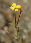 © 2006 Aaron Schusteff |
The San Benito evening primrose (Camissonia benitensis) is a federally threatened species endemic to the inner south coast region of California. This species was originally thought to only occur on flat alluvial terraces, but intensive surveys in 2010 by BLM personnel greatly increased the known distribution. Many of these newly discovered populations were found on more sloped upland areas, which goes against the original notion that this species only occurred on flatter terraces. The goal of this project is to use GIS spatial analysis methods to quantify how much of the currently known distribution occurs on this new habitat type. |
|
Background Prior to 2010, the distribution of C. benitensis populations was thought to be severely limited within the known range for the species. The majority of known populations were located on flat to slightly inclined serpentine alluvial terraces bordering creeks, though it was noted that several of these populations did extend upslope from the terrace or toe slope (Taylor 1990). Even so, surveys for this species primarily focused on searching alluvial terrace habitat within the region, whereas nearby slopes were generally left unchecked if there were no C. benitensis in nearby terraces. Based on these primary assumptions about habitat, there were thought to be only about 16 occurrences of C. benitensis (CNDDB 2014). During the early stages of 2010 monitoring, BLM botanist Ryan O’Dell started to discover isolated populations outside of the alluvial terrace zones. He identified these new upland areas as “serpentine geologic transition zones,” a new habitat type for this species. Once this new habitat type was defined, he intensively surveyed areas fitting this habitat description, finding many new populations and nearly doubling the known population size (O’Dell 2010). Based on a summary of reports through 2014, there are now 60 known occurrences of C. benitensis (CNDDB 2014). 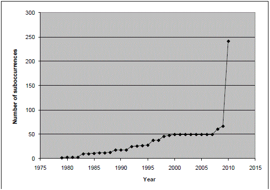 Figure 1: Number of C. benitensis suboccurrences over time (O'Dell 2010) The serpentine alluvial terrace and serpentine geologic transition zone habitat types have many shared characteristics, including soil type, soil stability, and low density woody overstory; they differ in that alluvial terraces are topographically constrained to drainage bottoms whereas geologic transition zones have no such topographic constraint (O’Dell 2010). The purpose of this study is to examine the changes in topographic distribution, by means of comparative slope analysis, between pre-2010 and post-2010 distributions. | |
|
Methods Polygon shapefiles of pre-2010 and post-2010 distributions of C. benitensis were obtained from the California Natural Diversity Database (CNDDB). It should be noted that at the time of this writing, the currently available CNDDB distribution only shows the pre-2010 distribution. Due to my unique position of being an employee at the database, I also have access to the post-2010 distribution polygons that are not yet widely available, but should be distributed in the near future. To obtain slope information, I first downloaded a National Elevation Dataset (NED) raster via The National Map Viewer and Download platform. The particular NED I downloaded was a 2013 1 arc-second raster. Then, I inputted the elevation layer into the ArcGIS slope tool to create a slope raster for the area, with the output slope measurement in degrees. The next step was to find a way to compare C. benitensis polygon layer with the slope raster layer. To determine the average (mean) slope within each occurrence, I decided to use the Zonal Statistics as Table tool. This tool takes an input raster (slope) to be compared with a zone field (occurrence polygons), and the output is a table that summarizes the values of the raster within each of the provided zones. By using the Zonal Statistics as Table tool, I was able to get average slope per occurrence information for both pre-2010 and post-2010 polygon datasets. | |
|
Results
| |
| The results of the analysis are shown here in the form of histograms. These graphs show the number of occurrences that fall within each slope range, based on the value of the average slope within each occurrence. The x axis represents categories of percent slope, while the y axis represents the number of occurrences in each category. |
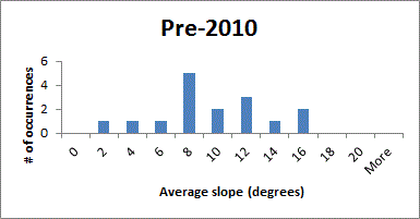 Figure 2: Average pre-2010 slopes per occurrence 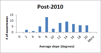 Figure 3: Average post-2010 slopes per occurrence |
|
Analysis By comparing the pre-2010 and post-2010 histograms, it is clear that there is a definite increase in the number of occurrences with a steeper slope, which most likely represent the new geologic transition zone occurrences discovered by O'Dell in 2010. However, the graphs also indicate that the majority of occurrences, based on category, still prefer flatter areas of around 8 degrees in slope. This could mean that while C. benitensis is not exclusive to alluvial terraces, these areas may still represent it’s preferred habitat type. One of the challenges in this project was determining the parameters for the average slope calculation. My first thought was to perform the slope analysis using the centroid points for each occurrence, but that would only provide a fraction of the information for each occurrence. A single occurrence in CNDDB may contain a large polygon, or many polygons, so only obtaining the slope data for only one point of the occurrence would exclude a lot of data. Therefore I decided to use polygons for my analysis, but they are not without problems. As stated, a single CNDDB feature can be represented by a multi-part polygon. When using the zonal statistics tool, the slope values within all of these polygons are condensed into a single value for the entire occurrence. While this does give an accurate depiction of the average slope throughout the occurrence, some of the extremes that may be represented within a single larger occurrence are potentially “watered down” and not depicted in the final analysis. The CNDDB occurrences for C. benitensis contain 3 to 5 of these larger category multi-polygon occurrences, but many smaller single polygon occurrences as well. While it is possible that some of the extremes are not well represented in the resulting graphs, I think this study did a decent job of capturing the overall data trend. | |
|
Conclusions The results of this report clearly show that future surveys of C. benitensis should not be limited to alluvial terrace habitat zones, as was previously done. Although this species may still prefer this habitat type, there is a definite increase of occurrences found on the more sloped geologic transition habitat areas. There are many aspects of this subject that would benefit from future research. The habitat preferences of a species are composed of a variety of different ecological factors; studying the slope of these habitats is only one small piece of the puzzle. The next major direction for study should be soil type. While the new geologic transition zone habitats are still reported to occur on soils derived from serpentine (as compared to serpentine alluvial terraces), the transition zone represents a boundary between serpentine and nonserpentine rock types (O’Dell 2010). It would be interesting to analyze the soil preferences of these new occurrences, to see if the serpentine affinity of this species is also less restrictive than what is currently believed. | |
|
References CNDDB. California Department of Fish and Wildlife, Biogeographic Data Branch. 2014. California Natural Diversity Database (CNDDB). Sacramento, CA. Data downloaded December 2014. National Elevation Dataset, United States Geological Survey: http://ned.usgs.gov/. Data downloaded December 2014. O'Dell, R. 2010. Annual Summary Report for the 2009-2010 Season Monitoring and Status of Camissonia benitensis and Implementation of the 2006 Record of Decision. Bureau of Land Management, Hollister Field Office. Taylor, D. 1990. Ecology and Life History of the San Benito Evening Primrose. Santa Cruz, CA: BioSystems Analysis Inc. | |