| Title GIS Data on Past Present and Future of Wolves in California | |
|
Author M. Rich Ramirez American River College, Geography 350: Data Acquisition in GIS; Fall 2015 Contact Information: Address: 3600 Data Drive, #450, Rancho Cordova, CA 95670 Ph.: 916.812.5881 email: mrichramirez@outlook.com | |
|
Abstract This report represents an overview of the past and current range of grey wolves (canis lupus, hereafter “wolves”) in California with an estimate of their future range based on associated data. | |
|
Introduction Wolves have recently returned to the state of Califorina. We have utilized several sources of geographical data in order to estimate the future range of that species in California as well as predict possible challenges and conflicts. | |
|
Background A general background on wolves in California: California Wolf Center. (Year of publication uncertain). Wolves in California: Historical Background of Wolves in California. http://www.californiawolfcenter.org/learn/wolves-in-california/ Last accessed 2015.09.20 A cultural and archeological treatment on the subject: Sonoma State University. August 2013. Pre-Contact Distribution of Canis Lupus in California: A Preliminary Assessment. http://www.biologicaldiversity.org/campaigns/wolves_on_the_west_coast/pdfs/ASC_Wolf_report_v3.pdf Last accessed 2015.10.11; credit: Anthropological Studies Center/Rohnert Park, CA | |
|
Methods Esri's ArcMap 10.3 was utilized with current and historic wildlife data, census data and park data. The park data provided locations of protected open spaces, which were broadly defined, as possible wildlife habitat. | |
|
Results and Maps
| |
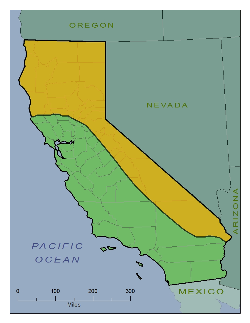
| Historic Range Wolves were historically present in California and were eradicated from this state sometime between the mid-1920s to as late as 1937. The orange areas on the map to the right indicate the historical range of wolves within the state of California. Wolves were present in the entire northern portion of the state, from approximately the current location of the city of Colusa, or a latitude of 39.2 degrees north. The foothill, mountain and desert regions on the eastern border of the state were historically within the range of wolves. This includes, but is not limited to, the entirety of Alpine and Mono counties, nearly all of Inyo county and major portions of Tuolumne, Fresno and San Bernardino counties. No wolves were historically present in the areas south of approximately the city of Redlands, or a latitude of 34.1 degrees north. This leaves nearly the entire Central Valley, most of the coast and extreme southern portion of the state outside of the historical range of wolves. This data was used in our analysis as a maximum likely range for future wolf populations. |
|
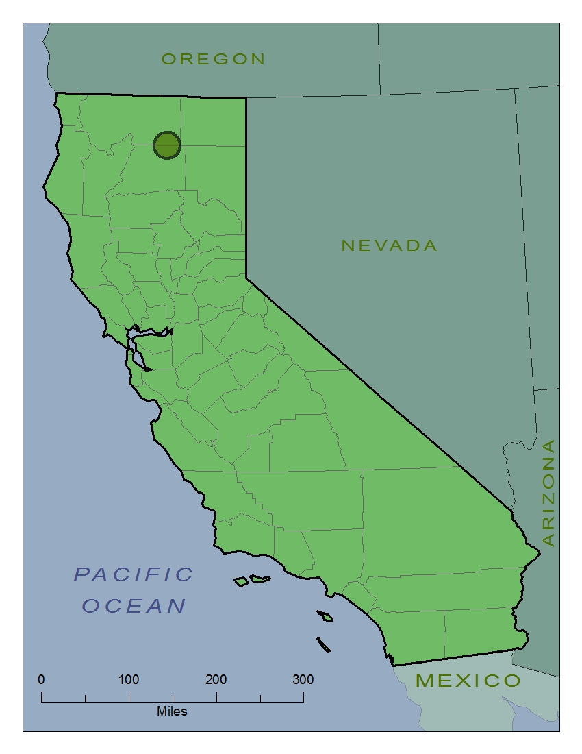
| Range of Wolf OR-7 OR-7 is the designation for a young lone male wolf that wandered throughout the northeastern portion of the state, via Oregon, from December 2011 to at least April 2013. This makes OR-7 the first confirmed wild wolf in California since approximately 1924. The red portion in the figure to the right indicates the range of the wolf called OR-7 within the northern/central portion of California. He visited portions of Siskiyou, Modoc, Shasta, Lassen, Plumas, Tehama and Butte counties. The farthest eastern point was approximately at a longitude of 120.5 degrees west. The farthest western point was approximately at a longitude 122.8 degrees west. The farthest southern point was just a few miles north of the city of Chico at a latitude of about 39.8 degrees north. This data was combined with the historical range as very strong positive evidence of suitable habitat for future wolves. |
|
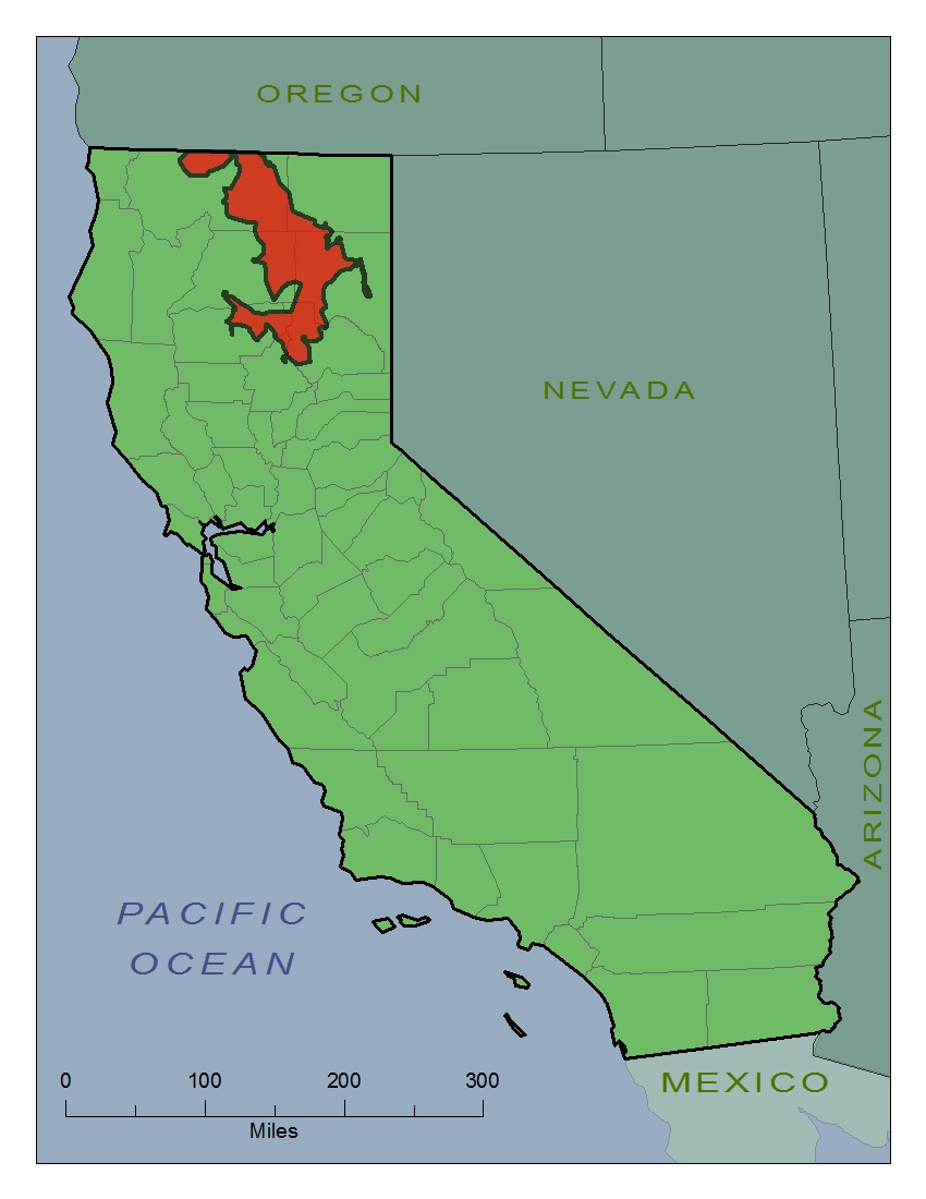
| Current Range Recently, in the spring of 2015, a small family of wolves was discovered to be established within California. This is the first wild wolf pack within the state since eradication in the 1920s or thirties. The green area in the image on the right indicates the current range of the “Shasta Pack,” currently the only wild wolves in California. This area is in the southeastern portion of Siskiyou County and the northeastern portion of Shasta County. This area is centered on approximately 121.7 degrees west longitude and 41.2 degrees north latitude. This area is approximately 1800 square kilometers, since our sources indicate this is the approximate territory ranged by a wolf pack. This data was combined with the historical range and area visited by OR-7 as very strong positive evidence of suitable habitat for future wolves. |
|
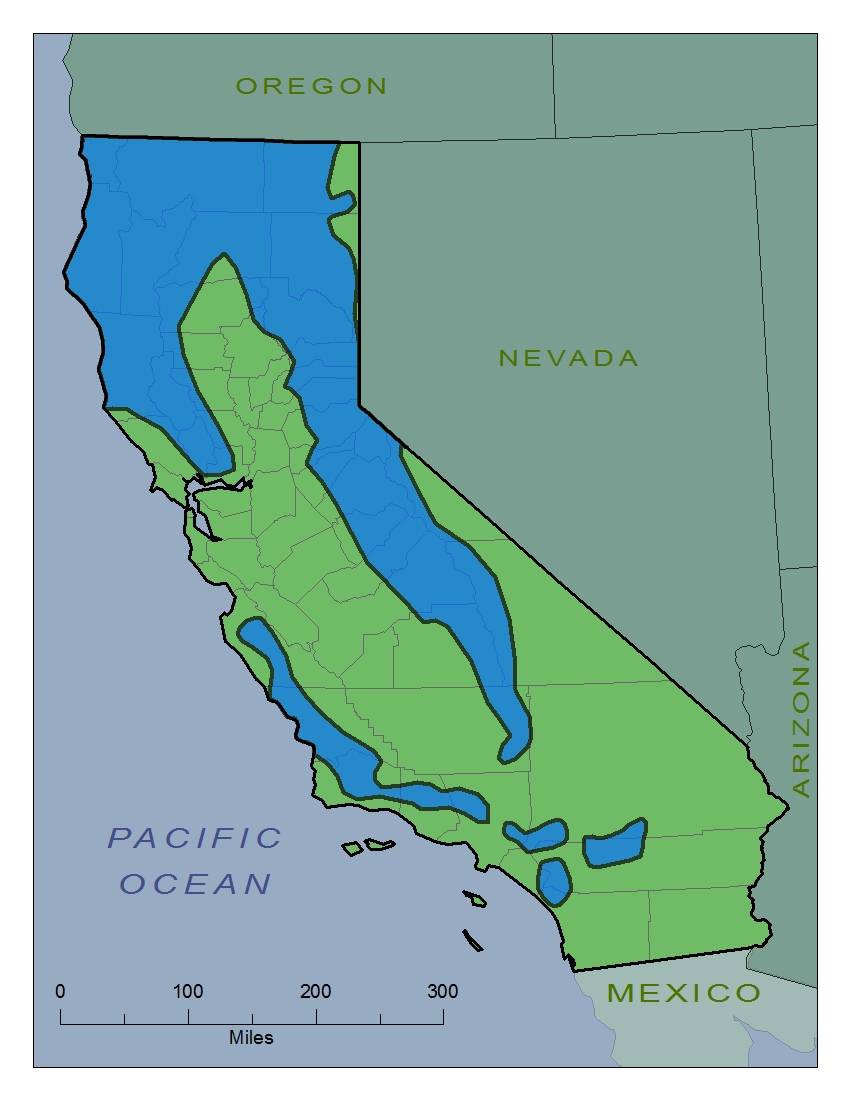
| Black Bear Range American black bears (ursus americanus) were historically present and still exist in California. They are arguably the largest carnivores in California, with the possible exception being the puma (puma concolor). The blue portion to the right indicates the current range of American black bears within the state of California. This area is equal to approximately 161,000 square kilometers. This a major portion of the state including the entirety of Alpine, Siskiyou, Lake, Humboldt and Trinity counties with major portions including, but not limited to, Shasta, Lassen, Plumas and Mendocino counties. This represents over one third of the state with major regions of the extreme north, foothills, Sierra Nevada and Coastal Range represented. Major portions of the Central Valley, San Francisco Bay Area, desert locales and extreme south are devoid of this species. This data will be utilized as strong evidence that a location is currently suitable for wolves. Black bears have a similar range to the historic range of wolves. Other carnivorous species, such as coyotes (canis latrans) or pumas, have very different distributions to the historic range of wolves and would therefore like be poor substitutes. Prey species, such as mule deer (odocoileus hemionus) also seem to be poor predictors in this area. |
|
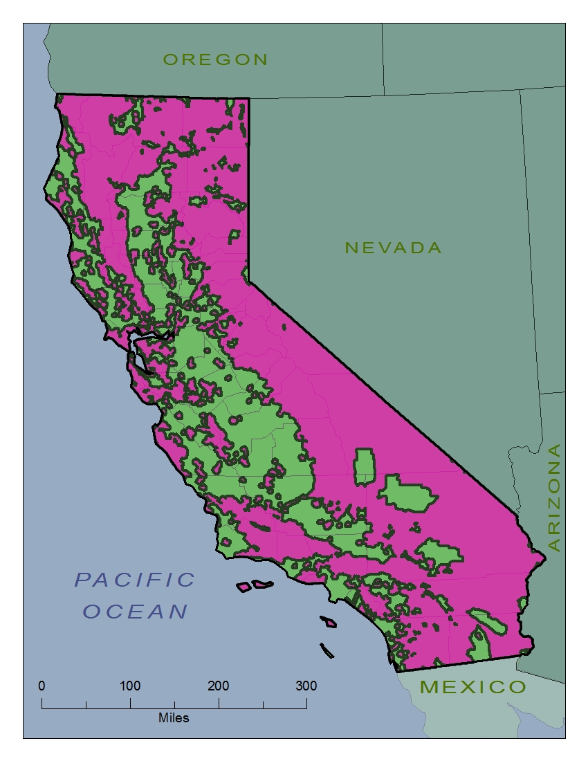
| Protected Open Spaces The magenta areas to the right represents open spaces and otherwise protected public areas. These areas are distributed throughout the state with slightly fewer of the protected spaces in the Central Valley and coastal areas and larger groupings in the extreme north, eastern edge, the Sierra Nevada and desert regions. The entirety of Alpine county and major portions of Mono, Plumas, Trinity and Inyo counties, among others, are represented. These areas total approximately 283,000 square kilometers or about two thirds of the state. This data provides evidence of suitable wolf habitat, especially if it is coincident with black bear habitat and historic wolf habitat |
|
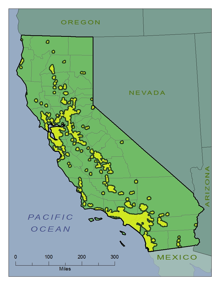
| Urban Areas The yellow portion of the image to the right represents urban areas. For the sake of this report urban areas are defined as having more than 750 people per square mile (or about 300 people per square kilometer). This figure is consistent with definitions utilized by the U.S. Census Bureau. These areas are spread throughout the state with more urbanization in the Central Valley, San Francisco Bay Area and the southwestern coast around the greater Los Angeles metropolitan area. The extreme north, the Sierra Nevada, southeastern desert regions, foothills and Coastal Range are largely devoid of urbanization. San Francisco is completely urbanized, as are most of Alameda, Contra Costa and Orange counties. The only counties lacking urbanization are Trinity, Modoc, Plumas, Sierra, Alpine, Amador and Mono. This data provides strong evidence of lack of suitable wolf habitat. |
|
|
Final Map
| |
| |

| |
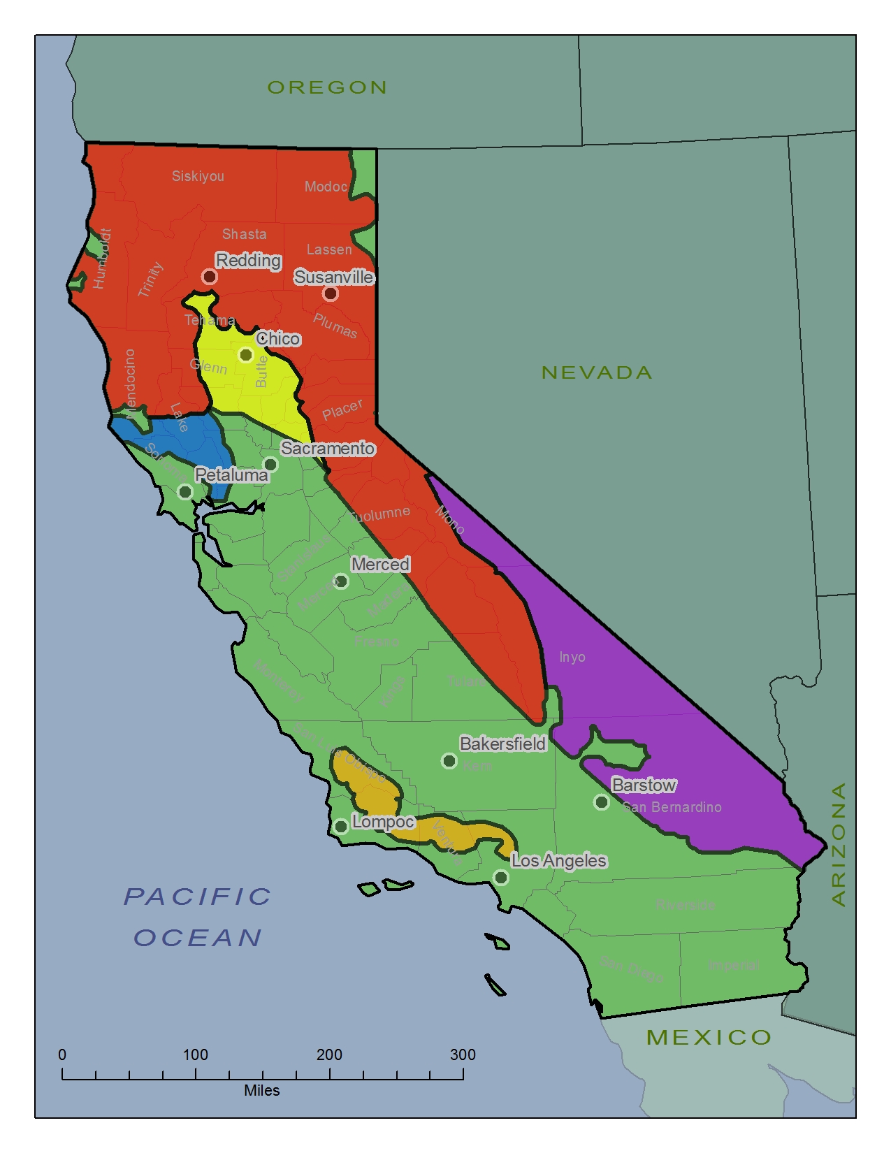
| Likely Habitat This area represents the most likely future range of wolves based on historical and recent presence of wolves, plenty of protected open space, limited urbanization and presence of black bears. These areas represent the extreme north, north coast, Cascade Range and Sierra Nevada regions of the state. This area includes the entirety of Siskiyou, Trinity, Plumas and Del Norte counties with major portions of Modoc, Lassen, Humboldt, Shasta and Mendocino counties represented. Some coastal portions in Humboldt County, primarily near Eureka and Arcata, have been removed due to lack of protected open space and urbanization. Some small areas in eastern Lassen and Modoc counties have also been removed due to lack of black bears. |
|

| |
| Unlikely Habitat This area represents land that was previously occupied by wolves but may no longer be suitable due to urbanization and lack of protected open space. The lack of black bears in this location also bodes poorly for the prospects of wolves here. This area is mainly made up of major portions of Glenn, Butte and Tehama counties and represents the extreme northern portion of the Sacramento Valley. |
|

| |
| Possible Habitat This area represents land that was previously occupied by wolves but may no longer be suitable due to lack of black bears. However, this area does have plenty of protected open space and very little urbanization. It is possible that black bears represent a poor indicator of suitable wolf habitat. This area includes major portions of Mono, Inyo and San Bernardino counties and represents the Eastern Sierra, Mojave and Great Basin portions of the state. Large areas around the military installations of China Lake and Fort Irwin have been excluded, since such areas are not likely suitable for wolves. |
|

| |
| Potential Habitat (Contiguous) This area is outside, but adjacent to, the historical range of wolves but may be suitable for future wolves based on limited urbanization, plenty of protected open space and presence of black bears. This area includes a large percentage of Lake County, nearly all of Napa County and primarily represents the hills to the west and north of Lake Berryessa. Please note the major portion around Ukiah has been excluded due to lack of protected open space and urbanization. |
|

| |
| Potential Habitat (Non Contiguous) This area is outside the historical range of wolves but may be suitable for future wolves based on limited urbanization, plenty of protected open space and presence of black bears. This area composed of portions of San Luis Obispo, Santa Barbara, Ventura and Los Angeles counties that straddle the Los Padres National Forest. |
|
|
Analysis The results above are promising though some questions remain. Chief among them is whether the range of black bears is is a good representation of future wolf range. | |
|
Conclusions Some previous wolf habitat, though not all, are still well suited and will likely have thriving packs in the future. Some challenges and opportunities will exist for these or other areas in the future. | |
|
References California Department of Fish and Wildlife. (Year of publication uncertain). Gray Wolf OR7 Travels https://nrm.dfg.ca.gov/FileHandler.ashx?DocumentID=42104&inline=true Last accessed 2015.12.15 California Protected Lands Data Portal. 2015. California Protected Areas Database http://www.calands.org/data Last accessed 2015.12.15 Esri: Data & Maps. 2010. U.S. Census Block Groups http://www.esri.com/ (Data provided with ArcMap 10.3 GIS software) IUCN Red List of Threatened Species. 2010. Canis lupus http://www.iucnredlist.org/details/3746/0 Last accessed 2015.12.15 IUCN Red List of Threatened Species. 2008. Ursus americanus http://www.iucnredlist.org/details/41687/0 Last accessed 2015.12.15 The Siskiyou Daily News. 2015. "California's First Documented Wolf Pack Recorded in Siskiyou County" http://www.siskiyoudaily.com/article/20150820/NEWS/150829974 Last accessed 2015.12.15 United States Fish and Wildlife Service. (Year of publication uncertain). Historic Gray Wolf Range. http://www.fws.gov/midwest/wolf/images/maps/historicalrangeHall1981.jpg Last accessed 2015.12.15 | |