|
Title |
|||||||
|
Author
|
|||||||
|
Abstract
|
|||||||
|
Introduction
(http://www.foresthistory.org/ASPNET/Publications/region/5/six_rivers/sec4.htm).
Today Six Rivers NF has 957,590
acres of National Forest and 133,410 additional acres not under federal
ownership (http://www.fs.usda.gov/main/srnf/about-forest). The Six Rivers NF
is a narrow strip of land that extends 140 miles from the Oregon border to
Mendocino County down south. Approximately 43% of Six Rivers NF is in Del
Norte County. With 35% in Humboldt county, 21% in Trinity County and lastly
1% in Siskiyou County. (http://www.fs.usda.gov/main/srnf/about-forest). For
the purposes of this project, focus will be on forest that is solely within
Humboldt County. Old Growth forests make up
approximately 137,000 acres of the 957,590 acres of Six Rivers NF and the
133,410 acres under federal ownership. These forests include tree types such
as Douglas Fir, Pacific Madrone, Redwood, Tanoak, Red fir, Jeffrey pine,
mixed conifer and White Fir. A large percentage of old growth forest that
exists in Six Rivers NF are Douglas Fir or a Douglas Fir mix. A smaller
majority are White fir, Red fir, Jeffrey pine, and mixed conifer. It should
be noted that there are multiple definitions of old growth. In California, there are
approximately 2,525,066 acres of old growth (Bolsinger 1993). That is in
comparison to the 9.5 million acres surveyed in California from 1933-1945. It
is unknown how many acres existed before the 1900s. The causes of such
drastic change include timber harvesting, road building, wild fires, disease
and residential development. (Bolsinger 1993). Most of the forest today have
vegetation spanning several different ages and species. Some of which has
been replanted. Old Growth forest are important because they contribute to
the overall biodiversity of the forest and are a crucial habitat to many
wildlife species that live within and depend upon it. They also store large
amounts of carbon aids in the slowing of global warming (Bolsinger 1993). The
purpose of this project is to map old growth forest that exist in the Humboldt
County Portion of Six Rivers NF. Special attention will be paid only to Old
Growth Redwood, Douglas Fir and White Fir trees. |
|||||||
|
Background
The U.S. Forest Service releases
vegetation mapping every few years. The most current vegetation
classification and mapping was completed by the U.S. Forest Service in May
2014. The Northwest Forest Plan is another great source of information. It is
an interagency regional monitoring program between the U.S. Forest Service,
National Park Service and Bureau of Land Management in the Northwest portion
of the U.S. In 2005 they published Late Successional and old growth forest
data and reports for Oregon, Washington and California. They continue to put
out new data. |
|||||||
|
Methods
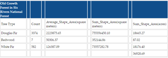
Figure 1 .
Results Table |
|||||||
|
Results Of the
three tree types, most of the old growth vegetation was Douglas Fir. There was a lesser amount of old growth
white fir. Lastly a small amount of old growth redwood trees by the Oregon
border. I summarized the area of all three tree types and found that there
were almost 37,000 acres of old growth Douglas Fir, Redwood and White Fir
forest in Six Rivers NF. |
|||||||
|
Figures
and Maps
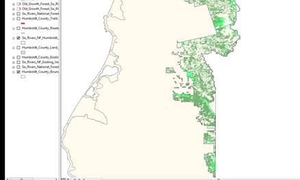
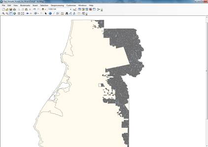
Figure
3. North West Forest Plan- Late Successional/Old Growth Data with in Humboldt
County
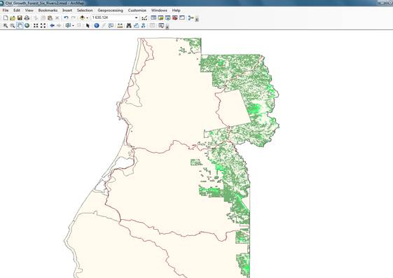
Figure
4. Spatial Join of Late Successional/Old Growth and tree type vegetation. |
|||||||
|
Analysis I initially had difficulties with
the projection of the shape files. Most if not all of the Humboldt County
data is in NAD 27. U.S. Forest Service
Data is in NAD 83. A warning did pop up in ArcMap but did not hinder the
features being displayed together. I
also struggled with acquiring relevant data. A significant portion of my time
was spent researching and combing through the metadata. Even the late
successional/ old growth data that I acquired through the North West Forest
Plan took time to find. Once I downloaded the data and added it into ArcMap,
I needed a separate data dictionary to understand the attribute fields. The
metadata unfortunately was not helpful in that regard. I was lucky to find a pdf through the
website. Overall The map reinforced that in
the Humboldt County portion of Six Rivers, Douglas Fir is the most dominant
tree type. Because of the spatial join, there are some issues with how
accurate the resulting map is. There
was some data lost. |
|||||||
|
Conclusions It’s clear that there is value and
importance in Old Growth Forests. Not just in tree species longevity but the
overall biodiversity and health of the habitat that they are a part of. Unfortunately,
a large part of those Forests have been lost through development or
environmental factors. There are steps being taken to ensure their survival. With this project there is room
for improvement, ways to reach a more accurate map of old growth. I think the
next steps that can be taken would be to do a map of the whole Six Rivers NF.
Keeping all the tree types instead of querying out the ones chosen for this
project. Then spatial joining that
data with the late successional old growth polygon and comparing that area
the estimation of 137,000 acres of old growth. |
|||||||
|
References A
History of the Six Rivers National Forest http://www.foresthistory.org/ASPNET/Publications/region/5/six_rivers/contents.htm
2016.12.08 Beardsley,
Debby, and Ralph Warbington. "Old Growth in Northwestern California
National Forest." Pacific Northwest Research Station 491st ser. PNW.RP
(1996): 1-56. Bolsinger,
Charles L., and Karen L. Waddell. "Area of Old-Growth Forest in
California, Oregon, and Washington." Resource Bulletin 197th ser. PNW.RB
(1993): 1-32. "Business
Plan for the Six Rivers National Forest." Forest Service-Pacific
Southwest Region 068th ser. RS. MB (2006): 1-49. Print Butz,
Ramona J., and Hugh Safford. "A Summary of Current Trends and Probable
Future Trends in Climate and Climate Driven Processes for the Six Rivers
National Forest and Surrounding Lands." Six Rivers NF Climate Change
Trend Assessment (2010): 1-18. "Fire
Management." U.S. Forest Service. 1-8. Print. FRAP
Mapping. CAL FIRE. http://frap.fire.ca.gov/data/frapgisdata-subset
. 2016.12.07 Waddell,
Karen. "PNW-FIADB User’s Manual." Forest Inventory and Analysis
(2013): 1-271. Print. Geospatial
Data http://www.fs.usda.gov/main/r5/landmanagement/gis
2016.12.04 Humboldt
County GIS Data Download http://humboldtgov.org/276/GIS-Data-Download
2016.12.04 Old
Growth Forests in the Pacific Northwest, USA. Conservation Biology Institute.
https://databasin.org/galleries/90e11cbab3724db2aa801e67643d9151
2016.12.07 Six
Rivers National Forest. U.S. Department of Agriculture, Forest Service. http://www.fs.usda.gov/srnf/ 2016.12.01 "Six
Rivers National Forest- Land and Resource Management Plan." (2013):
1-45. Print USGS
Earth Explorer. https://earthexplorer.usgs.gov/
2016.12.11 |
|||||||
|
|
|||||||