|
Title |
|
|
Author Name:
Vincent Campa |
|
|
Abstract My
hometown had a need for a map of their community. An image depicting the structures, water
sources and homes for firefighters to use, to better help protect the
habitants. After nearly missing the recent FEMA disaster, Butte Fire their
not out of the preverbal woods yet as the pine-bark beetle infestations
increase. A geodatabase was created containing clipped features, spatially referenced
with metadata that will help a firefighter navigate the district increasing
both their safety, and the safety of the community. |
|
|
Introduction Oftentimes, when a catastrophic wildfire occurs many of
the resource available come from outside the area, and may have little to no
knowledge of the community afflicted. The West Point Fire
Protection District, a small, mostly volunteer fire department in rural
Calaveras County had a desire for spatial analysis depicting structures,
water sources and access between the two features throughout the district. |
|
|
Background Last year the County of Calaveras was devastated by the 70,000 acer Butte Fire that burnt 2/3 of the area, yet left the small community of West Point unscathed. Like many small communities occupying the wildland urban interface in the foothills of the Sierra Nevada, they are currently loosing much of the forested land to the Pine Bark Beatle infestation, leaving lots of dead fuel available for a future catastrophe. |
|
|
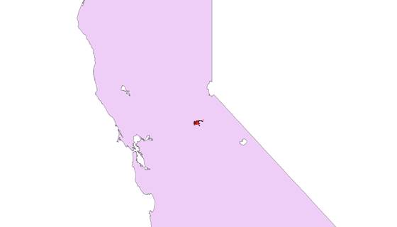
CalFIRE has begun to map, and provide for some units within California Pre-Fire Contingence data pertinent to firefighter safety, including: water sources, electrical hazards, dangerous roads etc. Pre-Fire Management maps produced by CalFIRE of San Luis Obispo have been use as a template for this project in particular: Structures, water sources and roads. (see: http://www.calfireslo.org/PreFire_GIS.html) 2016 -West Point Fire Protection District in red- |
|
|
Methods Most
of the data acquired for the map came from the Calaveras County GIS
department from FTP files via the internet.
I searched mainly for data that would fit into the .bat framework, and
found transportation in the form of Roads_2013, Hydrography in the form of
River and Waterbodies, govUnits in the form of County_Boundary and FIRE_DISTRICTS, Elevation in the form
of Contours_200ft, Cadastral in the form of PARCELS, and orthoImagery
that covered the desired extent. For GeodeticControl I used point features from the Public
Land Survey System from BLM. In
addition, I acquired fire hydrant data in CAD file form from the Calaveras
County Water District under conditions of a non-discloser agreement and
placed under hydrography (.drg
converted to .shp). |
|
|
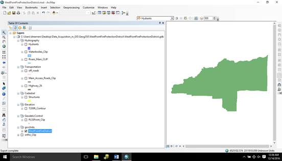
All
data was staged in a file system under the .bat framework, then introduced
into a file geodatabase in ArcGIS. All
of the data was spatially referenced into NAD83 State Plane California
FIPSIII, and metadata introduced. Once
in the .gdb filesystem the
data was then loaded into a map and clipped to the extent of the fire
district with some feature classes further geoprocessed. For instance, Transportation was broken
into 3 separate subgroups, and Cadastral was attribute selected for parcels
containing structure values greater than $10,000. |
|
|
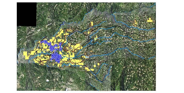
Results The finished map depicts 109 fire hydrants (in blue), 1284
parcels with structures on them (yellow), covering the West Point Fire
Protection District. |
|
|
Figures and Maps
|
|
|
Analysis The
ratio of structures to fire hydrants at first glance appears to be quite good
reduced roughly to 10:1 however, upon further analysis of the map one quickly
sees that the hydrants are mostly concentrated into one location leaving
homes on the outskirts of town more susceptible to fire damage. This
information along with other hydrography features on the map will help the
fire department develop potential drafting spots that could be used to refill
water tenders without having to return all the way back to town saving
precious minutes. The
challenge still lies in knowing where to locate specific structures on
parcels, further exacerbated knowing that some parcels are quite large, some
containing many buildings. Further
analysis is required to tease out this data. |
|
|
Conclusions The
primary advantage of this map is in the ability of visiting firefighter to
quickly and accurately navigate this unfamiliar area. This can not only serve to the benefit of
the local community, but perhaps in some instances aid in the safety of those
putting themselves into harm’s way.
That said, more work is needed to better depict the most precious commodity
in available sources of water and represented structures. |
|
|
References http://www.calfireslo.org/PreFire_GIS.html last accessed 2016.12.11 |
|