GIS in
Archeological Applications From a Cultural Perspective
By
Der Hsien Chang
American River
College
Geography 350:
Data Acquisition in GIS; Fall 2016
Abstract
Artifact identification is paramount in
understanding a site and the human history that evolved from it. Archeological applications on a site using
GIS aids the archeologist in proper identification and interpretation of the
artifacts. In particular, Chinese
artifacts are sometimes mis-identified and mis-categorized due to the lack of
understanding of exactly what this artifact is and where on a vessel it comes
from. This paper will address in detail
how GIS is helpful in the archeological investigation process.
Introduction
One of the most important aspects of archeological
work is attempting to reconstruct the past by systematically removing and
recording layers of dirt, material culture, flora and fauna samples, and soil
content. In the past, the recordation
were mostly descriptive in nature. In
the instance of artifact identification and interpretation, there did not exist
a process to generate a 3 dimensional presentation of the artifact provenience
whereby these items could be mapped after their removal. This shortcoming had led to
mis-categorization and misunderstandings of Asian ceramics in the analysis process
thereby leading to inaccurate interpretations of the archeological site(s).
Background
Generally speaking, Asian historical artifact
compilation is not a topic taught in the archeological field work. The misidentification and mis-categorization
of Asian artifacts is often found in the archeological literature (Chang
2006). There did not exist a technique
to which ceramics could be mapped spatially in 3-D such that the tabular data
gathered in the field could be viewed alongside the spatial representation
until GIS. The GIS process captures the
snapshot of the artifact in its original location in the field prior to removal
to provide much more detailed information that would otherwise be lost or
shuffled away once the field work was completed. This paper discusses the
concept of using GIS to provide a more precise interpretation of the Chinese
ceramic assemblages in the context of an archeological site.
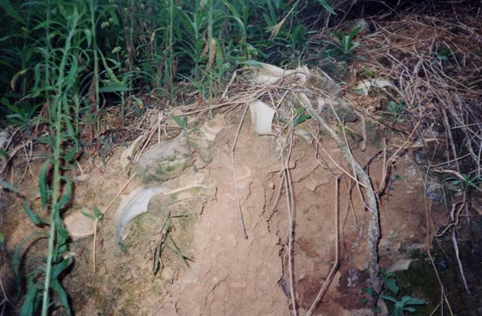
Figure
1 Kiln waster pieces from an
archeological site in Hong Kong
Methods
With the application of GIS (ArcMap), an archeologist
has the ability to have side by side a tabular descriptive and quantitative
report alongside a spatial representation of that information at their
disposal. This advancement in viewing data
from two different vantage points allows the archeologist to not only see in
3-D through the spatial side, but also conduct analyses through the tabular
side seeing each layer of material culture contained in specific recorded depths
of soil. This process explicitly sheds
light on human behaviours of the past.
Results
For a specific example, let’s turn to the widely
distributed “Four Seasons” pattern Chinese ceramics. This particular type is found in Oregon, Washington,
and California in mining sites, labors’ camp and in Chinese communities from the
1860’s and onward (see Chang 2006, Farncomb 1994, Felton et.al, 1984). The Four Seasons pattern tableware set is
unique in that there are at least 7 particular individual pieces within this
setting: wine cups (2 sizes), tea cup, small plate, large plate, soup bowl,
soup spoon, and serving bowl. This
specific motif tableware has been found at sites locally in Auburn, Loomis, and
Woodland in various tableware sets (see Farncomb 1996, Felton et.al.1984).
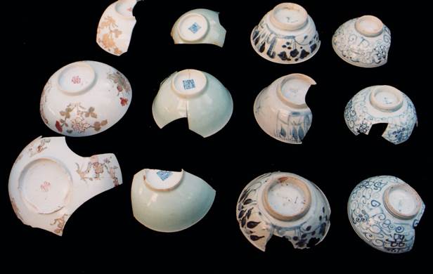
Figure
2 Excavated Chinese ceramics from Virginiatown
site
Analysis
The various arrangements of the Four Seasons tableware
set implies several kinds of possible settlements at that location: migrant
camp, temporary camp, community settlement. Each of these settlements are
different in terms of the purpose, the length in terms of time, and even
possibly the number of people in the group.
With just a description, a list showing minimum number
of units of sherds of ceramics or even just a count of the sherds does not
provide a visual representation of the artifacts in both their original
provenience prior to removal in the field nor provide a description that could
immediately visually correlate to the spatial data at hand (Felton et.al,
1984).
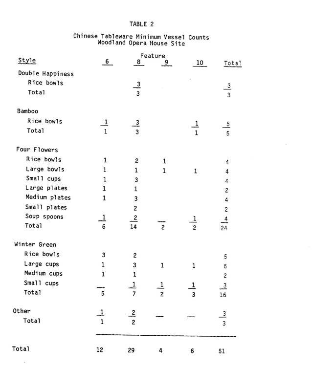
Figure
3 Woodland Opera House Ceramic Count
Presently with the same data noted above, utilizing
ArcMap and file geodatabases, it becomes a 3-D visual map with different layers
of dirt and within each layer, one can clearly see the ceramic sherds within
the dirt prior to removal. Clicking on
the individual layer on ArcMap, one can then bring up the tabular data that
corresponds to that specific layer of dirt.
This ability to view both a tabular data and a spatial data in one
screen makes it that much more easily to conduct analyses, comparisons, or
interpretations of the ceramics in question.
The various Four Seasons tableware sets are complicated to identify
especially when the pieces are small during excavation and brought back to the
lab for processing and categorizing. The
task of identifying the sherds and where on a piece of ceramic it belongs to
can be a daunting task if there are many pieces in a tableware set. However, with the mapping tools available in
GIS, one can clearly identify the layer that this piece was born from (spatial)
as well as know the exact description of that piece of ceramic such as the
body, the lip, or the base (tabular).
Conclusion
The concept presented in this paper is that using GIS
in archeology, especially in mapping ceramics, Chinese ceramics, commonly
distributed in archeological sites across California have simplified the
process in the identification and analysis phase of archeological work. Without the spatial representation of the
ceramic “in situ” and the tabular data corresponding to the layers of dirt, the
paper field documents really provide only a 2-D view of the static site. In the static view, information can be lost,
disconnected and even mis-interpreted.
GIS brings the archeological site into a visual perspective by
illustrating the layer by layer view of what is happening out in the
field. This is a powerful way to record,
view and convey data.
References
Chang, Der Hsien
2006 Ch’ing Dynasty Chinese Porcelains in California. M.A. Thesis.
Department of Anthropology, California State University, Sacramento.
Farncomb, Melissa K.
1994 Historical and Archeological Investigations
at Virginiatown: Features 2 and 4 M.A. Thesis.
Department of Anthropology, California State University, Sacramento.
Felton, David L., Frank Lortie, and Peter D. Schulz
1984
The Chinese Laundry on Second Street:
Archeological Investigations at the Woodland Opera House Site. California Archeological Reports No. 24.
Sacramento: California Department of Parks and Recreation.