| Title Red Sesbania Study McClellan Park West Nature Area Preserve | |
|
Author Gary Yuki American River College, Geography 350: Data Acquisition in GIS; Fall 2015 Contact Information gyuki9723@gmail.com | |
|
Abstract This project evaluated and cataloged the extent and range of Red Sesbania at the West Nature Area Preserve at McClellan Park along Don Julio Creek in November 2016. The purpose of the project was to establish a baseline of the extent of Red Sesbania to understand the spread and aid future studies and mitigation efforts. | |
|
Introduction | |
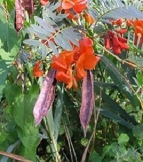 © Pancradio Campagna |
Red Sesbania (Sesbania punicea) is a small ornamental invasive plant has spread to the wildlife preserve at McClellan Park. Also known as rattle box, this small tree has beautiful red flowers and seed pods that make noise if you shake them. This plant is poisonous and crowds out native species in riparian areas. This plant is originally from South America and has been thriving in the wetland areas of the West Nature Area nature preserve. A survey is needed to map the areas impacted. Can the impacts be characterized with gps surveys, aerial photographs, or other means? A completed survey can be used as a benchmark to measure future changes in the extent of Red Sesbania habitat and help direct future mitigation efforts. |
|
Background Origin: Red Sesbania is native to South America and was introduced to the United States as an ornamental plant. (DiTomaso, Kyser, et al, 2013) Impacts: Red Sesbania grows rapidly forming dense monoculture areas displacing native plants. Large stands of Red Sesbania can impact storm water flow, contributes to bank erosion and displace native plants and animals. (DiTomaso, Kyser, et al, 2013) Habitat: This plant grows in riparian corridors with moist soils. (DiTomaso, Kyser, et al, 2013) It prefers a Mediterranean climate with dry summers and wet winters. (CABI, 2015) Control: Herbicide and mechanical removal is the recommended method of control (DiTomaso, Kyser, et al, 2013) Cal-IPC (California Invasive Plant Council) Inventory rating: High – meaning this species has a severe ecological impact on the ecosystem. (CABI, 2015) Red Sesbania is a small tree that grows to 12 feet tall. The flowers are showy red and are 0.5 to 1 inch long. The seed pods are very distinctive with a 4 winged pod, oblong, 2 to 4 inches long and often dispersed by water where. There are indications that seed pods are viable for 3 years. The plant and seeds are toxic when ingested. (DiTomaso, Kyser, et al, 2013) There have been efforts by the Sacramento Area Flood Control Agency to control and restore sections of the Dry Creek watershed beginning in 2004 with funding from the California Department of Water Resource Flood Protection Corridor Program. (Robinson R., 2012) Maintenance phases were initiated in 2007 through 2011. The areas where efforts were focused were just north of McClellan’s West Nature Area. 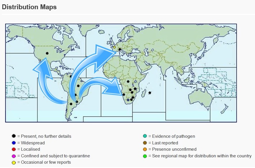 Red Sesbania, World Distribution Map Invasive Species Compendium 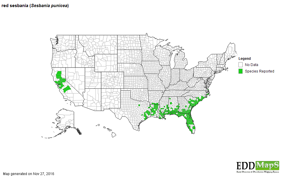 United States Distribution of Red Sesbania - Early Detection & Distribution Mapping System 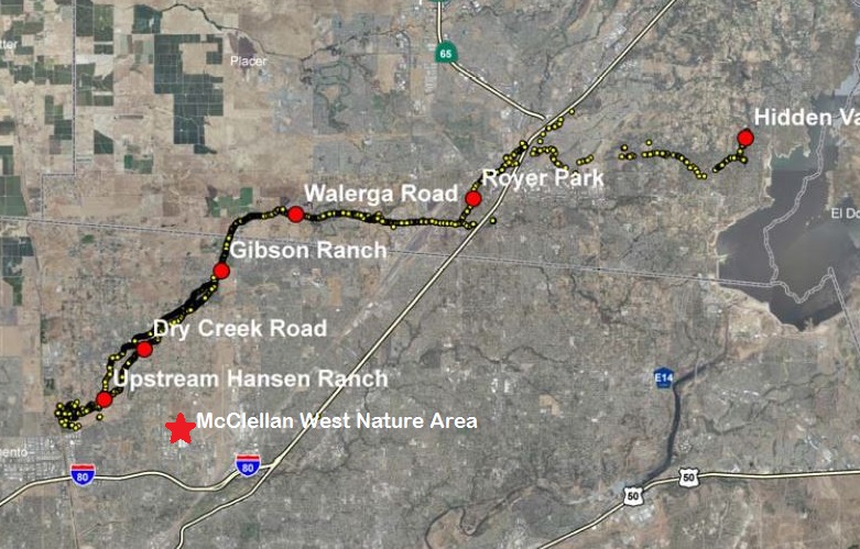 Local Mitigation Efforts - Sacramento Area Flood Control Agency, 2011 | |
|
Methods Data for the location of McClellan’s West Nature area began with collecting aerial imagery from the USGS National Map website. Additional layer for wetland habitat was collected from McClellan’s wetland mapping completed in 2013. Collection of the location and extent of Red Sesbania was completed through the use of a handheld gps (Trimble GeoXH), laser range finder (Simmons Volt 600) and smart phone (Motorola Droid Turbo). Geotagged Photos were collected through the phone camera using MediaMapper application. Two paper maps were plotted (HP Designjet 5500ps) with 20 foot grid coordinates on an E sized print that covered the survey area. The grid locations could be referenced by geographic coordinates obtained from the handheld gps. The maps were used to use to hand plot larger areas of plant growth and as a field quality check of collected gps readings. In addition to collecting geographic information, the plant growth characteristics were collected by rating the abundance and habitat. (Cary Institute of Ecosystem Studies, 2009) Abundance of the invasive plant: • Single plant • Scattered single plants • Dense monoculture (many plants grow together in one large patch or clump) • Scattered dense patches (many smaller patches or clumps of plants Habitat type: • Wetland • Creek Bank • Wetland edge • Field 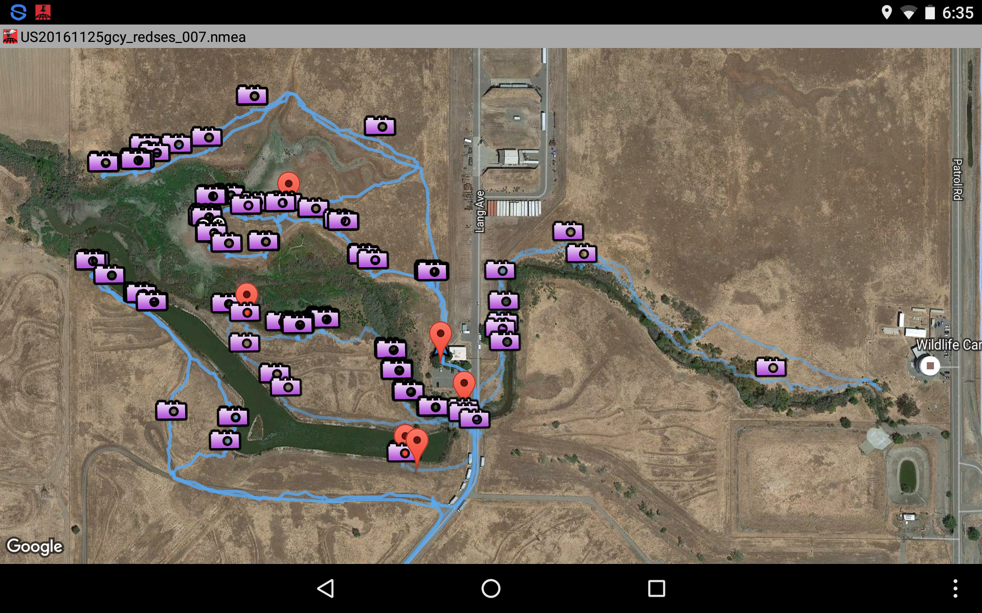 Mapping and Survey Tracks 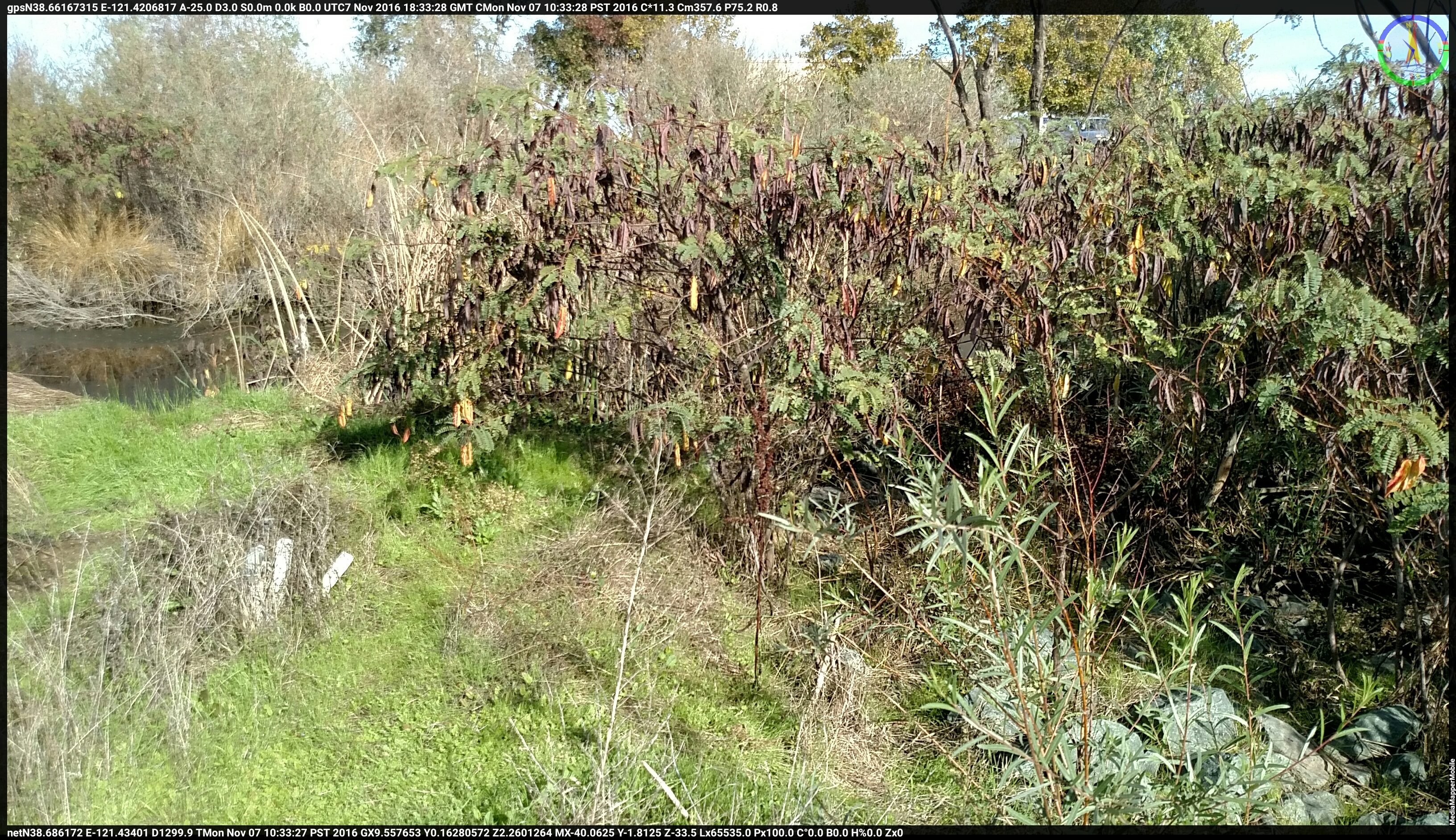 Typical Geotagged photograph of Red Sesbania | |
|
Results Twenty Five acres were surveyed for the extent and spread of Red Sesbania over three visits in November 2016. The mapping data and geotagged photo logs will provide a baseline for future study and management of the invasive species at McClellan’s West Nature Area preserve. Red Sesbania covers approximately 2.2 Acres.  Summary of Plant Survey |
Survey Map McClellan West Nature Area Preserve. Red Sesbania areas are highlighted.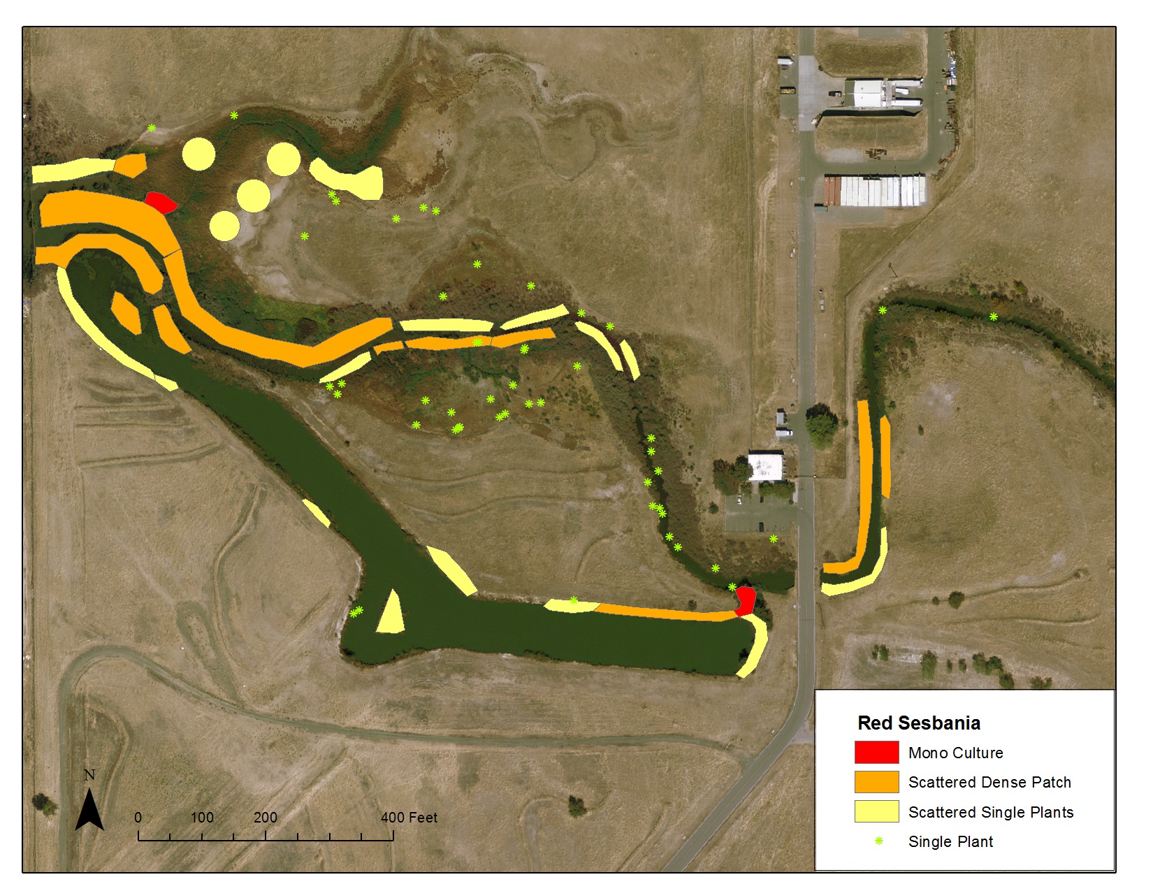 Plant Survey Map |
|
Analysis Mapping and geotagging photos were difficult with winter conditions in the wetland areas. The water levels are at the highest during these months especially after significant rain. Mapping plants inside wetland areas posed a significant obstacle. Many of the mapping points were in standing water. The data was collated from areas outside of the wetland by creating offsets using a laser rangefinder and compass readings. The laser range finder was consumer grade and compass readings were obtained from a smart phone. Although, these readings appear to give reasonable locations when checked for accuracy with the printed maps, there were occasions where there were noticeable and significant errors. A better approach would be to survey during the dry season to more accurately measure the locations and areas of plant growth nearer to the plants. Red Sesbania is easy to spot with its brown seed pods during the winter. It may be easier to locate these plants with aerial photography during late spring or early summer, perhaps using drones, to take advantage of the red flowers these plants produce in mass during the flowering season. | |
|
Conclusions A baseline of the Red Sesbania infestation was completed as part of this effort. The combination of geotagged photos and mapping efforts are a good start to quantify the extent of plant growth. Further study and refinement of mapping the extent of growth is needed to help future management and mitigation efforts. A study done during the summer months would be more effective and of higher quality since there is better physical access to the plant areas during the dry season. | |
|
References DiTomaso, J. M., and G. B. Kyser, et al.. "Weed Control in Natural Areas in the Western United States." Weed Control in Natural Areas in the Western United States. Weed Research and Information Center, University of California, 2013. Web. 26 Nov. 2016. "Invasive Plant Inventory." Cal-IPC: California Invasive Plant Inventory. California Exotic Pest Plant Council Southwest Vegetation Management Association, 28 Feb. 2003. Web. 26 Nov. 2016. "Invasive Plant Survey Worksheet." Cary Institute of Ecosystem Studies. Cary Institute of Ecosystem Studies, 2009. Web. 26 Nov. 2016. Robinson, Ramona, Ph. D. "2011 Dry Creek Red Sesbania Monitoring Report." Placer RCD. Placer County Resource Conservation District, Mar 2012. Web. 26 Nov. 2016. "Sesbania Punicea (red Sesbania)." Sesbania Punicea (red Sesbania). CABI (Centre for Agriculture and Biosciences International), 23 Oct. 2015. Web. 27 Nov. 2016. | |