| Title Increase of Agricultural Efficiency for Apple Hill with Use of Drones | ||||||||||||||||
|
Author Jennifer Carlton American River College, Geography 350: Data Acquisition in GIS; Fall 2017 | ||||||||||||||||
|
Abstract Agriculture is a time sensitive industry. Farmers must constantly be aware of their crops and growth cycles within their fields. Implementing new technology can revolutionize their management of time and resources as they maintain their crop health. With the rise of cutting edge drone advancements, they now have new options for meeting those critical elements. Thermal sensors can now be integrated onto UAVs for quick and easy access to an aerial view of fields in CIR and NDVI imaging. Through the analysis of these imaging programs, accurate assessments of plant health, stress markers, and soil contents allow farmers to know how best to care for their fields. This in turn results in better, healthier crop harvests. The tree farms, orchards and vineyards of Apple Hill, California are prime examples of just such a use. The uneven terrain and unpredictable weather make UAVs a great option for minimizing time, stress, and money on maintaining the various crop types. | ||||||||||||||||
|
Introduction California is known for being one of the biggest states in the farming industry. From nuts to fruits, many varieties of foods are grown right here in our home state. In El Dorado County, the famous Apple Hill region is a popular hot spot year round as they are known for their numerous orchards, Christmas tree farms, and wineries. Like most areas of business, agriculture has its own set of struggles and problems it faces throughout the year. Many are unable to be controlled such as the weather. Sharp changes in forecast can be the end to many crops if not paid attention to or handled correctly. However, there are difficulties that can be greatly improved upon. These include, but are not limited to, the expense and time it takes to maintain agricultural grounds. Within the past decade, the introduction of new drone technology has proven to be invaluable in this regard. Therefore, we will be examining aerial imagery and discussing several the problems that drones could solve in Apple Hill’s farming industry. |
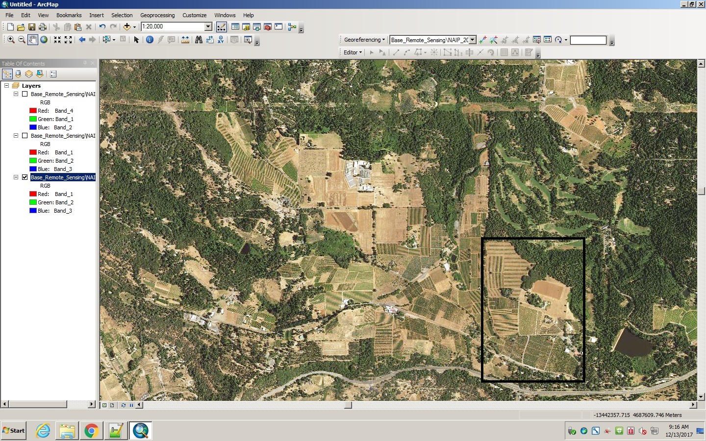
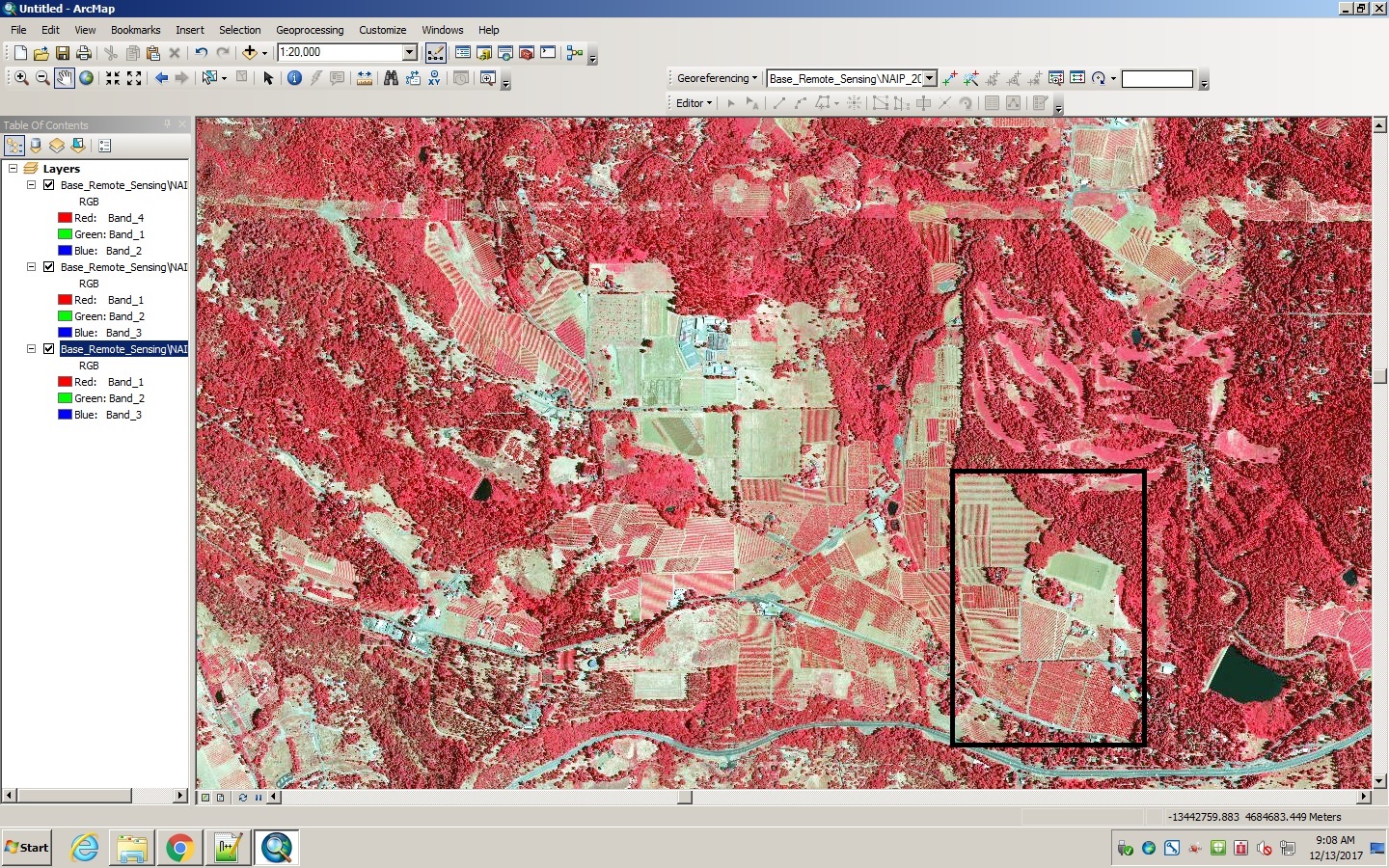
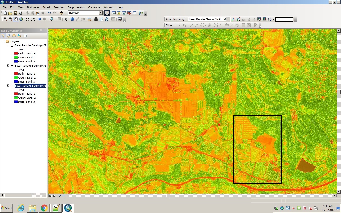
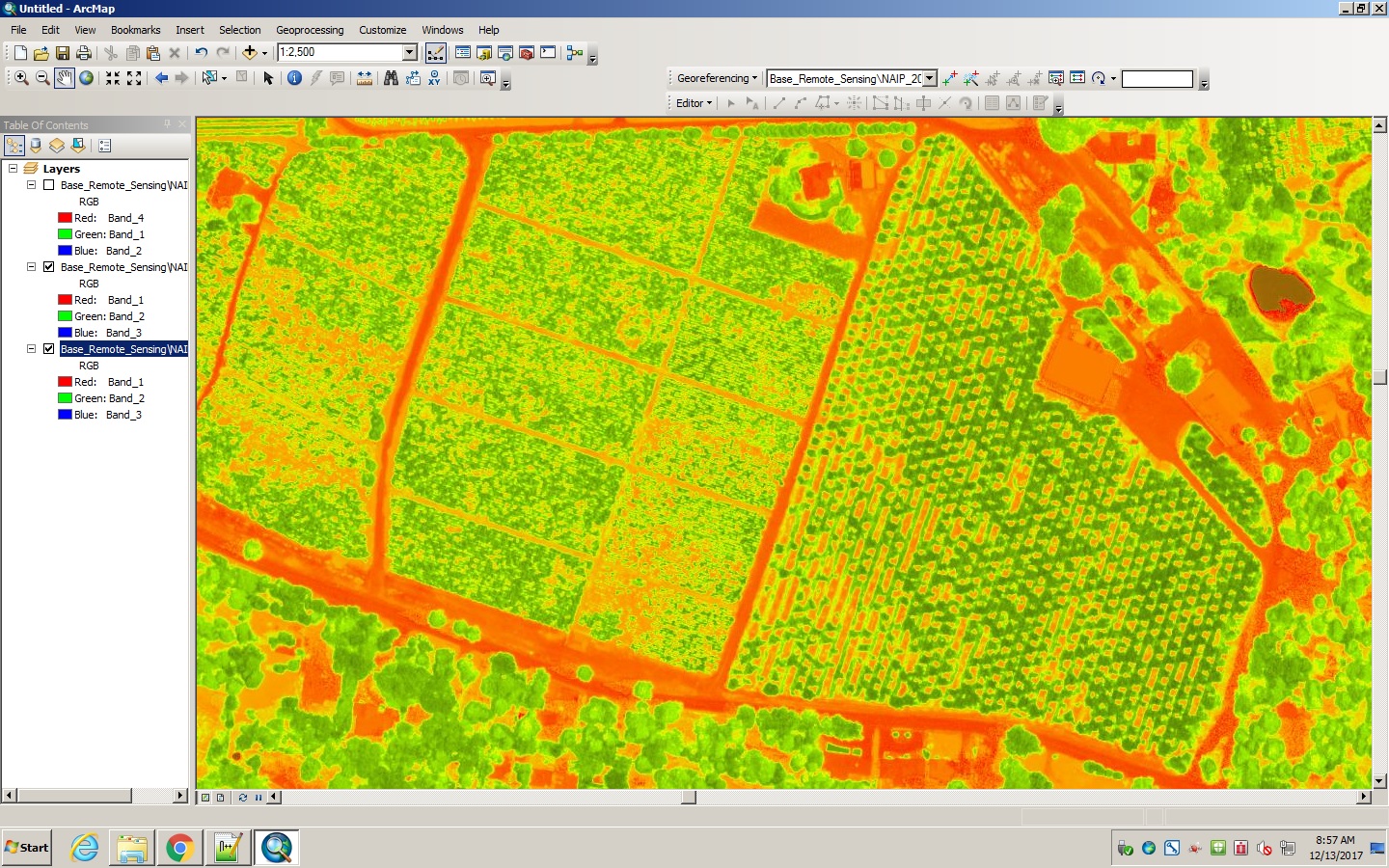
Background Already, Color Infrared (CIR) is an invaluable asset to crop analysis. It detects wavelengths emitted by plants that are outside of a human’s visible range and can capture clearer imagery through the atmospheric haze. Also, the Normalized Difference Vegetation Index (NDVI) imaging, developed through CIR, is a measurement that “takes into account the amount of red energy that is absorbed by chlorophyll and the amount of near-infrared energy that is reflected by the cellular structure of the leaf (because the red and near-infrared measurements are normalized in an indirect measure of vegetation health)” (USDA, 2013) These aerial datum provide large amounts of data that can be used for a wide variety of analyses. Color Infrared (CIR) displays healthy vegetation in bright red. Different shades of red can indicate various forms of stress on a plant such as lack of fertility, malnutrition, insects, and over or under watering. (USDA, 2013) The ability to gather this type of information from a fly over the fields is an incredible aid in crop monitoring. Now, UAV’s (Unmanned Aerial Vehicles), or drones, are equipped with this technology and are a significantly more cost efficient way to track crop health. Not only are they cheaper to fly than a traditional airplane equipped with sensors, but they are easier and faster to gather data with as they can be flown as needed providing up-to-date information. The images below show the differences in each imaging system on the same Apple Hill geographic area. The boxed areas are the specific farms we will use for analysis later in the project. The first image shows the natural color NAIP (National Agriculture Imagery Program) aerial. The second image displays the CIR imagery where heat and energy emission from vegetation are represented on a red scale. Lastly, the third image shows the NDVI imaging where the green end of the scale represents more energy emitted and the red represents little to no energy emitted. |
|||||||||||||||
| ||||||||||||||||
| ||||||||||||||||
| ||||||||||||||||
|
Methods I was able to collect data from El Dorado County's GIS department of NAIP (National Agriculture Imagery Program) for use of CIR and NDVI datum for California. While the data being used was not collected via a UAV, it shows the types of work that sensor-equipped drones can produce. Quadcopters are a typical choice when deciding on an affordable yet reliable UAV. Most quads come equipped with a 4K video camera. Depending on other specifications, a thermal sensor can be added on if one is not already built in. For instance, the FLIR Vue thermal sensor is a fairly inexpensive yet high quality option for users not needing extremely high precision accuracy. This makes it a very effective option for agricultural purposes. | ||||||||||||||||
|
||||||||||||||||
|
We will be looking at the different types of thermal imagery mentioned above and discussing how that type of data, having been captured with a drone, could solve many different problems found in agriculture. The ability to easily have an eye in the sky would be a huge asset to all farmers. Each of the different types of imagery reveal different types of data information to the analyst and can provide growers with detailed knowledge and advance warning regarding crop issues that can arise. | ||||||||||||||||
|
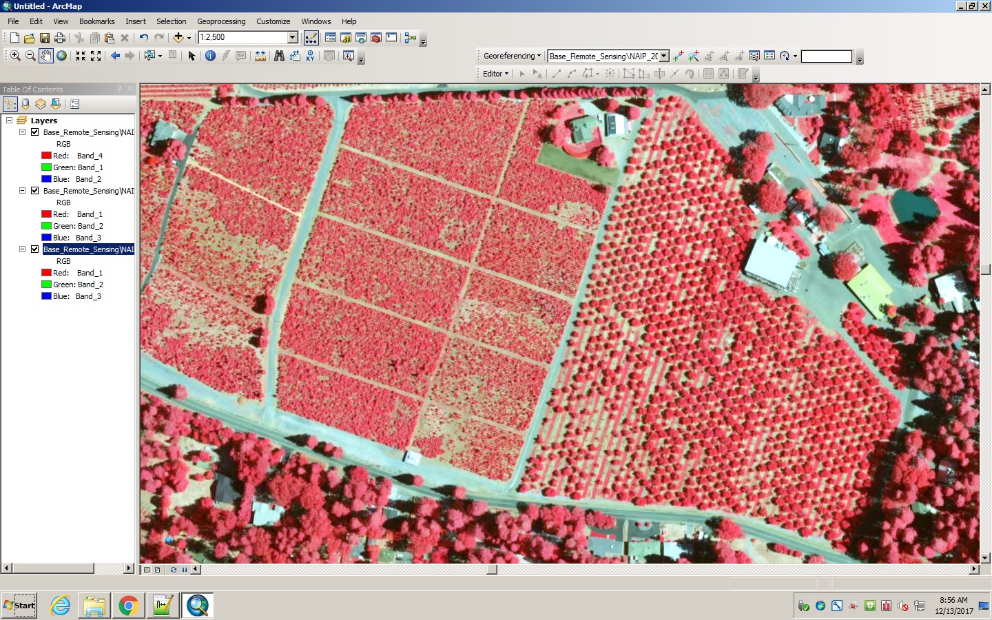
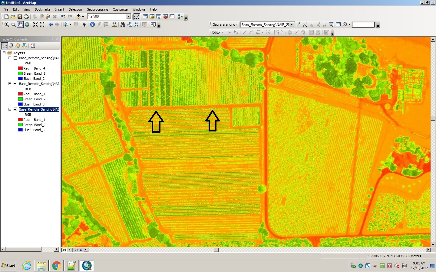
Results The first example we will look at is McGee Christmas tree farm and the neighboring High Hill Ranch. On the left side of the CIR image below, McGee Christmas tree farm can be clearly seen by the major clustering of trees on the farm. It is a great example of how drones could remedy time and costs on the tree farm. First, due to the uneven terrain of this region and the large amounts of snow that can hit during the winter time, having an airborne view of the farm can quickly help farmers know the health of the trees, plan planting patterns, and track the regrowth from “stump culturing” for the next year’s season of Christmas tree cutting. Using their naturalized vegetation index, they can always be aware of and act on any potential threats to their trees. On the right side of the image can be seen one of the orderly apple tree orchards of High Hill Ranch. Similarly to the Christmas tree farm, the use of a sensor equipped UAV in the orchard would be a huge asset to the farm as consistent scanning allows farmers to keep track of tree health. If change takes place such as stress on a plant, the vegetation will reflect different amounts of green light and near-infrared (NIR). Fruit farmers must always be on guard against pests as well as tree fungus and bacteria. Any number of potential threats to their orchards could mean a serious loss of income. | ||||||||||||||||
| ||||||||||||||||
|
In CIR, the intense, brighter red representations show dense, healthy growth in vegetation producing large amounts of chlorophyll. The lighter, pinker colors can show either evergreen type trees (less leaf surface area to emit chlorophyll energy) or an leaf-off season time period, such as winter. Other colors (i.e. tans and blues) show differences in soil types. The variations in shade reveal the percentages of sand, silt, and clay in the soils. Aronoff (2005) As plants absorb solar radiation (visible light) in photosynthesis, they also reflect solar energy (near infrared). Thus, “NDVI is an index which measures this [absorption] difference, providing a measure of vegetation density and condition. It is influenced by the fractional cover of the ground by vegetation, the vegetation density and the vegetation greenness. It indicates the photosynthetic capacity of the land surface cover” Bureau of Meteorology (2017) | ||||||||||||||||
| ||||||||||||||||
|
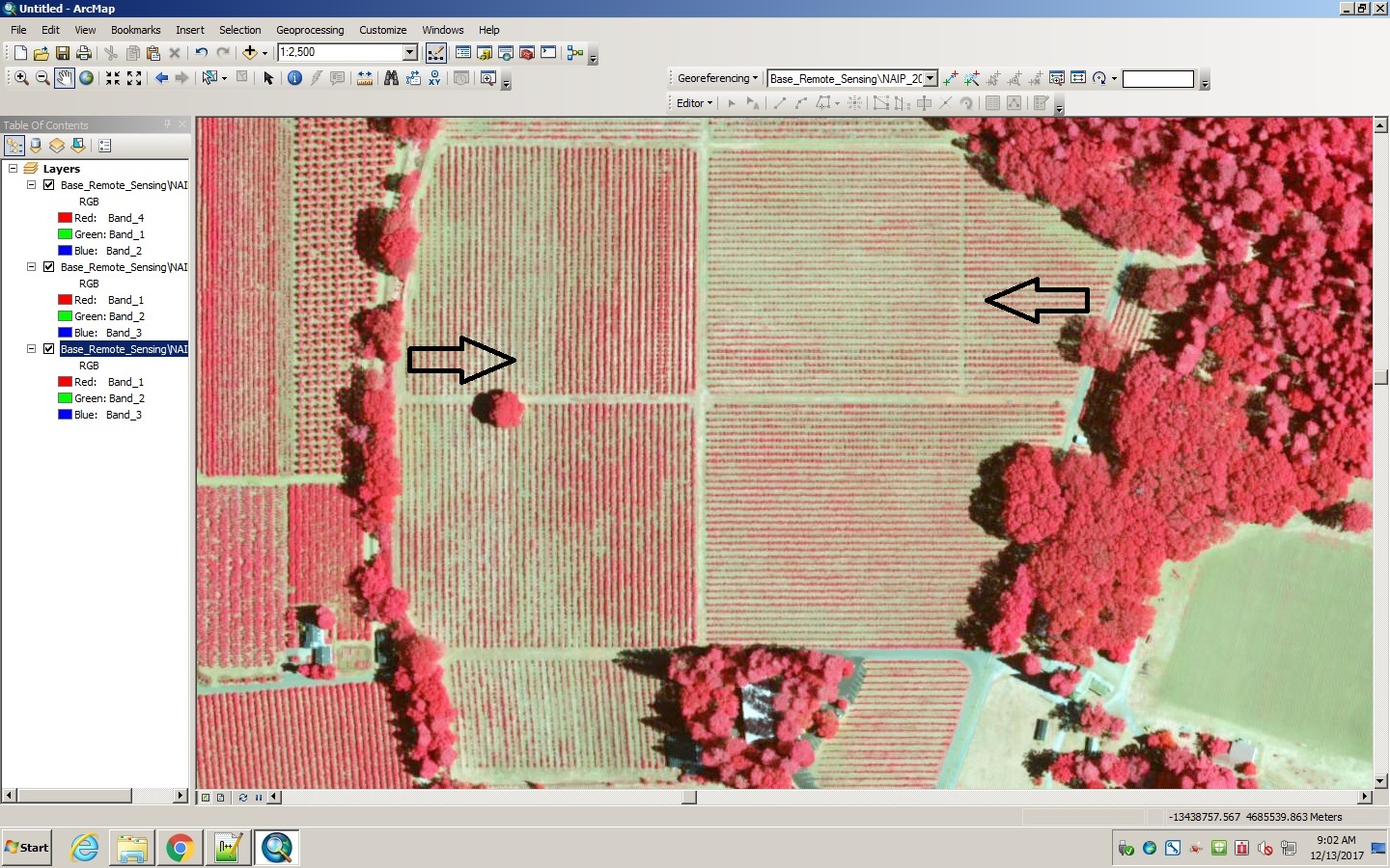
Another common example of agriculture in California are grapes. Wineries can be found all across the state including in the Apple Hill area. For example, Madrona Winery lies just north of High Hill Ranch and McGee Christmas Tree Farm. More often than not, certain fertilizers and/or pesticides are needed in creating a successful harvest for wineries: “…experts estimate that aerial spraying can be completed up to five times faster with drones than with traditional machinery” Mazur (2016). They allow for crops to be sprayed that otherwise would be difficult for the tractors to reach. This is especially true on the uneven terrain found in Apple Hill. Another important factor in vineyards, and all agriculture in general, is proper irrigation. Drone mounted sensors can detect soil moisture and alert the farmer to any areas needing more or less watering. In the example below, the drone CIR would provide growers a clearer view of the various stages the grape vines are in. Whether they are growing properly or whether they are losing their leaves for the changing seasons, farmers can always be aware of the progression of growth cycles across their vineyards with ease. This can help with planning planting season, fertilization needs, as well as harvesting time. The arrows in both images of the upper and lower fields of Madrona vineyards highlight the different stages of maturity and growth within the winery’s extent. | ||||||||||||||||
| ||||||||||||||||
| ||||||||||||||||
|
Analysis Because the aerial data used in this project was not collected by a UAV itself, I was unable to show specific examples of drone thermal imagery in Apple Hill. At this point in time, public NAIP imagery gathered by a drone are not as easily accessible. In addition, due to the NAIP images used in the project being taken at a much higher altitude, the image quality is not as detailed or dynamic as it would be from a low flying drone. However, the CIR and NDVI images of Apple Hill pictured above allow viewers to understand their powerful capabilities in an agricultural context. | ||||||||||||||||
|
Conclusions To farmers and growers, time is a precious commodity. Their livelihood revolves around maintaining the health of their crops and being aware of any potential threats to the plants. That is why it is important for them to implement new technology where possible so as to avoid problems that could mean the difference between a bumper crop and a lost crop. As UAV technology has integrated CIR and NVDI into their drones, they have provided an incredibly efficient option for farmers to utilize. They have provided a way for growers to have a cheaper, up-to-date, aerial view of their farms without exhausting time and resources on maintenance and surveillance. In addition to aerial images and videos of the farm land for analysis purposes, drones are a cheap way to fly over plants for crop dusting purposes as well as for business marketing. As technology continues to advance, drones may become even more automated allowing for easy operation and less flight training for agriculturalists to use. However, please bear in mind that operating any electronic equipment comes with its own set of risks. For those interested in investing in UAVs for their agricultural business, please visit Know Before You Fly and Drone Deploy for flight instructions and further information. | ||||||||||||||||
|
References Aronoff, Stan. Color-infrared (CIR) imagery. www.mngeo.state.mn.us/chouse/airphoto/cir.html. 2005. Bureau of Meteorology. Map information - normalized difference vegetation index. www.bom.gov.au/climate/austmaps/about-ndvi-maps.shtml. 2017. Corrigan, Fintan. Multispectral imaging camera drones in farming yield big benefits. www.dronezon.com/learn-about-drones-quadcopters/multispectral-sensor-drones-in-farming-yield-big-benefits/; 2017.10.17 Mazur, Michal. Six ways drones are revolutionizing agriculture. www.technologyreview.com/s/601935/six-ways-drones-are-revolutionizing-agriculture/; 2016.07.20 Morgan, Tyne. The good and bad of agricultural drones. www.agweb.com/article/the-good-and-bad-of-agricultural-drones-naa-tyne-morgan/; 2015.01.27 USDA. Four band digital imagery. www.fsa.usda.gov/Internet/FSA_File/fourband_infosheet_2012.pdf; 2013.06 vanVark, Caspar. Drones set to give global farming a makeover. www.theguardian.com/global-development/2015/dec/26/drones-farming-crop-problems-uavs; 2015.12.26 | ||||||||||||||||