| Title Mapping Invasive Plant Species On The American River Parkway |
|
|
Author
American River College, Geography 350: Data Acquisition in
GIS; Fall 2017Daniel Sullivan
Contact Information: GeoGIS916@gmail.com |
|
|
Abstract
Invasive plant species are very common and established at the American River Parkway. Combating the spread of invasive plant species takes time, effort, and high quality, up to date maps. |
|
|
Introduction
Invasive plant species are harmful to California ecosystems. According to the California Invasive Plant Council invasive species are the second greatest threat to endangered species after habitat destruction. In order to effectively control the spread of invasive species along the American River Parkway accurate mapping is required so I surveyed a section of Sailor Bar, American River Parkway for 10 invasive plant species. |
|
|
Background
The American River Parkway Foundation has an Invasive
Plant Management Program enlisting volunteers to join
Invasive Plant Patrol groups that go to The American River
Parkway regularly to identify and remove invasive
plants. |
|
|
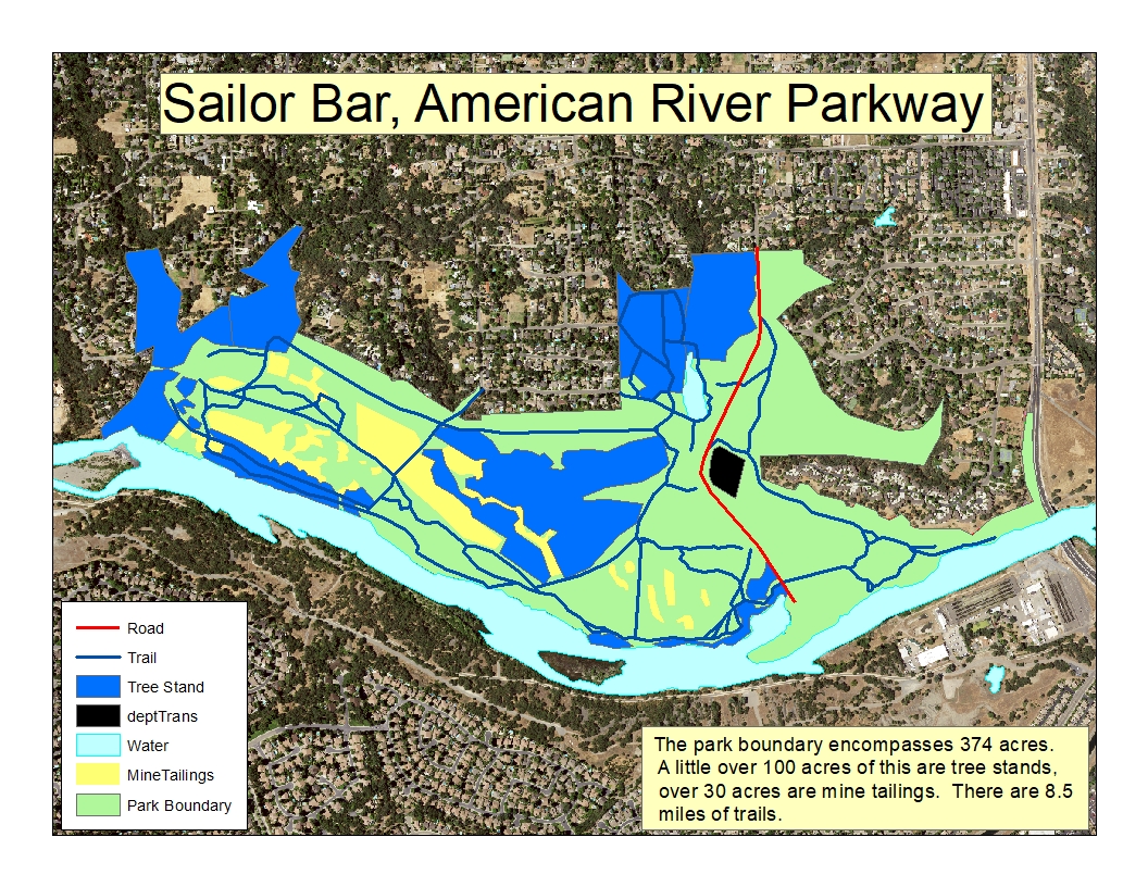
Methods
I first
acquired Sacramento County Parks and Rivers polygon Data
for my study area from the Sacramento County GIS Data
Library. I then found .6 meter pixel, 3 band (RBG)
aerial photographs of my research area taken in 2014 on
the USGS EarthExplorer for the purpose of vectorizing
park features. Because Sailor Bar was not fully
contained in a single photograph I created a mosaic from
two adjacent photos. To minimize file sizes I used the
Extract by Mosaic spatial analyst tool to create a a
smaller aerial image using the County Park Polygon to
clip my study area. Once I had my study area base
map I created a series of vector line and polygon
feature classes representing trails, roads, mine
tailings, and tree stands using the Editor toolbar for
planning the plant survey. Once my base map was
completed I physically went to the study area and walked
a section of trail taking point data for invasive plant
species. |
|
 |
|
|
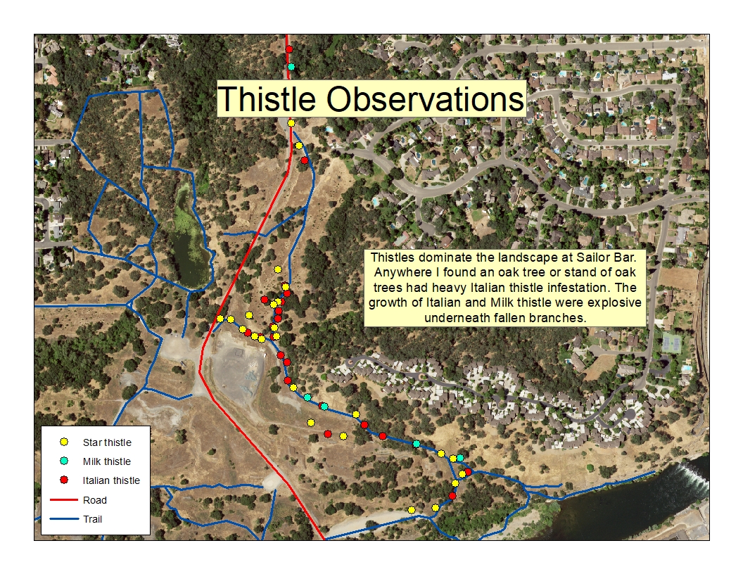
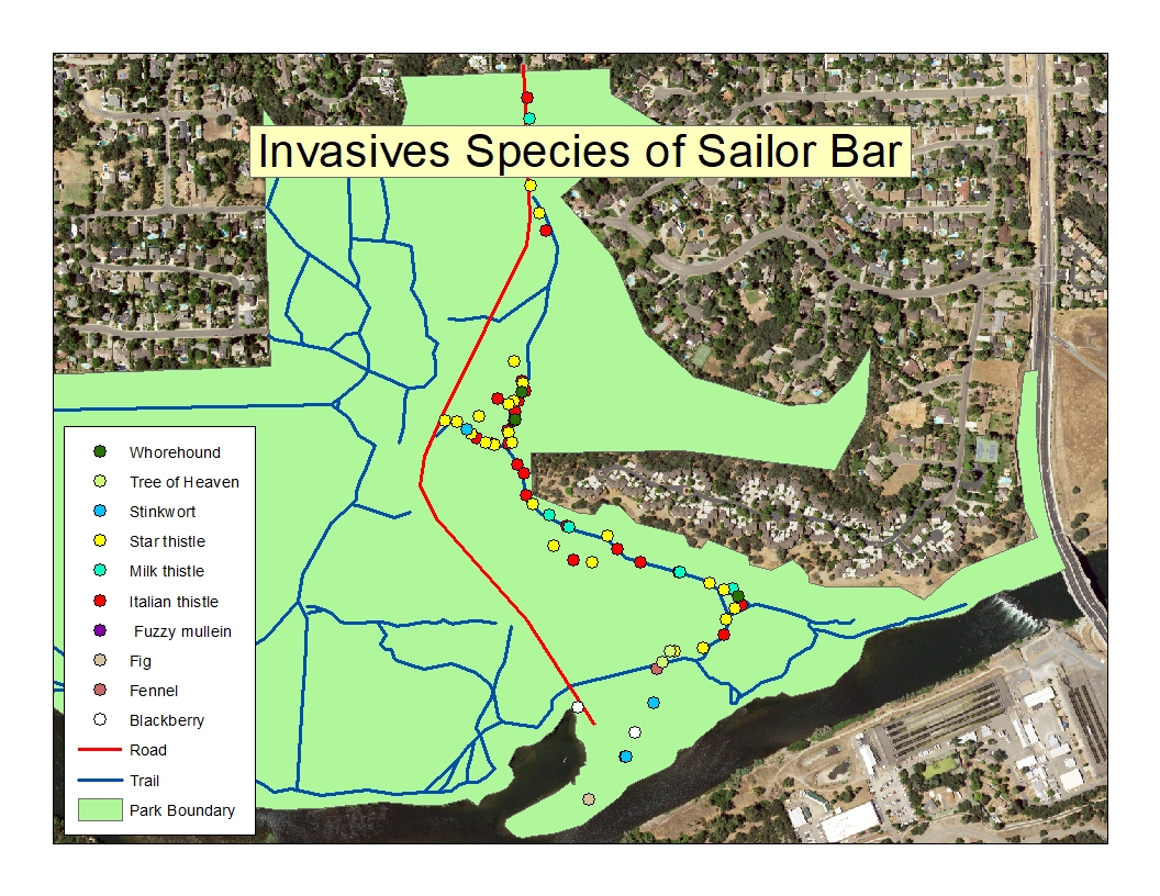
Results
Invasive plant species are by in large naturalized to
Sailor Bar. In the area I surveyed thistles were dominant
and seemed to love living under Oak canopies. The thistle
growth seems to explode under fallen oak tree branches.
Three thistles were present, the most abundant being
Italian thistle followed by yellow star thistle and milk
thistle respectively. Of the 10 selected invasive species
I selected for survey all were present at the study area
to varying degrees. |
|
|
Figures and Maps
|
|
|
|
 |
|
Analysis
The biggest difficulties I had were in identifying plants
and choosing too large of a survey area for one person to
reasonably manage. The plants I chose for survey I can
identify fairly easily but it leaves out an important
chunk of invasive species that I am not proficient in
identifying: Invasive grasses. The help of a domain expert
in identifying grasses would be essential to accurately
map the most troubling invasive species. Surveying an area
for plant species is incredibly time, energy, and resource
consuming so having a good base map and a methodical plan
are essential to efficiently collect plant survey data. |
|
|
Conclusions
To accurately map invasive species for the purpose of
eradication or controlling their population growth it
would be beneficial to form Early Detection Rapid Response
groups (EDRR) that are proficient in plant identification,
surveys the study area regularly and uses plant
eradication protocols to control the spread of invasive
species. |
|
|
References
Literature: http://arpf.org/what-we-do/programs/invasive-plant-management-program/ September 2017 Literature: http://www.cal-ipc.org/plants/impact/ September 2017 Spatial Data: http://www.sacgis.org/GISDataPub/Pages/default.aspx October 2017 Spatial Data: https://earthexplorer.usgs.gov/ October 2017 |
|