Roadblocks: Exploring a Lost Thoroughfare in Sacramento
Author Information:
Andrew McLeod
American River
College GEOG350 Data Acquisition
December 13, 2017
Abstract
An examination of geospatial data supports the existence and disappearance of an established thoroughfare southeast of Sacramento. This lost road would have provided for improved traffic flow into the present, but it seems to have been removed within a quarter century of its apparent peak use in the 1850s and 1860s. Elevation data was used to identify natural routes through Sacramento’s flood-prone topography, while modern and historic transportation and cadastral data helped confirmed the route’s existence and pointed towards a few surviving remnants.
Introduction
The Sacramento area’s modern traffic challenges include a pair of bottlenecks related to US Highway 50 (US50). These include the lack of connection northward to Interstate 80 and southwestward toward California Highway 99 and Interstate 5.
The former gap in the road system will be the subject of this project, as it appears to be better documented. In recent years, there has finally been some movement toward closing this gap with a beltway connecting Folsom and Elk Grove (Capital Southeast Connector), but that route’s great distance from the city renders it useless for most travel within the metropolitan area.
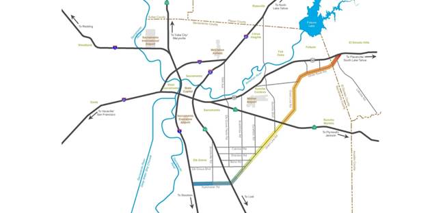
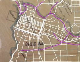
Stranger still, this gap in our road system, which has existed for more than a century, appears to exist despite the early establishment of a topographically superior (i.e. less flood-prone) thoroughfare called the Sutterville and Brighton Road. This road connected a pair of settlements that were rivals to Sacramento City – Sutter’s preferred townsite downstream, and the “Squatter” stronghold on the American river near modern Howe Avenue.
A similar gap exists between US50 and I-80, despite construction during the mid-20th century of the Elvas Avenue expressway, which bizarrely connects to neither highway. This route is further degraded by a confusing set of intersections near J Street, which has itself been reduced from its original role as a thoroughfare to the Gold Fields (formerly continuing through the modern location of CSU Sacramento and following the south bank of the American River). These gaps bear further research but are beyond the scope of the current project.
Background
I have been unable to locate any literature on this issue, which is consistent with generally poor understanding of this area’s history of land conflicts. However, the Sutterville and Brighton Road is mentioned occasionally in early newspaper accounts obtained through the California Digital Newspaper Collection (www.cdnc.ucr.edu).
The route (hereafter referred to as the SBR) also appears in several maps from the 1850s and 1860s, indicating that it was a relatively persistent route that lasted for perhaps two decades. However, there is little trace of its midsection by 1885, and in modern times its connection to the American River has been reduced to only faint traces in the cadastral data.
Methods
I compared the existing road system with idealized routes of my own creation, historic routes from a map proposing the Sacramento Valley Railroad (1855), a 1911 series USGS topographic map, and aerial imagery from 1937.
Results
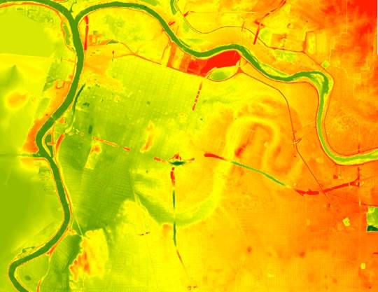
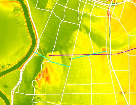
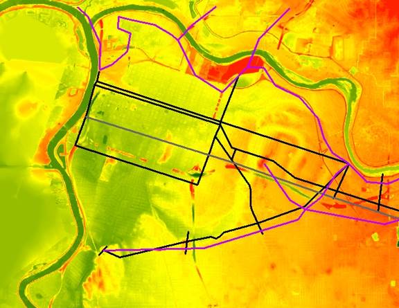
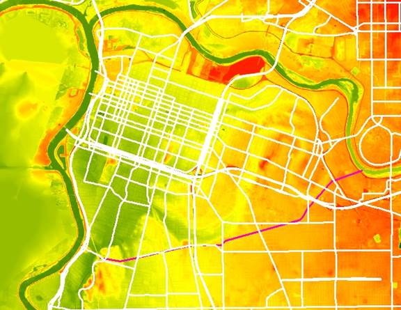
The US50 bottlenecks occur despite the lack of obstacles – indeed, the roads that survived were among the worst routes with regards to topography, making several crossings of a low wet feature formed by an ancient channel of the American River. The 3M LiDAR imagery was a fundamental source and I used it as a basemap of sorts. I also imported the modern street grid then deleted all non-thoroughfares. I also used a line shapefile of natural routes that I created based on my past research as well as reading the topography – it was assumed that a natural route would avoid low areas like the prominent ancient river channel, as they would sometimes be flooded and often be marshy and full of insects.
Here are the modern roads alongside my natural routes.
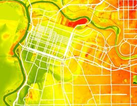
I also noted that some of the natural routes corresponded to modern roads, although with significant gaps making them unsuitable as thoroughfares. Below is a gap in Sutterville Road at Freeport Boulevard, followed by a pair of gaps in Elvas Avenue Expressway, near Folsom Boulevard and C Street.


Analysis
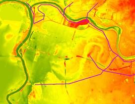
I first georeferenced the plan for the Sacramento Valley Railroad (Judah), which had the clearest and least questionable depiction of the road, including intersections and a symbol that turned out to indicate a racetrack near the modern intersection of Franklin and Sutterville Road. This corresponded somewhat closely with the natural routes I had identified, and bore little resemblance to the modern street network.
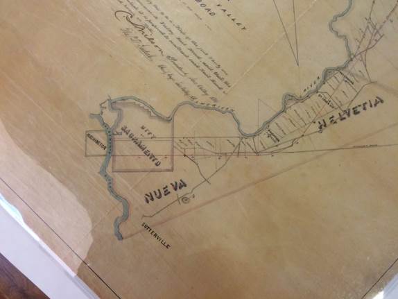
The SBR route indicated very closely resembles the natural route, but bears little resemblance to the modern road system (other than the surviving stretch of Sutterville Road).
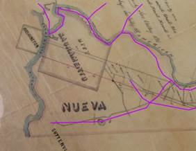
I digitized the features of the SVRR map for comparison to other data.
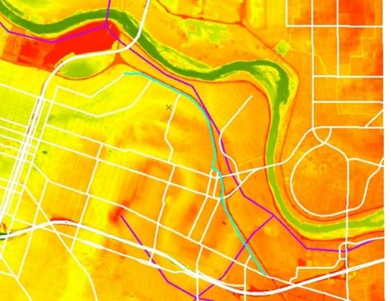
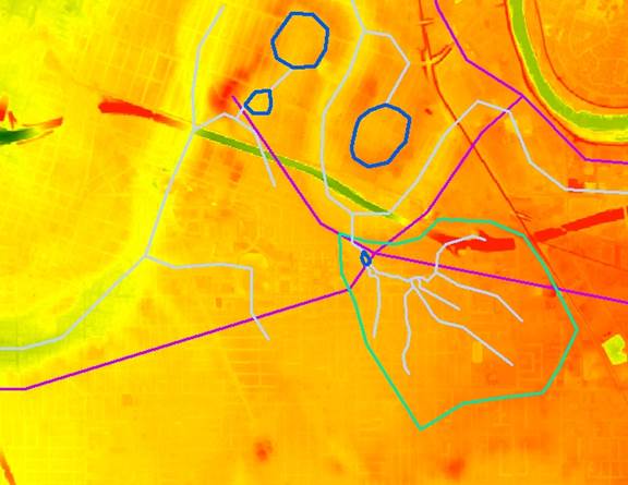
I then turned my attention to hydrology, reconstructing old stream channels (pale blue) wetlands (dark blue), as well as a watershed boundary that drained into a wetland near the intersection of two natural routes. This drainage of nearly a square mile would have created a relatively reliable water source that would have outlasted most others between the rivers.
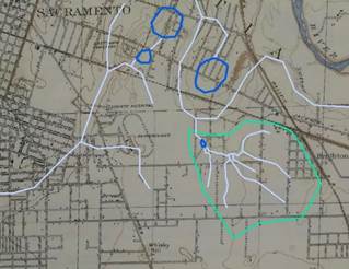
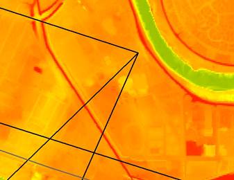
Zooming in, I turned my attention to the topo map from 1911, which I used to fine tune the stream channels. The right image is a zoomed in part of the left image, showing a diagonal road that may be a remnant.
Zooming
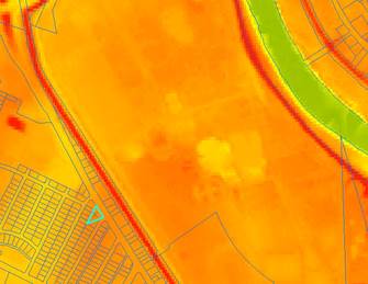
in even further, I compared the aerial imagery with the stream channels, and
confirmed that the diagonal road goes just upstream of the wetland, which would
have been an ideal spot to stop with horses.

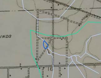
The
final stop is the eastern end, where the roads noted on the SVRR map converge
at the point at which an extended J St would meet the river. The highlighted
parcel is the southernmost corner of another rival city called Norristown, which
would have been a likely route for a thoroughfare.
Conclusion
The Sutterville and Brighton Road is still something of a ghost, but we can begin to trace its route through modern Sacramento. When compared to the modern road system, we can see that it fills significant gaps.
References
Capital Southeast Connnector. “Project Overview.” http://www.connectorjpa.net/project-overview.html
Eifler, Mark. “Gold Rush Capitalists: Greed and Gold in Sacramento.” University of New Mexico Press, 2002.
Judah, Theodore, et al. “Proposed Map of the Sacramento Valley Railroad.” 1855
Shepherd, Fred A., et al. “Official map of Sacramento County, California. San Francisco: Britton and Rey, 1885. Web: https://www.loc.gov/item/2012592093/