|
Title
Will Improvements in the River District Help Lower-Income People?
|
|
Author
Greg Helzerman
American River College, Geography 350: Data Acquisition in GIS; Fall 2019
|
|
Abstract
This project will show locations of some current points of interest and some
future projects in the Sacramento River District specific plan area. An ESRI
story map short list will be utilized to show locations and proximities to
various transportation options. Currently, the River District is composed of
almost entirely low- and moderate-income people. With close alternate forms
of transportation, lower-income people can afford to eat better, have a
better opportunity to get to work, and easily get downtown. Future
improvements in the River District will help lower-income people.
|
|
Introduction
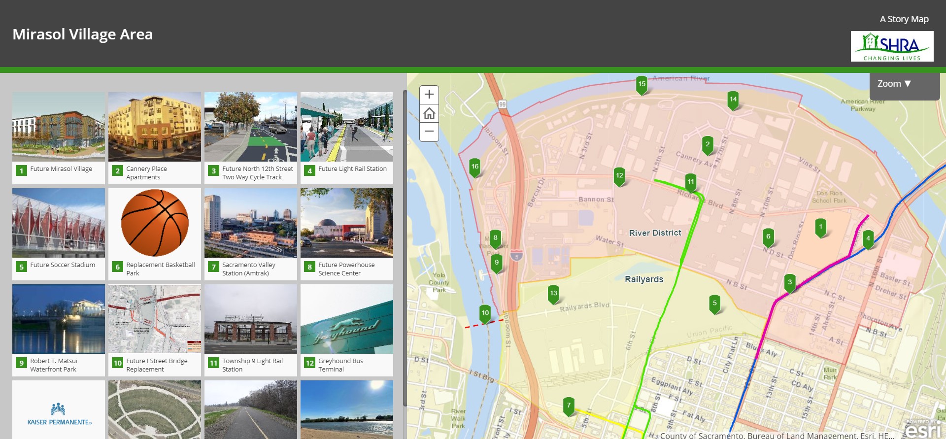
This project will show locations of many of the projects in the River
District in Sacramento. Highlighted will be Mirasol Village, a mixed income
housing development that is soon to be built in the River District. This
project intends to also show that developing the River District is beneficial
to low- and moderate-income people. Upcoming improvements in the River
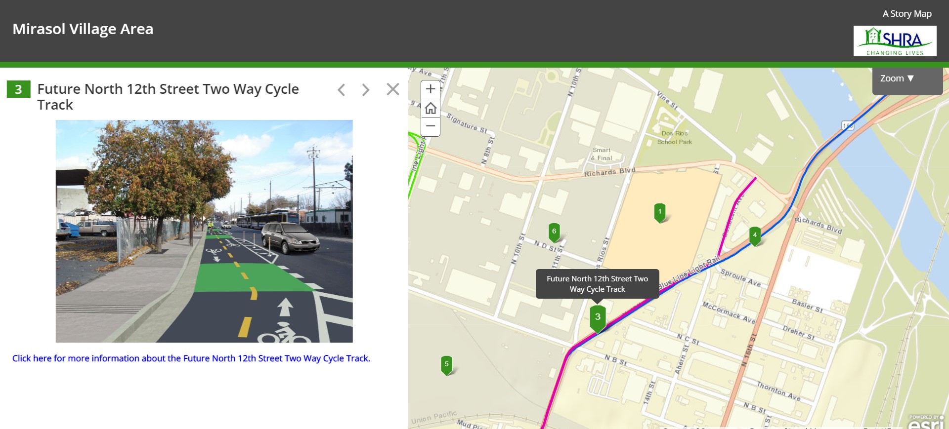
District include: a two-lane cycle track on North 12th Street, a new light
rail stop on North 12th Street, and a new basketball park. This project
intends to show locations in an ESRI story map using the story map short list
format with formatted pop ups and sidebar hyperlinks or descriptions.
|
|
Background
The Sacramento River District specific plan area is an area north of downtown
Sacramento bounded by the Sacramento River to the west, the American River to
the north and the Railyards specific plan area to the south. Many of the
buildings are industrial and the area has been somewhat cut off from the rest
of downtown. There have been some improvements to transportation in the River
District and there are more improvements planned. Sacramento City's River
District Specific Plan aims to adopt policies in order to achieve more
mixed-use transit-oriented area. The city hopes to incorporate housing units,
office space, retail, industrial, and hotel units.
|
|
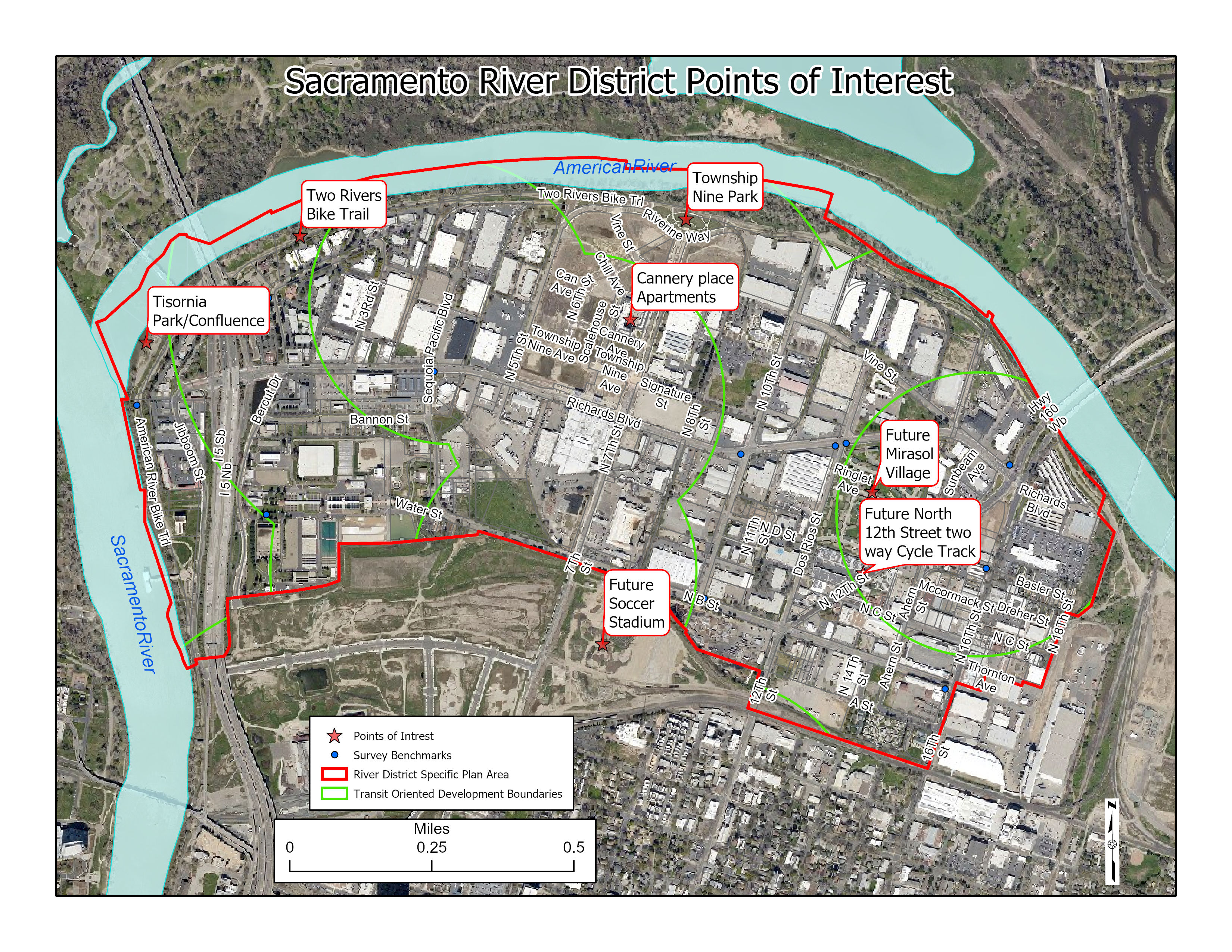
Several points of interest in and near the Sacramento River District
The River District Specific Plan area is outlined in red.
The green arcs show the Sacramento City Transit-Oriented Development
Ordinance. The Transit Oriented Development Ordinance helps incentivize
developers to build types of developments that would be supportive to users
near light rail stations. The boundaries are determined by what was within
one-quarter mile or one-half mile walking or biking distance from a light
rail station.
City
of Sacramento Transit-Oriented Development Ordinance
|
|
|
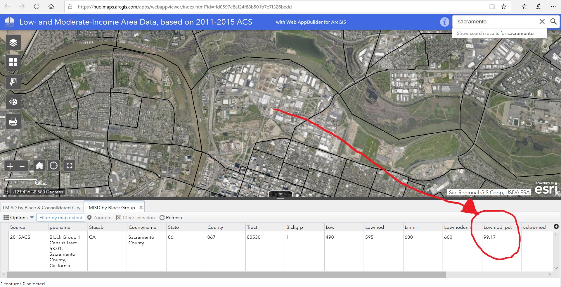
This map shows that almost everyone (99.17 % of people) that live in the
River District are classified as low- and moderate-income.
This income data is one factor used in determining whether Community
Development Block Grant (CDBG) funding can be used in an area. The data is
based on 2011-2015 ACS which is the most current at the time of publication
for this type of data.
Housing
and Urban Development (HUD) Low- and Moderate-Income Data
|
|
|
Methods
Data from multiple sources were used for this project. Sources included:
coworkers, Sacramento City and County open data portals, previous printed
maps from Sacramento City and Sacramento Housing and Redevelopment Agency
(SHRA), Housing and Urban Development (HUD), and many web searches.
|
|
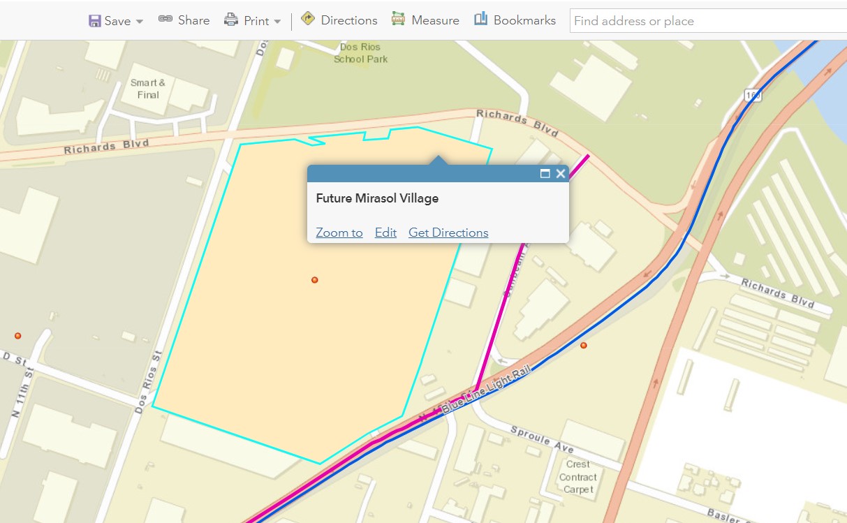
A story map short list format was selected by the client. Careful research
about how to produce a quality short list was performed also how to display
different elements such as the light rail lines and the polygon shape of
Mirasol Village correctly on the web map. The map on the right shows the
polygon parcel overlaid on the web map. This was done because the basemap was
still showing buildings that have since been demolished. It also shows the
blue light rail line and the purple future cycle track.
|
|
|
Results
An interactive story
map shortlist was selected by the client to show some of the developments in
and around the River District. It shows that with the transportation and
other improvements the River District would be a good place to live and spend
time in. Below shows how close the future Mirasol Village will be to
alternate forms of transportation.
|
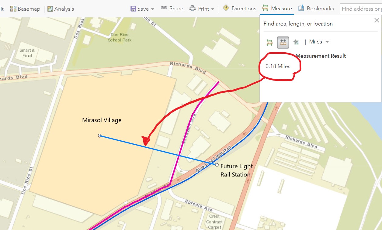
|
Transportation
Option
|
Miles from Mirasol
Village
|
|
Future
Light Rail station
|
0.18
|
|
Cycle
Track
|
0.12
|
|
Greyhound
|
0.78
|
|
|
|
Figures and Maps
|
|
|
|
Analysis
Currently the vast majority of people that live in the River District are low
and/or moderate income. For low- and moderate-income people transportation
costs can be overwhelming. The future Mirasol Village is very close to many
alternative forms of transportation. Mirasol Village will be a mixture of
public housing, affordable (tax credit) housing and market rate housing. By
viewing the story map one can also see that future developments would be
close to alternate forms of transportation. Sacramento City's Transit
Oriented Development (TOD) ordinance will allow for developers to be
incentivized to build for people to utilize the alternate forms of
transportation. Future plans include the I Street Bridge replacement going
through Richards Boulevard and more streets going through Railyards. With
more ways to get to the River District the hope is to spur development and to
get more people to live and work in the area. With more people living and
working in the area the safety of the River District could be increased.
|
|
Conclusions
With close alternate forms of transportation, lower-income people can afford
to eat better, have a better opportunity to get to work, and easily get
downtown. Future improvements in the River District will help lower-income
people.
|
|
References
Meer, Ben van der, 2019. Twin Rivers Redevelopment Releases New Housing
Plans.
https://www.bizjournals.com/sacramento/news/2019/11/01/twin-rivers-redevelopment-releases-new-housing.html;
Web2019.11.09
|
|
link
|| Story Map ||
|