Title
Pollution Burden on Disadvantage Communities in the San Joaquin County, California
Author Information
Yared Kebede
American River College, Geography 350: Data Acquisition in GIS; Fall 2019
W1628241@apps.losrios.edu
Abstract
The California Communities Environmental Health Screening Tool (CalEnviroScreen) environmental and population indicator dataset was used to assess the pollution burden on disadvantage communities in the San Joaquin.
Introduction
The California Office of Environmental Health Hazard Assessment (OEHHA) developed a tool (CalEnviroScreen) using 20 environmental and population indicators to identify the environmental health of California communities that are disproportionately burdened by pollution. The San Joaquin county is one of the most economically disadvantage counties in California.
Background
The California Environmental Protection Agency designates disadvantaged communities as the top 25% highest scoring areas using results of the CalEnviroScreen screening tool (Cal EPA, 2017). The individual score for pollution, poverty, and asthma incidence on children were compared in areas designated as disadvantage communities in the San Joaquin county.
Methods
The shapefiles used in this project were downloaded from the OEHHA website (CalEnviron Screen 3.0). The census tract layers were used to evaluate the pollution, economic, health, and environmental burdens by census tract (TIGER/Line Shapefiles). The clip tool was used to extract the CalEnviroScreen pollution, poverty, asthma and sensitive population (children) indicator shapefiles for the San Joaquin county. The selected indicators were mapped in Arc Map 10.7.
Results
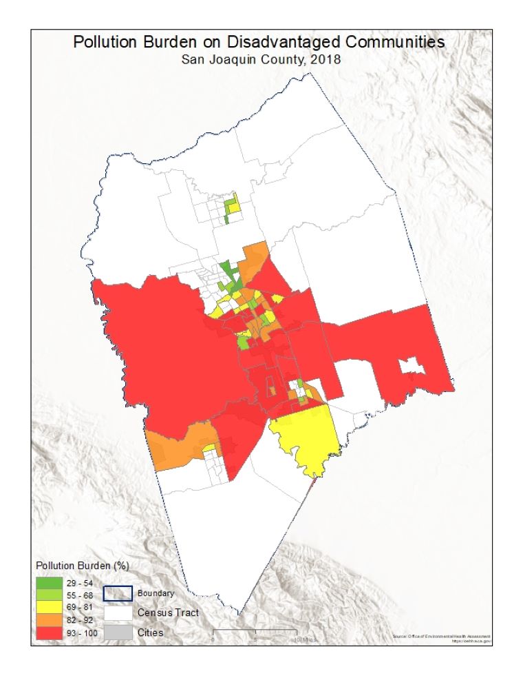
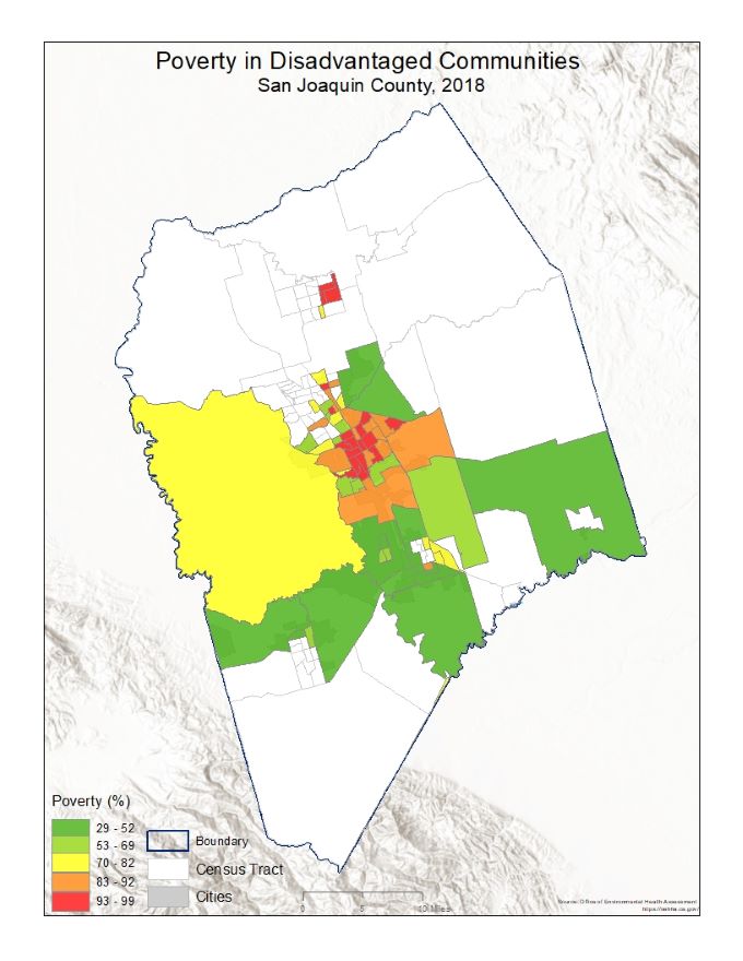
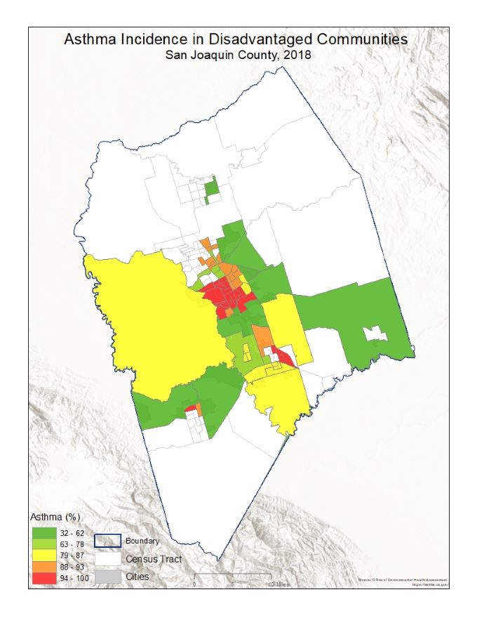
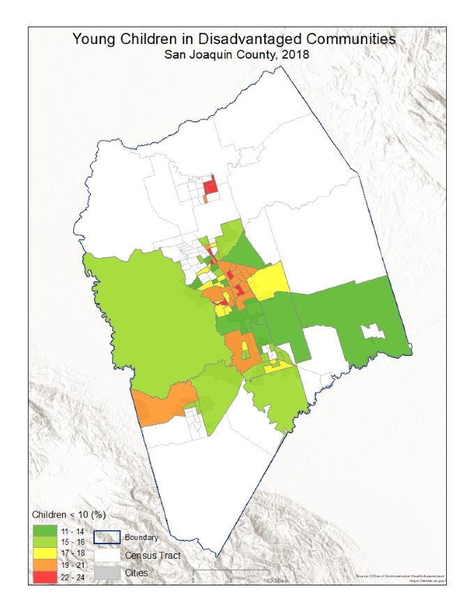
Although disadvantage communities are disproportionally affected by pollution burden throughout the San Joaquin county, the south Stockton neighborhood was identified for high poverty level, asthma incidence and the proportion of children under the age of 10, which are most likely to be impacted by the pollution burden.
Figures and maps
The following maps indicate the score for pollution burden, environmental effects, socioeconomic factors and population characteristics
Analysis
The comparison of the various indicators indicates a strong association between the incidence of asthma and poverty. The areas designated as disadvantage communities all have a high score since the areas are identified based on this score. However, children in the south Stockton neighborhood are most burdened by pollution and associated health and socioeconomic factors.
Conclusion
This project using the CalEnvironScreen tool dataset identified areas in San Joaquin county disproportionally impacted by poverty, pollution, and high incidence of asthma. Local and State government should develop a policy that prioritize disadvantage communities.
References
California Communities Environmental Health Screening Tool, Version 3 (CalEnviroScreen 3.0). Office of Environmental Health Hazard Assessment and the California Environmental Protection Agency, Sacramento, CA http://oehha.ca.gov/calenviroscreen/report/calenviroscreen-30. Accessed 16 December 2019.
California Environmental Protection Agency. Designation of Disadvantage Communities Pursuant to Senate Bill 535. https://calepa.ca.gov/wp-content/uploads/sites/6/2017/04/SB-535-Designation-Final.pdf. Accessed 15 December 2019.