| Title The Changing Landscape of Napa and Sonoma County | |
|
Author Kayla Rennison American River College, Geography 350: Data Acquisition in GIS; Fall 2020 | |
|
Abstract The focus of this project was to get visual understanding of what has been both lost last 3 years in the fires of both Napa and Sonoma County. | |
|
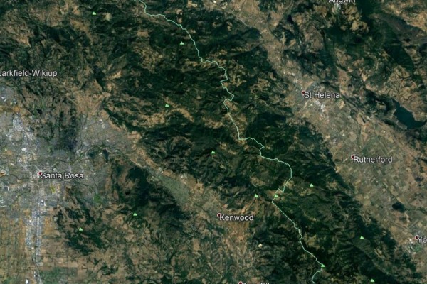
Introduction Napa and Sonoma counties are known for amazing parks, artists, wine and general historic atmosphere. From the fort General Vallejo left unfinished to the numerous family owned, multigenerational wineries that have become a destination goal and then further to the thriving art scenes near Sonoma State. | |
|
Background Over the last two decades the area has been getting hotter, dryer and turned quite literally into a tinder box but over the last 4 years thing have exploded. Maintenance on the aging powerlines, and on the eucalyptus trees that line highway 12 is nonexistent. Brush has gone untended and uncleared on property. Well meaning but extremely restrictive environmental and historical laws have all but strangled the ability to care for the flora here on residential properties. In fact, in the last 5 years a new season has cropped up due to these factors : Fire Season | |
 | |
|
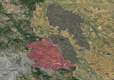
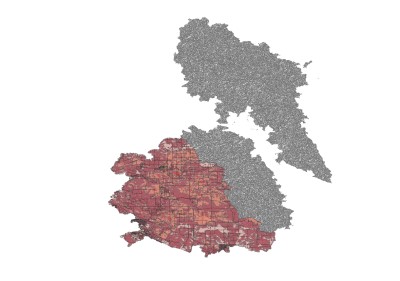
Methods Using a combination of burn scar records and images from the USGS I was able to pull together enough information to get a few visual references of before and after. Through the use of layering, colorizing, clipping and analyzing the layers in combination with actual foot work and some statistical data taken from Cal Fire I was able to get a true sense of the devastation. There have been many fires over the last 4 years, and I chose to use the Glass Fire for my images as it demonstrated the true destructive force of an unhindered burn. I actually spent most of my time on collecting accurate data on the fires themselves. I collected data specifically on the 6 largest fires by acreage, since 2017 withing Sonoma or Napa county. I did decide to add in County fire, even thoug that fire was between Napa and Yolo county, because it would be inaccurate otherwise. |
|
|
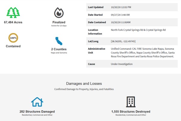
Results After After compiling data from the Atlas, Central LNU Complex (Tubs, Nuns/Adobe/Norrburn/Patrick/Oakmont)Fires from 2017, the County Fire from 2018, the Kincade Fire from 2019 and the Glass Fire from 2020, it has become clear how genuinely devastating these fires are becoming. In totality these fires have decimated 380,517 acers, damaged 1,614 structures, destroyed 9,069 structures, injured 5 people and killed 31. Out of the last 1,449 days (or since January 1st, 2017, if you prefer) we have spent 364 on fire. 1 day short of a full calendar year. Below I've added a screenshot from Cal Fire of just the stats on the Glass fire, for consistency. | |
 | |
|
Analysis Based on the information I collected I'd confidently say that Fire Season is here to stay. I would even hypothesize that between August 14th and November 14th of next year, there will be a fire in Napa or Sonoma County that burns at least 36,000 acers, will destroy between approximately 175 and 2,848 structures and kill at least 3 people. I just hope my hypothesis is completely wrong as this is a morbid reality I would like to avoid. | |
|
Conclusions This project may seem morbid initially because the fires do not look like they are going to stop anytime soon. However, Maintenance on the powerlines, proper clearing of brush, Flora care and management might be able to help. Not to sell myself short but if a second semester GIS student can find this information, that means it’s becoming more readily available. With more data, more studies and more evidence it will be easier to convince the powers that be to invest in what is necessary to prevent or at least prolong the destruction. | |
|
References 1. California Department of Forestry and Fire Protection (CAL FIRE). Glass Fire. Cal Fire Department of Forestry and Fire Protection, 2020, www.fire.ca.gov/incidents/2020/9/27/glass-fire/. 2. Wildfire Perimeters. California State Geoportal, gis.data.ca.gov/datasets/f72ebe741e3b4f0db376b4e765728339_0. 3. Sonoma and Napa Area. Google Earth, Google, 2018, earth.google.com/web/@38.45275958,-122.51213203,47254.85721741a,0d,35y,-1.6894h,0.0000t,0.0000r?utm_source=earth7. |