| Title Framework Theme Geodatabase Project – Desolation Wilderness | |
|
Author John Welsh American River College, Geography 350: Data Acquisition in GIS; Fall 2020 | |
|
Abstract This geodatabase includes information I can use to explore the Desolation Wilderness area including the boundary, trails, streams, water bodies, aerial imagery, elevation, and more. | |
|
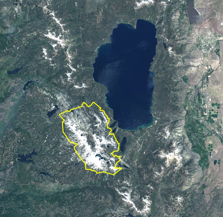
Introduction This project is a Framework Theme geodatabase of Desolation Wilderness. Located west of Lake Tahoe, Desolation Wilderness is approximately 64,000 acres of sub-alpine and alpine forest, granite peaks, valleys, and lakes. | |
I frequently backpack in Desolation Wilderness so I thought it would be interesting to create a geodatabase primarily for my own personal use. In this project, I use feature classes that I have created as well as data layers acquired from external sources for my geodatabase content. The Desolation Wilderness geodatabase includes information I can use to explore the Desolation landscape including the wilderness boundary, trails, streams, water bodies, aerial imagery, elevation, and more. |
|
|
Background My passion for backpacking and GIS inspired me to select Desolation Wilderness as my geographic area of interest. Not only do I enjoy Desolation for backpacking, but for trail running, and hiking as well. For this project, I was able to incorporate a trails feature class of Desolation Wilderness that I personally digitized. Additional geospatial data included in this project was acquired from GIS Clearinghouses and feature service websites. The additional feature classes included in the Framework geodatabase are layers that are relevant to the area of interest such as streams, water bodies, wilderness boundary, elevation, and satellite imagery. This data would be of interest to most backpackers who want to research a wilderness area prior to an excursion. In my case, I just find examining the geospatial data fascinating. Other feature classes added to the geodatabase fulfill the Framework Theme requirements of this project so that all seven themes are represented. | |
|
Methods All geospatial data downloaded for the Desolation geodatabase was immediately organized into their respective Framework Theme folders created in Windows Explorer. This made adding folder connections and feature classes to the map project easy and orderly. | |
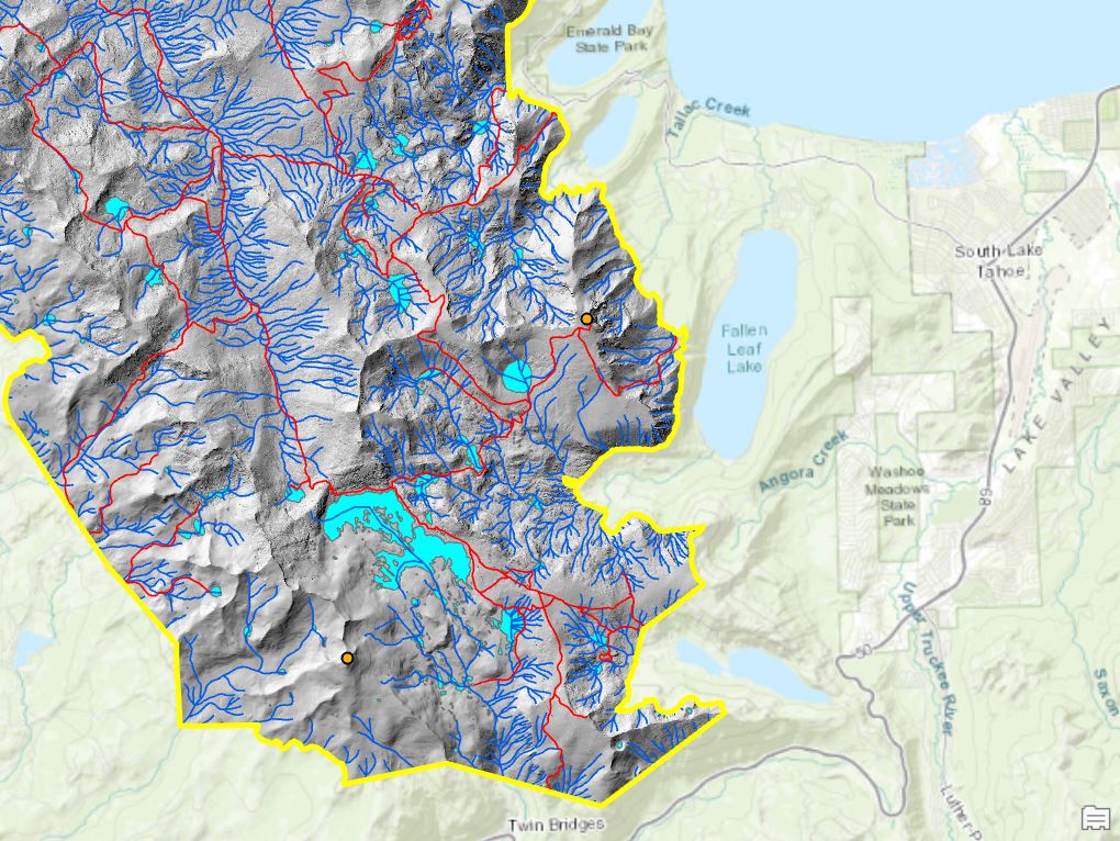
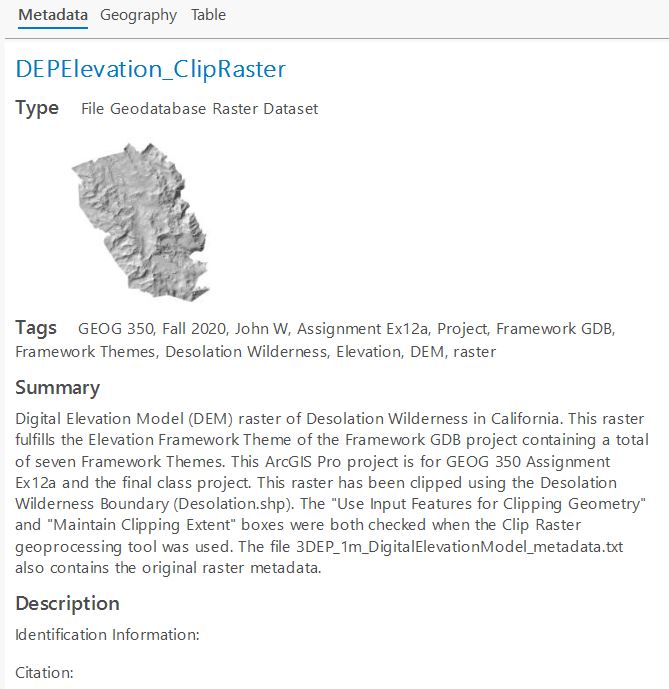
The Desolation geodatabase is comprised of the feature classes listed below, followed by a brief description, and the Framework Theme in brackets. 1. Desolation – boundary of Desolation Wilderness [Governmental Units] 2. Trails_Clip – trails [Transportation] 3. nhd24kst_l_mbr_Clip – streams [Hydrography] 4. nhd24kwb_a_mbr_Clip – water bodies [Hydrography] 5. DEPElevation_ClipRaster – Digital Elevation Model (DEM) [Elevation] 6. Base_Remote_SensingNAIP_2018_ClipRaster – aerial imagery [Digital Orthoimagery] 7. GCDW20_Clip – survey marks [Geodetic Control] 8. plsssection_a_mbr_Clip – Public Land Survey System (PLSS) [Cadastral] | |
Geoprocessing The feature class I digitized was imported to a new ArcGIS Pro map project from the original geodatabase in which it was created. Most of the layers in this project were geoprocessed using the Clip tool. To clip the aerial imagery and DEM raster feature classes, the Clip Raster tool was used. All feature classes were clipped using the Desolation boundary. |
|
|
Data Sources The Desolation Wilderness geodatabase contains feature classes from several sources. One of the layers was custom digitized. Other layers came from GIS clearinghouses and feature service websites. Custom Digitized The trails feature class was digitized in the year 2020 using the ESRI Basemap (USA Topo Maps). GIS Clearinghouses and Feature Service Websites The remaining feature classes of the geodatabase were acquired from the GIS clearinghouses or feature service websites below: Geospatial Data Gateway – the streams and water bodies feature classes were downloaded from the Geospatial Data Gateway. This geospatial data service is made available through a partnership between three U.S. Department of Agriculture (USDA) Service Center Agencies: Natural Resources Conservation Service, Farm Service Agency, and Rural Development. Wilderness Connect – the Desolation boundary was acquired from Wilderness Connect. Wilderness Connect maintains and updates wilderness boundary data annually using official national agency wilderness GIS sources. Data.gov – the DEM was sourced from Data.gov. | |
|
Results | |
| No challenges were encountered in the geoprocessing of data. Feature classes downloaded from the sources listed above included metadata files in .txt, .htm, or .xml format. The metadata from those files was copied and pasted into the final versions of the eight feature classes for this project. A metadata template was used for efficiency and a consistent format. Thumbnails were added to all feature classes in the Desolation geodatabase as well. Finally, a readme.txt stored in the Framework Theme folder provides descriptions of the eight feature classes, the Framework Theme category they belong to, and the name of the metadata file for each feature class. |
|
|
Future Enhancements The main future enhancement to the Desolation geodatabase will include adding a backpacking zone feature class. Backpacking in Desolation Wilderness requires booking a permit for a specific zone the backpacker is going to stay in for the first night only. Creating a zone feature class would involve using a Desolation Wilderness zone map image to georeference and digitize zone polygons in ArcGIS Pro. Another idea is to integrate Collector or Survey123 for adding backpacking camp sites as point features to the Desolation map. | |