SPATIAL RACIAL SEGREGATION AND DISPLACEMENT, DETROIT 1950 – NOW
Ricardo W. Cermeno Pena
American River College, GEOG 350: Data Acquisition in GIS; Fall 2022
Contact Information: W1548054@apps.losrios.edu
This project uses GIS data and other data to expose in maps, tables, aerial photography, and other pictures, how the Afro-American community in Detroit have been suffered and still suffers the harm of inequities through discriminatory laws and actions in all facets of life, from housing and health to education and employment. This study is based in historical data, but also uses current data to emphasize this still unresolved and shameful issue. Detroit, has historically a special racial signification and Martin Luther King gave a speech here 3 weeks before his assassination. Issues analyzed are: residential racial segregation by urban planning, inaccessibility to bank loans, mortgages and insurance, mass transit problem, home ownership inequity.
The racial inequity along with wars, and the global warming of the planet, is one of humanity's greatest challenges. The racial inequity principally is represented by the enormous and persistent wealth gap between races. Economic growth that doesn’t include the minorities can only cause problems. The goal is to increase awareness, and efforts toward racial justice.
Infrastructure transforms communities. During the New Deal the Federal Housing Authority and the Home Owners’ Loan Corporation “redlining” housing maps planted the seed of the future ghettos of the U.S. making impossible for the population of the black neighborhoods to secure federally backed mortgages, bank loans and insurance; developers only took these areas to develop infrastructure with the consequence of the disgraceful racial segregation and displacement. So the vast interstate highway system and other infrastructure developed those years and later were so obviously divisive, forcing black families to live in segregated neighborhoods were more likely to be polluted.
First it is taken the maps made by the Home Owners’ Loan Corporation between 1935 and 1940, using data and evaluations from real estate professionals. This maps grade the different neighborhoods in a city based in the racial and ethnic identity and class of its residents, reflecting their mortgage security. Second, is mapped the location of postwar programs for “urban renewal” of those years and extended into the 1950s and 1960s with the creation of the Interstate highway system. Third, is taken current photographs and data exposing the spatial racial segregation and inequity.
Tables, maps, aerial photographs are used to demostrate that there were spatial racial segregation and displacement, also to demostrate there currently is racial inequality in Detroit.
| Population | 1950 | 1960 | 1970 |
| Total | 1,849,568 | 1,670,144 | 1,511,482 |
| White | not available | 70.80% | 55.50% |
| Of color | not available | 29.90% | 44.50% |
Detroit Population in the years of Urban Renewal
It shows de displacement of population in those years
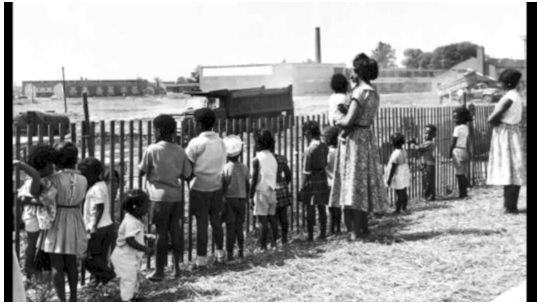
By the late 1960s, an estimated 8,231 families had been displaced by urban renewal projects in Detroit, 67% of which were families of color
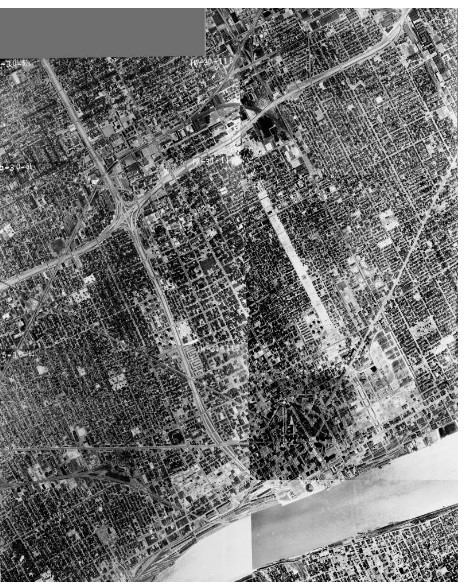
Above: Detroit 1961 Aerial images showing the construction of I-75 & I-375 intersection in the Black Bottom neighborhood, northeast of downtown.
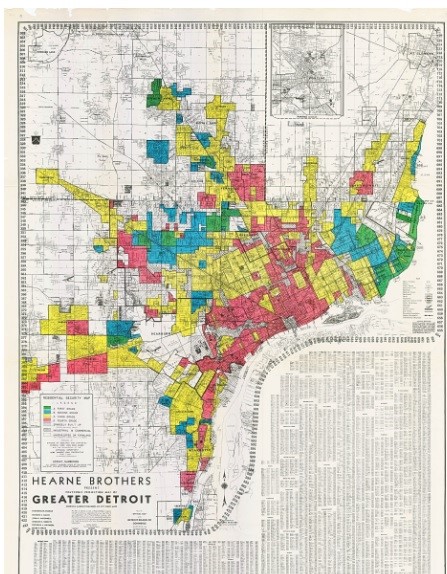
Left: Detroit HOLC redlining map 1939.
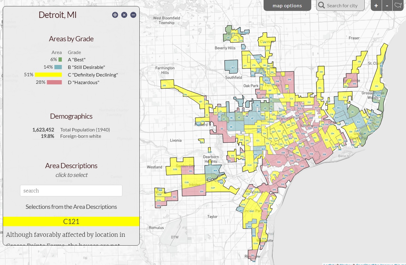
Neighborhoods graded by the HOLC in 1939. Red "Hazardous" areas are populated by African Americans principally.
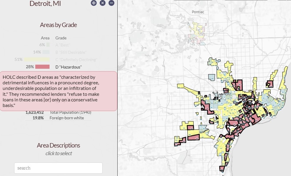
Detail of the description by the HOLC of the "hazardous" areas in the red backgroud. It clearly reads "...underdesirable population..."

Projects under the "Urban Renewal" program and racial composition between 1955-1966 mapped.
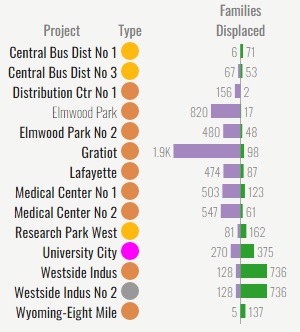
List of the projects and the number of displaced families by race (purple is black)
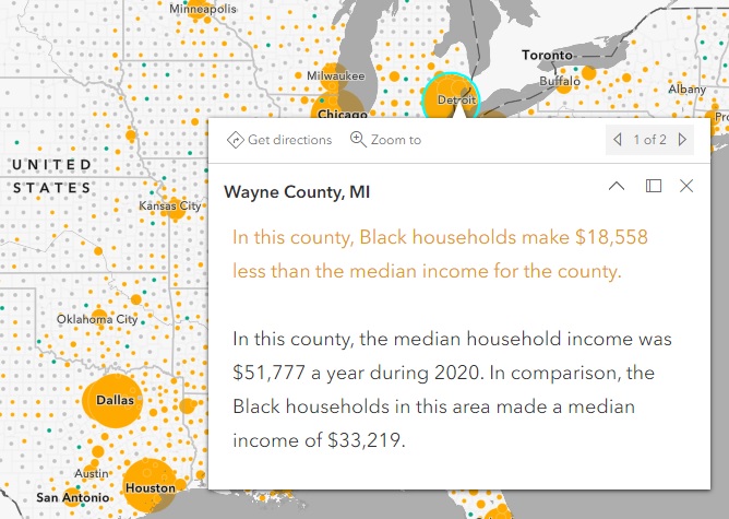
Indices of poverty, income, homeownership, also spatial segregation.
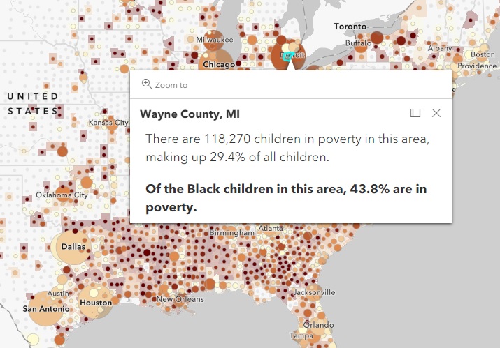
Poverty and income indicators mapped in Detroit.
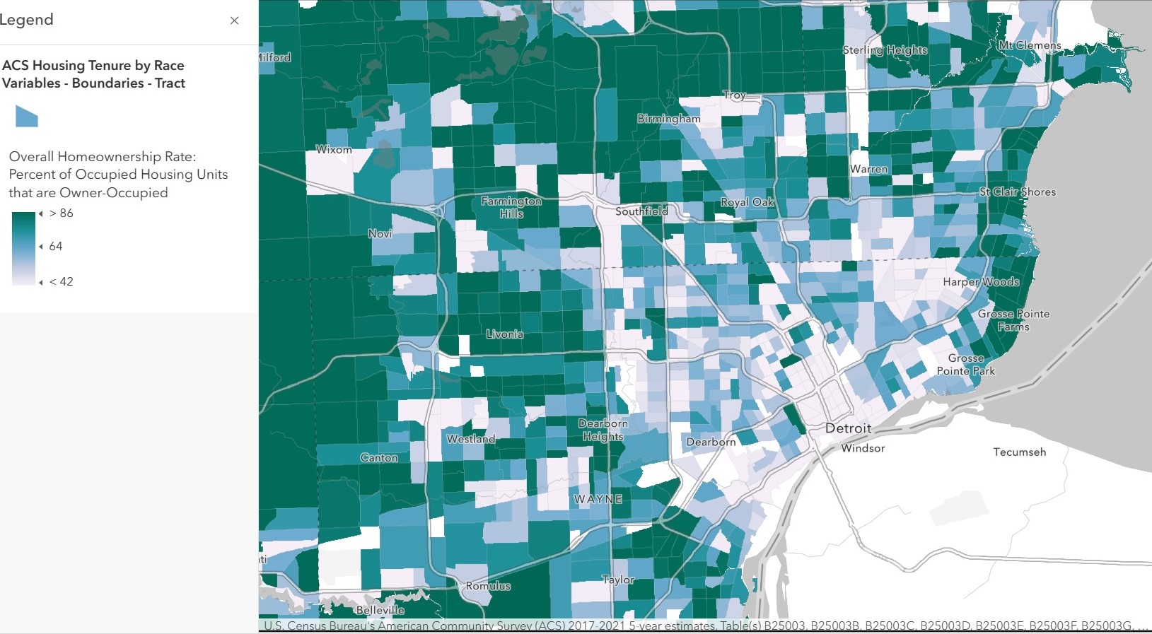
Homeownership and racial composition in Detroit.

Racial composition in Detroit 2010.
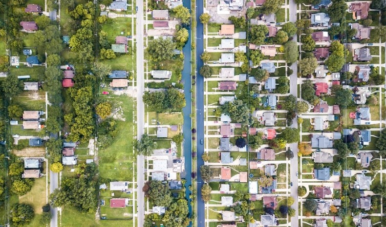
Spatial racial segregation, the Fox Canal separates Gross Point Park one of the wealthiest neighborhood from the Jefferson Chalmers an African American community in Detroit.
HOLC described D areas (populated mostly by African Americans) as “characterized by detrimental influences in a pronounced degree, under desirable population or an infiltration of it”. They recommended lenders “refuse to make loans in these areas (or) only on a conservative basis” The highway I-75 / I-375 interchange is placed where the African American Black Bottom neighborhood used to be, so a complete black neighborhood was destroyed. By the late 1960s, an estimated 8,231 families had been displaced by urban renewal projects in Detroit, 67% of which were families of color. There still are cases of spatial racial segregation in Detroit.
The HOLC maps and their documentation set the rules for a century of real estate practice. The postwar programs for urban renewal, destroyed black neighborhoods and displaced their residents with such regularity that African-Americans came to believe, in James Baldwin’s memorable phrase, that “urban renewal means Negro removal.” Though residents displaced were meant to get a compensation, it was too little or too late, or never coming. While Interstates were regularly used to destroy black neighborhoods, they were also used to keep black and white neighborhoods apart; as in words of Mayor Bill Hartsfield, as “the boundary between the white and Negro communities” for the I-20 in Atlanta. There still are cases of spatial racial segregation and inequity in different facets of life in Detroit. Being the home ownership a primary way that families build wealth, addressing this is a practical approach to start resolving the racial inequity.
Theme. The 1619 Project – The New York Times Magazine, August 18, 2019
HOLC maps. https://dsl.richmond.edu/panorama/redlining/#loc=10/42.348/-83.432&maps=0&city=detroit-mi
Detroit 1961 aerial images. Wayne State University
Drone maps. https://unequalscenes.com/
Land Use Plan, 1950. https://collections.lib.uwm.edu/digital/collection/agdm/id/3460/rec/15
Poverty and Income. https://storymaps.arcgis.com/stories/f62a10091cf84fb0bbde2868e8ec8c11
Homeownership map. https://racialequity.maps.arcgis.com
Population. U.S. Census Block Groups 2010
Links
urban renewal and displacement ||
current Detroit map || ||
raster map