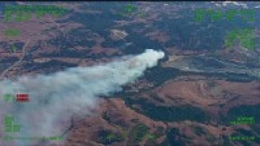
Figure 1. Anzar incident beginning in a large forest of Eucalyptus (KION 2022).
Detecting Eucalyptus Forests in the Central Monterey Bay using NAIP Imagery
Emily W.
American River College, Geography 350: Data Acquisition in GIS; Fall 2022
Eucalyptus is an invasive species that has a higher fuel load than native California species. Eucalyptus has influenced wildfire in California, leading to deaths, home loss, and lack of affordable homeowner’s insurance in some areas. Remote sensing has been successful in detecting and classifying categories of landcover, in this project it’s tested on detecting Eucalyptus in the central Monterey Bay. Supervised Classification analyzed over 100,000 acres on central Monterey Bay, 4,124.5 of which are Eucalyptus.
Eucalyptus was introduced to California and first planted in the mid-1800s. Blue Gum Eucalyptus was heavily promoted by the government by the 1900s which led to many monocrop Eucalyptus forests being planted and later mismanaged (Fire Safe Marin, 2021). This species grows in dense forests along the central coast and can develop into hazardous potential fuel for wildfire. In 1991 the Oakland “Tunnel” Fire burned 3,000 acres and killed 25 people. This wildfire’s quick spread and intensity has been attributed to dense eucalyptus stands in the area. In 2004 the Tam fire spread rapidly in a eucalyptus grove in Tamalpais Valley, and since residents have been unable to secure affordable homeowner’s insurance (NPS 2006). Most recently in July of 2022, the Anzar incident began in a eucalyptus grove (fig. 1) and spread to over 100 acres in the matter of an hour destroying one home and multiple structures (KION 2022). This project will focus on how to detect Eucalyptus forests in central Monterey Bay using remote sensing.
Figure 1. Anzar incident beginning in a large forest of Eucalyptus (KION 2022).
Remote sensing has been used in prior forest analysis research. In 2020, Yan Gao et al focused on forest degradation and deforestation in their analysis using remote sensing. Their same remote sensing principles using monitoring and measurements can be applied to forest neglect such as failing to manage non-native invasive species like Eucalyptus. Yan discusses the challenges associated with using remote sensing in that detecting understory species is quite difficult (2021). One issue with Eucalyptus is that it was planted as a monocrop and maintains that form, reducing biodiversity in areas, and contributing to potential fire hazards (Wolf et al 2016). In Leite et al 2020 study, they used lidar based technologies combined with physically measuring trees to detect and monitor eucalyptus growth but found it very expensive and time consuming. Based on these different studies, there are many ways to detect and monitor invasive eucalyptus growth and remote sensing may be the most cost-effective tool. In “Using Remote Sensing to Predict Invasive Plant Species Distributions in Wetlands,” Bernard sought to identify large areas of invasive species such as Arundo and Eucalyptus in San Diego, County. To do this, their approach was to use remote sensing techniques and run statistical analysis on the data to determine which remote sensing technique was the most successful. Three types of imagery were used for this analysis. First was imagery from National Agricultural Imagery Program (NAIP), the second was high resolution color infrared aerial imagery (CIR), the third was Landsat hyperspectral imagery. For each invasive plant, three well-known multivariate statistical analyses, Discriminant Function Analysis (D.F.A.), Quadratic Discriminant Function Analysis (Q.D.F.A.), and CART, were used to identify the models that best separated invasive plants from surrounding vegetation. They found that the best model for detecting Eucalyptus was to use a Q.D.F.A. with a combination of NAIP imagery and Landsat imagery. They determined that CIR imagery was not useful for separating invasive plants from non-invasive plants using any of the three multivariate analyses (Bernard 2010).
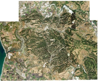
For this project, imagery data was retrieved using Earth Networks and analyzed in ESRI’s ArcPro ver. 2.9. To begin, an area of interest (AOI) was defined along central Monterey Bay (Fig. 1). This was then used to retrieve NAIP 2020 imagery and imported to ArcPro. Once the data was imported, the tool “mosaic raster” was used to create one large, consolidated imagery dataset (fig. 2). Once the data was consolidated, the next step was Supervised Classification using NLCD 2011 schema (National Land Cover Database) with Eucalyptus as an additional class. Each class was sampled 30 times prior to running the raster tool.
Figure 2. NAIP Imagery of the Central Monterey Bay mosaiced.
Supervised Classification analyzed over 100,000 acres on central Monterey Bay (fig. 3). The categories with the highest acreage were Herbaceous, Barren, and Shrubland while the categories with the lowest acreage were Water, Eucalyptus (fig. 4), and Wetlands. Eucalyptus ranked second to lowest in overall acreage with 4,124.5 total acres (Table 1).
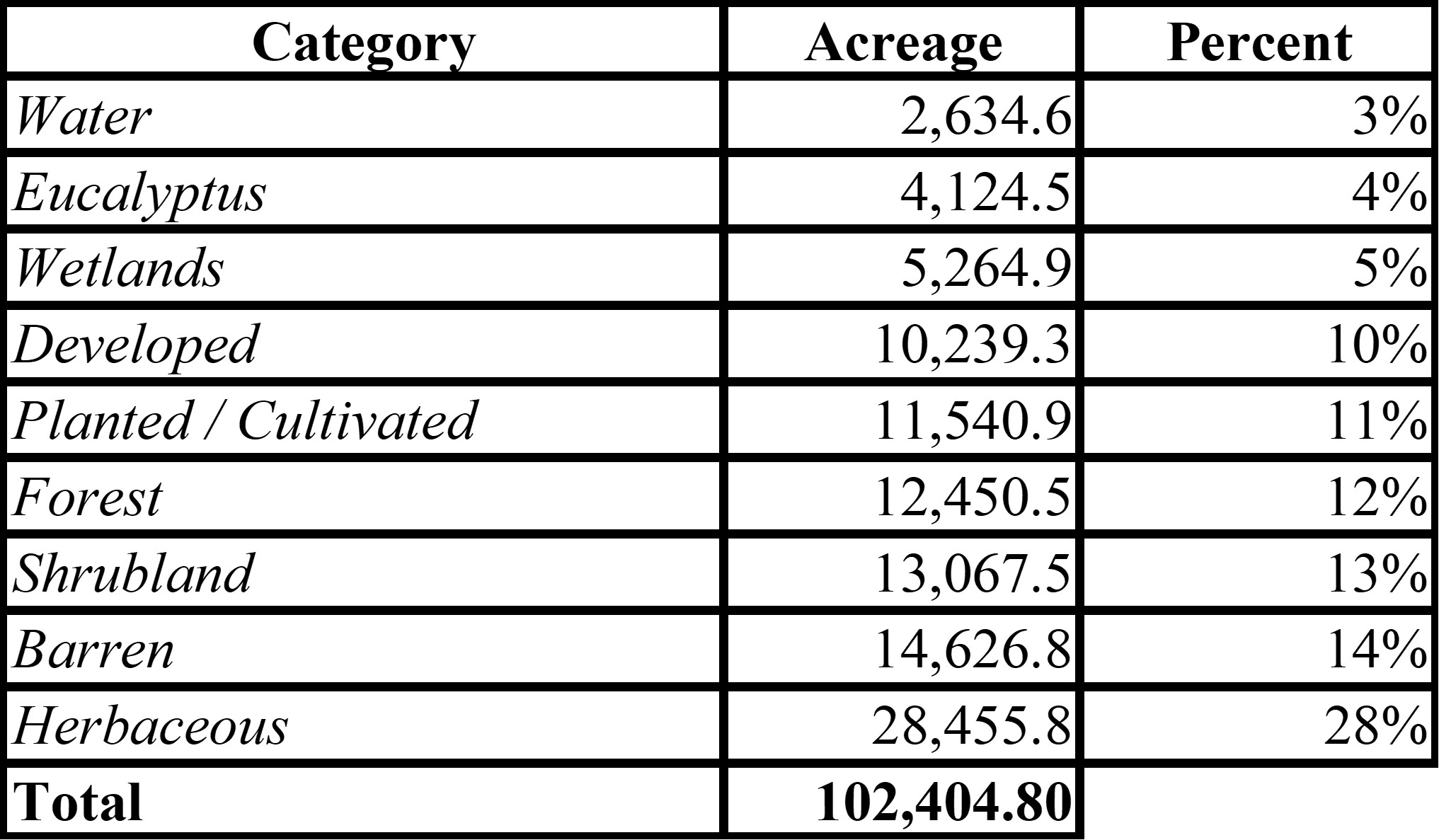
Table 1. Total acreage results of NAIP imagery classified.
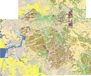
Figure 3. Results of Central Monterey Bay NAIP imagery classified into categories.
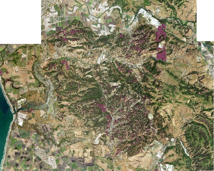
Figure 4. Results of Central Monterey Bay NAIP imagery classified as Eucalyptus (purple) over NAIP Imagery.
While Eucalyptus didn’t rank high as an overall category, it does account for 4 percent of landcover on the central Monterey Bay. The remote sensing steps were successful in detecting large known areas that are dense and overgrown. These areas were cross referenced using imagery and google street view.
This tool can be used by land managers, government, and/or the private sector to identify areas of invasive species such as Eucalyptus in large AOI for projects that may be focused on restoration or fuel reduction. Future analysis may include comparing population density in comparison to proximity of hazardous fuels or identifying parcels that allow for overgrowth of invasive species and working with the landowner to reduce the fuels. Eucalyptus can be positively identified using remote sensing techniques and classified for future land use planning.
Bernard, C.L. April 30, 2010. “Using Remote Sensing to Predict Invasive Plant Species Distributions in Wetlands” Thesis Dissertation URL: https://scholarworks.calstate.edu/downloads/w6634393n Accessed: 11/5/22
Fire Safe Marin, 2021. Eucalyptus. https://firesafemarin.org/plant/eucalyptus/#:~:text=In%20the%201850s%2C%20Eucalyptus%20trees,encouragement%20of%20the%20state%20government.
KION 2022 “Anzar fire near Aromas 100% contained” https://kion546.com/news/2022/07/21/anzar-fire-near-aromas-100-contained/
Leite, Rodrigo, et al. “Individual Tree Attribute Estimation and Uniformity Assessment in Fast-Growing Eucalyptus Spp. Forest Plantations Using Lidar and Linear Mixed-Effects Models.” Remote Sensing, vol. 12, no. 21, Nov. 2020, p. 3599. Crossref, https://doi.org/10.3390/rs12213599.
NPS National Parks Service. 2006. “A Complex Challenge FIRE MANAGEMENT, RESOURCE PROTECTION, AND THE LEGACY OF TASMANIAN BLUE GUM” https://www.nps.gov/pore/learn/management/upload/firemanagement_fireeducation_newsletter_eucalyptus.pdf
Wolf, K. M, & DiTomaso, J. (2016). Management of blue gum eucalyptus in California requires region-specific consideration. California Agriculture, 70(1). http://dx.doi.org/10.3733/ca.v070n01p39 Retrieved from https://escholarship.org/uc/item/9db933pg
Yan Gao, Margaret Skutsch, Jaime Paneque-Gálvez and Adrian Ghilardi “Remote sensing of forest degradation: a review” Environmental Research Letters, Volume 15, Number 10. Environ. Res. Lett. 15 103001
Links
non-tables page ||
index page || ||
original