“Look for Parking!”
An Assessment of Mobility Throughout the Sacramento Grid at Night
Larysa Fomina
GEOG 350 Data Acquisition
Final Project
ABSTRACT
The goal of this project was to find the best mode of transportation throughout the Sacramento Grid after sunset. The four modes of transportation considered were driving, public transit, biking and walking. Analysis was based on availability street lighting, parking, and of respective routes and lanes throughout the grid area. Data suggests that biking may be the best mode of transportation for traveling throughout the grid.
INTRODUCTION
Having recently moved to Midtown Sacramento I wanted to know the best mode of transportation throughout the city grid so that I feel comfortable getting around. The modes of transportation I looked at were driving, public transit, biking, and walking. As it is currently fall and the sun goes down earlier in the day, street lighting was a major factor in my assessments as it is important for safety for all modes of transportation, especially walkability.
METHODS
To assess the effectiveness of each mode of transportation throughout the grid I overlayed layers that represented a concern associated with each method of travel. I then found areas that were either optimal for a particular mode of transportation, such as long-term parking, or were underserved in some way, such as a block that was missing street lighting.
In terms of walking, my main concern was street lighting because I would mostly be walking after sunset as it is typically already dark by the time I get off work. To represent walkability, I used a layer for street lighting from the City of Sacramento. Additionally, because all the other modes of transportation either include some walking or would benefit from increased visibility I also included lighting as a factor in all my other analyses.
For driving my main concern was being able to find parking with a reasonable time limit. To assess this, I found layers for on-street and off-street parking from the City of Sacramento. For street parking I queried the layer to only include spots at or above the 2-hour limit. I also symbolized the layer by the time limit to see where areas with more long-term parking was located.
For public transportation, I looked at the available routes throughout the grid. For public transit I used a layer on all routes within the Sacramento County, provided by CalTrans. I filtered the layer to only include the main, non-express, bus and light rail routes within the grid. Lighting was also a consideration for this method of travel because I would likely have to walk to and from bus stops to get to a destination.
Finally, biking was assessed by using a layer of existing bike lanes provided by the City of Sacramento. Again, lighting was an additional factor I considered for this analysis because I feel safer biking with additional lighting other than just my bike light.
I also want to mention some important parameters that were not considered due to lack or excess of data. For parking I did not include parking rates or end of time limits because, though these parameters would have been helpful to me in my analysis, that would have been too much to consider for the scope of this project. Additionally, for transit routes, there was no data included for bus or light rail stops in the layer that I downloaded from CalTrans. I also did not find any reliable data for transit stops on the Sacramento city, county or state geoportals. For biking, though there was data on routes, there was no reliable data included on bike parking which is an important factor in business or commercial districts.
RESULTS & ANALYSIS
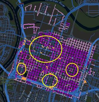
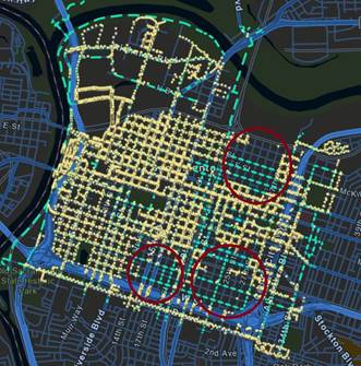
Walkability – represented by street lighting
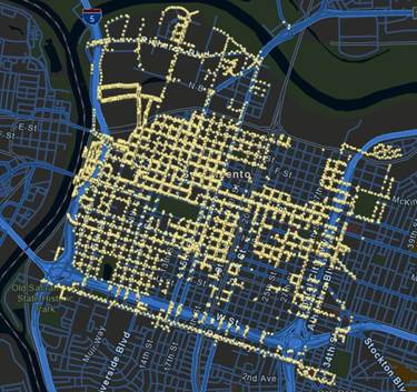
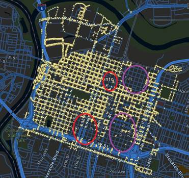
As seen on the left, parts of the Sacramento grid are relatively well lit while most of the eastern side is missing street lighting. Looking at the grid in context on the right, it is primarily more residential areas which are missing street lighting, in purple, which is understandable because too much light pollution is not desirable near their homes. However, the areas circled in red are closer to the commercial areas and could benefit from more street lighting. I would need further research on the zoning of these areas but if I were to walk alone after dark I may choose to go around these spots.
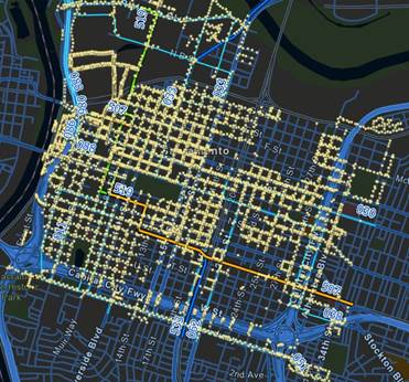
Driving – represented by parking
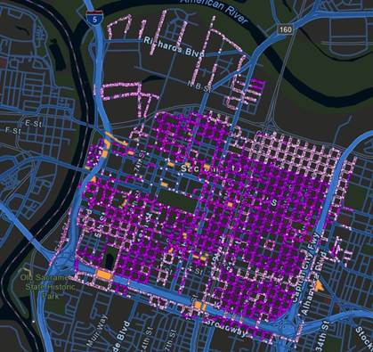
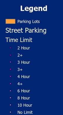
In my analysis I found that there is a decent amount of street parking throughout the Sacramento grid.
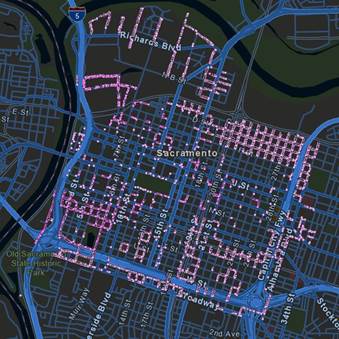
There is also a decent number of small parking lots near most of the areas where street parking is limited (left), however I would consider price rates for these parking lots before parking there.
On the right I queried for street parking spots with over a 6 hour parking limit. Most of these spots are near the edges of the grid. These would be the preferred parking spots for me because I would not need to worry about moving my car or paying extra. However, I would also need to make sure that I do not need a permit to park in those areas as they may be reserved for residents.
Lastly for parking I considered lighting. On the right I selected parking spots which were outside of a 50-meter radius of a streetlight. If I were to park in one of these areas I would want to make sure that I would not have to walk far to my final destination in the dark.
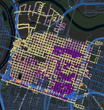
Public Transit
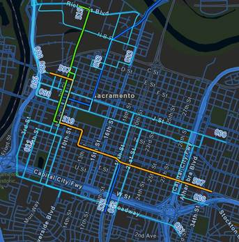
On the left are main, non-express, bus and light rail routes within the grid. Though there are a decent amount of public transit routes that run within the Sacramento grid, it look like the north and parts of the south end lack routes and also lighting. It seems that it may be harder travel to or from those areas using public transit. Also, bus schedules and stops would be important additional factors to consider.
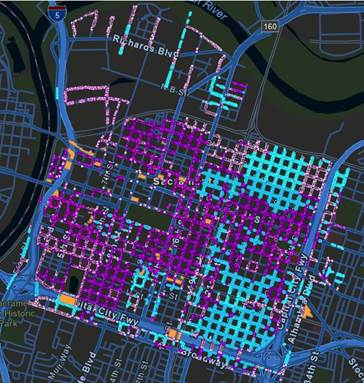
Biking
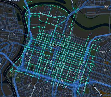
Bike lanes seem to be very well dispersed throughout the grid. There do seem to be smaller areas which lack bike lanes, but this may not necessarily mean that it is impossible to bike through those areas. There is also the possibility to get off and walk your bike to take a shortcut. On the right, there are areas which lack lighting which means it would be especially important to have a bike light in these areas.
CONCLUSION
Based on my findings it seems that biking is a great way to get around the Sacramento grid. There are many lanes dispersed throughout the grid compared to transit routes which are more limited and run on a schedule. I might also feel safer biking rather than walking because I can attach lights to my bicycle and get faster to my destination. Additionally, bike parking is not limited by time and does not cost anything. Though more data on bicycle parking would be helpful, considering all other safety concerns regarding biking such as a helmet and proper lights, I would likely consider biking on my next outing in the Sacramento grid.
SOURCES
Off Street Parking. City of Sacramento. https://data.cityofsacramento.org/datasets/1a75cd6cbadc4059990cd40620d81c56_0/explore?location=38.577564%2C-121.494305%2C14.69
ONSTREETPARKING. City of Sacramento. https://data.cityofsacramento.org/datasets/0060469c57864becb76a036d23236143_0/explore?location=38.562039%2C-121.455185%2C12.57
Existing_Bicycle_Facility. City of Sacramento. https://data.cityofsacramento.org/datasets/15f8e048d9ad4442a3e12b6182bcd4f2/explore?layer=1&location=38.569942%2C-121.432000%2C11.64
CA Transit Routes. CalTrans. https://gis.data.ca.gov/datasets/dd7cb74665a14859a59b8c31d3bc5a3e_0/about
Street Lights. City of Sacramento. https://data.cityofsacramento.org/datasets/3dca1faa7e0a40f79f31f95c0b2ebd17_0/about