Del Rio Trail Data Extract
Rafael Garcia (W1164129)
American River College, Geography 350 – Data Acquisition in GIS; Fall 2023
Contact Information: Rafael_Garcia916@comcast.net
As somebody who loves to bike ride and has lived next to the abandoned railroad corridor, I couldn’t be happier to hear about the Del Rio Project. I unfortunately struggled finding any ARCGIS online data on Del Rio Trail, or even recent articles or any decent maps on the Del Rio project, but I figured that left me with an opportunity. I could go for a bike ride and acquire the data myself on the Del Rio Trail and see it come to life
This city project is about the Del Rio Trail coming in Sacramento. The city of Sacramento has almost 5 miles of an abandoned railway corridor in the South Sacramento area. The trail will start near Pocket Road and end near at the levy near Land Park. The trail is not complete yet with a lot of the trail still undergoing construction. The goal by Caltrans, city officials and neighbors are to make the trail accessible and safer way of travel for residents of Sacramento. The city expects it to be a busy trail once it is fully open. The project is slated to end in 2024. There are currently no layers that cover this finished trail. My goal is to change that and make one.
I first created a web map through ARCGIS online, customized it so I can use ESRIs field maps application on my phone, went out collected data on the Del Rio trail.
Thanks to the ESRI community, there are countless amounts of different available pre-made layers. I was able to find layers that helped me assist in my project creation or provide further additional context if needed. There are existing layers of current trails but I could not find one specific to the upcoming Del Rio Trail.
I used my Apple iPhone 12 Pro while using my ESRI Field maps application to acquire data. After I initially collected my data the first time, I felt like it wasn’t enough. I needed more run throughs for further accuracy, and adding entry points could be useful for knowing where one could easily join the trail based on their own location. I also took pictures of many of the entry points and throughout the trail in general.
I ended up with 25-point entries on to the trail that I collected on my iPhone 12 Pro. The points were all slightly off where I collected the data, but the results were acceptable. As for the lines, I ended up with a large amount of line data (018) because my lines kept breaking (phone erroring out) even though I only rode the trail about 3 or 4 times. My data had no polygons. I went through and added comments and images to my data.
| Data Collected | Points | Lines | Polygons |
|---|---|---|---|
| Unique IDs | 27 | 18 | 0 |
| Photos | 31 | 21 | 0 |
| Comments | 27 | 17 | 0 |
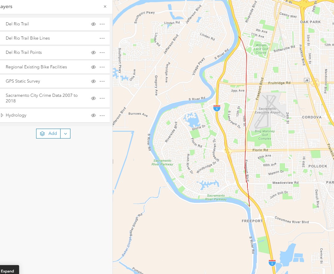
This is a map showing my original bike line data logging on the trail.:
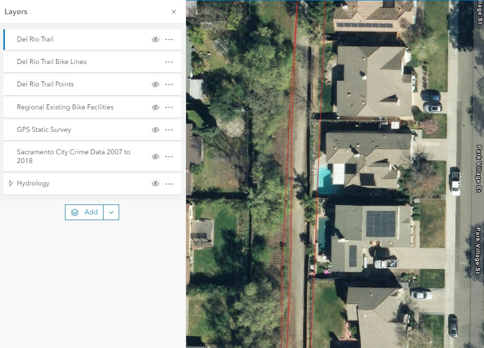
This is a zoomed in map of my line data logging on the trail, showing the errors that occur. You can see the lines going through peoples backyards:
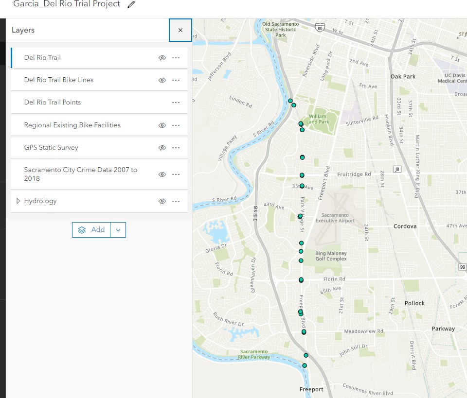
This is a map showing my entry points to the Del Rio Trail (After being manually adjusted if needed):
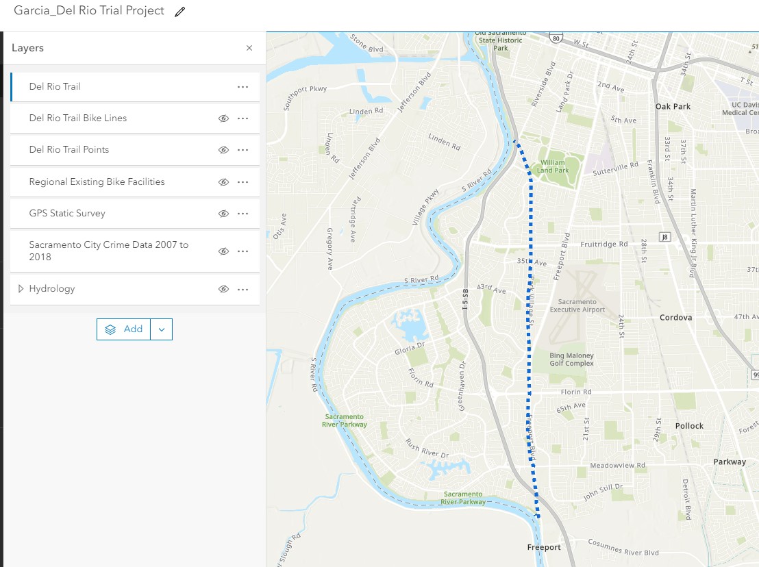
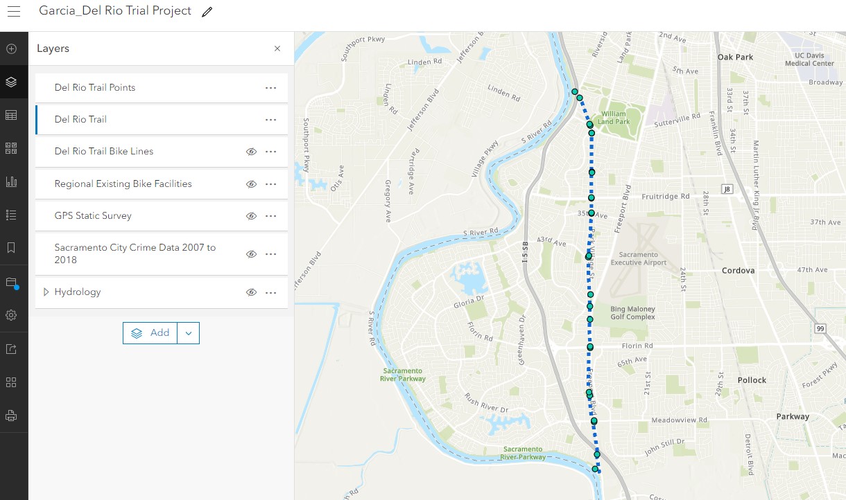
This map showing my final digitized trail map:
This map showing my final digitized trail map with the entry points included as well:
The overall project was a success. Cell phone GPS data logging was acceptable but not perfect. I rode the bike trail a few times and each of them had slightly different results. The discrepancies could also be the exact place I rode as well (on the left/middle/right of trail). I did notice some places that were definitely off the trail not where I was collecting data (such as in people’s backyards). The good news is that they, overall, still were accurate enough to give me a good sense of where the actual trail line is, to digitize my own final trail I ended up digitizing (also using my points/imagery as references as needed) a best fit through all the lines so they still ended up being very useful to get a true sense of accuracy. The entry points took some time because I had to stop often but ended up yielding similar results of the points being slightly off, causing me to manually adjust them when I got back to my workstation. Left image below shows Trail Entry Points, Right image shows original bike lines (zoomed in to show errors) to final digitized Del Rio Trail line.
This trail is great and very useful to me, because I can use it to get to work and even several of my family and friends’ homes. Before citizens, like me, were forced to go down the dangerous Freeport Road or go through several residents’ neighborhood streets which extends the ride massively. As far as GIS goes, this gave me the opportunity to go out and record some of my own data and see it come to life in my hands. I was very happy I was able to get the entire Del Rio Trail myself. A large part of the trail is still in construction, so I am also satisfied with how my data lines up with the existing bike trail routes (specifically how it connects with the levy trails). I thought that the trail would have been more often on the railroad, when in fact, it mostly ran near along it. In this experiment I have ran across a few negatives. The accuracy I got left a little to be desired. Better equipment (besides my phone) would have yielded better results. Because this trail is so new, I could not depend entirely on imagery base maps for accuracy. Also, sometimes when acquiring my data, my phone would error out often making for me to get the trail to be one long continuous line (I ended up doing it successfully on one attempt). The other negative I could see in the trail, is that it exposes many people’s backyards to those on the trail. I am sure most of those residents aren’t entirely happy with that. However, they do now get a nice useful trail right in their backyard. To those who could be interested, I even included ARCGIS Online data for Existing Regional Bike Facilities (to see how they connect to trail), Sacramento crime data from 2007 to 2018 (to see past crime occurrences in the areas) and nearby hydrology.
City of Sacramento 2022, Accessed December 10, 2023. https://www.cityofsacramento.org/DelRioTrail
GPS Static Survey, Publisher_SacCity, Accessed 8 December 2023, https://arc-gis.maps.arcgis.com/home/item.html?id=5a5fb0a127ff44ad98f8a48640e9529c&sublayer=0
Jordan Tolbert 2022, ABC10 Local News Website, ABC 10, Accessed 26 September 26 2023, https://www.abc10.com/article/news/local/del-rio-trail-sacramento-improvements/103-552cd771-4b1c-41c0-8c88-d29c15e3dce1
Regional Existing Bike Facilities, SACOG_Admin, Accessed 8 December 2023, https://arc-gis.maps.arcgis.com/home/item.html?id=028fc7fc8be548d9af219d95fc93b0f6&sublayer=0
Sacramento City of Arts and Culture, Del Rio Trail Art Website, Accessed 26 September 26 2023, https://www.delriotrailart.org
Sacramento City Crime Data 2007 to 2018, jlevien1_GISandData, Accessed 8 December 2023, https://arc-gis.maps.arcgis.com/home/item.html?id=ef313839802a498aa2305327d3bf9b2e&sublayer=0
USGS National Hydrography NHD Dataset Basemap Small Scale, SNC Admin (Sierra Nevada Watershed Improvement Program), Accessed 8 December 2023, https://arc-gis.maps.arcgis.com/home/item.html?id=75fae852621846ff904b316ce2e4d518
http://www.cityofsacramento.org/-/media/corporate/files/public-works/transportation/bicycle-master-plan/sacramento-2016-bicycle-master-plan.pdf
https://www.cityofsacramento.org/DelRioTrail