Mosquito Fire Burn Analysis
Danielle Kirkland-Shatraw, American River College, GEOG 350, Fall 2023
Abstract
Wildfires pose significant challenges to ecosystems and communities, particularly in Northern California, where the threat is recurrent and impactful. In response to the Mosquito Fire of September 2022 in Placer and El Dorado Counties, this research project employed a multi-faceted approach to assess the burn scar and investigate post-fire plant ecology. Utilizing Landsat 8 imagery and geospatial analysis tools in ArcGIS Pro, burn scar visualization and normalized burn ratio calculations were conducted, resulting in an accurate delineation of the burn area. Concurrently, fieldwork involved plant identification and quadrat sampling within a rural, moderately burned study area. A total of 23 plant genera were identified, and their occurrences were recorded in 10x10 feet quadrats, shedding light on the post-burn plant community dynamics. This research contributes to a comprehensive understanding of wildfire impacts, emphasizing the importance of integrating geospatial analysis with field-based ecological assessments.
Introduction
Wildfires are an inherent part of the ecological landscape in Northern California, shaping the region's plant communities and presenting profound challenges to both natural ecosystems and human settlements. The increasing frequency and severity of wildfires underscore the urgent need for comprehensive research to understand their impacts on plant ecology and the broader environment. Among the recent wildfires that have had lasting impact on the landscape is the Mosquito Fire, whcih burned from September 6th to October 22nd, 2022. Suspected to have originated from a faulty PG&E transmission line just above Oxbow Reservoir, burned in El Dorado and Placer Counties. Notorious for its history of negligence and inadequate maintenance practices, PG&E now faces legal action from both counties .The Mosquito Fire burned for a month and a half, exacerbated by the record-breaking heatwave that swept across Northern California in the days leading up to the incident. This wildfire destroyed 78 structures, leaving a significant scar on the landscape and prompting concerns about the long-term ecological consequences. In response to the Mosquito Fire, this research project seeks to delve into the intricate relationship between wildfires and plant ecology in the post-burn landscape.
Methods
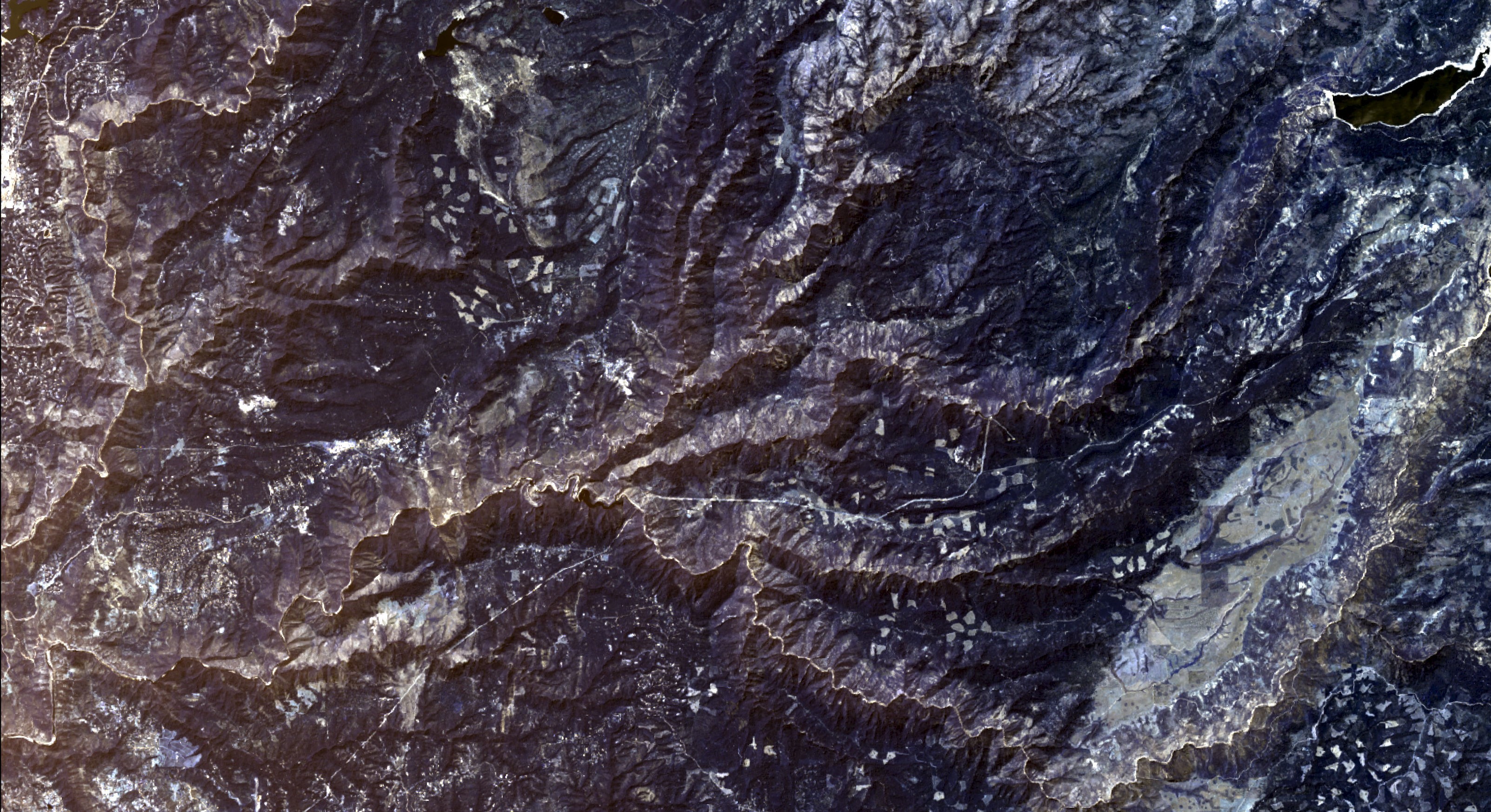
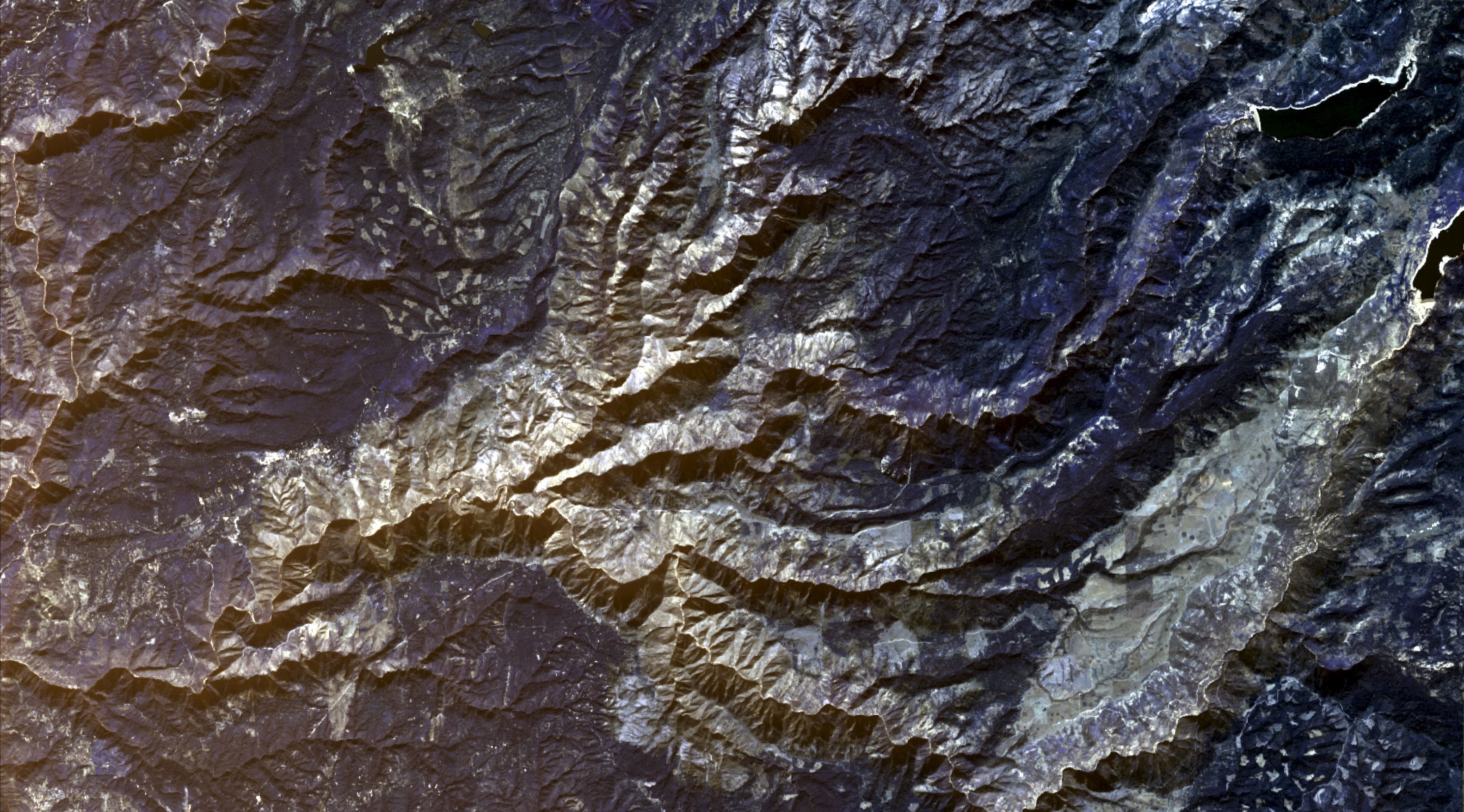
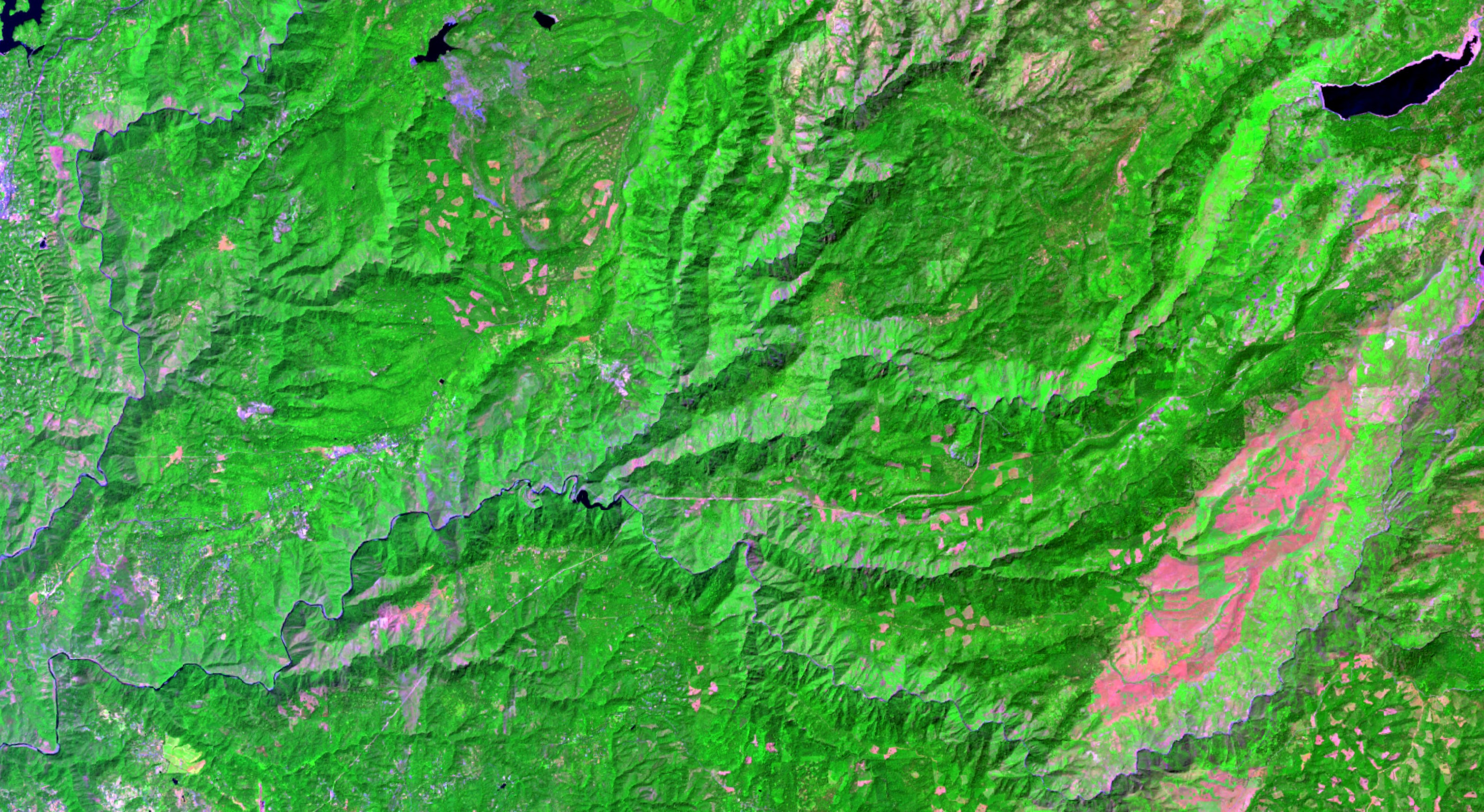
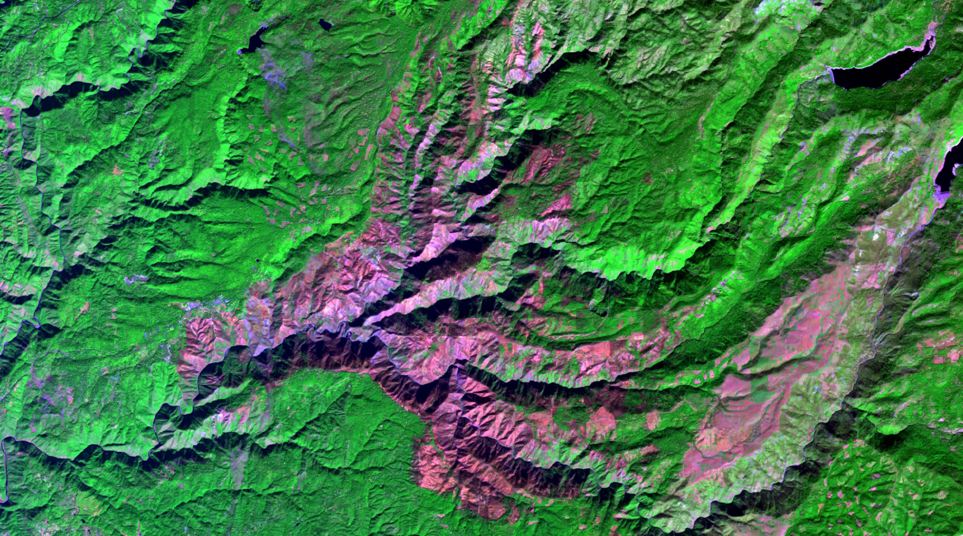
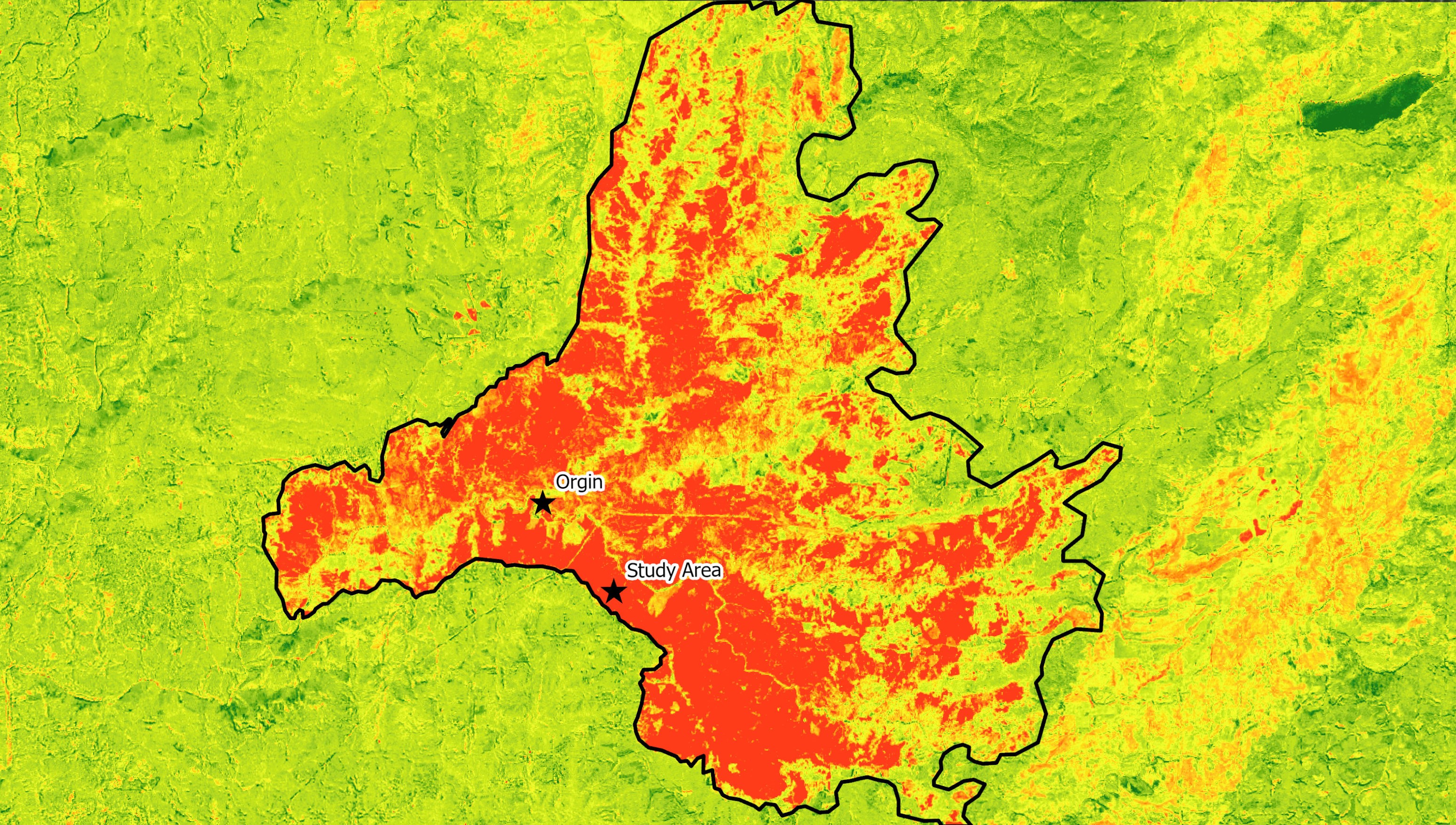
For assessing burn scars, various geoprocessing tools were used in ArcGIS Pro on Landsat 8 imagery downloaded from ESRI's Landsat Explorer (fig. 1 & 2). Imagery from August 2022 and August 2023 was downloaded and imported into ArcPro as .tiff files. The first step after importing the original imagery was to change the band combination to vegetation index, 4-5-7 (fig. 3 & 4). This combination revealed the stark contrast pre and post burn in vegetation within the burn area, which was especially relevant to the plant ecology portion of the project. Next, the normalized burn ratio tool was used to calculate the NBR on both the pre-burn 2022 image and the post-burn 2023 image. A change in NBR was determined by using the difference tool, which outputs a single image in grayscale visualizing the differences between two images. Once the difference image was created, a yellow-red color ramp was chosen to better suit the theme of the image, with the red representing areas of difference, indicating burn scar. A polygon feature class was created and the create polygon tool was used to trace the burn scar area. Referencing pre-burn imagery was essential to do this as there were multiple other burn scars from previous fires surrounding and intersecting the Mosquito Fire burn area. A point feature class was also created to note the point of origin of the Mosquito Fire and the location of the study area for plant data collection (fig. 5). Once the polygon was traced, the shape_area field was used to create a calculated field that determined the amount of acres of the burn area/scar. This number was 76,954.Compared with the actual determined number of acres burn, 76,788, the calculation was pretty accurate.
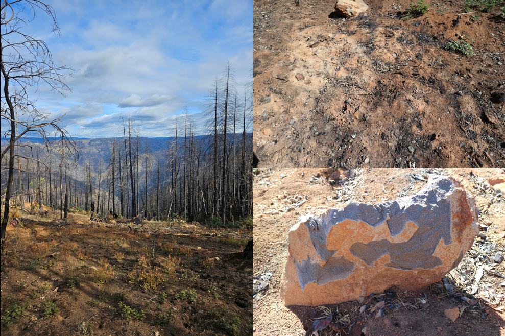
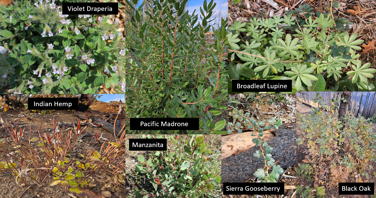
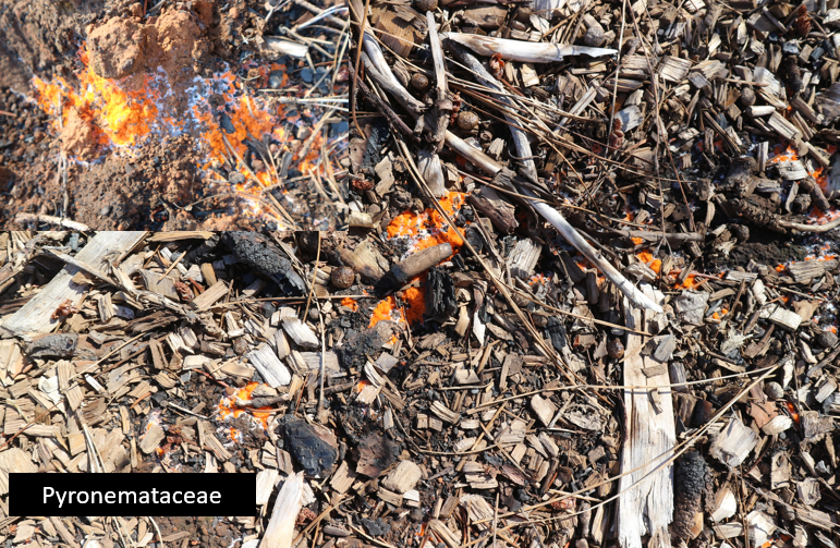
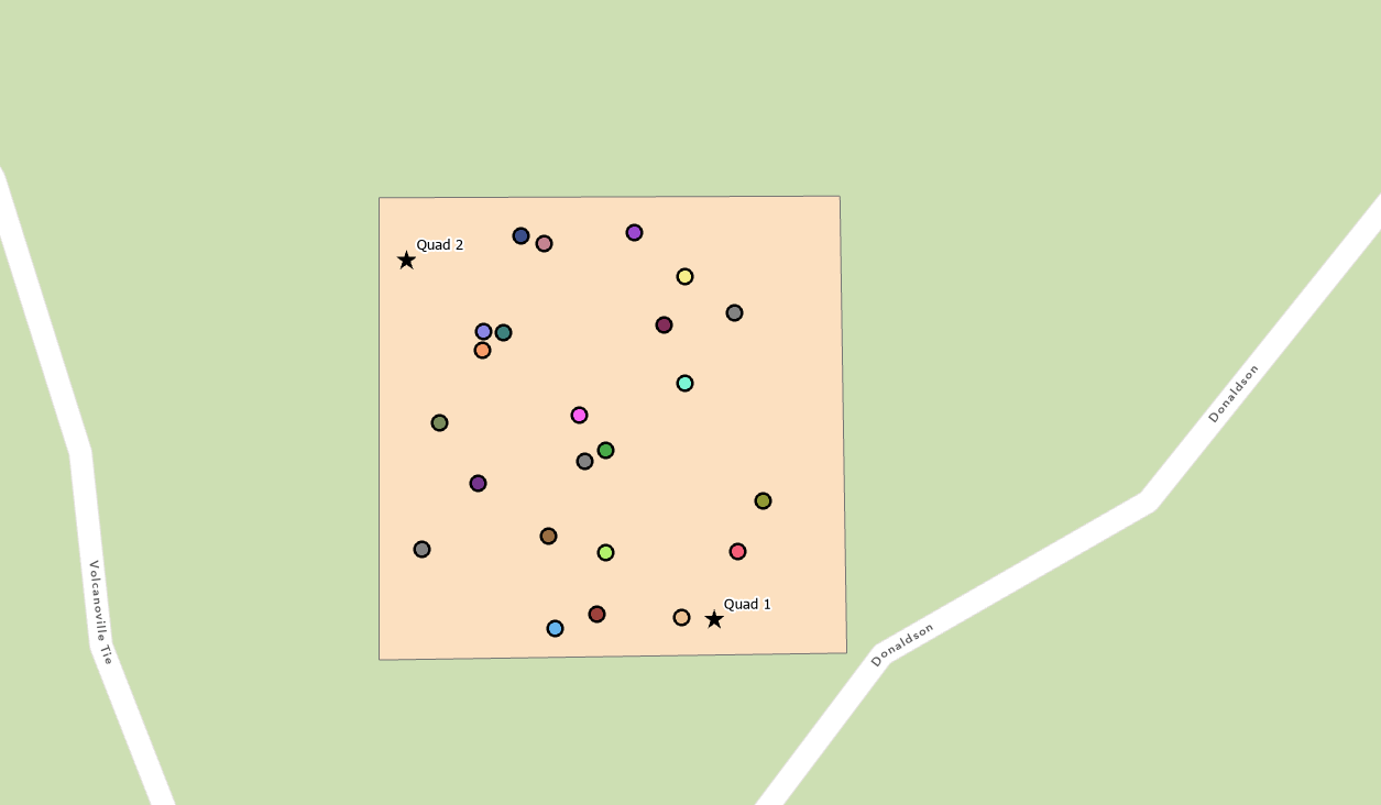
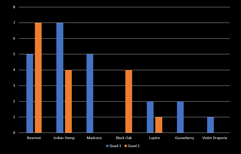
The next part of the project included collecting data from a study area about plants growing in the post-burn landscape. A study area was determined that was accessible and in a rural moderately burned area, with little other disturbance factors (fig. 6). This included taking photos on a smartphone with geotagging enabled. The study area was approximately 1/5 of a mile. Photos were taken of as many plants within the study area, ensuring that at least 1 photo of each type of plant was taken. Within the entire study area, 23 different genera of plants were identified. Botanical keys and books were used for identification. Identification focused on family and genus, rather than species, as to maintain data accuracy. Geotagged photos, one for each genus, were imported to ArcPro as point using the Geotagged Photos to Points geoprocessing tool. These 23 different genera were then uniquely symbolized to create a simple map. Also noted on this map were two quadrat sampled areas within the study area (fig. 7). Among the plants idenitfied included Pacific Madrone, Violet Draperia, Manzanita, Indian Hemp, Broadleaf Lupine, Sierra Gosseberry, Black Oak, Canyon Live Oak, Bearmat, Bracken Fern, Spreading Dogbane, White Hawkweed, Mullein, Aster, Ponderosa Pine, Cudweed, and various mushrooms of the pyronemataceae family which feed on wood ash. Some of these are featured in figure 8 & 9. To get a better sampling of the plants within the burn area, two quadrat sampling area were constructed. While quadrat samples are typically <1 square feet, the sample areas were 10x10 feet. This is to account for the fact that the study area was not a typical landscape, but one that had experienced moderate to severe disturbance, and a 10x10 sample area was more appropriate. Within the quad sampling area, each plant was identified, and their number of occurrences was recorded. A chart was then created displaying the number of occurrences (fig. 10). This additional sampling method helped to get a better idea of the density of certain plants within the study area.
Discussion
While an ideal research project would have encompassed multiple study areas across diverse locations and a more extended temporal scope, there were limitations imposed by time and logistical constraints. However, this work helped further my understanding of fire ecology and has made me interested in continuing to pursue studies like this in the future. The visualization of the Mosquito Fire's burn scar through imagery analysis provided a much-needed overview of the landscape's response to the wildfire. From the results, the fire appeared to have caused moderate to severe damage, as indicated by the changes in vegetation index and normalized burn ratio. However, the subsequent soil analysis conducted by El Dorado National Forest revealed a more nuanced picture, with the majority of the burn area classified as having experienced low severity. This disconnect indicates that my spatial analysis needed to go further than just NBR comparisons. Despite the challenges in determining burn severity, the diversity of plant genera identified within the study area suggests a resilient landscape rebounding well from the fire. The abundance and variety of native plants indicate a successful regeneration process, posing intriguing questions about the role of wildfires in maintaining ecosystem health. This observation aligns with growing ecological discourse suggesting that certain ecosystems, adapted to regular fire regimes, may require periodic wildfires for their ecological balance. In conclusion, while acknowledging the constraints of this study, the outcomes emphasize the importance of interdisciplinary approaches to comprehensively study the impacts of wildfires. The Mosquito Fire, as a case study, underscores the need for ongoing research that integrates spatial analysis, fieldwork, and ecological assessments to unravel the complexities of fire ecology and contribute to the broader conversation on sustainable wildfire management and ecosystem health.
Sources
Baker, David."PG&E Power Line Tripped Near Start of California Sierra Fire." Bloomberg, 8 Sept. 2022, https://www.bloomberg.com/news/articles/2022-09-08/pg-e-power-line-tripped-near-start-of-california-sierra-fire?leadSource=uverify%20wall
California Department of Forestry and Fire Protection. (2022, September 6). Mosquito Fire Incident Information. California Department of Forestry and Fire Protection. https://www.fire.ca.gov/incidents/2022/9/6/mosquito-fire/
Datta, Rahul. "To extinguish or not to extinguish: The role of forest fire in nature and soil resilience." Journal of King Saud University - Science, vol. 33, no. 6, 2021, 101539, https://doi.org/10.1016/j.jksus.2021.101539
McLauchlan KK, Higuera PE, Miesel J, et al. Fire as a fundamental ecological process: Research advances and frontiers. J Ecol. 2020; 108: 2047–2069. https://doi.org/10.1111/1365-2745.13403
U.S. Bureau of Land Management. "Fire Ecology Introduction." Bureau of Land Management, n.d., https://www.blm.gov/or/resources/recreation/tablerock/files/fire_ecol_intro.pdf
Waldman, Heather. "Soil survey reveals surprising information on severity of Mosquito Fire." The Sacramento Bee, 6 Oct. 2023, https://www.sacbee.com/news/california/fires/article265485301.html